day 4 – return to Laguna Ánimas

trip report by besthike editor Rick McCharles

day 0 | 1 | 2 | 3 | 4 | 5 | info Condor Circuit  

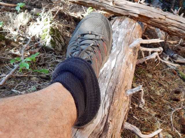
Sunburn was my biggest worry at this point. I had plenty of No-Ad Sport Sunscreen slathered on, but this sun is unrelenting. I was wearing socks on my hands as they were most burnt, so far.

IMG_4178

I made one last climb up to the “corner” of the valley to see if it looped back over a pass in the direction I wanted to go …

The cows thought I was crazy.

IMG_4184

I was crazy. Odds were slim that it would work. I turned back here.

IMG_4187

It was a relief, actually, to finally know where I was going.

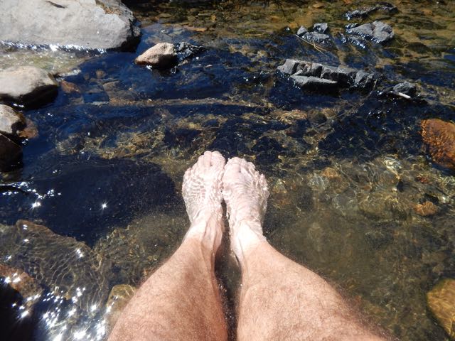
River crossings are a big issue here. There are no bridges. Happily this was the most difficult I crossed. Not bad.

IMG_4188

Descending to the hot springs, the group had already vacated. I had the place to myself. 🙂

IMG_4190

IMG_4197

One last look back up my side valley.

IMG_4198

Mid-day I took the shade and studied Spanish for 90 minutes or so. Then resumed my high traverse of the massif.

IMG_4202

Today the two condors came to check me out.

IMG_4207

IMG_4215

I was clinging to life yet. 🙂

IMG_4217

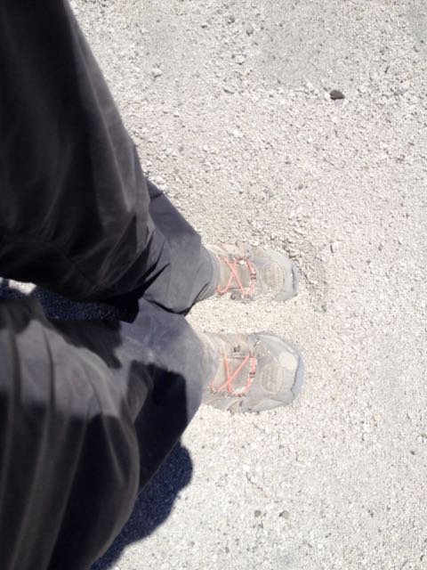
People curse slogging through ash. Personally, I like it. Very soft on the feet. The best screeing surface possible.

IMG_4218

I was surprised to come across 4 Chilean hikers in the afternoon. They had put up the tents and got directions from me to the hot springs. Two had just been married. This was part of the honeymoon. Both were just about to move to Montreal for work. Small world.

IMG_4220

One of the guys asked me if I knew the way back to the Pass. Of course I did. I’d just come from that direction.

How could I get lost? 🙂

IMG_4223

I got lost. 😦

Things truly do look completely different when walking the opposite direction.

My good camera had broken, the telescoping lens mechanism wrecked. 😦 I wasn’t in much of a mood to take photos in any case. 😦

My audio book – Red Rising by Pierce Brown – kept me going.

I was first diverted for about 2 hours. Then about 30 minutes. (Several times I considered backtracking to the honeymoon party tents. I could have walked out with them next morning.)

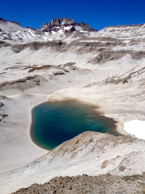
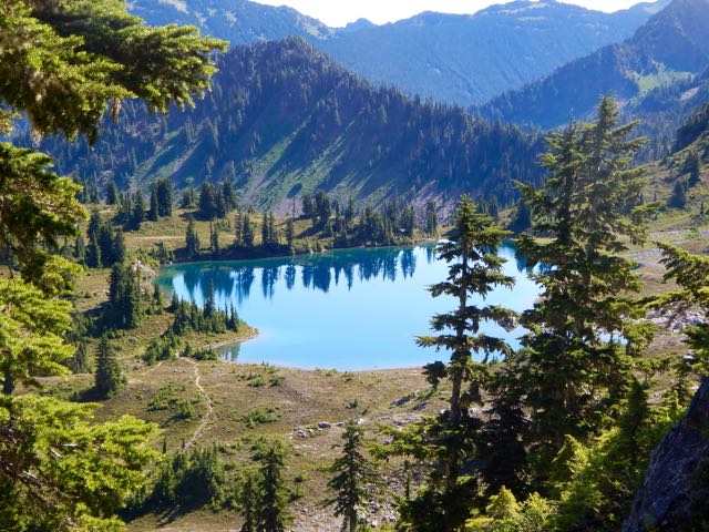
But – finally – I found the way back to Ánimas. I set up my tent above the lake at this junction of alpine meadow and desert. My best campsite.

IMG_4224

day 0 | 1 | 2 | 3 | 4 | 5 | info Condor Circuit  

day 3 – Laguna Ánimas to Hot Springs

trip report by besthike editor Rick McCharles

day 0 | 1 | 2 | 3 | 4 | 5 | info Condor Circuit  

Another lovely dawn. I packed up before the sun hit my tent. Fearing sunburn.

IMG_0472 IMG_4130

Pretty Laguna las Ánimas is a jewel in the midst of volcanic destruction.

IMG_4131

Atop the next plateau I was surprised to find yet another alpine meadow.

IMG_4132

If this region were not so volcanic, it would be very green.

Higher there was yet more water. But the scenery grew stark. Weird and wonderful.

IMG_4136

IMG_4135

IMG_4137

Looking back on my morning route.

IMG_4138

Above Ánimas there are no signs. No official trails. You are on your own. I’m sure people get lost and die here every year.

I hoped that was my highest pass up ahead.

IMG_4139

It was. 🙂 I left a Summit Stone.

IMG_4141

It would be an excellent idea to enjoy the massive and impressive Mt. Decapitated vista from here. And turn back.

Laguna Mondaca
Laguna Mondaca

IMG_4144

I dropped down to the other side crossing this field of snow and ash.

IMG_4145

Laguna Mondaca looked too great a descent for me. I’d really rather not drop down that far and have to climb back up.

A high traverse trail on the right looked much more tempting. Quickly I decided to stay as high as I could. Returning by the same route if that trail didn’t loop around back to Valle de Indio.

IMG_4148

I LOVE this kind of brutal & extreme landscape.

IMG_4147

IMG_4151

IMG_4153

Surprisingly, it’s quite easy to find water here.

IMG_4154

IMG_4155

Wildflowers were still thriving in January.

IMG_4159

IMG_4162

The unofficial trail was excellent. I stayed as high as I could.

Laguna Mondaca
Laguna Mondaca

Though I could see for miles in every direction, I’d seen no wild mammals at yet. Goats were grazing very high up, circled by two very interested condors.

IMG_0473

I tried to find some shade to take a siesta mid-day. This was one of the best.

IMG_4169

I set up the tent to keep flies and wasps away.

IMG_4174

This was a long but comparatively easy day, mostly gradually downhill. I decided to enter a side valley hoping it would loop back to where I started. (My GPS did not work and I had no map, so this was wild speculation.)

IMG_4175

Entering the valley I smelled sulphur. I’d stumbled on to one of the many natural hot springs in the area. But a horse group was already camped there. I decided to wait until next day to have my bath.

I set up high and out-of-sight since there were cattle and people in this valley.

IMG_4176

day 0 | 1 | 2 | 3 | 4 | 5 | info Condor Circuit  

Vilcabamba Trek to Machu Picchu

Mark Whitman of Kandoo Adventures helped us put together an information page on the Vilcabamba Trek in Peru.

The original Lost city of the Inca. A great alternative to the Inca Trail.

AT A GLANCE

Peru
Peru
  • Begin in the Vilcabamba Valley
  • Walk 5 days to Machu Picchu
  • dry months May-September are best
  • Perhaps the toughest Inca trek
  • Three high passes
  • Hike with a guide or independently

Why We Like This Hike

  • Finish at one of the world’s most incredible destinations – Machu Picchu
  • ‘off-the-beaten-path’
  • No permit required
  • Peru is one of the world’s best hiking nations
  • Very quiet – you won’t see another hiker
  • A more authentic Peruvian experience than the crowded Inca Trail
  • Trek on well preserved Inca trails
  • Visit rarely seen Inca ruins, including Vitcos-Rosaspata and Ñust’a Hisp’ana
  • Great challenge for experienced hikers
  • Dramatic scenery and snow-capped peaks
  • Hot springs near the end of the trek

 Vilcabamba Trek to Machu Picchu

Click through to learn more.

Click PLAY or watch Kandoo Adventures’ itinerary on YouTube.

We’re looking for trip reports from independent hikers. Reply to this post if you know of one.

High Divide Loop (7 Lakes Basin)

trip report by site editor Rick McCharles

I was en route to hike the Cape Alava to Rialto Beach “Shipwreck Coast” on the Olympic peninsula end of June.

But when I dropped by the the Wilderness Information Center in Port Angeles on the way to the trailhead, Rangers informed me that famed High Divide Loop (7 Lakes Basin) was open early this year. Winter had dropped very little snow on the high peaks.

I instantly changed my plan. You can hike the Shipwreck Coast almost any time. But the High Divide Loop window is time limited. Late July to mid-October most years.

The High Divide Loop is very weather dependent. I arrived during a heat wave. Blue skies. Quite rare in the high mountains of the rainy coast.

It turned out to be a good call.

Rick Mt Olympus

AT A GLANCE

  • the jumping off point (and best finish) for the High Divide Loop is Sol Duc Hot Springs in Olympic National Park
  • 20.3mi (32.6km) including sidetrips to Lunch Lake and Bogachiel Peak
  • must carry a tent and be completely self-sufficient
  • cumulative elevation 5200ft

On the advice of a Ranger, I booked 2 campsites:

  1. Deer Lake
  2. Sol Duc Park (near Heart Lake)

Circuit map

I started with the day hikers heading up to Sol Duc Falls.

High Divide - 3

High Divide - 4 High Divide - 2

It’s a steep up,up,up from there to Deer lake. Nice campsite. But it did have mosquitos. I was happy to have carried my mesh bug shirt.

Deer lake

The Park was extremely dry while I was there. Normally you get wet feet on this hike. Boardwalk helps.

High Divide - 6


I used the instagator technique to keep pebbles and dust out of my approach shoes.

High Divide - 12

This was my first glimpse of Mt Olympus next morning. I was very pleased the skies stayed clear. This summit is usually cloud shrouded.

High Divide - 11

Though the old growth forest trails are tranquil, it was fantastic to get above the tree line.

High Divide - 10

I love the bear grass, but wildflowers were less prolific than expected.

High Divide - 17

I stashed my pack on the ridge and dropped into  into 7 Lakes Basin for some day hiking.

High Divide - 14

It is marvellous.

High Divide - 18

Climbing back up to the ridge I continued to one of the most famous viewpoints in the Olympics, Bogachiel peak.

High Divide - 19

The ridge walk above the basin is fantastic in clear weather. You look down on the many-more-than-7-lakes.

High Divide - 24

I was exhausted and dehydrated by the time I finally dropped down towards Heart Lake.

High Divide - 25

Rangers there told me where I could find good water. There was none on the ridge. 😦

I had been counting on melting snow. Unfortunately I found no snow.

With relief I set up my tent at Sol Duc Park campsite. Washed my feet. And took an hour siesta.

High Divide - 26

In the late afternoon I made a long day hike past Cat Basin campground to see what my guidebook claimed was the best view of Olympus. I wasn’t disappointed. 🙂

High Divide - 29

Next morning was an easy downhill exit through old growth. Very mellow.

If you’d like to see 7 Lakes Basin and Mt Olympus for yourself, check our new information page.

Banff Alberta in winter

I stayed a February night in Banff, one of our top 10 hiking towns in the world.

Wanting to do some day hiking, I stopped by the National Parks office for advice.

16513487851_3ee96da7a8_z

Unfortunately, the local trails are a mess in winter. Snowy, icy and often CLOSED.

15895041213_2dea960a89_z

I still managed a short afternoon walking from town to the Banff Springs Hotel.

16489200416_fc3552b195_z

Shortly after I gave up. And caught the bus up the mountain to the Hot Springs.

16489199906_c0c18fd522_z


I’ll come back in summer. 🙂

off trail in Iceland

Hank Leukart:

Two brothers search for eternal life in the Icelandic wilderness during what may be the last time in history anyone is able to see all of Iceland’s natural, untouched beauty.

Click PLAY or watch it on Vimeo. (17min)


Because my brother and I live so far apart (he’s in New York; I’m in Los Angeles), we have agreed to reunite once every year, somewhere in the wilderness. We’ve been to Alaska’s Denali, Chilean Patagonia, and even Everest Base Camp, but, for our most recent trip, we set our sights on a hard-to-reach lake in the Icelandic wilderness called Eilísvötn, which, in Icelandic, means “Lake of Eternal Life.” …

Brian and I start by trekking two classic, connected Iceland treks: the Fimmvörðuháls and Laugavegur Trails, the first of which begins at a huge waterfall called Skógafoss on the southern coast.

We feel almost disappointed to be enveloped by the sublime, rolling, green hills and plethora of waterfalls, because it feels like we’re in the most beautiful place in Iceland already — we’re getting a fantastic payoff way too early in our trip. Soon enough, though, as we continue through the snow and glaciers near Fimmvörðuháls Hut, it becomes obvious that there’s no chance Iceland will ever disappoint us no matter where we go. …

Without Baggage – Mission Iceland: A Tale of Two Brothers

Selfoss

I’m researching a possible Aug/Sept 2015 hike. Laugavegur is very, very high on the list of treks I want to do next. 🙂

researching Fish River Canyon, Namibia

The Fish River Canyon 5 day trek is one of the best in the world.

But it’s very difficult to get a reservation, even a year in advance. I’ve been turned down for all dates in June 2015. 😦

But I may try to show up at the trailhead anyway. Hang out. And look to substitute for a hiker missing from a booked group. (You must have a minimum of 3 people to register, in any case.)

Wish me luck.

- by  Daniel Smith
– by Daniel Smith

I’ve put up a draft information page on the Fish River Canyon trek with what I was able to find out online.

Leave a comment if you have any advice.

Langtang Trek – day 1

Trip report by site editor Rick McCharles

Kathmandu 1400m to Syabrubesi 1503m to Pairo 1800m (Landslide)

I was at the Macha Pokhari bus area in Kathamandu by 6:30am.

There did not seem to be any Jeeps at the Jeep counter, so I went directly to the bus ticket wicket. Very quickly I had in hand an assigned seat on the next Super Express for $5.

P1310743

My assigned seat was the most cramped on the rig! Tight even for a Nepali.

Happily, one of the guides offered to swap my seat for his … beside a gruff, old German client.

Super Express was not bad. Far better and smaller than most Asian buses.

P1310738

The bus did fill. With people. Luggage. And radish.

P1310737

It would end up taking 7.5hrs total to Syabrubesi. Not too bad for Nepal.

We had a terrific driver. Very skilled. Very careful.

Though a Nepali bus (killing tourists) had crashed just a few days before, our cliff edges were never scary close.

The rear view mirror may have been nudged a time or two.

P1310733

P1310749

Only one landslide delayed our upward progress.

I skipped breakfast. Ate only a few Digestive Biscuits at lunch. In my experience, it’s better to ride Himalayan buses on an empty stomach. With an empty bladder.

Instead of lunch, I wandered the stopover town.

P1310742

P1310739

Sections of the journey were pretty.

P1310735

My only one reservation with the driver were times when he and another bus driver played music back and forth using horn and noisy brakes. (VIDEO)

Three times en route we disembarked at checkpoints. The first only looked at our TIMS card. The next two required both TIMS and our Langtang National Park permit.

P1310751

I had paid for both in Kathmandu, but some on the bus were missing one or both. Happily, you could purchase them at the checkpoints.

We disembarked Syabrubesi 1300m at 3:30pm.

I had late “breakfast” and enjoyed free wifi before starting up the trail. Very late in the afternoon.

Everyone else spent the night in town. I was rushed to get high.

P1310754

P1310756

P1310759

P1310760

P1310764

P1310769

I walked about 90 minutes up to Pairo (Landslide or Hotsprings).

P1310778

___
Marketing 101:

Good marketing is calling your lodge Hotsprings. Bad marketing is calling your lodge Landslide.
🙂
___

Great lodge. I had fun my first night chatting with a Brit and his Guide who were boozing, celebrating the end of his adventure. Sadly, the hotsprings were not available as a bridge had washed out. It was supposed to be repaired by the time I came back down trail in a week.

see all my high res photos from this day

___

Heading up trail towards Pairo is by far the most popular start to the Langtang trek. More scenic, but longer and tougher, is starting towards Khangjim 2235m instead. The mantra is “slowly, slowly” on the way up. Walking via Khangjim is slower, better for acclimatization for altitude. I should have gone that route.

day 0 | day 1 | day 2 | day 3 | day 4 | day 5 | day 6 | day 7 | day 8 | info | … Gosainkund

Colca Canyon, Peru

We’ve moved and updated our Colca information page. 🙂

A trip to Colca Canyon is recommended for all hikers, regardless of ability and experience. It offers superb day hiking and immensely popular 2-day trips.

Bruno Iglesias
Bruno Iglesias

Hard core hikers will love a unique 5-day option descending into the canyon then climbing up over a snowy 5100m (16,732ft) pass to the remote and rarely visited Valley of the Volcanos — weird cones & lava formations!

AT A GLANCE

  • canyon of the Colca River in southern Peru
  • depth of 4,160m (13,650ft) more than twice as deep as the Grand Canyon

Yeti Adventure Films nailed the feel of Colca in this cute edit. 🙂

Click PLAY or watch it on YouTube.

details on our Colca information page