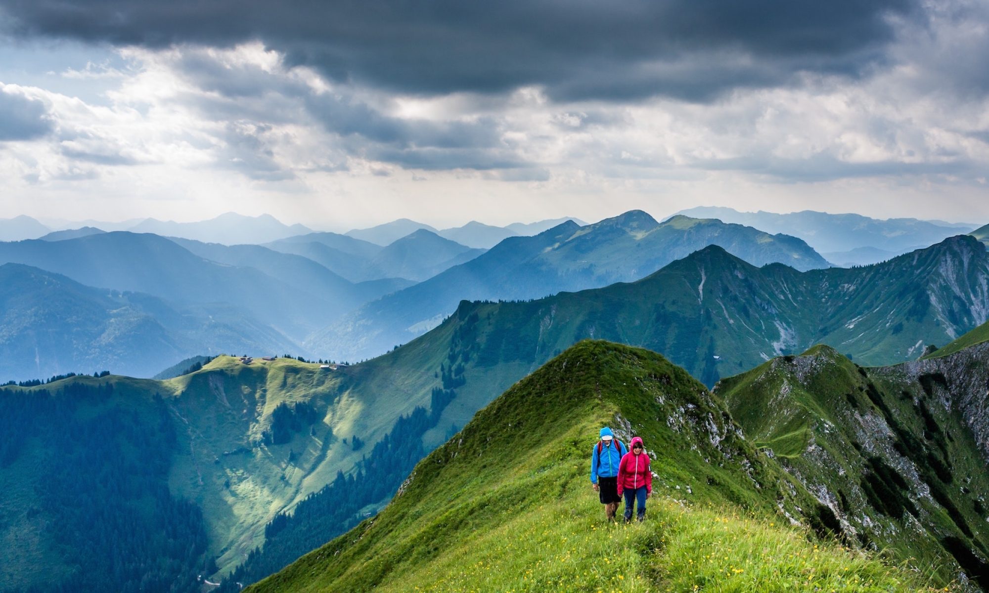
Hiking Segla & Hesten, Arctic Norway

Trip report by BestHike editor Rick McCharles

Click PLAY or watch get a glimpse on YouTube.

I climbed famed Segla in 2022.

In 2023, returned and climbed Hesten. Set up my tent.

 5.3-km out-and-back.

Wait on the weather. You want the summit of Segla to be visible.

The best views of Segla are from Hesten.

Hikers on Heston looking over to Segla

There are a couple of trails up and down Heston. Some require scrambling.

Best months are June through September.

Ximonic (Simo Räsänen) 

The views are spectacular. This is definitely one of the very best hikes in Norway.

Looks good?

First you need to get to Senja Island in remote Arctic Norway. 😀

More photos.

Hiking Brosmetinden out of Tromsø, Norway

Trip report by BestHike editor Rick McCharles

I flew to Tromsø — well above the Arctic Circle — to begin a long bikepacking tour of the west coast.

In good weather there are MANY great hikes out of Tromsø — but the best close to town looked to be Brosmetinden.

I was inspired by the post by local hiker Maria Wulff Hauglann:

7 Easy Hikes With Spectacular Views In Tromso, Norway

I followed Maria’s recommendations, using AllTrails for navigation.

The 1-hour drive (from downtown Tromso) out to where the Brosmetind walking path starts is fantastic too.

… valleys with tall peaky mountains that go straight into the sea.

One of these fjords is Grotfjord. You should make a stop in Grotfjord and walk along the huge white-sandy beach.

You will have an awesome panoramic view from the start to finish. So if you don’t have to go all the way to the top to get a great view. You can turn around whenever you want …

  • Height: 525 meters above sea level
  • Distance to walk: 4 km both ways
  • Time: 1-2 hours (round-trip)

How to get there by bus: Take the district bus no. 425 to Tromvik or Rekvik, and walk from there to the starting point of the hiking path to Brosmetinden. Tell the driver that you want to hike Brosmetinden and he will let you off at the right place.

You can purchase tickets on board the bus, but cash payments only, or you can buy a ticket through the app “Troms Billett”. You can check the bus schedule HERE (search the Travel Planner from “Tromsø Prostneset” to “Rekvikvegen (Tromsø)” or through the app “Troms Reise”.

I hiked on Canada DayJuly 1st. Wore my CANADA clothing. 🇨🇦

Weather was sunny — but super windy. Too windy to fly the drone. But it was nice to have enough wind to blow away the mosquitoes and horseflies.

It’s a quick hike to reach the sea cliffs. And a scenic scramble up to the top.

I camped at Grotfjord beach, on Maria’s recommendation.

An excellent short day hike — but quite a detour off the usual tourist route.

I cycled an extra 64km to get there.

Meet hiker Kraig Adams

I’m following everything Kraig does.

His YouTube channel. His podcast.

Though young and fairly new to hiking, Kraig impresses me most with his videos.

His hike in Iceland last year, for example, has over 3.3 million views on YouTube.

Stark. Quiet. Elegant simplicity.

Instead of famed Laugavegur, he hiked remote Hornstrandir solo instead.

Click PLAY or watch it on YouTube.

One of his personal favourite hikes was Picos De Europa in Northern Spain.

I agree enjoy it immensely in 2009.  And got lost, as did Kraig.

Kraig had planned to do the PCT in 2020.  That was cancelled due to COVID-19.  Like many of us he’s coming up with alternative adventures legal and ethical.

Read a recent interview on hiiker.


hiking the Tombstone Range, Yukon

by BestHike editor Rick McCharles

Dustin Walker put together a list of less well known trails on his site Slick and Twisted Trails:

10 Hidden Hiking Gems: Outdoor Writers Share Their Fave Little-Known Backpacking Routes


Dustin picked Keeha Beach/Cape Beale Trail, B.C. — a wild challenge.

I shared my trip report from our very memorable 2007 adventure. This incredible in the north had only been designated a Provincial Park in 2004.

There are a number of ways to hike Tombstone. The best is to chopper in, hike out. At $20 / minute, we each paid over $200 for the one way flight.

1122625055_1dccd530a6_b

This was a bit of a hiking honeymoon for Dana and Bill who had been married just a few weeks earlier.

1123489032_f704d575ab_b

1122679925_70d3b4cff1_b
 Divide Lake campground

Grizzly Lake campground is just as lovely as Talus and Divide.

1123584924_905a876c76_b

View over 125 photos from this trip on flickr.

Tombstone Park – Yukon government

Read my trip report

best way to hike Lofoten Islands, Norway

Lofoten is without question one of the best hiking destinations in the world.

Bunes Beach hike

But it’s remote.

Also, Norway is very expensive.

The gateway for most people is the town of Bodø, the end of the train line north. It’s often cheaper and easier to fly as the train is a 17 hour overnight journey.

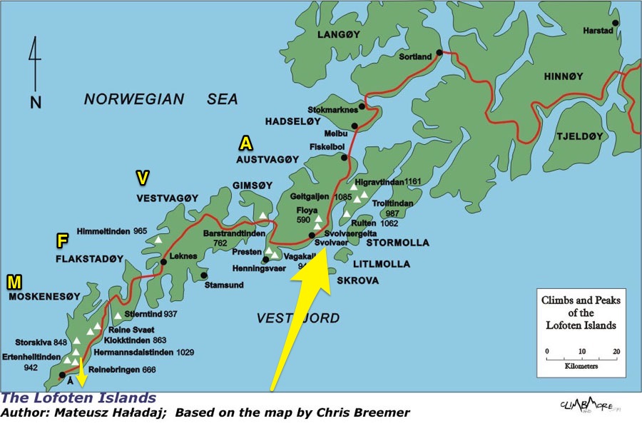
From Bodø you have options. If you don’t have your own transportation easiest is to make a loop by ferry and bus.

Take the fast passenger ferry Bodø to Svolvær. About 4 hours.

Your first hike should be Fløya & Devil’s Gate. The trailhead is about a half hour walk from the ferry landing.

From Svolvær you would take buses or hitchhike the only highway west through islands A to V to F to M. 

M Moskenes (Moskenesøya) has the best hiking. Save it for last.

Reine is the best base town for Moskenes. You can do 3-4 awesome hikes out of the same town.

From the village of Å (the last letter of the Norwegian alphabet) you can catch the slow ferry back to Bodø. About 4 hours.

The weather is dreadful. For any 7 day period during the hiking season you may have several days of serious wind and rain. These should be rest days if you have time.

If you have your own vehicle — or decide to rent a car — you can go when and where you want. That’s ideal.

related – travel 2 walk – trip report: Norway – Bødo & Lofoten Islands, August 2017


Norway – hiking Solstien out of Rjukan

trip report by BestHike editor Rick McCharles

Driving in after dark, I slept at the base of Mt. Gausta, Norway, hoping to get a very early start.

It’s the highest mountain in Telemark, a super popular hike.

When I awoke, however, it was cloudy atop the peak.

After making some coffee I finally decided to drive on and hike instead nearby Hardangervidda plateau.

I drove way, way down to Rjukan town.

For 6 months a year no sun reaches this deep valley.

Why would people live in Rjukan?

Hydroelectricity, of course.

Rjukan Falls, a 104-metre waterfall, provided easy means of generating large quantities of electricity. In 1934 this was the world’s largest power plant.

Easiest way up the opposite side of the valley is via the Krossobanen aerial tramway, built 1928 as a gift from Norsk Hydro to the people of Rjukan (most of them Hydro employees), offering them a view of the sun during winter.

Actually that’s the oldest in Scandinavia. It looks old.

I was in the first car. Happy to gain 814m quickly.

There’s a restaurant and good views across the valley to the mountain.

At the top of the lift I was a bit disappointed to see road, cabins, snow machines, quads. It’s a community up here, not wilderness.

Lonely Planet recommended a 9km walk-in to Helberg cabin.

I had been advised the hike was wet. And it was wet.

Hardangervidda is characterised by barren, treeless moorland interrupted by numerous pools, lakes, rivers and streams. Erosion in this environment makes any trail muddy. Too wet for me.

I turned around.

Instead I tried the Solstien loop. I knew it had a stepping stone stairway. I could keep my feet relatively dry.

Nice.

The sun came out as I got to the top.

Germans in World War II tried to produce heavy water for future nuclear weapons in this valley.

They built these gun emplacements to shoot down British planes.

This weird, bleak, inhospitable environment really appeals to me. I recommend the hike.

By the way, I small-stepped down the 814m back to my car. It did seem long.
___

There’s some good news. The people of Rjukan now get some sunlight without climbing out of their valley. Martin Andersen, an artist who moved there in 2002, pushed an initiative to build a computer-controlled array of three giant mirrors that moves with the sun to light 600 square meters of the town square.

related – Visit Telemark – Solstien

Laugevagur hike Iceland – day 3

Day 0 | Landmannalaugar | 1 | 2 | 3 | video | info

day 3 – Þórsmörk (Básar) to Skógar

25km, 10-12hrs

When I think back on Laugevagur, my first thoughts are of the amazing waterfalls on the last day. Is there a more spectacular chain of falls anywhere else on Earth?

Happily, the weather was quite good when I woke early. Then a thunder storm rolled in and disappeared before I’d finished coffee.

Later I learned that Mark was already up high. Very nervous. There’s no place to hide from lightning in Iceland.

Here I was psyching up for the 900m climb to Fimmvörðuháls pass.

I knew it could be a long, tough day climbing to the icefields up on a high plateau. It’s the most glaciated section. But at least there are NO RIVER CROSSINGS!

The ascent was quite easy, as it turned out.

What’s this?

These were the first hikers I saw coming the other direction. Doing this with a day pack is quite popular.

Stunning views.

Recall the 2010 volcano that disrupted air traffic all over Europe?

This is it. You walk that massive lava flow.

Moodi and Magni (Thor’s sons) are two summit cones pushed up in 2010.

Magni

Everyone climbs Magni to enjoy the 360 degree view.

One worry late in the season is the snowfields turning to slush. Or water.

Happily, it was still good walking for me on July 29th.

Baldvinsskali is a small emergency hut en route. Hikers are allowed to escape the wind and elements if needed.

My only complaint about this hiking day is some road walking on the way down. I’d prefer they make a parallel walking trail.

How far to Skógar?

Waterfalls begin.

The trail follows the river down.

Every tourist to Iceland visits the falls at Skógar.

Made it!

About half way through the day I’d decided to bus back to Reykjavík, if I could. Mark was shooting photos at the base of the falls. I bought a ticket on his bus.

You could stay over. Skógar has a hostel and camping. As well as several restaurants.

Day 0 | Landmannalaugar | 1 | 2 | 3 | video | info

Laugevagur hike Iceland – day 2

Day 0 | Landmannalaugar | 1 | 2 | 3 | video | info

Hvannagil to Þórsmörk (Thorsmork)

26km, 10-12hr

Hoping to make a huge day, I was one of the first to leave camp. In the fog.

Bleak and flat to start.

Bridge! Thank God.

What an epic landscape!

Quite quickly you arrive at this pretty tourist area built 1995.

I had some hot brunch in the cook tent. Then moved on quickly. Some stop here to climb one or two summits as day hikes.

More bridges!

Interesting geology at every turn.

I was missing that brief bit of blue sky from yesterday. Everyone wore their rain gear today.

This is volcanic ash. Worse than sand, it gets into everything.

Oh my. This is amazing.

My first … tree !?

Trees are rare in Iceland. But there are plenty in Þórsmörk (Thorsmork)… Thor’s forrest.

(Iceland was actually 25% forested at one time. Timber cutting resulted in only about 1% remaining.)

When you finally arrive Þórsmörk you need choose between 3 separated campsites: Húsadalur, Langidalur or Básar.

Husadalur is biggest and has a natural hot springs.

But if you plan to continue hiking next day to Skógar, Básar is the best choice. It’s closest to the exit trail for next morning.

That’s where I headed.

Langidalur is pretty, however. The tenting looks superb.

I met again two Canadian women waiting for the bus. They’d had enough of rugged Laugevagur. Here’s the vista that dissuaded them from climbing up to the glaciers next day.

It does look intimidating.

If you do decide to linger at one of the 3 campsites, there’s even more day hiking here than at Landmannalaugar

Básar is sprawling. Busy with campers and day hikers.

I asked for advice on a quiet tent spot.

While I was eating dinner Mark from Boston arrived.

He and I were the only two from the start who had made it this far, this fast. We both planned to get an early start next day and finish to Skógar. It would be the toughest and best day of all.

Day 0 | Landmannalaugar | 1 | 2 | 3 | video | info