
World → South America → Patagonian Andes → Chile → Condor Circuit
One of the best hikes in the world
Condor Circuit
This adventure is also known as …
- Circuito Cóndores
- Altos del Lircay – Parque Inglés (Parque Nacional Radal 7 Tazas)
Note: This page is a stub. We have not done the whole thing. In Jan 2016 we did hike both ends separately. You can recommend improvements by leaving recommendations or links in the comments on this page. Our editors will consider them. Thanks for your help!
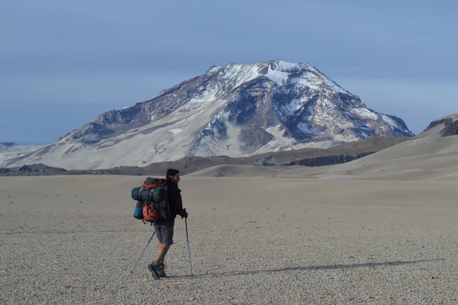
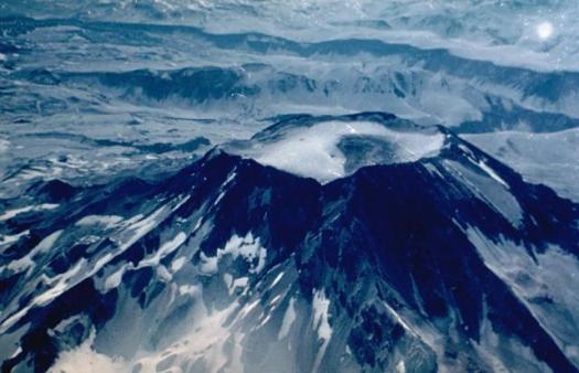
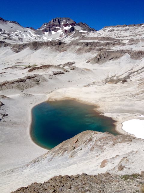
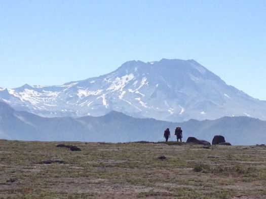
Descabezado Grande (also Cerro Azul or Quizapu) is a stratovolcano located in … central Chile. It is capped by a 1.4-kilometre-wide ice-filled caldera and named for its flat-topped form, asdescabezado means “headless” in Spanish. A smaller crater about 500 metres (1,600 ft) wide is found in the northeast part of the caldera, and it has active fumaroles. …
 AT A GLANCE
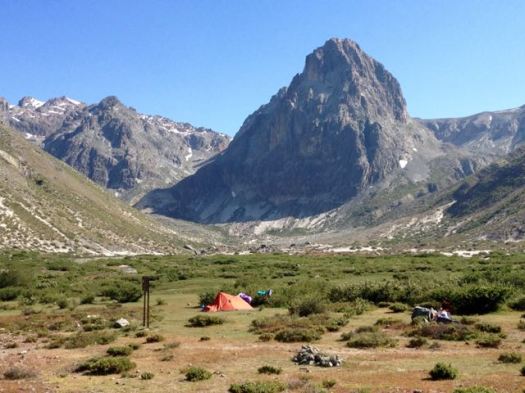
- a monster volcano 3953m (12,969ft) changed this landscape dramatically
- though the last major eruption was 1933, the environs are still wasted
- lava fields and ash trails
- November to April (though you may need an ice axe and/or crampons before mid-January)
- recommended 6-8 days plus optional 1-2 days to climb Descabezado as a side trip
- arguably this adventure is just north of the “Patagonian Andes”. We’ve included it in that section anyways. 🙂
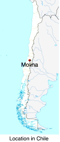
- the closest access point is Molina, about 250km south of the Santiago airport
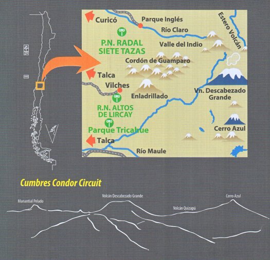
- the trail is not shown on this graphic below, but it gives you an idea of location relative to the cities of Curicó and Talca
Why We Like This Hike
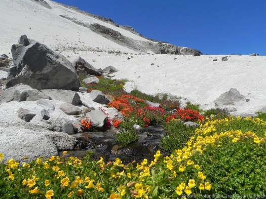
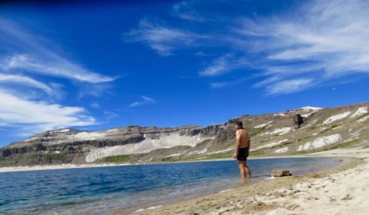
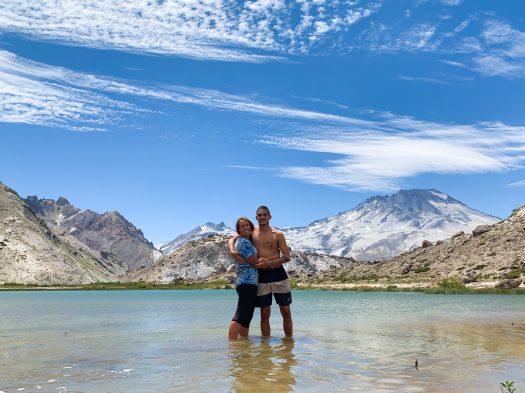
- stark, weird and beautiful volcanic vistas
- remote, uncrowded … except for the two end points
- low risk of altitude sickness
- fantastic views of Descabezado Grande
- the days are long in Patagonia during their summer — it is light until at least 9pm
- no special trekking permit is required – only Park entrance fees
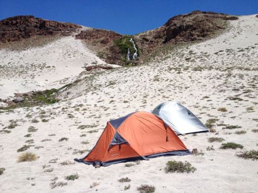
- no fees for the rough campsites
- surprisingly, finding water is not all that difficult
- gorgeous forest with big trees near Lircay
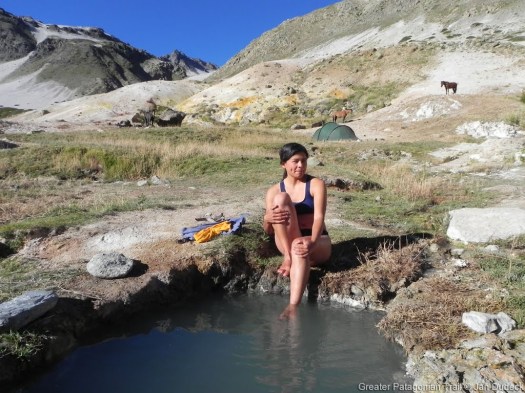
- hot springs en route
- we did see condors … but no other indigenous mammals aside from large hares
- screeing volcanic ash is FUN
- gorgeous water falls including the famed 7 cups in Parque Inglés
- wildflowers in the desert are astonishing
Considerations
- NO open fires allowed. In fact you may be checked to see if you are carrying a camp stove.
- some use the name Condor Circuit for a shorter route close to Lircay
- bring sunscreen and protective clothing
- because it’s more a route than a trail, navigation is critical. The Gaia GPS app has been recommended.
- some creek and river crossings, normally not a problem. But early season or after major rainfall you may be forced to backtrack
- this hike is remote. If you get lost, it’s possible nobody will ever find your corpse.
- only the ends are well signed and marked. The section near the volcano is not developed nor maintained. The route is often unsigned aside from (often confusing) small cairns. If it snows you may have no idea where the use trail has disappeared
- plan for terrible weather — rain, sleet, even snow is possible
- snow field crossings likely
- Jan to March are the best months
- the Patagonian Andes have terrific potential for hiking, yet the infrastructure is not much developed
- tent essential
- wasps are numerous – but we didn’t see any other biting insects
- no toilets at the wild camps
- it can get cold, though hypothermia is not a big risk during the hiking season
.JPG)
Cost
- Budget a minimum of US$40 a day to travel Chile. Days on the trek will save you money.
- Buses are good quality. Good value, however.
- Park entrance fees were 2500 pesos for Chileans, 5000 pesos ($7) for foreigners in 2016. 1200 for elderly. 1000 for children 6-18.
- Back country campsites are free. Those near roadways may charge 3-4000 pesos / person / per night.
Routes
There are many, many options. Here – for example – is a route recommended by guides Andes Explora.
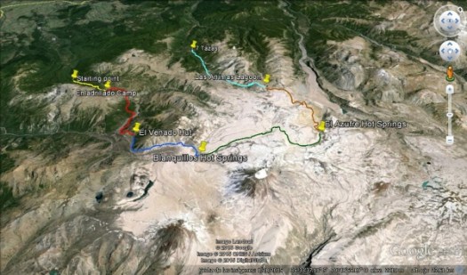
- Enladrillado camp
- El Venado hut
- Blanquillos hot springs
- El Azufre hot springs
- Las Animas laguna
That’s very fast. I’m assuming those groups are supported by pack animals.
This one is more realistic.

You could certainly do the red route in either direction. You’ll endure a lot of vertical ascent and descent either way.
An alternative to the Condror Trail, perhaps even more difficult, is GPT 1: Volcán Descabezado. (103km) That’s section 1 of the new Greater Patagonian Trail. Downloading the GPS track is essential as you are even more off-trail than on the Condor circuit.
Trekking Guides
- Coigue Expeditions
- Viator
- Andes Explora
- try local guide Luis Ramirez 071-681992 or quizapuguiaventura (a) hotmail.com
- try Costa y Cumbre Tours in Talca
info (a) costaycumbretours.cl
WhatsApp +56-9-99435766
Leave a comment if you know of others.
Logistics
To or from Parque Inglés (Parque Nacional Radal 7 Tazas)
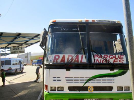
Many arrive from or depart to Santiago. From the big city head for the main Santiago bus station (University of Santiago metro station) > bus to Molina > bus to Radal Siete Tazas National Park. There are at least 2 companies in Molina on that route.
Happily in high season (Jan/Feb) buses go all the way to the CONAF Ranger Station. (The rest of the year they stop in Radal, 10km short.) It’s a bad, bumpy road up into the mountains. If it rains, the bus may not go all the way.
To or from Altos del Lircay
Buses Vilches goes to and from the main Talca bus station to the entrance to the Park entrance a number of times each day. It’s another couple of km walk uphill to Conaf Administration where you pay your entrance fee. A great Conaf campground is about 500m further on.
As always, check your logistics as best you can before heading for the mountains. Things do go wrong in the Andes.
Local Information
- Conaf (Corporación Nacional Forestal) is responsible for Parks in Chile.
- Conaf Altos de Lircay Reserve (phone 90643369)
Best Trekking Guidebooks
- Lonely Planet Trekking in the Patagonian Andes 2009 does not include this route
- Trekking por Chile 40 Rutas 2015 (Spanish) … widely available in Chilean bookstores only includes the Altos del Lircay section
Leave a comment if you know of a guidebook that does include the Condor route.
Best Travel Guidebooks
Related Books
- Enduring Patagonia – Gregory Crouch
Crouch is ideal reading when tentbound due to weather. 🙂
- In Patagonia – Bruce Chatwin
- Baja to Patagonia – Larry Rice
- Nowhere Is a Place: Travels in Patagonia – Bruce Chatwin, Paul Theroux, Jeff Gnass
- Patagonia: Wild Land At The End Of The Earth – Tim Hauf, Conger, Jr. Beasley, Gregory Crouch
- Lonely Planet Trekking in the Central Andes 2003
Best Maps
- Condor Circuit 1:50.000 waterproof trekking map of Chile Map 2013 (most recommended)
- Compass TREKKING MAP CONDOR CIRCUIT
- Condor Circuit – Wanderkarte, Zentralchile, 1:50.000
A map is essential. And a good compass or GPS. It’s easy to get lost somewhere in the middle of this remote route.
Best Web Pages
- Trekking Chile – Condor Circuit
- wikiexplora – Sendero del Cóndor (Spanish)
- wikipedia – Descabezado Grande
- summitpost – climbing Descabezado Grande
Best Trip Reports
- Schuck Yes
- besthike editor Rick McCharles – not climbing Mt Decapitated, Chile 2016
- besthike editor Rick McCharles – hiking Sendero Enladrillado, Chile 2016
Click PLAY or watch some interesting clips on YouTube.
Note: This page is a stub. Questions? Suggestions? Leave a REPLY on this page. Our editors will reply.

Hi,i am Frank from Costa y Cumbre Tours in Talca. I also offer the Condor Circuit. It would be nice if you put my company on your page.
Costa y Cumbre Tours
http://www.costaycumbretours.cl
info@costaycumbretours.cl
WhatsApp +56-9-99435766
Thanks a lot for your description guys! I wouldn’t have known of this wonderful trek. Just completed it and it’s absolutely wonderful! A few additional notes:
– on some stretches (where there’s no trees) it can be pretty difficult to find shade, so bring good sun protection
– at this time of the year I did not have to cross any snow, in fact there was no snow anywhere near the trail
– be safe out there, bring a map and do not split up your group if you’re hiking in a group. About three weeks ago, someone took the wrong path and ever since, the Chilean army is searching for him, most probably he won’t ever be found.
– I can recommend the app Gaia GPS for maps, if you want to rely on your phone (obviously, make sure you’ve got enough juice and/or bring a battery pack)
– Laguna El Blanquillo (along day 3 when starting from Altos del Lircay) does not exist anymore, it’s been dried out ever since the terrible earthquake of 2010
– bring a camera, and if you can, extra food, to relax and enjoy the landscape a bit more. This place is fantastic!
I’ll be putting out a blog post on my website soon, with some descriptions and photographs of the trail, you can find it under http://www.michelschmidlin.com (hope this is allowed)
Cheers!
Thanks for the updates, Michel.
It is now compulsory to carry a stove. We planned our food so that we wouldn’t need to cook and were not allowed to enter 😦