We’ve added an information page for those wanting to organize for the famed South Coast Track in Tasmania, one of our top 10 coastal hikes in the world.
The South Coast Track is a challenging walk in a region of Tasmania exposed to harsh weather conditions. There are no huts along the track. Track conditions are often difficult. Walkers must be fully self-sufficient, well-equipped and experienced.
Start / Finish: Lake Sylvan car park / Routeburn shelter.
The Five Passes Route is a wilderness tramp (Kiwi speak for ‘hike’ or ‘trek’) that requires good route finding and map reading skills. If you are looking for a well marked, easy to follow trail, you may want to try the nearby Routeburn Track. …
There are no huts, except for the somewhat dilapidated Rock Burn Shelter, situated a few kilometres north of Lake Sylvan car park.
There are rock bivvies at Beans Burn, Olivine Ledge, Parks Pass and Theatre Flats. See Moir’s Guide for details of exact locations. The Beans Burn and Parks Pass bivvies are the pick of the bunch.
It is possible to spend all of your nights under the rock bivvies, however considering the challenging terrain and unpredictable nature of the weather, you would be wise to bring your own shelter.
A challenging trek for experienced hikers only. Scenically stunning from start to finish. …
1. Two people can fit in a 2 person tent.
2. You’ll sleep warmer if you sleep naked in a sleeping bag.
3. You need to wear hiking boots to go backpacking.
4. You need a backpack rain cover to hike in the rain.
5. You need a tent footprint to protect the floor of your tent.
6. Waterproof breathable rain jackets are breathable.
7. You need a 4 season tent to camp in winter.
8. Biodegradable soap is ok to wash with in streams and ponds.
9. Waterproof hiking boots will keep your feet dry.
10. You don’t need to carry maps and a compass because you have a GPS.
It’s been ten days since a large-scale earthquake shook Nepal. It’s been a hard time for everyone, with the loss of family members, homes, entire savings, and historical landmarks. On the other hand, it’s brought the people of Nepal together in the face of adversity and strengthened bonds with those from outside Nepal who offered aid.
Still, with the death toll estimated at 7500, along with 10,000 injured and 1.4 million in need of food assistance, there is still a need for assistance.
We’ve spent the last few days compiling a list of reliable, effective groups working hard to bring support to the people of Nepal. If you’re able, please consider donating time, money, or volunteering via the links below.
What’s Needed Now
Remote villages are still in need of relief;
Because of sanitation problems, there is a high risk of disease;
Lack of electricity and water supply;
The monsoon season is a month away, making shelter an urgnet need;
Basic necessities like food, water purification tablets, medicine, blankets, and tents are still needed;
Support for the long-term rebuilding of homes, villages, and historical landmarks.
Effective Ways To Donate
If you are in a position to donate, here is a list of local, grassroot initiatives working hard to provide relief. By donating to these groups, your money will go directly to the people that need it most via local channels mobilized by local experts:
Rebuild Langtang Campaign Langtang village, in particular, will need rebuilding support after the first weeks have passed. After first medical care has been delivered it will take large efforts to re-establish community life back in the valley.
Lokesh Todi’s Relief Fund to support and sustain the work of local NGOs and first responders on the ground.
Mountain People’s Initiative to provide assistance to those in need around Kathmandu. They’ve set up a temporary relief centre in Thamel functioning as shelter/store/aid post for local Galdunga people.
Sherpa Gear’s CrowdRise Campaign. 100% of your donation will go for immediate relief on the ground through our Paldorje Education Fund network, already set up to benefit the children of Sherpa families in remote villages.
GlobalGiving’s Campaign to help address the immediate needs for food, fuel, clean water, hygiene products, and shelter. Once initial relif work is complete, remaining funds will transition to support longer-term recovery efforts run by loca, vetted organizations.
Karma Foundation is a non-profit branch of socialtours & Karma Coffee working on responsible philanthropy disbursement to projects in Nepal, now for Quake relief.
Seva Foundation is working to supply tents to those in need of shelter.
To Da Loo Community toilet builders initiative in the wake of the earthquake. Toilets or latrine pits are raised in densely populated communities.
Helter Shelter Shelter relief effort for those left homeless.
Other Ways To Help
There will be long-term rebuilding projects that will need volunteer support. If you’re planning a trip to Nepal in the future, consider volunteering as an option. When the media spotlight shifts to another problem in the world, there will still be people in Nepal working to rebuild and regain what was lost.
Continued News, Updates, Photos…
Kathmandu Living Labs has been crowdsourcing technologies and social platforms to map the relief effort and access to local villages.
Gallery of photos taken by Lokesh Todi who has been documenting the aftermath of the Nepal earthquake on the ground.
Photographer Thomas Kelly is actively documenting the aftermath of massive Earthquake that rattled Nepal on 25th of April, 2015.
The 2014 Nepal snowstorm disaster had just happened, killing at least 43 people including at least 21 trekkers. That was in Annapurna and Dhaulagiri. 😦
“The village of Langtang was the site of the largest single catastrophe, as the entirety of village was completely buried by an avalanche that came from thousands of feet above on the southern slopes of Langtang Lirung and Langtang II.
Smaller settlements on the outskirts of Langtang, such as Chyamki, Thangsyap, and Mundu were also buried. It is impossible to determine exactly how many people died there, but the estimate is perhaps over 300 people in total.
The handful of survivors, roughly twelve locals and two foreigners, walked down to Ghodatabela below after spending the night of the 25th in a cave – thus there is no one at Langtang itself. This avalanche is perhaps 2-3 kilometers wide …
Above, at Kyangjin Gompa, there were reportedly fewer casualties (perhaps 5-10) yet many injured. …”
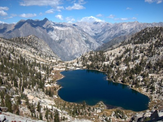
Seven years ago I thru-hiked with Buzz Burrell the Sierra High Route, which parallels the crest of the High Sierra between Sequoia-Kings Canyon National Park and Yosemite National Park. Its 200 miles represents less than 1 percent of the total miles that I have hiked, yet the experience proved to be one of the most influential: it revealed to me the grander sense of adventure when off-trail. …
A few months ago in “Short is the new long,” I wrote vaguely about my future backpacking plans. Rather than single expeditions lasting multiple months and covering thousands of miles, my emerging interest is shorter routes that showcase a single topographic feature like a mountain range, watershed, or canyon system. Not only are such routes more practical for a husband and home-owner, but they can sustain a higher level of overall awesomeness than longer trails or routes, which invariably include mind-numbingly boring “transition” miles between worthy sections.
Today I’m thrilled to introduce my first original project, which I stitched together over two summers. The 124-mile Kings Canyon High Basin Route circumnavigates the upper watershed of California’s Kings River and is encompassed entirely within Sequoia-Kings Canyon National Park. It’s an instant classic, and I believe it’s at least on par with the original, Roper’s Sierra High Route, for being the finest route in the High Sierra. …
Two-thirds of the Kings Canyon High Basin Route — specifically, 82 of its 124 miles — is officially off-trail. Five of these segments are longer than 10 miles, and one extends for 21! Save for the very beginning, very end, and 11 miles on the High Sierra Highway (aka John Muir Trail) in the middle, its on-trail miles are typically on lightly traveled pathways deep in the backcountry. …
Utah Canyons STORE & COFFEE SHOP should be your first stop on arriving in Escalante, Utah.
We have fuel, custom annotated topographic maps, guidebooks and “desert tested” gear to help you fully enjoy your remote day-hike, canyoneering adventure or epic backpacking trip. …
Get local information on what hikes are best while you are there.
… we decided to stop and check out the beautiful Zebra Canyon. The added bonus to this route was tunnel Slot, a very dark tunnel through the sandstone, filled with ice cold water. Visiting these two locations took us 3.5 hours.
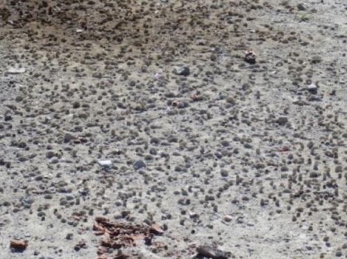
We went as far as we could up Zebra first then turned around and hiked out then up the sandstone to the top of this canyon to look down it. Up top we found tons of moqui marbles in all various sizes. …
After this canyon we hiked straight towards Tunnel Slot by taking the obvious cut in the terrain connecting the two canyons. Arriving at the top of Tunnel we found that it was full of water whose depth was hard to determine and ended up being about thigh deep. Tunnel Slot is a very short oddity of a canyon due to its shape but was fun to visit. It also had the coldest water I think I’ve ever felt in my life. The short stint in the water, maybe 75 feet made my feet and legs feel like they suddenly belonged to someone else. …
Forget about bears, mountain lions, and murderers –
The last (and only) recorded death from a wild bear in California, Oregon, or Washington? A four-year old girl in 1974. The last hiker killed by a mountain lion on the PCT? Never. The last time a person was murdered on the PCT? Also, never.
4. GIARDIA
5. THE SUN & DEHYDRATION
6. POISONOUS PLANTS
7. BUTT CHAFE
8. BICYCLISTS
9. MOSQUITOS
10. CARS
11. UNLEASHED DOGS
12. MAN-MADE HAZARDS (Asbestos, high voltage cables, and unexploded military ordinances are just a few …)
13. THE BOOGIE MAN (psychological distress)
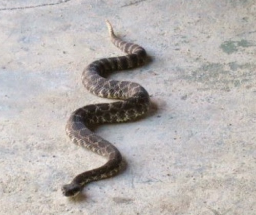
14. SNAKES
15. COWS
16. SNOW
17. POOP
I like to – when I can – face uphill. Hang on to a log or my backpack for balance. And dig the hole AFTER the deed. Eventually pushing dirt and faeces into the hole.
If possible, I cover the grave with the biggest, flattest rock I can find.


 AT A GLANCE