Langtang Trek – day 4

Trip report by site editor Rick McCharles

Langtang Village 3430m to Kyanjin Gompa 3830m

We stayed at the Tibet Hotel in Langtang. But all teahouses in any given location are near identical. It really doesn’t matter which one you choose. Cost and quality are the same.

As usual, I waited until the mob of trekkers, porters, pack animals and guides cleared out of the village. The last thing I want trekking in the Himalaya is rush hour.

I sipped milk coffee and enjoyed the morning sun waiting for trails to clear.

P1310953

These Himalayan villages are interesting. Especially after the tourists have disappeared in the morning.

P1310956

The stupendous wide Langtang valley runs east-west, parallel to the Tibet border, enjoying a lot of sun.

P1310976

A highlight for me are the many different grazing animals, especially the Yaks.

P1310977

Long, long mani walls and many stupas remind you that this is Buddhist Tibet not Hindu Nepal.

P1310988

In 2014 another one of these superb bridges was completed.

P1310991

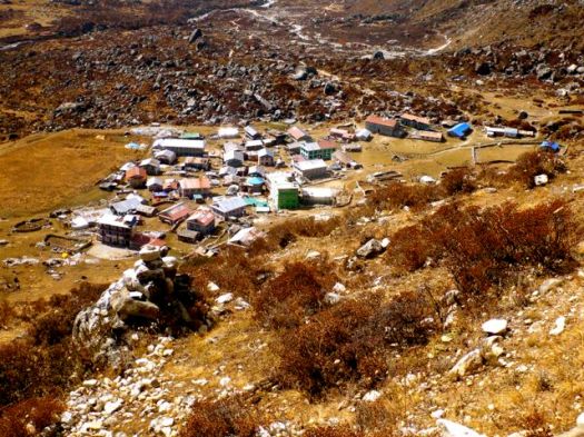
Kyanjin Gompa. End of the line for many Langtang trekkers.

P1310997

I caught up with my group for lunch. Egg noodle soup with extra egg and egg noodle chowmein.

P1320003

No meat is sold in Langtang valley. The chickens are here strictly for eggs. Yaks strictly for milk and cheese.

Up, up, up right after lunch.

P1320007

We would “sleep low, climb high”. Acclimatization paramount.

P1320009

There are stupendous views looking towards Tibet. Monstrous glaciers.

P1320023

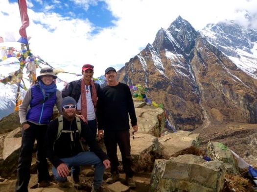
Kevin and Delphine with their guide BJ. He led my Manaslu Circuit trek last year. And I hope to trek with him again in future.

P1320029

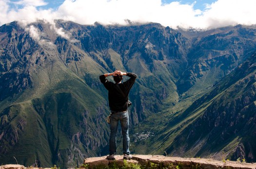
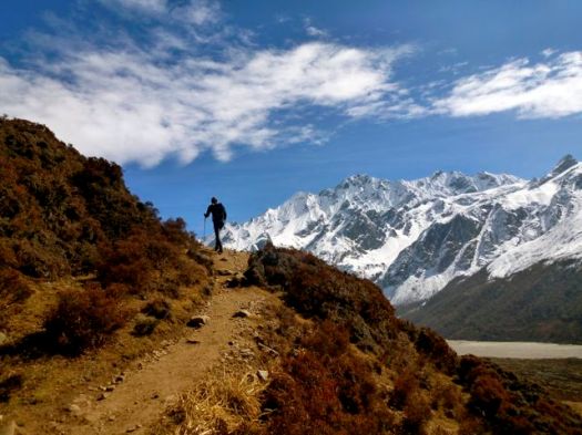
We could have stopped here at the first viewpoint. But the ridge walk up was too tempting.

P1320032

P1320042

Vistas got better and better.

P1320040

P1320070

Photos give you just a hint of the magic of the Himalayan light. You feel you can touch the highest mountains in the world, the relief and contrast so striking.

P1320056

About 45min up from the first prayer flags we reached the summit of Kyanjin Ri at 4850m. I left a Summit Stone.

P1320066

Prayer flags are believed to have originated with Bon, which predated Buddhism in Tibet.

P1320065

P1320063

BJ knew a different and easier way down. We descended via this sandy watercourse.

P1320075

That night we learned a guy at our lodge on his own had tried a different descent on Kyanjin Ri, getting lost. Sometimes it’s nice to have a guide. 🙂

On the return we visited Kyanjin Gompa itself, sadly now disused. The monks long gone. Only about 3 times a year do some return for festivals.

An elderly woman unlocked it for a donation.

P1320085

P1320094

P1320092

I was more interested in the food and fuel being stored away for the coming winter.

P1320089

P1320091

By dinner we were tired and had slight headaches. It had been a big day for altitude. Perhaps we pushed it too high. Some on our exact same itinerary were down, altitude sick.

P1320097

The night sky was fantastic.

see all my high res photos from this day

day 0 | day 1 | day 2 | day 3 | day 4 | day 5 | day 6 | day 7 | day 8 | info | … Gosainkund

Simien Traverse, Ethiopia

I’m hoping to do the famed Simien Traverse in early December 2014. I’ll be in country Dec 1-14th. It’s the best hike in Ethiopia, one of the best in the world.

Simien

Click PLAY or watch a some highlights from a 2014 trek on YouTube. It looks spectacular. Scenery and wildlife. Especially the Gelada Baboons.

I’m using the most recent Lonely Planet Ethiopia to start my research.

I plan to fly Addis Ababa to Gondor, buying my ticket when I get to Ethiopia. Spend at least one night in Gondor, acclimatizing, before traveling about 2hrs north to Debark.

map2

The Simien Park Hotel in Debark is reputed to have hot water showers. One night there while I organize my adventure at the National Park Office.

I’m hoping to either join a group headed up or to hire the minimum for a solo trek. That’s one ‘Scout’ (armed park ranger) and one English speaking guide.

No mules. No cook.

The most popular route is 4-5 days to Geech or Chenek and back. I’ll not summit Ras Dashen, the highest peak in Ethiopia.

Leave a comment if you’ve done this trek.

Colca Canyon, Peru

We’ve moved and updated our Colca information page. 🙂

A trip to Colca Canyon is recommended for all hikers, regardless of ability and experience. It offers superb day hiking and immensely popular 2-day trips.

Bruno Iglesias
Bruno Iglesias

Hard core hikers will love a unique 5-day option descending into the canyon then climbing up over a snowy 5100m (16,732ft) pass to the remote and rarely visited Valley of the Volcanos — weird cones & lava formations!

AT A GLANCE

  • canyon of the Colca River in southern Peru
  • depth of 4,160m (13,650ft) more than twice as deep as the Grand Canyon

Yeti Adventure Films nailed the feel of Colca in this cute edit. 🙂

Click PLAY or watch it on YouTube.

details on our Colca information page

how did the rodent get in my car?

I parked overnight at the Cheakamus Lake trailhead near Whistler B.C.

Vandals have been known to break into vehicles here, so I was careful to lock up tight.

On my return, I found that a bag of sunflower seeds had been worked over by some kind of critter.

rodent in the car

There’s a slight risk of Hantavirus, of course. Not good.

I’d never before heard of rodents gaining entrance to a locked car. Leave a comment if you’ve heard of this in the past.

related – How do you deter mice from automobiles?

trek the Dientes Circuit in Patagonia

We’ve moved and updated our Dientes information page.

AT A GLANCE

  • circumambulate the jagged spires of Cordon de los Dientes
  • out of Puerto William, Chile, on Isla Navarino (pop. 2,262 last time we counted)
  • recommended 5 days, 4 nights
  • world’s most southerly major hike?

Why We Like This Hike

  • great views, most of the trek is above the treeline
  • vista over the islands making up Cape Horn (about 150km south)
  • condors, guanaco & beaver may be seen
  • it’s close to Paine & Fitz Roy, our favourite hikes in Patagonia
  • no risk of altitude sickness
Radek Tezaur

 Check the rest on our Dientes information page.

coast-to-coast Madagascar

The plan is simple – to be a part of the world’s first group to walk across the northern part of the island from east to west, entirely on foot, a distance of almost 400 km, in the seemingly impossible timeframe of three weeks. …

madagascar10a-750x498

Days pass by as we trek west. We camp in rural villages – usually on patchy football fields where, night after night, hundreds of curious children and adults alike surround us, amazed at the presence of a ‘Vaza’, a white ghost – the Malagasy term for westerners. They haven’t seen many before. In fact, in this part of Madagascar, away from the tourist trail in the south, the last foreigners that have entered the foothills of the Tsaratanana were the French army in the late 1940s and occasional mineral prospectors in the 1970s. …

madagascar11a

At exactly the half way point of the journey, after almost two hundred kilometers of uphill slogging, we reach the summit of Maromokotro, Madagascar’s highest mountain. …

madagascar2a-750x421

read more – Adventure Travel: Madagascar

(via Hiking in Finland)

Mt Townsend Trail, Washington

trip report by site editor Rick McCharles

8.2 miles round trip

In 1792, as Captain George Vancouver was exploring the Puget Sound, he named a large, protected bay Port Townshend. The h was eventually dropped.

One of the most hiked summits in the Olympics, and it’s easy to see why this peak is so popular. Easy access, a long hiking season, and unparalleled views of Puget Sound and the eastern half of the Olympics give Mount Townsend quite an edge. Of the three trails leading to its summit, Trail No. 839 is the route most taken. …

Most hikers intent on reaching the 6280-foot open summit opt to begin their journey from the upper trailhead. This saves 1.2 miles and 600 feet of elevation gain, but at the expense of missing a beautiful old-growth forest and Sink Lake, a small body of water that causes tumbling Townsend Creek to disappear. …

Washington Trails Association

I did start from the upper trailhead. 4 miles at an angle of about 20 degrees was challenging enough.

P1300317

Perfect weather, the only surprise were solo tent caterpillars dangling down across the trail at lower elevations.

P1300319

It took longer than expected to clear the tress and get to the gorgeous views.

P1300325

Up top, late in the afternoon, it was just me and these guys. 🙂

P1300327

I decided to go for a scramble down this ridge, eventually having to retrace my steps.

P1300320

Somewhere on that ridge, I left a Summit Stone.

I didn’t get back to the parking lot until 7:30pm, much later than I had expected. My trail running down hill was not all that speedy.

more photos

map

• another trip report – Mount Townsend Trail #839