Kalalau Trail, Nā Pali Coast, Hawaii

We’ve added an information page for Kalalau, one of our top 10 coastal hikes of the world.

AT A GLANCE

800px-Real_Kaui_Panorama1

You can day hike it, as Jack did.

2406806964_c19e3c748c_z

Or hike 22 miles return over several days.

by Serban Dumitrescu

Click through if you mike like to do this adventure yourself one day. 🙂

Kalalau Trail information page

South Coast Track, Tasmania

We’ve added an information page for those wanting to organize for the famed South Coast Track in Tasmania, one of our top 10 coastal hikes in the world.

World → Austalasia → Australia → South Coast Track

The South Coast Track is a challenging walk in a region of Tasmania exposed to harsh weather conditions. There are no huts along the track. Track conditions are often difficult. Walkers must be fully self-sufficient, well-equipped and experienced.

New Harbour Lagoon

TasmaniaAT A GLANCE

  • surreal, unique Tasmanian seascapes
  • entirely within Southwest National Park
  • flying in, walking out, the standard route is 82km (51mi)
  • 6-8 days Melaleuca to Cockle Creek
  • best months December to March

tastrails SCT map

South Coast Track information page

Olympic National Park – planning for June 2015

I’ve enjoyed many great hikes on the Olympic Peninsula over the years. Weather is a huge factor. When it’s not raining, the Olympics are paradise. 🙂

Here are a few of my photos from the past.

pack Olympic

wild flowers

deer Olympic

I’m planning to return June 22nd 2015.

I’ll decide when and where to hike based on the weather forecast. Plan A is to start with Cape Alava – Rialto Beach, the “Shipwreck Coast“. There are many other options, of course. 🙂

Rialto Alava

Shipwreck Coast, Olympic Peninsula, Washington

I’m planning to do the Shipwreck end of June 2015. 🙂

It’s 20 miles from Rialto Beach to the Lake Ozette Ranger Station. From Lake Ozette, you can tack on another 15 miles from the ranger station to Shi Shi Beach. …

… wind-and-wave-hammered, isolated, and strewn with massive logs and giant strands of kelp. All that makes it one of the most unique backpacking adventures in the lower 48: a wilderness beach hike untrammeled by resort homes and boardwalks. …

The beachscape, which is part of the 2,408-nautical-square-mile Olympic Coast National Marine Sanctuary, is full of life and always changing: low tides expose tide pools filled with orange and purple stars, urchins, sea anemones, and other intercoastal life. …

National Geographic

Shipwreck

Expedition Alaska Adventure Race

I’m planning to volunteer for Dave Adlard’s NEXT expedition race. Social media. Photos. Video.

June 28th – July 4th, 2015.

Over almost 7 days, teams will undertake a 340 – 600 km (200 – 350 miles) expedition over some of the most beautiful, epic and challenging terrain on Earth.

Racers will use a map, compass and their own wits to navigate their way over a (mostly) unmarked route by mountain biking, rafting, paddling, trekking, canyoneering, coasteering, glacier travel, orienteering, trail running, fixed ropes, and a few other surprises through the amazing expanse of Alaska’s Kenai peninsula!

expeditionak.com

Expedition Alaska

High Coast Trail, Sweden

The High Coast (Swedish: Höga kusten) is a part of the coast of Sweden on the Gulf of Bothnia

… since the last ice age the land has risen 800m, which accounts for the unusual landscape with tall cliff formations. The High Coast is part of the Swedish/Finnish High Coast/Kvarken Archipelago world heritage site (the High Coast was extended with Finnish Kvarken areas in 2006). …

The Höga Kustenleden is a 128 kilometer long trail along the High Coast. …

Hiking in Finland has a superb trip report of a late Autumn adventure:

The scenic trail passes through villages & towns, along the coast, through the forest and a beautiful National Park and if you have a free week makes for a great walk along the Swedish coastal hills. …

Högakustenleden – the High Coast Trail

16237534596_140c3a9356_b

Beautiful photos. 🙂

Click PLAY or watch a 3min clip taken during milder weather on YouTube.

Long Range Traverse, Gros Morne

Gros Morne National Park is a world heritage site located on the west coast of Newfoundland. …

Gros Morne is a member of the Long Range Mountains, an outlying range of the Appalachian Mountains, stretching the length of the island’s west coast. …

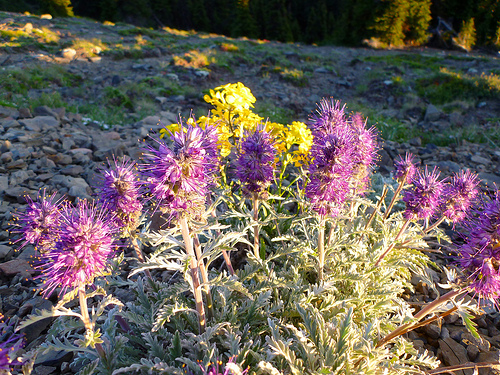
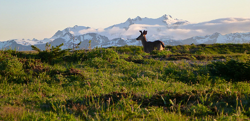
Hiking the trails is a popular activity at Gros Morne. There are about 20 marked day trip trails, exploring coastal and interior areas of the park. …

The interior of the park can also be accessed, notably through the multi-day Long Range Traverse between Western Brook Pond and Gros Morne Mountain. …

Leigh McAdam:

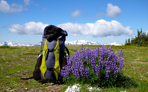
Before you even get a whiff of the Long Range Traverse, the premier backpacking trail on Canada’s east coast, you must pass a serious navigation test and get a full orientation by staff at the Gros Morne National Park Visitor Center.

The navigation test is nothing to sneeze at. You must understand declination and know how to take a compass bearing from the map. Although you can take along a GPS, and it might help in foggy situations, it’s your map and compass skills that are of utmost importance. It’s the only place in Canada that I am aware of that requires you to pass a navigation test. I guess what happened in the past, is too many backpackers set out, only to get lost – as there is no marked trail – and ended up needing a rescue.

Hike Bike Travel – Backpacking the Long Range Traverse in Gros Morne NP: Day 1

campsite night 1

Long-Range-Traverse-462hsrs

Day 2

Day 3

Day 4

Long-Range-Traverse-481hsrs

NEW – Three Capes Track, Tasmania

The official website says it will open November 2015.

The Tasmania Parks and Wildlife Service’s largest and most ambitious track project, the Three Capes Track, will be a world class, multi-day walking experience on the Tasman Peninsula along a track up to 82 km in length.

The track will showcase Cape Raoul, Cape Pillar and Cape Hauy as well as stunning natural features and scenery including dolerite cliffs and ocean views. …

Parks and Wildlife Tasmania

Cape Pillar Peninsula from the Blade (Photo courtesy of Stuart Gibson)
Cape Pillar Peninsula from the Blade
(Photo courtesy of Stuart Gibson)

You can either walk the route independently or sign up for a fully guided experience provided by a commercial operator.

What will set this track apart from the many multi-day hikes in Australia is the standard of public facilities available. The walk will include huts at up to three sites with mattresses and cooking facilities, reducing the amount of things you’ll need to lug in your rucksack. Bye bye camping stove and fuel, tent and sleeping mattress. After trekking past the tallest sea cliffs in Australia and awe-inspiring ocean views, walkers will be snuggling down on a soft bed.

Lonely Planet – The world’s hottest new travel experiences for 2015

hike Rota Vicentina, Portugal

mapa_secciones211Rota Vicentina is a long distance path along the SW coast of Portugal, between the city of Santiago do Cacém and the Cape of St. Vincent, totalling 350 km to walk along one of the most beautiful and best preserved coast lines of southern Europe. …

It’s easy to section hike. Easy to hike independently. Or sign on with a guide.

The official website is excellent – RotaVincentina.com

Click PLAY or watch a beautiful promo edit on YouTube.