Rota Vicentina is a long distance path along the SW coast of Portugal, between the city of Santiago do Cacém and the Cape of St. Vincent, totalling 350 km to walk along one of the most beautiful and best preserved coast lines of southern Europe. …
It’s easy to section hike. Easy to hike independently. Or sign on with a guide.
Cyprus doesn’t necessarily strike you as the number one hiking destination, but in fact the dramatic scenery, mountains and coastal paths make it a fantastic place for walkers of any experience level. Here are three tried and tested walks you might want to try (though you can definitely find others, and even accidentally stumble on to others whilst finding these!)
photo by Bald Hiker
Aphrodite Trail
Start Point: Baths of Aphrodite
Distance: 8 kilometres. At the utmost peak you’ll reach 370m.
Best for: This hike is for those who are serious about walking; first timers might want to skip this one and head straight into the Baths of Aphrodite or grab some lunch on the terrace. The walk involves some steep uphill climbs, so pack proper walking gear (and don’t even whisper the word ‘flip flops’). Keen photographers will also enjoy this walk as you’ll get some cracking shots over the Akamas Peninsula; there’s definitely satisfaction to come at the end of the struggle with this one.
Time it takes: 3-4 hours depending on how leisurely you’re planning to amble.
Why it’s great: This is renowned as one of the most beautiful trails in the whole of Cyprus.
How to get here: If travelling from Paphos, take bus 645 from Karavella bus station to Polis. This journey takes roughly 50 minutes and leaves on the hour from 8am. From there, change to the 622 to the Baths of Aphrodite. This takes about 30 minutes and again leaves on the hour.
Where to stay: There are loads of stunning hotels – you can check the reviews on TripAdvisor to see which suits!
___
Agros Kato Mylos Nature Trail
Start point: Near the Rodon hotel.
Distance: 6 kilometers.
Best for: Seeing vineyards, orchards, and the rose bushes which the small town is famed for – the annual rose festival takes place in May when thousands of roses are picked to make rosewater. There are also feasts, dances, and ceremonies that attract a lot of tourists during this month. This walk is average in terms of difficulty, but is easier than the other two listed, if a little dangerous and slippy at points.
Time it takes: 2 hours.
Why it’s great: Agros is really tiny, with a population of only around 800. This means you can really escape the tourist clap-trap here and get back to nature without touts trying to sell you knock off souvenirs or overpriced restaurants. The locals are warm and welcoming, and you’ll get a taste of what life is like in rural Cyprus whilst gobbling down some of the most glorious food on the whole of the island. The locals have a lot of traditional syrupy sweets which are also worth a try.
How to get here: 90 minutes from Pathos International Airport – so if you’re not adverse to the idea, rent your own car and drive (there’s not so much in the way of public transport in this area)
Where to stay: Given the size of the place, hotels are few and far between, but you can check out reviews for a few of them here. Rodon is popular with people around Greece who like to get out of the city at the weekends, or for people in the area looking for a great dining experience. The name means ‘rose’ and has added considerably to the economy of the region!
___
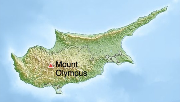
Troodos Trails: Artemis
Starting point: The start is at a small brown hut on the road leading up to Chionistra (Mount Olympus). Take the narrow track immediately to the left of the brown hut (do not follow the signs which suggest it’s the other way – it’s all lies at that point!)
Distance: 7 km. 1850m altitude.
Best for: Great views! This walk is recommended for experienced walkers who are prepared for the rough terrain, or just holidaymakers who fancy a scenic walk and aren’t scared of putting in a little legwork and being careful on the rocks. (Or those with super dodging skills if you decide to go in winter – you might get knocked off the path by passing skiers).
Time it takes: 2-3 hours.
Why it’s great: Goes around Mount Olympus in the Troodos Mountains. This site is often home to weddings, wine lovers coming for tasting sessions and skiers during the winter. You can get some spectacular long distance views when the weather is good(on a really clear day in the winter you can sometimes see out to the coast at Limassol). There are also lots of ruins set into the mountain sides. Best to head out later in the season rather than summer, when the flowers will be in full bloom. (Although don’t go too late, because in winter it won’t be a trail so much as a ski slope).
How to get here: This site is really useful if you’re planning on travelling around by bus. Or rent a car – it’s a 1 hour 15 drive from Pathos International Airport.
Where to stay: You can find a write up of family run hotels and more rural retreats here.
The huts are basic. First come, first served. I’ll carry a tent, just in case.
No fees. No registration. Easy access from multiple trailheads means you can resupply en route. Logistics will be easy. It’s coastal and fairly flat – aside from 3 mountain ascents of about 4000 feet.
The soonest I could do all or part of the SCT is summer 2015. Leave a comment if you are interested. This is a terrific excuse to visit the Sunshine Coast of Canada.
One more thing.
There’s a paddling route roughly in parallel with a large section of the Sunshine Coast Trail. From Shinglemill to Canoe Main. Hikers could switch to canoes or kayaks for a break from the trail, or meet up with paddlers at designated campgrounds. Portage is required.
Distance: 5.4 miles round trip
Elevation gain: 1000 feet
Difficulty: Moderate
Seasons: Year round (Update from KTred: Forest service road 1861 access to the trailhead is closed January 1-July 15th, adding several miles of uninteresting gravel road hiking. You could be fined be the Forest Service for being behind the gate.)
The Hart’s Cove Trail starts out by switchbacking downhill through a young coastal forest. Railroad tie steps here help make footing better. …
Dungeness Spit is one of the world’s longest natural sand spits, 5.5 miles (8.9 km) long and very narrow. A lighthouse, the New Dungeness Light, built in 1857, is located near the end of the spit. …
I jogged from a distant parking lot to the entrance, only to be told:
To ensure that wildlife continue to have a place to rest and feed, some recreational activities such as jogging, swimming, and other beach activities are allowed only in selected areas during certain times of the year. …
No jogging. 😦
Instead I ran on west of the Park. There’s a very popular trail on top of the bluffs.
The Superior Hiking Trail, also known as The “SHT,” is a 275-mile (442 km) long footpath in Northeastern Minnesota that follows the ridgeline overlooking Lake Superior for most of its length. …
Facilitating this purpose are 81 campsites spread throughout the northern section of the trail. …
Joy Santee just finished.
Music: Akins Birmingham Boys “I Walked and Walked”
Wilsons Promontory is a peninsula that forms the southernmost part of the Australian mainland …
Most of the peninsula is protected by the Wilsons Promontory National Park. …
A trip report.
… for the northern prom you need to complete a “Wilderness permit application” . Whilst I can understand the need to ensure that hikers in this area can navigate along poorly marked trails (which are often overgrown) ford or swim rivers which can be over head height, navigate trackless swamps but the area is not wilderness, as the there are marked trails and designated campsites. …
We descended to 5 Mile Beach and the occasional trees provided us with some respite from the winds as we descended steeply to Miranda Creek and the campsite. …
Eric Leifer of National Geographic Young Explorers :
Fiordland National Park, tucked away far within New Zealand’s South Island, has the notorious claim to fame as one of the wettest locations in the southern hemisphere; and with a mean annual rainfall of 268 inches …
Throw yourself off the deep end by accepting the challenge of the country’s hardest trail, the infamous Dusky Track, an 84-kilometer route that impossibly forces its way through this impermeable landscape. …

Rota Vicentina is a long distance path along the SW coast of Portugal, between the city of Santiago do Cacém and the Cape of St. Vincent, totalling 350 km to walk along one of the most beautiful and best preserved coast lines of southern Europe. …