#5 best hiking town is …

Chamonix, France

I spent a couple of weeks hiking out of the mountain town in 2009, astonished at how down to earth and welcoming it is for outdoor sportsmen from around the world.


photo – ptpotts

Chamonix-Mont-Blanc or, more commonly, Chamonix … was the site of the 1924 Winter Olympics. The commune’s population … around 9800 …

… Mont Blanc, at a height of 4810 metres, is the third most visited natural site in the world …

… well known and loved by skiers and by mountain enthusiasts of all types. …

Chamonix is located 80 km southeast of Geneva, Switzerland …

Chamonix Place Balmat

More interesting photos tagged Chamonix.

You can hike out of town in any direction. And be blown away by wonderful mountain vistas. Here I am just above town on a trail run.

fit hiker in the Alps

The most famous “best hikes” in the region are:

• Chamonix to Zermatt – Walkers’ Haute Route <my trip report> (top 10)
• Tour of Mont Blanc (TMB – top 10)

More best hikes in the Alps.

Best time to hike is late June to early October.

#8 best hiking town is …

El Calafate, Argentina

All hikers plan, one day, to travel to southern Patagonia. Towers of Paine photos entice.

And anyone who hikes Paine, should also hike Fitz Roy, Argentina.

Hikers have a choice to base themselves out of Puerto Natales, Chile or El Calafate, Argentina. Though you may find yourself stopping in both, El Calafate is the better choice.

El Calafate is a small town in Patagonia, Argentina. …

… an important tourist destination as the hub to visit different parts of the Los Glaciares National Park, including the Perito Moreno Glacier (one of the most visited in the world) and the Cerro Chaltén and Cerro Torre.

… In the last census 6,143 permanent residents were counted

You could argue that El Chaltén, Argentina’s “national trekking capital“, about 220km from El Calafate, is an even better base town.

On the other hand, there are large grocery stores like Diarco in El Calafate. The shops in Chaltén in 2019 were still very limited. We couldn’t get instant mashed potatoes in Chaltén, for example. Pick up your provisions in Calafate.

And Calafate is about half way between Paine and Fitz Roy.

More interesting photos tagged El Calafate, Argentina.

More information on Wikitravel – El Calafate.

Our favourite hike hikes out of El Calafate:

• Paine Circuit (Torres del Paine), Chile

• Huemul Route, Fitz Roy, Argentina

• Around Monte Fitz Roy (Los Glaciares), Argentina

These are the most famous, but there are many more “best hikes” in the Patagonian Andes. Ground transportation is the biggest challenge in this part of the world.

Best months are December to March.

trekking Dientes, Patagonia

Ace and Patricia hiked the most southerly established major trail in South America, part of the Circuito Dientes de Navarino.

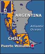
I read their trip report with interest. I’d once traveled to Punta Arenas intending to do Dientes, but ran out of time to arrange the tricky transportation to the Puerto William, Chile, on Isla Navarino. That’s the jumping off point for Dientes.

Ace and Patricia ended up taking the Zenit’s 15 passenger boat from Ushuaia, Argentina, to Puerto Williams. And later found a flight back on a 3-seater plane.

Extreme weather in this most extreme part of the world makes all manner of transportation a gamble.

Was it worth it for Patricia?

Yes.

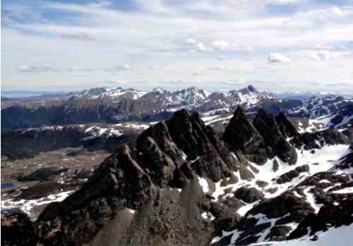
… We reached the dip between the peaks and were rewarded with breathtaking views of the spiky Dientes and across Isla Navarino to sets of islands beyond. It was a clear day and we saw the islands of Cape Horn. It was definitely the highlight of the trip. …

Painted stones & cairns mark the trail. Unfortunately many of those were covered by snow.

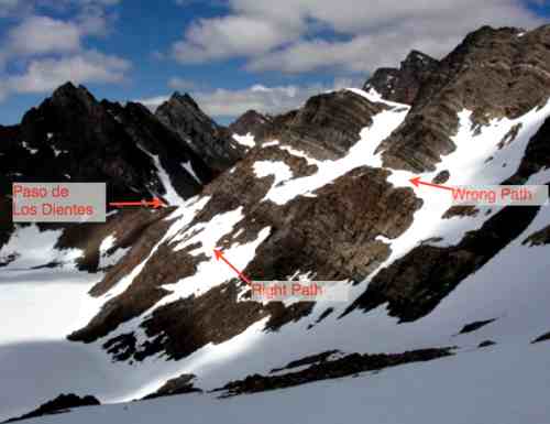
Everyone has navigation challenges on Dientes, this adventure more than most. Their goal on day 2 was to cross Paso de los Dientes. The guidebook said to “stay high”. … They stayed too high, eventually having to backtrack when the risk of a mini-avalanche got too great.

If you’ve ever dreamed of hiking the teeth of south South America, download Patricia’s Trip Journal. (PDF)

Check our Dientes information page.

Mt Asgard, Baffin Island – the movie

More rugged and remote than the Himalayas.

The Asgard Project – OFFICIAL Climbing Teaser – Posing Productions

Click PLAY or watch the trailer on YouTube.

… objective to make the first free ascent of the west face of Mt Asgard on Baffin Island. Like that’s not an awesome enough feat in itself the journey there will be pretty special involving training trips to Riglos in Spain, Brento in Italy and Yosemite in California! …

Posing Productions

The film crew hiked in to this location in 5 days.

(via The Adventure Channel)

Triple Crown of Waterton, Akamina

by site editor Rick McCharles

Day 2 of my last ditch attempt to complete the Triple Crown of hikes in Waterton National Park.

(If you missed it, click back to Day 1.)

I’d have to complete Akamina Ridge first, then go back to finish Alderson-Carthew:

Akamina Ridge is a round trip hike of about 20km and the maximum elevation is 8600ft. A lollypop loop trail.

Your journey starts at the Akamina Pass trailhead about 1km from Cameron Lake along the Akamina Parkway. The trail starts out on a gentle slope. About 2km in you enter Akamina-Kishinena Provincial Park, shortly after this point and once you have taken the necessary pictures at the “Welcome to BC” sign …

Akamina Ridge hike, Waterton

… you will have the options to go to either Forum Lake or Wall Lake to continue your hike. The Ridge is accessible from both but the difficulty upwards vary. This is where the trail really begins. The choice varies from the constant but relatively steady uphill trail to and from Forum Lake or the gentle long trail to Wall lake and then the sudden steep rise all the way up to the trail. …

To save time I tented on the trail.

Akamina Ridge hike, Waterton

Like most other hikers, I chose to climb up the Forum Lake trail to access the ridge, descending to Wall Lake. That’s safer I was advised at the Park information centre.

Here’s Forum.

Akamina Ridge hike, Waterton

The ridge was signed. No problem.

… until I got to the final scree approach. The trail was covered with wind swept snow. I literally had no idea how to get on top of the ridge, having never done this hike before.

Blast!

Instead I made a frantic scramble back down the mountain to Wall Lake, thinking I would reverse direction, if possible.

That turned out to be a mistake. Time consuming and somewhat dangerous.

I was quite relieved to get to the bottom without injury.

Akamina Ridge hike, Waterton

And I’d run out of time.

I dropped a Summit Stone at this cairne, far side of the lake.

Akamina Ridge hike, Waterton

And turned back.

My Triple Crown attempt for 2010 was over.

Akamina Ridge hike, Waterton

Too bad.

Next year.

Andrew Skurka 4700mi in the North

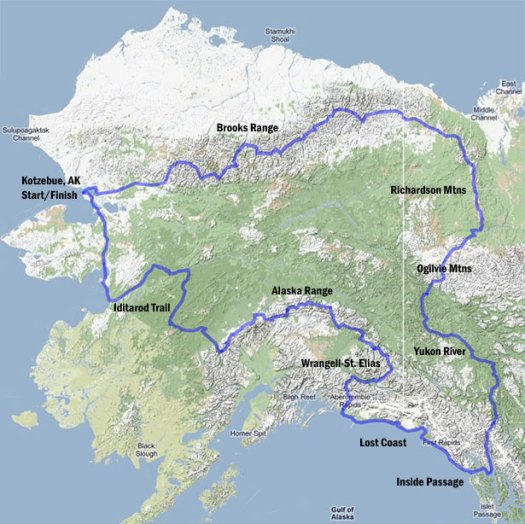
Sunday, Sept 5th Andrew Skurka completed 4,700mi in 7 months via skis, foot, and a packraft.

Congratulations.

CheapTents.com: What part of the Alaska-Yukon route provided the most spectacular scenery?

AS: The Alaska Range was the most majestic, and my route through it was spectacular. The Chugach Range is equally impressive but my route was further away from it. The Brooks Range is a backpackers’ dream, especially Gates of the Arctic National Park in the Fall.

read the interview – Adventurer Andrew Skurka on his latest expedition

(via The Adventure Blog)

HIKING – Samuel H Gardner the next Skurka?

Andew Skurka is the most accomplished “hiker” of all time.

Andrew’s 6,875-mile Great Western Loop ranks as the #1 thru hike of all time, in my books.

He’s currently doing Alaska / Yukon, 4,700 miles in 7 months via skis, foot, and a packraft.

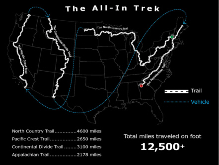
… Now unknown Samuel H Gardner is setting out in January on a 12,500mi proposed route he calls the “All-In Trek”.

… end-to-end and back-to-back the four longest trails in the U.S. This involves starting the trek on snowshoes on January 1st on the North Country Trail Westbound, then the Pacific Crest Trail Northbound, then the Continental Divide Trail Southbound and finally hiking the Appalachian Trail Southbound. It is my intention to hike the 12,500+ miles continuously in one trip. It is my goal is to finish in one calendar year. However, the four trails have never been hiked back-to-back before so the “journey” is more important to me then the speed record. Simply, I intend on walking quickly to avoid most of the deep snow in the mountains. …

Ambitious, or what?

I’m not sure even Skurka would attempt it.

That comes from an excellent interview on CheapTents.com.

Gardner’s official website is called – the INITIATIVE

(via The Adventure Blog)

another June Tour de Mont Blanc

Richard Tulloch’s amusing summary of his early season trek on one of the very best hikes in the world.

The full circuit of Europe’s highest range is some 170km long and takes about 60 hours of walking. Most people do it in 8-12 days. ….

It’s staggeringly beautiful terrain – or is that my pack making me stagger? …

Doing it in June is risky:

… We’re in a bit of trouble on our hike, high on Switzerland’s Col d’Emaney. It’s blowing a gale and there’s frozen snow on a treacherously steep slope. My Dutch companions are carrying ice axes, but I’m not roping myself to anyone who learned their mountaineering below sea level in Amsterdam. …

Click through to see how they got out of this situation …

TOUR DE MONT BLANC – the Swiss section

And while you’re there, click through on HIKING for Richard’s adventures in New Zealand, Australia, Europe and more.

→ besthike TMB information page

Wonderland Trail in 63hrs

Dr. Jeni McNeal and Dave Adlard, founding members of Team Adventure Sports Week, along with an unofficial support crew of Rick McCharles of BestHike.com completed the 94 mile/47,000 feet elevation Wonderland Trail in 63:03, June 25 – 28.

The two carried their own gear, and took only a few hours sleep time in completing what some have said is one of the fastest unsupported, July circumnavigations yet. Almost 10% of the trail was still snowed in, requiring route finding and snow travel. Most hikers completing the trail require 8 – 12 days to finish.

They climbed and descended more than 20 peaks on the famously difficult trail, with elevation changes equivalent to climbing and descending Mt. Rainier from Paradise Visitor Center almost three times. They also encountered bears along the trail.

The two burned almost 33,000 calories each, and drank more than 50 liters of fluid total in temperatures ranging from 33 – 89 degrees.

Their journey began at Reflection Lake on July 25 at 10:40 am, and finished at 1:43 am on July 28.

“This was one of the most psychologically and physically demanding tests I have done since starting Adventure Racing,” said Adlard. “This is a really tough trail that demands a lot from all participants.”

The trail is notoriously uneven, with steep, overgrown and narrow sections that make forward progress difficult in many places.

Team Adventure Sports Week is training for the five day Desert Winds Expedition race in Lake Mead, Nevada, Sept 18 – 25.

Read Dave’s detailed trip report & gear list (PDF)