Construction began on the trail in 1963 and the area was designated as a National Recreation Trail in 1982. There is a self-guided interpretive tour along the 3.3-mile (5.3 km) trail.
Summit of Mineral Ridge, 2,400ft (730m). Elevation gain is 600ft (180m).
We hiked it January 3rd after a snowstorm. With a 5yr-old. Late in the afternoon, slipping and sliding back to the trailhead in the dark.
A bit more adventurous than usual. 🙂
Here’s a more typical lake view from the ridge.
americantrails.org
Each winter from November through February a migrating population of up to 150 bald eagles visit the area to feed on spawning Kokanee salmon. An interpretive viewing program is offered annually from Christmas through New Years during peak migration.
Tom Mangan tipped us off to this well loved day hike.
The trail leads through the spectacular Parque Nacional Alejandro de Humboldt (Alexander von Humboldt National Park), which UNESCO recognizes as “one of the most biologically diverse tropical islands sites on earth.” Careful where you step: you will pass some of the world’s smallest vertebrates on your way to the El Majá Waterfall, which cascades over 82 feet.
The trail begins at the first narrow section of the Santa María River …
Your hike will take you to the source of the Santa María River—El Majá Waterfall, more tban 82 feet (25 meters) high—where you can rest in the shade before treating yourself to a refreshing dip.
Duration: 5 hours
Distance: 4.3 miles (7 kilometers)
We were up before the dawn, wanting our best chance of success climbing Mt Bwahit.
Our guards had slept outside beside the tents, despite the cold.
The day before our arrival a young Swiss couple had had their daypack stolen. Cameras, money … passports. 😦
It happens all over the world. It happens here, but not very often. Best guess was that one of the mule drivers had grabbed it. Might have been a young shepard boy, though they are chased out of Camp right quick.
I had my valuables strapped to my waist in a passport case, as always.
Our guide had said that our best chance to see Walia Ibex would be this morning. We weren’t disappointed. We saw a number up on a ridge. And later down by the road. They are not shy.
… only about 500 individuals survived in the mountains of Ethiopia, concentrated in the Semien Mountains, largely due to past poaching and habitat depletion. If the population were to increase, the surrounding mountain habitat would be sufficient enough to sustain only 2,000 ibex. The adult walia ibex’s only known wild predator is the hyena. …
I was still feeling weak though I had not lost my dinner from the previous evening.
I’d not slept much. Happily, as we climbed, I seemed to get stronger.
Though we ascended about 800m in less than 3 hours, it wasn’t all that cold. The sun helps for sure. We added and removed layers frequently.
Disappointingly, the road winds up close to the top of the mountain. At times we walked it.
There’s not much traffic, of course. Clouds rolled up the escarpment early. We’d need to reach the top before the clouds did.
We were very surprised to see snow on the top.
This is one of the few spots in Africa where snow falls regularly.
Nadine found snow in Africa
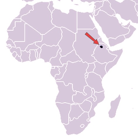
Mt Bwahit (4430m) is the third highest mountain in Ethiopia and the 13th or 14th highest in Africa.
This is as far as we got following the escarpment. But the road continues to Mekane Berhan, 10km past the Park.
In fact you can keep going 17 days all the way to Lalibela, if you like.
Nadine turns back. She’ll be reunited with her husband later in the afternoon.
Neither Nadine or I felt many altitude symptoms. Lucky. She gave some medication, on the trail, to one of the other hikers who was feeling rotten.
Obama is wildly popular in Africa though most distrust the American government.
We saw many more baboons on the descent. We’d left too early to see them on the way up.
The decent was quick. Psychologically, I was ready to go. The Simien a success.
In most high mountains lammergeier (bearded vulture) stay far away from me. But here they float right over your tent. After many attempts, this was the best photo I got. They have up to nearly 10ft (2.83 m) wingspan.
Here’s Josh’s best photo.
In Ethiopia, they’ve become more tolerant of people, now common near trash piles on the outskirts of small villages and towns.
We saw wild chickens on the way down, too. Nur told us that when he was a shepard, age-5 to age-10, he loved to try to catch one for dinner.
Heading out, I risked eating lunch.
Nadine was the one of the few hikers who completed ALL the original planned itinerary. But she was ready to head back to Gondor.
It’s a long, bumpy ride back to the Park gates. The roads are bad even in a Toyota Landcruiser.
The closest good hospital is in Dabark. If you crash like this 😦 … they have an ambulance. Another ambulance, I mean.
Rich tourists from the highest lodge in Africa take a short day hike to see baboons. Or do a tourist ride. Meh.
We tipped around 10% of our tour cost, aside for the cooks who got almost nothing. If the clients get sick, the cooks didn’t do the job.
I suggested to Mohammad, a super guy, that he and the other cooks put a big bottle of alcohol gel on the dining tables. Every time. And to ask cooks and assistants to use it non-stop while preparing food for foreigners.
About half of the hikers I spoke with had stomach problems. Clearly the cook house is not sanitary enough. Cooks work together. If one has dirty hands, it’s possible that all the food will be infected.
When we arrived at the Four Sisters restaurant in Gondar that evening, to celebrate, there was a large bottle of alcohol gel on the table. But don’t expect to see one on a Simien trek any time soon. Inertia is great in Africa.
I’ll suggest to future hikers that they consider bringing their own stove, cook their own food.
Thanks to Nur and Halie, childhood buddies, who are still working together. Nur Hassan is Coordinator for SimienMountainsTour.com. I’ll be recommending them.
Our cost was $1000 for 3 people for 4 days, all inclusive. The lowest price I heard quoted was $250 each for 7 people in one group.
But the sky was blue. People keen to get an early start. This would be the best day of the trek.
I love these high altitude grassy plateaus.
Vegetation changes significantly with altitude. Giant lobelias dominate the landscape from here on in.
Nadine likes what our guide called Everlast, too. This high altitude plant blooms year round.
The heart of the mountains. The central viewpoint of the Simien traverse.
It’s a bit of a scramble.
It’s from here that some see similarities with the Grand Canyon. Our trip organizer, Nur, joked that Simien is more of a Green Canyon.
In fact, only South Africa’s Drakensberg were formed in the same manner. That’s the best comparison.
Spanish Moss. Old Man’s Beard.
When it’s dry, the trails are easy walking.
There’s always an EMERGENCY horse waiting. Many fall victim to symptoms of altitude sickness. There are always people selling knickknacks. Their starting price for bartering is usually $8. For anything.
We stopped for lunch at yet another fantastic cliffside viewpoint.
The cold encouraged us to get moving again. This is 4000m (13,000+ft).
I love best the sections of trail walking the escarpment cliff edge.
The drop is typically 600 – 800m. There is one trail up from the lowlands, using ladders. Park Rangers use it.
One of the great treats of a guided hike is having hot drinks ready on arrival.
These are our mule drivers.
We had hardly seen them as they and their beasts are not welcome at Camp. They were astonished and thrilled with a combined $15 tip. This is likely the only hiking trip they’ll get in a year. There are thousands of horses in the Simien, all waiting their turn to carry tents, stoves and sleeping bags.
At every campsite in the world there’s some camp thief looking to eat your lunch. In the Simien, it’s the thick-billed raven.
Atypically, the clouds rolled in.
I felt there was still zero chance of rain. It’s the dry season.
At 5:30pm we headed over to the cliff edge. Waiting.
At 6:10pm the baboons headed for the cliff.
Geladas sleep, when they can, on steep slopes for protection from predators, quite near the Ibex. Baboons have excellent hearing. Ibex excellent vision. Either/or may detect a lurking predator above.
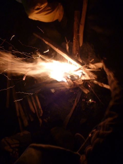
I tried to stay up later around the campfire. But it was too smokey.
My stomach, not perfect on arrival for this adventure, was getting worse.
At midnight I rushed to the filthy toilet with diarrhea.
At about 2am I awoke suddenly, urgent to vomit outside the door of my tent.
Disgusting. But I was too sick and tired to worry about it until daylight.
Early morning the thick-billed ravens squawked around my tent … eating the vomit. It was entirely cleaned up by the time I finally got up.
These birds are the biggest and noisiest ravens I’ve ever seen, unique to this region. They mostly travel in male/female pairs.
Breakfast is normally a highlight of these guided camping trips. But I couldn’t eat today. As a test I forced down coffee and a couple of bites of scrambled egg.
Our gear would ride horseback today. A mob of mule drivers crowded around, hoping they would get work.
There’s a maximum weight / horse. 45kg or thereabouts.
Back to the impressive escarpment walk. Amazing views.
Joshua is smiling here, but his stomach was getting worse by the minute. He and I had eaten fish the evening before. We speculated that it was the fish that made us both sick. Why were we eating fish at 3000m in a land that has little refrigeration?
The vegetation seemed to get more interesting the higher we climbed.
We tried resting at the waterfall lookout, but Josh was getting sicker. He spoke, for the first time, of possible quitting the hike. Not only was his stomach bad, but he was feeling symptoms of altitude sickness.
Climbing back up to the road, we discussed our options. With an interested local audience.
Camp tonight was much higher (3600m) and much more remote. If we continued and Josh was to get sicker, there was no road escape route.
We could try descending and see if he improved, but if we waited too long, there may be no vehicles heading back down this afternoon.
There are a few tourists jeeps each day. And these local people movers.
Finally one of those heading down arrived. Josh made the decision. Hopped up into the truck, paying an absurd $30 for the ride back down to Dabark. Happily one of the hiking guides was in the truck. He promised to get Josh to the mini-bus station and all the way back to Gondar.
It was the correct decision. But it wasn’t easy for Nadine to continue without her husband.
I felt Josh was decided, determined and rational when he scrambled up into the truck.
Later we learned he couldn’t even remember departing. His mind was confused all the way back to Debarq where he was detained for riding illegally in the truck! 😦
Luckily he was finally allowed to take a cab the 2 hours back to Gondar, all the minibuses having departed.
At lunch we were visited by hungry goats.
Baboons live here in conflict with local farmers.
Farmers grow barley. And it was being harvested. Geladas like to eat barley. Each field has a child who’s job it is to chase away baboons.
This lovely Muslim village has 1200 people.
Our scout, Adim, lives here. So he greeted most everyone we met.
My stomach at this point was 90% OK. I’d eaten almost nothing all day. But I was very tired. It was a huge relief when we finally made camp.
I only wanted to lie down for a nap.
But as I dropped my pack, Paul ran over and said: “What are you doing? The Ethiopian wolf is here.”
We rushed to look.
The Ethiopian wolf is native to the Ethiopian Highlands. It is similar to the coyote in size and build …
Unlike most large canids, which are widespread, generalist feeders, the Ethiopian wolf is a highly specialised feeder of Afroalpine rodents with very specific habitat requirements. It is one of the world’s rarest canids, and Africa’s most endangered carnivore. …
Only about 400 survive in 7 different mountain ranges, perhaps 90 in Simien.
Instead of climbing up to the famed sunset viewpoint with Nadine, I crashed in my tent for an hour.
Africa sunsets are the best anywhere, however. I forced myself to get up with my camera.
Nadine got the BIG views up high.
I ate almost nothing for dinner. Went to bed immediately. The indoor campfire was too smokey.
Day 1: Gondar-Sankaber (3250 m), 3-4 hours walking
6:30am Ethiopian coffee
7am pick-up at the (recommended) L-Shape Hotel in the tourist town Gondar. Room about $13 in 2014.
It was an easy 2hr drive to Debarq, the jumping off point for Simien Mountains National Park. Quick stop at the National Park office.
We had breakfast at the Great Work Hotel. Excellent Mango juice.
Our car returned with gear, guide, cook and … personal armed Park Ranger. They call themselves Scouts. A guard is still required for each trekking group in 2014, though these days it’s more of a make work project for the Rangers.
We drove through the Park gates and continued about another hour.
This road is rough. Though it was being improved while we were there.
I’d joined Josh and Nadine, a couple from Edmonton, Canada who have been volunteering in Burundi for the past 2 years.
Here’s our excellent Guide, Adoo.
And our Scout, Adim.
Immediately we headed for the great escarpment.
It’s a long, long way down. About 800m here.
Local people are everywhere. This is a shared use National Park.
We heard that road and power lines being moved further away from the trekking route. I hope that’s true.
Adoo detoured from the cliff when he spotted a group of 200-400Gelada baboons. (more photos)
Geladas are found only in the high grassland of the deep gorges of the central Ethiopian plateau. They live in elevations 1,800–4,400 m above sea level, using the cliffs for sleeping and montane grasslands for foraging. …
Geladas are the only primates that are primarily graminivores and grazers – grass blades make up to 90% of their diet. They eat both the blades and the seeds of grasses. …
They mate in May, have babies in November. Females were very protective of their youngest. Some looked like newborns.
We sat down and let the group graze past us. Some of the toddlers were curious enough to TRY to touch us.
What a fantastic 2 hours. This might be the best wildlife encounter anywhere in the world. It was my best wildlife encounter ever. 🙂
Simien was one of the first sites to be made a World Heritage Site by UNESCO (1978). Due to serious population declines of some of its characteristic native species, in 1996 it was also added to the List of World Heritage in Danger.
The word Semien means north in Amharic. But the name Simien and the word simian do make a good mnemonic for this hike. Geladas are the highilght. 🙂
Elated, we shuffled another hour or so to Camp 1. Talking about the baboons.
poison tomatoes
It’s a very easy half day, yet everyone was huffing and puffing due to altitude.
Popcorn and hot drinks on arrival were much appreciated.
I rested an hour. (I opted to use my own tent. Not the one supplied.)
We headed over to the ridge for the sunset, surprised how cold it was in Africa at night.
Josh got some great pics.
Dinner was impressive: soup, bread, fish, salad, spinach, deep fried banana. I skipped the salad (worried about my health) but tried some of everything else.
We checked the full moon, then retreated to our tents. There was no campfire. I climbed into 2 sleeping bags. The one provided. And my own. Everyone was surprised how cold it was at night in Simien.
Nominated in 2009 to the World Heritage Tentative List, Bale Mountains National Park (BMNP) is a national park in Ethiopia with one of the highest incidences of animal endemicity of any terrestrial habitat in the world. …
Bale Mountains National Park is open year-round although the most popular time to visit is November through April when the rains have stopped. The Park can be reached by private car or public transportation from Addis Ababa. Visitors may choose to trek throughout the Park either by horseback or on foot, or alternatively to visit the Park entirely by car. Treks range from one to 12 nights and travel through all the different ecosystems of the Park. …
Treks range from 3,000m to above 4,000m altitude. Explore all habitats of the Bale Mountains National Park as you trek across the home of the Ethiopian wolf, mountain nyala, giant molerat and Bale monkey. Experience stunning Afroalpine mountains and natural scenery while heading deep into the heart of the Sanetti plateau – a floating land.
Explore vast moorland and discover Afroalpine plants as you camp in the wilderness. Hike amongst rock pinnacles etched out of the lava flows by millions of years of ice and winds, and pass waterfalls and alpine lakes. Camping in the Harenna forest may reward you with a sighting of the elusive animals that live there. Wildlife that can be seen along the way includes the olive baboon, warthog, rock hyrax, Starck’s hare, klipspringer, grey duiker, African wild dog, giant forest hog, leopard, lion and birds of prey. …
The plan is simple – to be a part of the world’s first group to walk across the northern part of the island from east to west, entirely on foot, a distance of almost 400 km, in the seemingly impossible timeframe of three weeks. …
Days pass by as we trek west. We camp in rural villages – usually on patchy football fields where, night after night, hundreds of curious children and adults alike surround us, amazed at the presence of a ‘Vaza’, a white ghost – the Malagasy term for westerners. They haven’t seen many before. In fact, in this part of Madagascar, away from the tourist trail in the south, the last foreigners that have entered the foothills of the Tsaratanana were the French army in the late 1940s and occasional mineral prospectors in the 1970s. …
At exactly the half way point of the journey, after almost two hundred kilometers of uphill slogging, we reach the summit of Maromokotro, Madagascar’s highest mountain. …