My call to cast John Hodgeman as Bryson, and Jack Black as Katz fell on deaf ears.
Robert Redford, 71-years-young, will play Bill Bryson in the film adaptation of the funniest hiking book of all time.

(via Cutter’s blog)

Best hikes, treks, tramps in the world.
My call to cast John Hodgeman as Bryson, and Jack Black as Katz fell on deaf ears.
Robert Redford, 71-years-young, will play Bill Bryson in the film adaptation of the funniest hiking book of all time.
(via Cutter’s blog)
Ken Vande Burgt contacted us by email:
I am a sea kayaker and am concerned about campsites and access after losing recreation sites at Spring Island, Fair Harbour, and Toquart Bay in the Maa Nulth treaty settlement. So far it looks like Nootka Trail is not on the table for other treaties under negotiation, however, it will only stay that way if enough of us make it known that losing the trail won’t be tolerated. Get the word out.
Incredibly, the British Columbia Provincial Government is still sitting on their hands regarding a the popular, unofficial Nootka Trail on Vancouver Island.

source – flickr – Andre Charland
It’s a world class tourist attraction, yet inaction is standard policy for the famously inefficient BC government when it comes to dealing with aboriginal land claims.
Unfortunately, I’m not sure what we can do about it. Petition the Provincial government if you live in that part of the world.
Kraig Becker linked to a great contest for hikers:
Most hikers, trekkers, and backpackers have a particular trail that sticks out to them as being their favorite for one reason or another. Sometimes it’s the scenery or the wildlife they encounter along the way. Perhaps it’s the challenge or the solitude it provides. No matter what reason your favorite trail keeps you coming back, National Geographic Adventure wants to know about it.
The editors over at Adventure are compiling a list of their reader’s favorite trails for a feature on “America’s Best Hikes” which will be the cover story for the April issue that hits newsstands on March 18th. …
read more – The Adventure Blog
I instantly nominated The North Circle in Glacier National Park, Montana. It’s one of our top 10 hikes in the world.
Iceberg Lake in Glacier National Park – flickr – by The Lilac Breasted Roller
Details on how to nominate your favourite American trail on National Geographic.
dbarnett of the excellent A Little Closer to Heaven blog posted his Top 10 Buffalo River Adventures in Arkansas.
Ahh, Hawksbill Crag, the most photographed place in Arkansas. I’m sure you’ve seen the pictures before and dreamed of going there. It’s only a 3 mile hike…what’s stopping you?

Click through for photos and details.
Part I
10. Hideout Hollow
9. Indian Creek
8. Buffalo River Float- Ponca to Carver
7. Fitton Cave
6. Hawksbill Crag
Part II
5. Big Bluff
4. Lost Valley
3. Hemmed-In Hollow
2. Shop Creek Slot Canyon
1. Buffalo River Trail
I’ve always been suspicious of “waterproof socks” for hiking:

Seirus Stormsock Waterproof Sock
Crow confirms “they stink”: Waterproof socks: A bad idea
She likes neoprene socks. As do I.
It was an accident that started me wearing neoprene, actually. I took normal hiking footwear and water walking shoes on the West Coast Trail. And ended up wearing my speciality water shoes with neoprene booties for the entire hike. They were so bloody comfortable.
Sure my feet got “wrinkled”. But a quick rinse was enough to remove the sweat. And they dry in seconds.
Consider this option. One example:
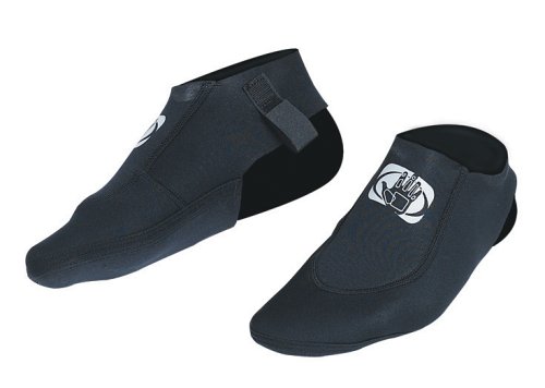
Body Glove Flipper Slipper Neoprene Sock
I don’t wear neoprene on every hike. But my booties were perfect in Paria Canyon.
Any guidebook will tell you yer crazy to consider hiking the Rockies in “winter”. Too dangerous.
Of course that’s nonsense. Tough Canadians ski, snowshoe and even hike year round.
For example, from Ewen on the Outdoor Video magazine site:
Length: Approx 23km
Time: 2 Days
Elevation Gain: 900m total (excluding sidetrip)
Max Elevation: 2330m, (2500m side trip up Saddleback Mt)
Rating: 7/10, some tedious spots though it was overcast and cloudy
Done: End of October 2007
Book: Classic Hikes in the Canadian Rockies, Graeme PoleRoute: From Lake Louise Chateau over Saddleback Pass, into Paradise Valley, up Paradise Valley via river bottom (lower trail), return via Lake Annette and Paradise Valley Junction.
Towards the end of October 2007, UAOC (University of Alberta Outdoors Club) headed to the Lake Louise area of Banff National Park for a late-season two-day backpacking trip. The target: Paradise Valley.
…
We finished off the drive along the Icefields Parkway and registered at the Park Office in Lake Louise. Then, after a quick drive to the trailhead at Lake Louise Chateau, we were ready to get going (you can start from Morraine Lake in summer, but the Morraine Lake road is closed to cars in autumn, winter and spring). Having assessed snow conditions, we decided to leave the snowshoes at the car…a good choice seeing as we barely had to hike through any snow at all! Yet at the same elevation on the Skyline a few weeks before, we had several feet.

… read more – Paradise Valley Backpack – Hiking in Banff National Park
There’s something about Ewen’s trip reports I like. They are succinct, honest and entertaining all at the same time.
We complained May 2006: North Coast Trail, Canada ??
And again in December 2006: North Coast Trail, Vancouver Island – stalled
Now … Joan tipped me off that the NCT will open for the 2008 season. Or most of it, we think. The official announcement is still weeks away.
My Saskatoon hiking friends are looking at their calendars.
From the organizing group on Vancouver Island:
Inaugural Hike: Dave Trebett, Ron Quilter, Shaun Korman, Jacob Blanchard, Ben McGibbon, Ben Pawlett and Dave Parker hiked the North Coast Trail November 4-8, 2007.
A few photos from their report to the Northern Vancouver Island Trails Society:


The full document, called Cape Scott North Coast Trail – Progress Report, is available as a PDF linked from the Northern Vancouver Island Trail Society.
Similar best hikes nearby:
West Coast Trail Nootka Trail Juan de Fuca Marine Trail
If you are looking to one-up your hiking buddies, this might do the trick.
As quoted by Treehugger:
… this is din-ink. A set of pen caps, including a fork-cap, a knife-cap and a spoon-cap, that replaces the normal pen cap …
Do I deserve a new hiking pack? Lighter than my Granite Gear Virga (photo).
Yes. Because I’m worth it.
But which?
The G6 Whisper Ultralight Backpack was designed in response to Ryan Jordan’s desire for a freakishly light, subcompact, overnight pack. The G6 Whisper Ultralight Backpack is a cornerstone of Ryan’s Super-UltraLight Backpacking (overnight backpacking with less than five pounds of gear) strategy. …
The G6 Whisper, at only 3.7 ounces (99 g), is the lightest commercially-available rucksack with enough volume for overnight backpacking by the accomplished ultralight backpacker. With more than 1800 cubic inches (30L) of main packbag capacity, an expandable rear pocket, and a short extension collar, the G6 Whisper Ultralight Backpack provides enough volume for virtually any serious ultralighter out for two or three days, and enough volume for the extraordinarily disciplined ultralight hiker with a very low equipment kit volume to spend several days to a week in the backcountry. …
NO WARRANTY WHATSOEVER IS PROVIDED FOR THIS PRODUCT
Gossamer Gear G6 Whisper “Uberlite” Backpack @ Backpacking Light
What about the GoLite Ion?
The epitome of ultra-lite simplicity, the Ion was designed for ultra-lite fast-packing, summit bids, and adventure travel. Constructed of super durable Dyneema® gridstop fabric and a single watertight zipper at the opening, this top-loader features spacer mesh shoulder straps for comfort, an adjustable sternum strap and webbing hip belt, a hydration tube opening and a haul loop. Extremely compact and a true minimalist piece, the Ion is a featherweight 9 ounces!
As the Crow Flies linked to home made gear by Samurai Joe Valesko. He uses cuben fiber.

Joe Says:
“I carried a single Blast 26 backpack my entire PCT thru-hike (2,663 miles). I carried a base weight of around 5 lbs (gear list), and generally 12-20 lbs with full food and water.
At one point I carried 35 lbs for an 11 day stretch without re-supply through the High Sierras of California. My shoulders weren’t happy about that much weight, but the pack took it like a champ! (Under 20 lbs is a more comfortable weight with frameless packs)
By the end of the five month trip the pack was quite a bit frayed, but still in very usable condition. Not bad for a 3.5 ounce backpack!”
That water bottle side pocket is excessive, don’t you think? Could shave some grams there, Joe.
(Incidentally, Kraig, I recall pooh poohing your suggestion to use an air mattress as the frame of a backpack. But now I do it all the time with my Virga.)
Leave a comment if you have other recommendations. Thanks!
I’m in Phoenix, Arizona for some bike hiking. Proving unfailing dedication to my Adventure Racing Team — the Fast Farts.
Then I saw BluePeak post a shout out for BikeHike.com …
(I like the sound of that domain name.)
National Geographic Adventure Magazine named them #2 ?? (as I read it) for cycle tours. Winners were profiled in the November 2007 issue.

Check out the site – BikeHike Adventures Inc – BEST Biking Outfitter On the Earth


