should Parks be LOCALIZED?

Fact is, government organizations are very inefficient at running anything.

One glaring example …

Here’s the road sign millions see each year driving from Las Vegas to Lake Mead National Recreation Area.

Lake Mead / Hoover Dam road sign

It’s different than other road signs in Nevada, not listing the highways by number nor name. Drivers assume the turn-off to the National Recreation Area is yet to come, and continue towards the dam.

WRONG.

Every day hundreds of confused drivers complain to both nearby information stations, as I did. The answer was the same at both:

“The National Parks Service is responsible for that signage. And despite years of complaints, they won’t fix it.”

National Parks Traveler is an excellent site advocating for the U.S. National Parks, but perhaps they’ve got it wrong.

Instead of trying to better fund and improve the American National Parks Service. perhaps we’d better start turning them over to local management.

“Friends of Lake Mead National Recreation Area” might do a better job than the NPS.

Though governor Arnold Schwarzenegger keeps threatening to cut California State Park funding, he held off on those cuts (for some reason) in his May 2010 budget proposal.

What do you think?

Should the actual users of Parks, including hikers, wrest control away from governments?

Leave a comment if you agree, or disagree.
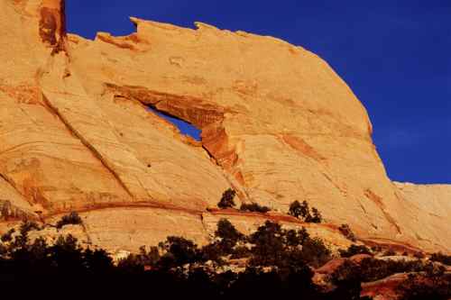
Upper Muley Twist Canyon, Utah

Landscape photographer Phil Armitage posts a Day Hikes in Capitol Reef National Park page.

… The trail through Upper Muley Twist Canyon is often cited as the best hike in Capitol Reef National Park, and I’d agree with that consensus. It’s a moderately difficult full-day hike that has a little bit of everything – an interesting canyon, natural arches, and a ridge-top walk with a spectacular panoramic view. …

Total distance for the (partial) loop is about 9 miles if you start at the Strike Valley Overlook parking area, or about 15 miles if – like me – you start at the 2WD parking area further down the road. …

The jumping off point for Capitol Reef is Torrey, Utah.

Torrey is 213 miles from Salt Lake City, 350 miles from Las Vegas, and 220 miles from Grand Junction in Colorado. …

Day Hikes in Capitol Reef National Park

I hiked Lower Muley. Now I’ve got to return to do the Upper section.

Thanks Phil.

Check his home page: PhilArmitage.net

youngest ever to climb Everest

It’s easy to criticize the parents for letting their “child” do something so dangerous.

A 13-Year-Old Kid Has Summited Everest

But this kid is no rookie. He’s already completed 6 of the 7 summits. In December he’s scheduled to attempt Vinson Massif in Antarctica.

There’s some age that’s “too young” for high altitude mountaineering. But I’m not sure what age that would be. It depends on the child, I’m thinking.

Lower Muley Twist Canyon, Utah

trip report by site editor Rick McCharles

My best hike so far on this Southwest U.S.A. road trip was a little visited slot canyon in Capitol Reef National Park.

It’s now high on our list of the best hikes in North America.

Over a 24hr period I saw no hikers, nor did I see any motor vehicles while tenting at nearby Cedar Mesa campground. The trailhead register showed one or two hiking groups a day, on average.

… a deep, narrow, twisting canyon with large alcoves. The canyon offers many opportunities for side trips and exploring.

From 1881 to 1884, the canyon served as a wagon route for Mormon pioneers traveling south toward San Juan County. The canyon was thought to be narrow enough to “twist a mule” hence the name Muley Twist. The Post cutoff trail is marked with rock cairns and signs, but carrying a topographic map is recommended. It is extremely hot in summer and water sources are unreliable; carry adequate water. Use caution in narrow canyons particularly during flash flood season (typically July-September). …

Best season for hike: Spring and Fall

NPS

The first decision to make is trailhead. I chose the Post parking area. That makes for a perfect “loop” hike of about 15mi.

hiking Lower Muley Twist Canyon

The trail into the wilderness is well marked.

hiking Lower Muley Twist Canyon

Looking back one last time at my vehicle. Would I be lost in the canyons, never to return?

hiking Lower Muley Twist Canyon

Actually, I did not get lost. (much)

Stone cairns led me to the signed intersection with the main canyon trail. If confused, you could always ask one of the locals.

hiking Lower Muley Twist Canyon

Wildflowers are a good reason to hike the desert in the Spring. They were fantastic when I was there.

hiking Lower Muley Twist Canyon

hiking Lower Muley Twist Canyon

But the main attraction of Muley are the massive rock alcoves, as impressive as any I’ve seen anywhere.

hiking Lower Muley Twist Canyon

hiking Lower Muley Twist Canyon

hiking Lower Muley Twist Canyon

You can’t help but wonder how this tiny stream could have carved them.

There is enough water to support some BIG trees.

hiking Lower Muley Twist Canyon

Here’s where the canyon finally narrows enough to “twist a mule”.

Exiting the “narrows”, you should immediately scramble left out of the canyon. I missed it, wandering further.

Checking my Lonely Planet Hiking USA guidebook, I had to backtrack to continue the loop back to my vehicle.

The final section out in the open is much different, but still interesting …

hiking Lower Muley Twist Canyon

… and colourful.

hiking Lower Muley Twist Canyon

Next time … Upper Muley Twist Canyon. Or, perhaps a thru hike connecting the two.

See all my photos of Lower Muley Twist Canyon on Flickr.

All in all, I’d call this a perfect hike. Highly recommended, especially if you don’t like crowds.

The Notom to Bullfrog access road is scenic and (normally) quite safe, even for low clearance vehicles. Don’t let access dissuade you from going.

near Valley of Fire, Nevada

trip report by editor Rick McCharles

I set up camp here …

near Valley of Fire, Nevada

Hopped on my mountain bike, heading for the hills.

Civilization? A long abandoned dam:

near Valley of Fire, Nevada

I jumped off my bike upon reaching this rock formation, perfect for scrambling.

Summit Stone is atop the highest point of this formation.

Atop the highest point, this guy, seemingly a madman, placed a Summit Stone. Will anyone ever find it?

Rick with Summit Stone

What a terrific outdoor adventure. No hiking guidebook needed.

Rick - near Valley of Fire, Nevada

best hiking desert park – Death Valley

I’ve been many weeks hiking the deserts of the American southwest.

Wonderful.

The best of all, I’m thinking, is Death Valley.

… the lowest, driest, and hottest locations in North America. Badwater, a basin located within Death Valley, is the specific location of the lowest elevation in North America at 282 ft (85.5 m ) below sea level. …

Big, weird and wonderful.

The best hike is Telescope Peak.

Golden Canyon trailhead up to Zabriskie Point would be the signature day hike.

I’m reminiscing about the Valley of Death already.

Death Valley sand dunes

Amazon – Hiking California’s Desert Parks

Adventure Sports Week LOOMS

I’m looking forward to the second annual ASW. Will you be there?

2010 Dates June 4-13

Each June in Northern Idaho, Adventure Sports Week offers 10 days of racing, training, clinics, gear demos and more. ASW features triathlons, mountain biking, trail running, adventure racing, open water kayaking and swimming.

Our venue is located on the shores of Lake Pend Oreille at Farragut State Park.

home page

• Schedule of Races

• Registration

• Venue

hiking Navajo Knobs, Utah

trip report by site editor Rick McCharles

Though May is reckoned to be the best month to hike Capitol Reef, rather than set up a tent I fled to this little “camping cabin“.

hiking Navajo Knobs, Utah

Good call. Morning dawned well below zero with plenty of snow on the ground.

hiking Navajo Knobs, Utah

The Visitor Center is everyone’s first stop. From there it’s only a few miles to Hickman Bridge trailhead where you have the option of 4 hikes:

• Hickman Bridge
• Rim Overlook
• Navajo Knobs – 9mi return, 1649ft ascent
• Cohab Canyon

These range from “easy” (Hickman Bridge) to “challenging” (The Knobs), ideal for a mixed ability group.

The route is well marked with cairns.

hiking Navajo Knobs, Utah

Views are wonderful throughout though there’s not much protection from wind and sun.

Pectols Pyramid is the first highlight of many.

Pectols Pyramid - hiking Navajo Knobs, Utah

hiking Navajo Knobs, Utah

My first rattlesnake ever! (They’ve seen me, but I’ve never seen one of them.)

hiking Navajo Knobs, Utah

… Apparently it’s too early in the Spring for this guy. And a Ranger told me they are only very rarely found on this trail.

Was he looking for this guy?

hiking Navajo Knobs, Utah

The route climbs parallel with the highway. Here’s the valley far below:

hiking Navajo Knobs, Utah

That’s them?

The Navajo Knobs?

hiking Navajo Knobs, Utah

A bit of a let down. They’re simply 2 bumps of limestone atop the Waterpocket Fold. The main reason to go the extra miles is to see around the corner. It’s impressive!

I left a Summit Stone atop one Knob, reward for anyone keen enough to get up there.

Rangers were pushing this guidebook: Capitol Reef National Park – The Complete Hiking and Touring Guide.

I used my trusty Lonely Planet Hiking in the USA.

As both a driving tour, and hiking destination, I highly recommend Capitol Reef.

See the rest of my photos from this day hike.

USA hikes with Gorgeous Finales

A good list from divine caroline by Vicki Santillano:

Kalalau Trail, Hawaii
Half Dome, California
Conundrum Creek Trail, Colorado
Bright Angel Trail, Arizona
The Hollywood Trail, California
Mount Riga State Park Trail, Connecticut
OldRag Mountain Hike, Virginia
Raven Cliff Falls Trail, Georgia
Mount Whitney Trail, California

… The ends of these popular hikes can replenish the most tired and weary of walkers and instill an invigorating sense of accomplishment in them. … the more motivation you’ll have to keep walking when the trails get tough …

click through for details and photos of each – Nine U.S. Hikes with Gorgeous Finales

(via Chris Weiss on uncooped who adds Angel’s Landing, Utah)

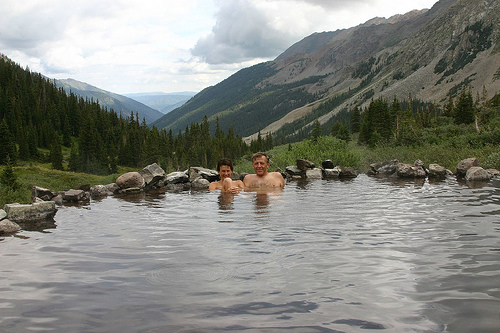
I’m liking Conundrum Hot Springs.

… located at a staggering 11,200′ within the famous Maroon Bells in the Snowmass wilderness. These steamy pools are 8.5 miles up the Conundrum Creek trail just outside of Aspen. …

click photo for details

Anniversary Narrows, Lake Mead, Nevada

trip report by site editor Rick McCharles

As beautiful a slot canyon as any other on earth.

How could I resist?

That claim made by one of my guidebooks, Afoot and Afield Las Vegas, the best of those I used.

Simple.

Drive to this trailhead. …

Anniversary Narrows, Lake Mead, Nevada

An easy 2.5mi out-and-back.

Unfortunately, I didn’t do that.

Instead I parked on the highway, not trusting my low clearance vehicle to make it to the trailhead. This added about 2.5mi to the trip.

En route a couple of hikers told me I was off-route. They could not find the trailhead. (It was there.)

I diverted to the only other possible watercourse, following footprints down a dry creek. It looked feasible.

WRONG.

I circumambulated a minor peak on a scramble soon dubbed the DANGER MINE trail.

Anniversary Narrows, Lake Mead, Nevada

There must have been a dozen old mine shafts up there, right to the top of the peak.

Finally I spied hikers far below. On my original, correct route.

Anniversary Narrows, Lake Mead, Nevada

Anniversary Narrows are lovely.

Anniversary Narrows, Lake Mead, Nevada

Rick straddling Anniversary Narrows, Lake Mead, Nevada

Recommended. But another cautionary tale of how easy it is to get lost in the desert. It’s possible to fall into an abandoned mine shaft out there, too.

The crumbling ruins of the mining operation are a historical attraction.

Anniversary Narrows, Lake Mead, Nevada

see all my photos from this trip