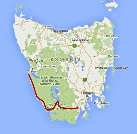
Between February 27 and March 22 of this year, I completed a traverse of the southwestern region of the state. One of the wildest, most pristine backcountry areas on the planet, it was a hike I had dreamed of doing for almost two decades. …
200 miles (322 km) approx. …
Time: 24 days
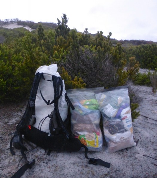
Daily Average: 8 miles (13 km) approx. This included one rest/resupply day. Hiking, scrambling, bushwhacking, climbing, paddling, crawling, swimming, rock hopping…………yep……..the terrain really was that challenging …
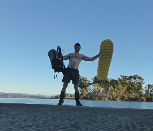
Celebrating after paddling the 150 metres crossing between Piners and Settlement Points on my Thermarest NeoAir. My backpack floated behind, attached with some guyline to my right leg.
5.6 miles, roundtrip
Elevation Gain: 1300 ft.
Highest Point: 1500 ft.
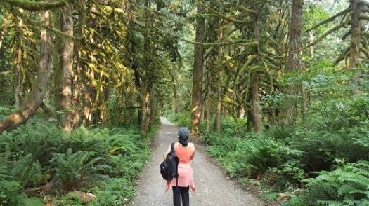
I camped at Flowing Lake Park. Tried to get an early start. But the trail was busy, busy, busy even on a Friday in April.
Washington Trails Association has the best write-up:
Despite the foot traffic Wallace Falls sees as one of Washington’s most popular attractions, those who get out early on the trailhead will be rewarded with a serene tranquility that few other hikes in the area can offer. And unlike many trails, which sacrifice peripheral scenery on the journey for the prospect of a grand summit view, the Woody Trail is consistently gorgeous as you wind your way along the Wallace River and approach the nine dazzling falls. …
The Dogon Escarpment is an amazing geographical feature in Mali.
… it’s pretty much obligatory to do it with a guide on a ‘trek’. …
Most of the hiking in Dogon Country is on flat, sandy ground. There is a climb up the 500 metre escarpment (probably) but apart from that the terrain is unlikely to challenge any one. One walks from small town to small town, where you can see traditional life going on without a HUGE change from the outside world. The towns don’t have electricity for example, and you won’t see many vehicles. …
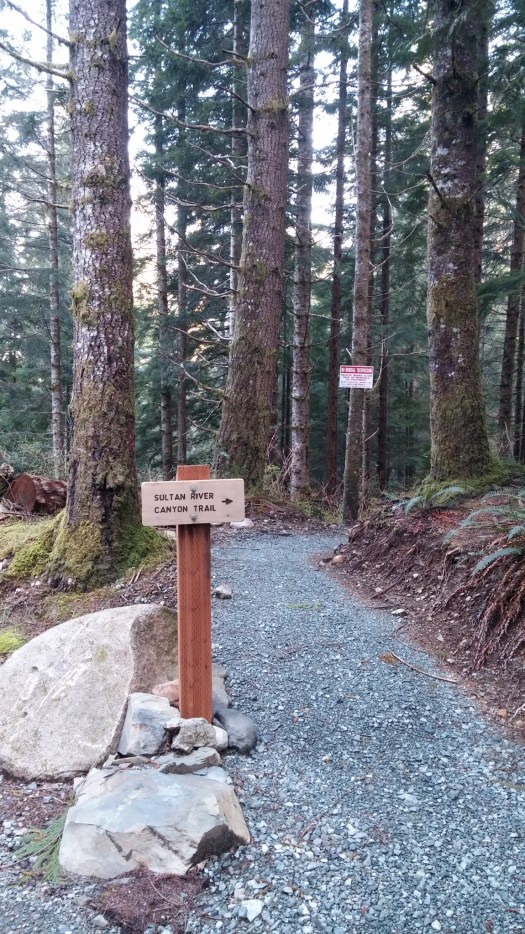
Opened in 2015, this new tail takes you deep into the Sultan River Canyon where towering old growth trees and steep slopes shade a remote section of the Sultan River. …
That was enough for me. I was first on the trail April 9th, early in the hiking season. I ran some of the flats and downhill … and walked uphill.
You can drive out as far as Culmback Dam.
Spada Lake is the reservoir for Everett, WA.
From there it’s about 1mi walk on a good logging road before you drop steeply into the canyon.
The trail dead ends at the river. I relaxed on a rock in the river for a good 10 minutes.
Then began the climb back up while listening to an audio book for motivation. 🙂
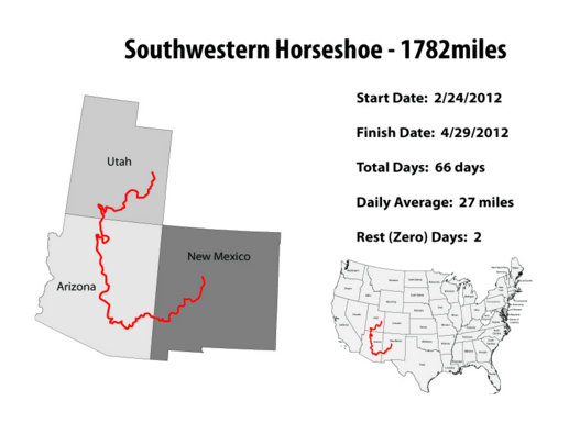
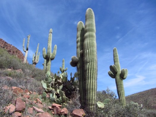
The Southwestern Horseshoe (SWH) is an approximately 1800 mile (2896 km) backcountry route from Arches National Park to Albuquerque.
… of all the thru-hikes I have done in the US, the Southwestern Horseshoe (SWH) was perhaps the one I was looking forward to the most. The Colorado Plateau in particular, with its hoodoos, rock monoliths, natural bridgesandslot canyons, had long been on my backcountry radar, ever since reading the works of Colin Fletcher and Edward Abbey as a young man growing up in Australia. …
While the Kungsleden trail is one of the most popular hiking routes in Sweden, as August passes to September and the end of the short arctic summer nears, the crowds begin to thin and the trail grows quiet as the land awaits the coming of winter.
The arrival of September sees the birch forests turn a golden yellow and the blueberries glow bright red, while the wide valleys rise to snow-capped mountains. The days become cold and the air crisp as snow flurries blow over you. The nights become dark again and northern lights once again dance in the sky.
Female hiker with snow covered mountains and autumn colors in southern end of Tjäktjavagge on Kungsleden trail, Lappland, Sweden
Autumn is a wild, colorful, lonely, exhilarating, adventurous, time to experience the wilds of Sweden’s north. …
The mountain huts are seasonal, typically closing in mid September. September 21 for 2014.
Candlelight illumintes room Singi mountain hut at night, Kungsleden trail, Lappland, Sweden
The longest distance between any two huts is 21 km, Alesjaure – Abiskojaure. The average distance for the rest is about 12-14 km.
The price for a bed while the huts are open is between 295 – 330 SEK (in September).
… This video is the culmination of a month spent backpacking through Olympic National Park. We chose Olympic as our first of the More Than Just Parks short films due to its incredible diversity. It is unlike any park on the planet offering glacial mountain peaks, old-growth rainforests, and over seventy miles of wilderness coast – all within a day’s drive. This film was shot entirely in 4K.


 #1)
#1) 
