Victoria Falls, Zambia

While it is neither the highest nor the widest waterfall in the world, it is classified as the largest, based on its width of 1,708 metres (5,604 ft) and height of 108 metres (354 ft), resulting in the world’s largest sheet of falling water.

… In height and width Victoria Falls is rivalled only by Argentina and Brazil’s Iguazu Falls. …

The spray from the falls typically rises to a height of over 400 metres (1,300 ft), and sometimes even twice as high, and is visible from up to 48 km (30 mi) away. …

Though a jerk and inept leader, David Livingstone was one of the first Westerners to make a transcontinental journey across Africa. And might have been the first non-African to see Victoria Falls.

statue near the Falls

Although Livingstone is known as “Africa’s greatest missionary,” he is only recorded as having converted one African. That might be to his credit, actually. 🙂

New York Herald reporter Henry Stanley could not convince Livingstone to leave. The great explorer died of malaria and dysentery.

IMG_1856

The baboons look bored. But I was thrilled to finally reach Victoria Falls, one of the great tourist destinations of the world.

From the Zambia side, you get an unbelievable distant photo vantage.

IMG_1826

First Gorge, from Zambian side

IMG_1824

Walking the Knife-Edge Bridge during high water is something like walking through the waterfall. It’s not always easy to see the Falls.

IMG_1847

Drenched anyway, I made the wet descent to the river on the Boiling Pot trail.

IMG_1863

IMG_1862

That day I didn’t see anyone bungie jumping from the Victoria Falls bridge. But I hear it’s awesome. (VIDEO)

My photos don’t do this natural wonder of the world justice. Nobody leaves disappointed. Victoria Falls are magical.

Click PLAY or watch a video on YouTube.

I’d love to return, just to visit from the Zimbabwe side.

IMG_1816

Gxalingenwa hike, South Africa

trip report by site editor Rick McCharles

One of the best day hikes in South Africa.

At Sani Lodge Backpackers in the Drakensberg you get everything you need.

trail description, permit, map

Step out the back door, you’re on your way.

IMG_0209

IMG_0212

After about 250m you reach the perimeter fence of the KZN protected lands. Permit to hike costs about $3.

IMG_0214

Every step is beautiful in the Drakensberg. Wide open.

IMG_0217

Some African dung beetles are endangered. NOT the ones in these mountains. There are plenty.

IMG_0224

Lizards are constant companions.

IMG_0229

You see a lot of scat, many interesting prints, yet not much wildlife. Animals here have evolved to be elusive.

IMG_0235

I was thrilled to see my first grey rhebok.

IMG_0232

Alpha males “cough” at you from a safe distance.

Wild flowers were still in profusion, mid-summer. We’d had a lot of rain.

IMG_0245

I left a Summit Stone for some future hiker to discover.

IMG_0220

Here’s Gxalingenwa cave. These two spent two nights here, sheltered from the rain.

IMG_0249

Later I learned you are not officially allowed to camp there.

From the cave I had to either backtrack … or finish a loop down the river.

IMG_0252

I’d been warned that the water was high. That I’d most likely need to wade the creek several times.

IMG_0255

Boulder hopping my second crossing, I fell in. 😦

And — since the shoes were wet — I waded 3 more crossings.

IMG_0253

IMG_0256

Russell at Sani Backpackers wants to improve the trail staying on one side of the creek. One day.

IMG_0260

I was glad to have done Gxalingenwa as a loop. It’s very pretty coming down.

IMG_0258

IMG_0259

Some hike up to these waterfalls from the roadway.

The only downside of the Gxalingenwa loop from Sani Backpackers is a road walk finish.

IMG_0265

Happily, I was picked up. Given a lift by University researchers who happened to be staying at the Backpackers.

more photos from this day hike

Lake of Eternal Life, Iceland

HANK LEUKART:

Brian and I start by trekking two classic, connected Iceland treks: the Fimmvörðuháls and Laugavegur Trails, the first of which begins at a huge waterfall called Skógafoss on the southern coast.

We feel almost disappointed to be enveloped by the sublime, rolling, green hills and plethora of waterfalls, because it feels like we’re in the most beautiful place in Iceland already — we’re getting a fantastic payoff way too early in our trip. Soon enough, though, as we continue through the snow and glaciers near Fimmvörðuháls Hut, it becomes obvious that there’s no chance Iceland will ever disappoint us no matter where we go. …

Click PLAY or watch it on Vimeo.

In January 2014, the Icelandic government announced plans to revoke 30-year-old environmental protections, putting Mývatn Lake, the Þjórsá River, and the Highlands in danger of destruction so that new hydropower plants can be built. Three waterfalls on the Þjórsá River — Kjálkaversfoss, Dynkur, and Gljúfurleitarfoss — may be ruined. Now may be the last time in history that hikers can see all of Iceland’s natural, untouched beauty …

read more – Without Baggage – Mission Iceland: A Tale of Two Brothers

Two brothers search for eternal life in the Icelandic wilderness.

Thukela Gorge, South Africa

I hiked to the top of Thukela Falls, one of the highest in the world. There’s another terrific trek in the National Park to the base of the Falls.

Trip report from the Cooking in Tongues blog:

Royal Natal National Park, Drakensberg Mountains, South Africa, September 26, 2011

I’m up early hoping to catch the first rays of light on the Amphitheater. The cliff face glows in the early morning light just before 6. …

… about nine miles round trip up the gorge with great views of the Amphitheater. …

Royal Natal Rest Camp - early morning

We follow the river upstream until we come to the confluence of two rivers. Here you have the option of taking the “tunnel” along the river through the gorge or climbing the chain ladder up about 50 feet to a path that bypasses the “tunnel”. …

Royal Natal - Gorge walk - inside tunnel

read more …

Amphitheater trek, South Africa

Trip report by site editor Rick McCharles.

Within 36hrs of landing in JoBurg I found myself atop the Amphitheater cliffs looking down at one of the highest waterfalls in the world.

IMG_0090

How did I get here?

It’s easy.

Catch the Baz Bus to Amphitheater backpackers in the northern Drakensberg.

While checking into the hostel, sign up for their most popular guided hike. It’s offered about every 2nd day for about $50 all inclusive.

7:30am departure.

IMG_0004

Here’s our guide “Sim” parking one of the hiker shuttle vans at Sentinel car park 2,500m (8,200 ft). This is the only official day hiking trail leading to the top of the Drakensberg escarpment.

IMG_0010

IMG_0008

Yep. That’s the Sentinel. You cannot climb it without ropes. We’ll skirt the base.

The trail zigzags up towards the big peak. Then traverses right.

IMG_0009

IMG_0034

Entirely above the treeline, we did not see much in the way of wildlife. Aside from lizards, of course.

IMG_0012

It was an easy start with perfect weather.

One short ladder on the ascent.

IMG_0029

The crux of the hike is up this gorge.

IMG_0047

It’s a 300m scramble. Not too difficult overall.

Atop the Amphitheater cliffs, we stopped for lunch. Our guides were disappointed that clouds obscured the fantastic views.

IMG_0056

Note the big birds that stopped for lunch with us.

IMG_0057

20min further is the top of Tugela Falls.

IMG_0080

IMG_0085

The water is quite warm. … I’m told.

IMG_0086

Our guide told us that one hiker fell from here on a winter trek. Slipped on the ice.

Finally I called on the old Gods and new to dissipate the clouds.

Everything opened up. And we were shocked to see where we’d been standing so casually.

IMG_0110

It’s about 1km down.

The Amphitheatre is widely regarded as one of the most impressive cliff faces on earth, over 5km (3.1mi) in length.

IMG_0114

Surprisingly, these cliffs are not much used for BASE jumping and the ilk. Apparently winds are not favourable here.

One girl from Finland had been to Roraima via Venezuela. She said there were definitely similarities with the top of the Tupuis there …

IMG_0115

… But many differences too.

The standard route is a Lollypop loop. Rather than backtracking we descended via long ladders.

IMG_0133

IMG_0128

From the bottom, it was another cliff traverse to regain our original trail.

IMG_0137

The vegetation in South Africa is different than what I’m used to. The most interesting plant is this … Pineapple something.

IMG_0143

IMG_0144

One intensely scenic day. We all left happy.

This New Yorker was on the last 4 days of 2 years of traveling.

IMG_0130

Back at the car park we enjoyed a gymnastics performance.

headstand South Africa

And saw one sleepy snake close to where we parked the vans.

more pics from this trek

I didn’t delete many photos as most up there in the Bergs were cool. 🙂

related – Controversy Between Tugela Falls and Angel Falls as World’s Tallest Waterfall

arrived Drakensberg

Just checked in at Amphitheatre Backpackers in the northern Drakensberg. Superb location. Weather is great for January.

P1270016

P1270018

South Africa is incredibly easy to travel staying in hostels like these. Getting around by Baz Bus.

I’m already booked for the essential Amphitheatre trek tomorrow, guided. That takes us to the top of Tugela Falls (Thukela Falls), a total drop of 947 metres.

The day after we’ll take a cultural hike in Lesotho. Or climb Cathedral peak — if enough people sign up. 🙂

Thukela Gorge Walk trip report (Sept)

related – India hates tourists

Manaslu Circuit – day 4

by site editor Rick McCharles

I awoke early. Went out to get some photos at first light.

P1240782

I went also to find a good and quiet boulder for a movement. I’d been constipated on this trek so far, my bowels clenched at the smell of every Nepali outhouse.

P1240784

Jagat means “checkpoint” (or something like that) in Nepali. Everyone must have the correct permits. Nobody can sneak past unseen.

Actually, Brion and Betsy were missing one of their 3 required permits. Their trekking company had bungled.

Happily, they were able to pay an additional fee and buy it here.

In Nepal you should be careful to treat all water. I used tablets. New to me was the steriPEN.

P1240791

Amazing.

Much improved from my last trip to the Himalaya are LED light bulbs.

P1240789I once carried a 100 watt bulb and replaced the one in my guesthouse cell for the night. No more need for that. The LEDs are quite bright.

We got a fairly early start, the valley still in shade. Days are short in November. Sunlight precious.

P1240795

We stopped along the river to watch a brick maker.

P1240794

Already loving this trek, it got even better as the BIG mountains came into view.

P1240813

On the other hand, between 10am and 2pm is rush hour.

P1240820

If you happen to get behind one of the big French expeditions, it can be slow going.

There are far more French hikers on Manaslu than any other nationality. They mostly tent.

For some reason they mostly eat at guesthouse restaurants rather than at their campsites. That helps the local economies.

P1240841

Electricity is more available than on Everest or Annapurna. There’s plenty of solar. And a number of micro Hydro stations en route.

P1240852

Tourism is to credit for that, I believe.

Not all the local people are happy with the increased number of funny looking foreigners walking past.

P1240857

The young will have grown up with tourists.

P1240826

No motor vehicle road will ever be blasted here.

P1240872

My guide figures it will take 15-20yrs.

P1240877

I love this kind of trekking.

P1240917

We slept in Dyang 1800m. More snow was falling up high.

more snow

It’s starting to get cold at night.

P1240927

see high resolution photos from this day on flickr

day 0 | day 1 | day 2 | day 3 | day 4 | day 5 | day 6 | day 7 | day 8 | day 9 | day 10 | info

Manaslu Circuit – day 3

by site editor Rick McCharles

Already tired of tiny, potentially unsanitary tea house bedrooms, I’d slept in my tent the previous night.

Yep. As I’ve done on my previous Himalayan tea house treks, I carried a tent. Only 2lbs (Hubba) … I like having the back-up plan.

I slept in my tent until 1:20am when guides woke me in a panic. At the next guesthouse campsite, a thief had cut through a tent and stolen a backpack. It contained a Passport, camera and plenty of cash. Everyone insisted that I must move indoors. For my own safety. 😦

P1240596
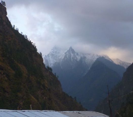
Ascending next morning, the valley looked to be narrowing further.

P1240590P1240603P1240600

There are people everywhere in this valley. Here Brion was looking for a public toilet. The “blue door”, he was told.

P1240607

That one wasn’t bad. But as a general rule I’d recommend you avoid Nepali toilets. It’s more sanitary to sit in the woods. … Assuming you can find a good spot.

This was cute. Kids blocking off their home from pack animals.

P1240586

Here’s some fencing trying to keep out hungry beasts.

P1240612

Harvested crops are usually stored up high out of reach.

P1240726

Tradition here is to use ladders to get up and down.

P1240772

I had the standard Himalayan meal for lunch.

Dal bhat consists of steamed rice and a cooked lentil soup called dal. Potatoes on the side they call “curry”. The spiciest component they call “pickle” (achar). Often greens are included as they were this time.

P1240675

Porters and guides can rarely be persuaded to eat anything else. It’s dal baht 3 meals a day. They always eat separately and after their clients. In fact, one of the highest priority jobs for any guide is to act as your waiter. They do everything they can to keep you happy and healthy on the Trail.

Pretty pretty.

P1240626

P1240632

Steep gorges like this are prone to washout.

P1240696

Winter loomed. Every home had enough wood stockpiled.

P1240742

P1240673

Compared with Everest and Annapurna, there are far more waterfalls on Manaslu.

P1240649

Impressive too are the many beautiful butterflies.

P1240701

Everyone is anticipating this adventure to boom over the next few years. We saw many, many guest houses under construction.

P1240713

We were surprised to get some rain. It should be bone dry in November. … We didn’t realize at the time that this same day it was snowing up on the high Pass.

P1240721

Jagat

We slept in Jagat 1410m, a pretty village.

see high resolution photos from this day on flickr

day 0 | day 1 | day 2 | day 3 | day 4 | day 5 | day 6 | day 7 | day 8 | day 9 | day 10 | info

our West Coast Trail 2013

I’m just back from our #1 hike in the world. 🙂

Detailed trip report coming in September — following our reunion slide show & meet up in Saskatoon.

Until then, here’s a short video montage that will give you a glimpse.

Click PLAY or watch it on YouTube.