scrambling Mt Angeles, Olympics WA

trip report by site editor Rick McCharles

Mount Angeles is the highest point between Hurricane Ridge and the Strait of Juan De Fuca in Olympic National Park.

It offers incredible views from Canada to Mount Olympus.

It is only about 15 miles from the town of Port Angeles and is a very popular climb, both in winter and summer.

Summer offers a hike and a scramble to the top while winter offers a nice fairly easy snowclimb with a short easy chute at the end to the summit. Because this is so close to the ocean, the mountains tend to dump a lot of moisture with nasty weather. It is after all how Hurricane Ridge got its name. …

The main trail is the Mount Angeles Climbers’ Trail which switchbacks up the south side before switching over to the west side and then up a chute to the summit. There is an option on the East Ridge that offers some scrambling up the ridge to the summit. …

read more on Summit Post

Mt Angeles

I’d decided on a whim — after chatting with a descending runner on the Sunrise Ridge Trail — to try to climb the peak. Not knowing any better, I blasted straight up the face.

 6454 ft
6454 ft

I took the “easy” way down. Slowly and carefully. Descending is far more dangerous than climbing.

No water. Some report mosquitoes though I had none the day I climbed.

Given its close proximity to the Hurricane Ridge Visitor Center, the climbers’ trail route is frequently climbed by determined hikers, and even a few tourists manage to reach the summit, although the mountain is far too craggy and exposed to recommend it to any but experienced scramblers.

Accidents due to slips and falls on loose rock and snow account for many accidents on Mount Angeles.

Climbing Washington

scrambling Moose Peak, WA

trip report by site editor Rick McCharles

My FUN adventure in Olympic National Park Washington State.

Obstruction Point
Obstruction Point

You MUST have good weather. Otherwise, stay low. Obstruction Point is already high at 6100ft. The summit of Moose is 6753ft (2058m).

It’s mostly gorgeous alpine meadow ridge walk in the direction of Moose Lake. There was some snow left on the trail on July 4th, but nothing to worry about.

ridge

Hikers enjoy the wild flowers this early in the season.

wildflowers

Head on the trail towards Grand Lake, Moose Lake, Grand Pass. It’s about 2mi to the “Grand Valley” trail cut-off, elevation 6450ft.

You’ll know you’re there when you see this TRAIL sign.

trail

Some trip reports found the ridge scramble fairly easy.

ridge scramble

I actually found it challenging. Depends on the route, I guess. I stayed as high on the ridge as possible on the way out. … Took the lower (obvious) easy trail across the scree on the return.

Fantastic views on top, of course. Those are Grand and Moose Lakes below.

lakes

I left a Summit Stone.

Summit Stone

LOVE Moose Summit. 🙂

Rick on Moose

Moose is not named after Moose, surprisingly. It’s named after some guy with the last name of MOOSE.

There is no water high in the Olympics. Bring your own. Or melt snow.

related:

• Explore Olympics – Gary Huff – Moose Mountain

• Summit Post – Moose Peak

scrambling Breakneck Ridge, NY

Disappointed with the other day hikes I’d checked close to NY City, I made a special trip to the best of the best.

Breakneck Ridge is a mountain along the Hudson River … Its distinctive rocky cliffs are visible for a long distance …

Breakneck from Hudson

… Lying within Hudson Highlands State Park, it offers many stunning views of the river and region and is quite popular with hikers, to the point that a rail flag stop has been established on the Metro North line which runs right by the base of the ridge along NY 9D.

While several routes exist, most hikers take the white-blazed route up the mountain’s west face that begins on the West (Southbound) side of Route 9D near the tunnel.

trailhead

After circling around to cross above the tunnels, it begins a steep, rocky and challenging climb up to the first bump of the mountain, about 720 feet (219 m) above the river, where there are sweeping views of the river and Highlands. …

Here’s that first “bump”, this flagpole.

Breakneck flag

As a former gymnast, I loved it. Using my hands as much as possible.

Scramble

The only time my heart rate jumped above 180 beats / minute was when I nearly stepped on this BIG BLACK (possibly deadly, I assumed) Western rat snake.

snake

(Or is it a northern black racer?)

I left a Summit Stone atop the highest point I could find.

Trip report by Big City girl Amy Cao:

With its close proximity to New York City (only an eighty-minute train ride from Grand Central), stunning vistas of the Hudson, Storm King Mountain, Mount Taurus and West Point Academy, it’s no wonder why Breakneck Ridge is an immensely popular hiking destination for those seeking to escape the frenetic city pace, if just for a day.

Repeatedly voted as one of the best trails in the country, Breakneck Ridge offers 5.5 miles of challenging rock climbs and rugged hikes for even the most seasoned Eagle Scout. You’ll need all four limbs to scramble up the first mile when suddenly the vertical ascent will have you scrunching your brow at how you managed to get stuck—and without safety equipment—between a rock and a hard place, with no way to go but up. The adrenaline is pumping at this point. …

I scrambled up and down. But you could opt for the Breakneck Ridge Loop.

MAP (PDF)

more photos of my day hike

yet more photos – Breakneck Ridge & Sugarloaf Mountain Hike

I rented a car. Tented at Beaver Pond Campground – Harriman State Park. Quiet mid-week, party central on summer weekends.

Table Mountain, Cape Town

by site editor Rick McCharles

There are at least 30 ways up Table Mountain, one of the world’s new “seven wonders of nature“. My first visit, I took the most popular, via Platteklip Gorge.

Arriving at the Lower Cable Station, I was shocked at the long line-ups.

1

2

There was no way I was going to wait for the cable car with that mob.

Having arrived on the hop-on, hop-off City Tour bus, I needed to walk 1.5km on Tafelberg Road to one of the Platteklip trailheads.

3

On a fine day like this, the views back over Cape Town are amazing.

4

Here’s the crux, Platteklip Gorge.

5

No problem on a nice day.

6

Hikers and climbers die here every year, however. But not normally on the Platteklip Gorge route.

The flat top mountain is great for exploring. Most of the horde stay close to the Upper Cable Car station.

7

I looked for unique species. … Most every species was new to me.

8

The geology is special too.

cliff view

Finding a small commemorative crucifix, I left a Summit Stone in the same spot.

9

This is the top of one of the world’s longest commercial rappels. Read some reviews.

rapel

Instead I paid about 100 Rand ($12) to take the cable car down.

cable car

See more of my photos from this fantastic day hike.

Next time to Cape Town I’ll do one of the longer routes. Perhaps the new guided 5-day Hoerikwaggo Trail from Table Mountain to Cape Point.

Rick Table Mountain

new Half Dome permit system

Remember the good old days when no Yosemite permit was needed?

… Since the permit system for climbing the cables on Half Dome was established two years ago, there has been quite a bit of conflict and frustration around the “first come, first serve” system. After the initial balking at the “reservation fee” required for permits, the attention soon shifted to the larger problem: permit scalpers. …

… the park service will be implementing a new strategy for Half Dome permits this year. Rather than a first come, first serve situation, those hoping to climb the cables this summer will be able to submit their name (and up to 6 guests) into a lottery for $4.50 online (or $6.50 over the phone). This reservation fee is non-refundable.

… The other major change is that the permits will no longer be transferable. …

Daily Hiker

It’s worth it if you’ve never been. Click PLAY or watch an awesome time lapse video on Vimeo.

(via Yosemite Blog)

despite regs, people still die on Half Dome

When the new permit system (400/day) went in, we hoped that some of the least capable, least prepared “tourists” would be dissuaded from tackling the cables.

But it’s been a bad year at Yosemite:

20 people have died on Half Dome over the decades, nearly all with rain as a factor, officials say. One of the two to perish this year was a Bay Area woman who slipped in a July storm and fell 800 feet. (A total of 13 died in park mishaps this year, the most in decades — including three swept over a raging waterfall on the trail to Half Dome.) …

Surprisingly, helicopter rescues are still free at that Park. But they don’t fly in bad weather — exactly the bad weather that traps people at the top.

Here’s an update on SFgate – Half Dome survivors wish they had taken heed

Note: You can try for a walk-up permit at 7 am the day before you want to climb.

related – Take a Long Hike – Before You Hike, Leave Critical Information

fleeing Mt Yari, Japan

trip report by site editor Rick McCharles

Day 2

I awoke before dawn in one of the best tent sites of my life.

This truly is the land of the rising sun.

Dozens of hikers were already atop nearby Mt Yari. It’s tradition to climb in the dark.

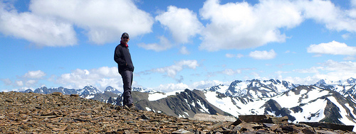
Personally, I was in no rush. The crowds were gone by the time I headed up.

In fact, I had the summit to myself. Nice.

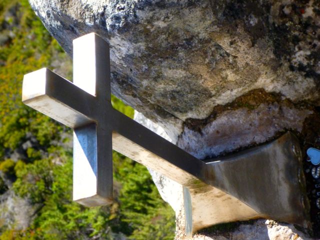
I left a Summit Stone at the Yari summit shrine.

A helicopter arrived. That’s Fuji in the distance.

helicopter and Fuji

An elderly gentleman was evacuated. He looked OK to me but had been on oxygen earlier in the morning.

I’m hoping he had insurance. Choppers are very expensive in Japan.

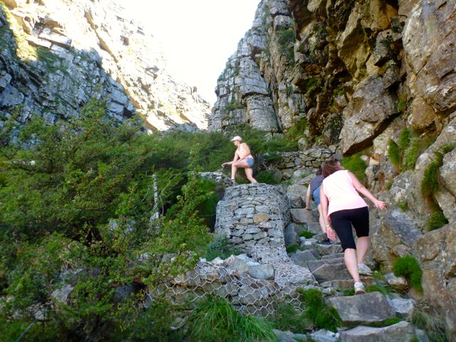
Here are the famous Yari ladders, trickier on the descent than the climb.

Though the weather could not have been finer, the forecast was for rain next day. I gambled, hoping it would hold off long enough for me to finish the Kamokochi – Yari – Hotaka circuit early next morning.

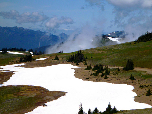
It was too tempting to spend the day walking the ridge towards Murado. Can you blame me?

This region is wrongly compared with Yosemite. In fact, it’s much like the GR20 in Corsica.

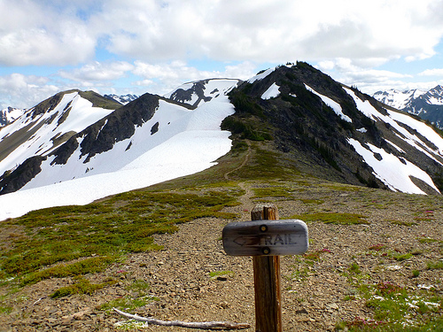
The nearest water to Yari I could find was at Sugoruko-goya.

They have quite an elaborate system ensuring a drinking supply for the hiking season. (But you may need to filter out the insects.)

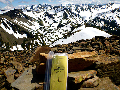
2pm was my turnaround time. It was even prettier on the way back.

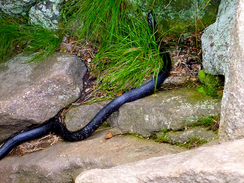
I did not see much wildlife. A pair of Rock Ptarmigan were the highlight.

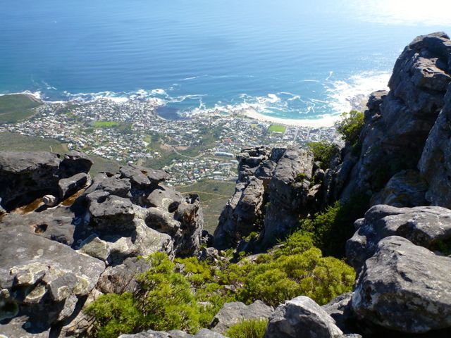
Can you believe this stunning view from Yari-dake-sanso at sunset?

Here’s my last photo of the day — my tent.

_____

In fact, that was my last photo of the trip.

Going to sleep at 8:30pm, I was awoken at 10:30pm. The storm had arrived.

Wind and driving rain all night kept me up. I listened to an audio book until first light.

It was all I could do to stuff my wet gear and flee back the way I came, the easy way down. This means I MISSED the infamous Diakiretto:

… hole in the ridge
… ladders, chains, big drops …

This is, without doubt, the most exhilarating (or the scariest) bit of hiking in Japan that doesn’t require any specialist skills.

Lonely Planet

That route is too dangerous when wet. I’d been warned by Wes Lang, editor of the Hiking in Japan blog.

See all my photos from day 2 of this adventure on Flickr

Or check Day 1 if you missed it.

fleeing the Japanese Alps

by site editor Rick McCharles

Just arrived back to civilization. …

I’m near certain the most popular overnight hiking destination in Japan is Kamikōchi.

People go to walk high ridges and scramble Mount Yari (槍ヶ岳 Yari-ga-take), … one of the 100 Famous Japanese Mountains. … 3,180 m (10,433 ft).

For two days we had perfect weather. (Trip report and photos coming soon.) I put up my tent on a ridge a couple of hundred metres beneath the “spear” (槍 yari).

The first night was fantastic, one of the best spots I’ve ever camped. Both sunset and sunrise.

… but the second night a raucous storm blew in at 10pm. Now I know why none of the Japanese selected such an exposed position.

I listened to an audio book all night, frantic to pack up my soaked belongings at first light, escaping directly to the Tokyo bus.

As a result I missed the infamous “Daikiretto” (die-key-ret-toe – all I see is ‘DIE’).

It will be too late in the season for me this Autumn, but one day I’d love to do the 65km Tate-Yama to Kamikochi traverse of the “Northern Alps”.

It’s somewhat similar to the GR20 in Corsica.

GR20 Trek Corsica – day 7

trip report by besthike editor Rick McCharles

» day 1 | day 2 | day 3 | cirque | day 4 | day 5 | day 6 | day 7 | advice |

Saturday, July 2nd, 2011

I was up early, following the rush of hikers up the mountain.

By now the 670m (2200ft) climb before breakfast was ho hum. It felt quite easy.

There’s no water (aside from snow) so everyone had bottles maxed out.

Simple. Follow the ridge. Scramble the peak on the left.

From here it’s only another 300m and some tricky scrambling to get to the summit of Monte d’Oro. On this perfect day, nobody opted for the lower (easier) route.

Soon I was caching a Summit Stone.

And enjoying the big view from 2389m.

All I talked to agreed the ascent was surprisingly easy that day. All dreaded the 1469m (4800ft) descent to the train station at Vizzavona.

I managed to find the steeper, shorter route. Knees and ankles feeling strong, it was not all that bad. My motivation was high knowing that I was going to finish today.

A couple of glisadding sections saved time. That’s the famed pyramid of d’Oro directly behind.

Arriving back in civilization, I joined fellow trekkers for an overpriced glass of wine in a restaurant. They had checked in to a hotel for one night, a splurge before continuing south on the GR20.

I, instead, tried to wash up at the (crappy) campsite.

And caught the next train to Ajaccio, birthplace of Napoleon.

By luck a ferry was leaving that night to return me to Nice, France. I enjoyed the nightlife (VIDEO), had a few too many Gelato cones and got on the boat. …

See more annotated photos from day 7.

Tomorrow I’ll post a wrap-up of the GR20 with advice for anyone who wants to test themselves on the “toughest hike in Western Europe”.

solo in the Cirque of Solitude

by Rick McCharles, editor of besthike.com

» day 1 | day 2 | day 3 | cirque | day 4 | day 5 | day 6 | day 7 | advice |

The Cirque de la Solitude is the crux of the GR20, one of the best and toughest hikes in the world.

Certainly it was the toughest trek of my life.

Tom Fordyce in The Guardian:

… The Cirque de la Solitude is the most notorious single section of the entire GR20. People are so scared of it that they huddle in petrified groups the night before, exchanging horror stories …

The Cirque turns out to be both gorgeous and terrifying at the same time. After 800m of rope-free climbing up, there’s 300m of straight down – straight down as in sheer rock-face, without even any pretense of a path. As a sop to the cowardly, there are some old chains bracketed into the smooth granite. … there’s nothing but the occasional spiky outcrop between you and the valley floor 1,200m below. …

Europe’s toughest trek: Corsica’s GR20

See more Cirque photos on Flickr.

Yet the feared Cirque of Solitude turned out to be the highlight of my GR20.

Tuesday, June 28th, 2011

I arrived late afternoon, the last 3 hikers (rock climbers) of the day having just finished crossing from the opposite direction. Each warned me of the seriousness of the traverse … in multiple languages.

Finally, alone, I dropped into the chasm.

descending into the Cirque

Chain assistance is essential when the rock is wet.

chains

In perfect conditions, I didn’t need them.

But I did need this on the ascent of the far side cliff, a steel ladder.

ladder

Moving slowly, carefully, I took about 2hrs to make the crossing, arriving at the far side just in time to ‘turn out the lights’.

author survives

Relieved to have achieved and survived, I was even more elated to have done it solitary.

Hikers joke about the name — Cirque of Solitude — as there is normally a log jam of folks bottle-necked at critical points. The main risk, in fact, is rock fall from someone above your fall line.

_____

This VIDEO gives a better idea of the challenge. Or this VIDEO (1min 30sec), in bad weather.

_____

Want to start planning your trek to Corsica?

Best Guidebooks in English:

• Trailblazer Corsica Trekking GR20 by David Abram (2008)
• Cicerone GR20: Corsica: The High-level route by Paddy Dillon (2010)