Sunshine Coast Trail – day 3

trip report by site editor Rick McCharles

Tin Hat Mountain to Elk Lake

day 1 | 2 | 3 | 4 | Sunshine Coast Trail information page

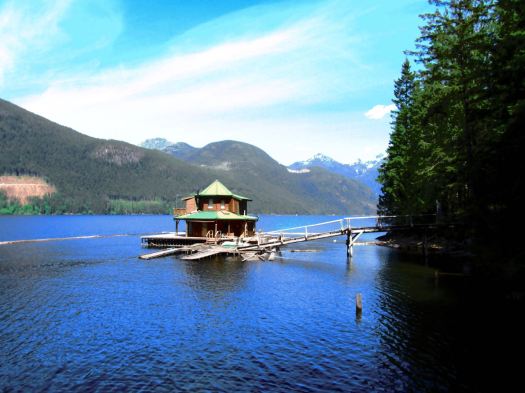
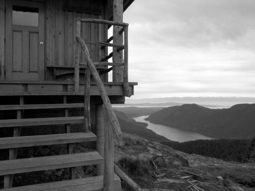
… the Tin Hat hut is an epic 360-degree mountain-top lookout that provides the quintessential view of the rugged mountains, valleys, and lakes that define the Powell River back country experience. This hut is a fully winterized cabin with pellet stove and is located in, arguably, one of the most beautiful spots on the Sunshine Coast Trail. Although it is a climb to get there, the experience is well worth the effort. Summitting this mountain will make you feel like you are, indeed, on top of the world!

tinhat_2

It’s the highest elevation point and the biggest attraction of the SCT. I was impressed.

IMG_0438

IMG_0437

Still early morning, I chatted with Lisa from Calgary in the hut. Then dashed on back down the logging road to where I’d stashed my pack. A savvy hiker like myself doesn’t haul his gear up the mountain unless absolutely necessary. My guidebook hinted at an alternative SCT route that would be easier than the normal steep up and down. 🙂

I was soon lost. 😦

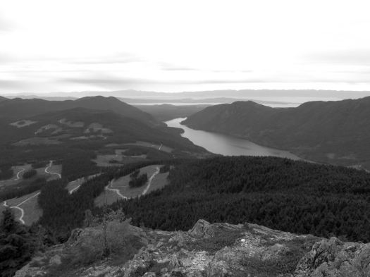
Views were terrific.

IMG_0436

But I found myself on a maze of logging road switchbacks. If you don’t like clear cut, you might not like the Sunshine Coast Trail.

IMG_0440

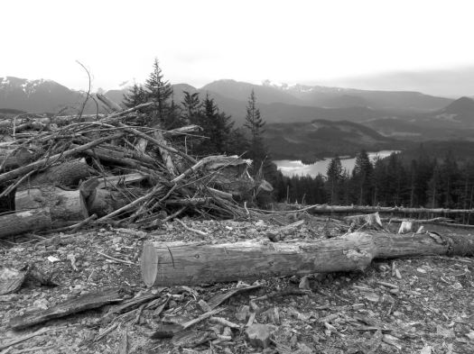
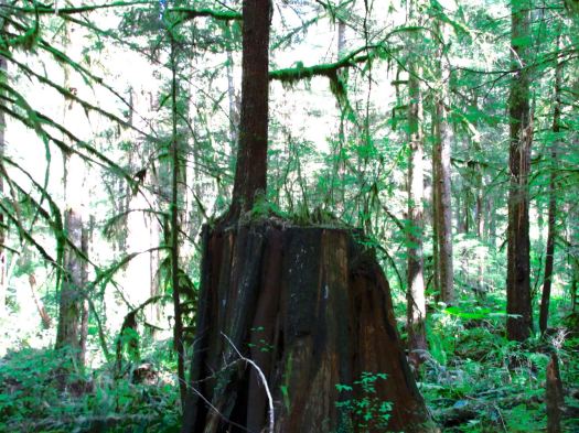
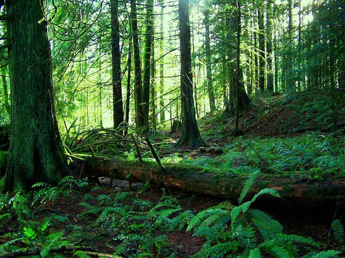
Here you can see an old growth survivor. Secondary growth. And the war zone that is clear cut logging.

IMG_0441

Worse than forest devastation, the bugs.

bug shirt
bug shirt

By day 3 I wore my bug shirt non-stop. Flying pests are a very good argument why you should NOT hike the Sunshine Coast Trail. All of the other major B.C. coastal hikes have virtually no bugs

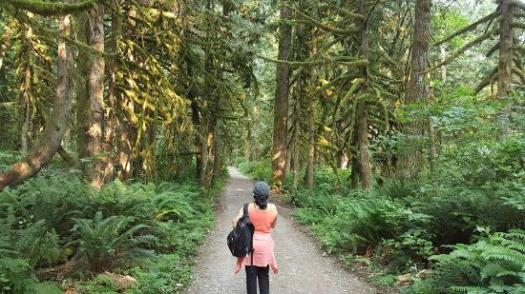
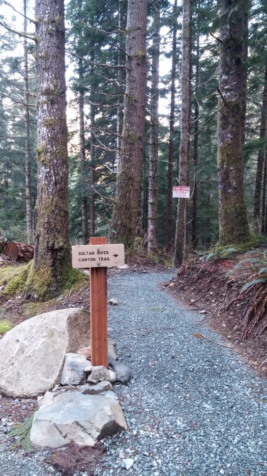
Eventually I found my way back to the SCT.
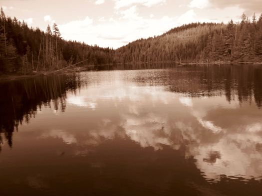
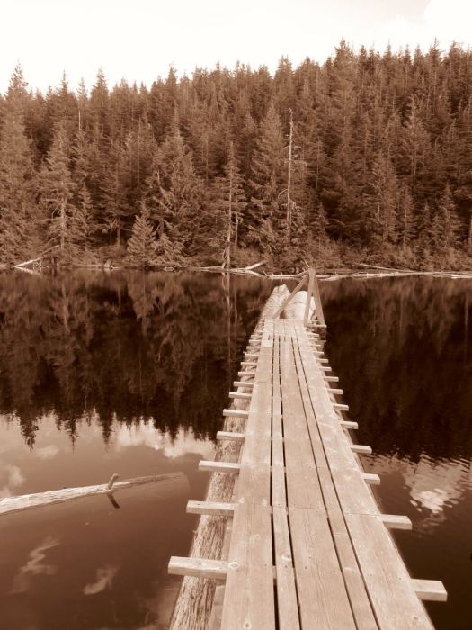
IMG_0445

Past Lewis Lake.

IMG_0446

On to Elk Lake.

Elk-Lake-summer

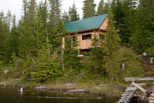
Mosquitos and I had the rustic hut to ourselves. Very tranquil.

IMG_0466

IMG_0467

IMG_0470

Close to dark Alex from Ontario rushed in. Super happy to have made it to the hut in daylight. She’d come from Tin Hat Hut.

day 1 | 2 | 3 | 4 | Sunshine Coast Trail information page

Sunshine Coast Trail – day 2

trip report by site editor Rick McCharles

Inland Lake to Tin Hat Mountain

day 1 | 2 | 3 | 4 | Sunshine Coast Trail information page

This was my toughest day. A steep scramble up to Confederation Hut on the same-named lake. Then a long descent down to Fiddlehead Landing Hut. And finally a steep slog up to the top of Tin Hat Mountain.

Tin Hat map

This is not Fiddlehead Landing Hut. Rather a floating holiday home next door.

IMG_0428

Hiking temperate rain forest can be lovely. Soft mulch underfoot. Plenty of variety. Nurse logs. Good visibility even in the trees.

IMG_0397

IMG_0430

I didn’t see much wildlife. Other than garter snakes.

IMG_0425

One snake was eating a banana slug. I’d believed NOTHING could eat a banana slug. 🙂

Lisa from Ontario had seen a bear near the start of SCT. But – in general – you don’t see much aside from birds.

… Fact is, I never made it to the top of the mountain. About an hour short of Tin Hat Hut I dropped my pack on the trail and set-up on the trail.

IMG_0434

Could barely keep my eyes open. That was 7pm. I’d been almost all of 12 hours on my feet. Mostly climbing up or down.

day 1 | 2 | 3 | 4 | Sunshine Coast Trail information page

Sunshine Coast Trail – day 1

trip report by site editor Rick McCharles

Mowat Bay to Inland Lake

My camera had multiple problems on this trip. Photos are inconsistent, at best. 😦

day 1 | 2 | 3 | 4 | Sunshine Coast Trail information page

AT A GLANCE

  • the best jumping off point for the SCT is Powell River, close to Vancouver B.C.
  • the Sunshine Coast is less rainy than the rest of the lower mainland, but can still be very wet
  • up to 180km (112mi)
  • possible to hike hut to hut without carrying a tent
  • huts “first-come, first-sleep”. Each can accommodate at least 12 hikers. More huts are being added.
  • Canada’s longest hut to hut hiking trail
  • NO permits or reservation required
  • free 🙂
  • it’s considered B.C.’s hidden gem of hiking routes. Many have not yet heard of this adventure.
  • recommended to carry a tent as a back-up. There are many scenarios which might cause you not to reach the next hut on any given day.

I caught the 10am ferry from Comox, Vancouver Island to Powell River.

sunshine-coast-map

My plan was to do the big central section. About 90km.

newmap

July 2015 we’d hired a boat to drop us at the northern trailhead Sarah Point. But quit the hike at Manzanita Hut after only 2 days. Driven out by mosquitos and wasps.

Could have taken a local bus to a trailhead, but instead walked from the ferry about 5km through town to Mowat Bay.

IMG_0392

Here’s pretty Cranberry Lake in Powell River town.

IMG_0394

Lovely day to start a hike. 🙂

Mowat Bay is close to sea level. It’s uphill from here.

IMG_0395

Alder loves to overgrow the relatively little used trails. Blow downs are more frequent than are volunteers with chain saws. It’s rugged and challenging hiking. But pretty.

IMG_0431

I ended up paying $5 to camp on Anthony Island. I slept in my tent.

IMG_0413

A Danish couple took the hut.

IMG_0416

They made dough from flour. Then wrapped it around a green branch to cook over the open fire. A Danish tradition, I understand. Burnt on the outside, raw on the inside. 🙂


day 1 | 2 | 3 | 4 | Sunshine Coast Trail information page

back to the Sunshine Coast Trail

11 of us tried to hike British Colombia’s  Sunshine Coast Trail summer of 2015.

We lasted only 3 days. 🙂

I’m heading back to the Sunshine Coast today on my own to see if I can knock off a big chunk of the 180-kilometre trail that stretches from Sarah Point in Desolation Sound to Saltery Bay.

newmapmore maps

The huts are basic. First come, first served. I’ll carry a tent, just in case.

Tinhat hutNo fees. No registration. Easy access from multiple trailheads means you can resupply en route. Logistics will be easy.

My main worries are bugs. And mud.

I’ll swat the bugs with the guidebook by Eagle Walz.


Wallace Falls Trail – Gold Bar, WA

trip report by site editor Rick McCharles

5.6 miles, roundtrip
Elevation Gain: 1300 ft.
Highest Point: 1500 ft.

I camped at Flowing Lake Park. Tried to get an early start. But the trail was busy, busy, busy even on a Friday in April.

Wallace Falls map

Washington Trails Association has the best write-up:

Despite the foot traffic Wallace Falls sees as one of Washington’s most popular attractions, those who get out early on the trailhead will be rewarded with a serene tranquility that few other hikes in the area can offer. And unlike many trails, which sacrifice peripheral scenery on the journey for the prospect of a grand summit view, the Woody Trail is consistently gorgeous as you wind your way along the Wallace River and approach the nine dazzling falls. …

Wallace Falls

lower-wallace-falls2

wallace-falls-state-park

Trip Advisor

Sultan River Canyon Trail, Washington

trip report by site editor Rick McCharles

4.4mi round trip
850ft elevation gain

North of Seattle.

Opened in 2015, this new tail takes you deep into the Sultan River Canyon where towering old growth trees and steep slopes shade a remote section of the Sultan River. …

That was enough for me. I was first on the trail April 9th, early in the hiking season. I ran some of the flats and downhill … and walked uphill.

You can drive out as far as Culmback Dam.

dam

Spada Lake is the reservoir for Everett, WA.

lake

Sultan River Canyon

From there it’s about 1mi walk on a good logging road before you drop steeply into the canyon.

trailhead

The trail dead ends at the river. I relaxed on a rock in the river for a good 10 minutes.
IMG_0029

Then began the climb back up while listening to an audio book for motivation. 🙂

Check the Evergreen Endurance trip report.

12 rain forests that aren’t on the equator

4. Valdivian temperate rain forests of Chile

In addition to being the second largest temperate rain forest in the world, they are also an indispensable haven for endemic Antarctic flora, and the windswept landscape of the neighboring Magellanic subpolar forests are just as otherworldly.

temperaterainforest-chile.jpg.990x0_q80_crop-smart

12 rain forests that aren’t on the equator

documentary – Sunshine Coast Trail, B.C.

World → North America → Pacific NW → Canada → Sunshine Coast Trail

Nearby West Coast Trail is the best hike in the world. Right?

The SCT is the latest of a number of WCT alternatives. And it’s an excellent alternative. Be aware that “Sunshine Coast” is the name of the region. Not much of the SCT is on the coast. It’s almost entirely inland.

AT A GLANCE

  • the best jumping off point for the SCT is Powell River, close to Vancouver B.C.
  • the Sunshine Coast is less rainy than the rest of the lower mainland, but can still be very wet
  • up to 180km (112mi)
  • possible to hike hut to hut without carrying a tent
  • 12 huts “first-come, first-sleep”. Each can accommodate at least 12 hikers. More huts are being added.
  • Canada’s longest hut to hut hiking trail
  • NO permits or reservation required
  • free 🙂
  • it’s considered B.C.’s hidden gem of hiking routes. Many have not yet heard of this adventure.
  • we recommend you carry a tent as a back-up. There are many scenarios which might cause you not to reach the next hut on any given day.

Read more on our Sunshine Coast Trail information page.

Click PLAY or watch a trailer for a new Sunshine Coast Trail documentary on Vimeo.

(via Sunshine Coast Trail on Facebook)

virtual reality exploration – British Columbia

Destination BC has just launched The Wild Within VR Experience, using Oculus Rift technology, making it the first destination marketing organization in North America to use virtual reality to promote the destination.

The Wild Within VR Experience is an interactive, three-dimensional video that allows travellers to experience British Columbia in a truly immersive way, as if they were actually there. …

Destination B.C.

Wild-Within-FullSize

The Wild Within VR Experience video was filmed in British Columbia’s Great Bear Rainforest, located along the central Pacific coast, over the course of five days in September 2014.

It’s not (yet) possible to share VR on a website. But here’s another of their promotion videos. 🙂

British Columbia is the kingdom of abundance. Where glaciated mountains stand over an unruly Pacific. Rainforests wrap cities. Nature shapes culture. The wild breathing life back into the wild within.


Click PLAY or watch it on YouTube.
 

0:10 – Evans Lake, Valhalla Provincial Park
0:18 – Campbell Creek near Kamloops
0:22 – Bobby Burns Creek, Bugaboo Provincial Park
0:25 – Naikoon Provincial Park, Haida Gwaii
0:30 – North Beach, Naikoon Provincial Park, Haida Gwaii
0:33 – Tofino
0:41 – Columbia Flats, East Kootenays
0:48 – Osoyoos
0:49 – Blue Mountain Vineyard
0:53 – Purcell Mountains
0:55 – Mount Nimbus via ferrata
0:58 – Takakkawa Falls, Yoho National Park
1:00 – Bugaboo Spire, Bugaboo Provincial Park
1:06 – Tofino and Ucluelet area
1:14 – Devil’s Range, Valhalla Provincial Park
1:19 – Duncan Lake, West Kootenays
1:23 – Avatar Grove, Pacheedant Village
1:26 – Near Golden
1:29 – Mulvey Lake, Valhalla Provincial Park
1:36 – Little Glacier Creek
1:42 – Chesterman Beach, Tofino
1:44 – Barkley Sound
1:46 – Pigeon and Snowpatch Spires, Bugaboo Provincial Park
1:49 – Naikoon Provincial Park
1:51 – Tofino and Ucluelet area
1:53 – Idaho Peak
1:54 – Spotted Lake near Osoyoos
1:58 – Whistler
2:00 – Emerald Lake, Yoho National Park
2:02 – Potato Ridge
2:04 – Duncan Lake
2:11 – Great Bear Rainforest
2:14 – Arrow Lakes Provincial Park
2:16 – Langara Island, Haida Gwaii
2:18 – Howser Tower, Bugaboo Provincial Park
2:25 – Salmon Glacier
2:27 – Mount Nimbus via ferrata
2:29 – Vancouver
2:34 – Barkley Sound
2:44 – North of Tofino
2:47 – Pacheedaht Village, Vancouver Island
2:49 – Crown Mountain near Vancouver
2:59 – Spear Spire, Bugaboo Provincial Park

related – Kate Zimmerman – Can virtual reality bring real tourists to B.C.?

Morrell Nature Sanctuary, Nanaimo

11km of temperate rain forest trails. No mountain bikes allowed.

78_big

Morrell Nature Sanctuary is a privately owned nature reserve leased and managed by Morrell Sanctuary Society for Environmental Education, a not-for-profit organization managed by volunteers …

Watch for gnome homes on the (wheelchair accessible) Yew Loop trail.

gnome homes

morrelltrailmap

trip report – Trail Exploration In Nanaimo

related – TripAdvisor reviews