scrambling Mt Angeles, Olympics WA

trip report by site editor Rick McCharles

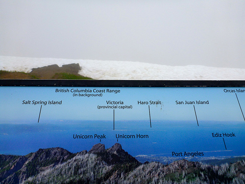
Mount Angeles is the highest point between Hurricane Ridge and the Strait of Juan De Fuca in Olympic National Park.

It offers incredible views from Canada to Mount Olympus.

It is only about 15 miles from the town of Port Angeles and is a very popular climb, both in winter and summer.

Summer offers a hike and a scramble to the top while winter offers a nice fairly easy snowclimb with a short easy chute at the end to the summit. Because this is so close to the ocean, the mountains tend to dump a lot of moisture with nasty weather. It is after all how Hurricane Ridge got its name. …

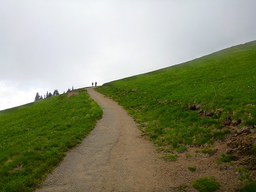
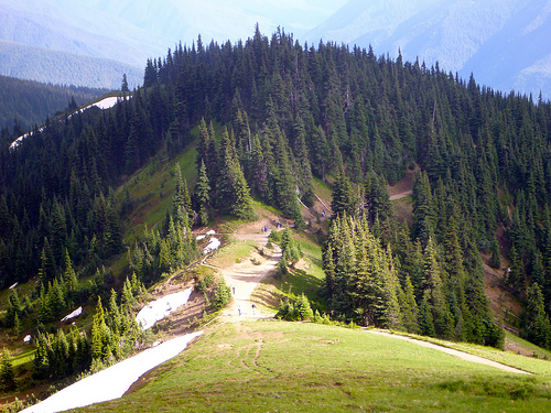
The main trail is the Mount Angeles Climbers’ Trail which switchbacks up the south side before switching over to the west side and then up a chute to the summit. There is an option on the East Ridge that offers some scrambling up the ridge to the summit. …

read more on Summit Post

Mt Angeles

I’d decided on a whim — after chatting with a descending runner on the Sunrise Ridge Trail — to try to climb the peak. Not knowing any better, I blasted straight up the face.

 6454 ft
6454 ft

I took the “easy” way down. Slowly and carefully. Descending is far more dangerous than climbing.

No water. Some report mosquitoes though I had none the day I climbed.

Given its close proximity to the Hurricane Ridge Visitor Center, the climbers’ trail route is frequently climbed by determined hikers, and even a few tourists manage to reach the summit, although the mountain is far too craggy and exposed to recommend it to any but experienced scramblers.

Accidents due to slips and falls on loose rock and snow account for many accidents on Mount Angeles.

Climbing Washington

hiking Hurricane, Olympics WA

At an elevation of 5,242 feet (1,598 m), Hurricane Ridge is a year-round destination. In summer, visitors come for views of the Olympic Mountains, as well as for superb hiking. …

Spectacular views of the Olympic National Park can be seen from the Hurricane Ridge viewpoint. The road leading west from the Hurricane Ridge visitor center is dotted with picnic areas and trail heads.

A paved trail called the Hurricane hill trail is popular with visitors, and is about 1.6 miles long (one-way) with an elevation gain of about 700 ft. It is not uncommon to find snow on the trails even as late as July. …

Hurricane Ridge is named for its intense gales and winds. The weather in the Olympic Mountains is unpredictable …

Don’t drive up the mountain before checking weather conditions.

Hurricane Hill is great.

Hurricane

Hurricane cloud

Sadly I got the the more typical vista when looking north to Canada. Nothing but cloud.

map

It started to clear as I descended.

descending Hurricane

Most visitors drive up. Take one of the wheelchair accessible walks, consume 1000+ calories at the snack bar. And drive on.

The biggest problem at Hurricane ridge, is this.

deer photo

Many wild animals get accustomed to humans. There’s supposedly never been a bear encounter in the park, but there have been animal encounters.

For example … A deer first followed. And then charged a leashed dog.

Click PLAY or watch it on YouTube.

Owner not much help. 😦

In bright sunshine, however, it’s difficult to beat Hurricane Ridge. I like it even better than Logan Pass, the equivalent at Glacier National Park.

hiking Hurricane

more of my photos from Hurricane Ridge

flickr photos tagged “Hurricane Ridge”

Clever Hiker – video tutorials

Our 10 episode video series – Lightweight & Ultralight Backpacking Foundations – and our Gear Recommendations eBook are the complete learning package for any backpacker interested in lightweight backpacking, thru-hiking, or simply carrying a more comfortable pack.

$24.95
details

Click PLAY or watch an introduction YouTube.

don’t trek Pakistan

😦

The mountaineering community continues to be stunned by the events that took place in Base Camp on Nanga Parbat this past weekend. Late Saturday evening or early Sunday morning a group of armed militants stormed the camp, grabbed several foreign climbers, tied them up and shot them in the back of the head, execution style. This left 11 dead, including a Pakistani guide and a cook. The names of the fallen are as follows.

Ukrainian Victims:
Igor Svergun
Kashaev Magomedovich Badawi
Konyaev Dmitry Sergeyevich

Chinese Victims:
Rao Jianfeng
Yang Chunfeng
Honglu Chen (held dual US/China citizenship)

Lithuanian Victim:
Ernestas Marksaitis (ExWeb says he was the only member of his team in BC, the rest were in Camp 1)

Slovakian Victims:
Anton Dobes
Peter Sperka

Nepali Victim:
Sona Sherpa

Kraig Becker

Huayhuash Circuit, Peru

I hiked Huayhuash in 2004. (annotated PHOTOS) It’s my BEST HIKE to date.

Extreme.

I recommend it only to the most experienced and adventurous trekkers.

Much better is a detailed 2010 trip report by ramblin’ boy:

huayhuash-from-above-shot

… The satellite image above shows you the mini-range of Huayhuash in the shape of a T; it is about 30 kilometers from one end to the other with six peaks over 6000 meters and a couple of dozen over 5000. It’s like walking in Sagarmatha National Park but without the prayer flags!

Most of the 125-km long trek is on trails above 4000m and above the tree line so you have a very stark mountain scenery. …

Huayhuash map

Our trek began with a ride to the new trail head at Llamac in a mini-bus with room for the seven clients, the two guides and cook and his assistant and a whole lot of tenting equipement and food. …

At Llamac we met the arrieros (muleteers) and their burros, all ten of them. They would carry the bulk of our stuff for us; we would walk with day packs containing rain gear, cameras, and a water bottle. I cannot imagine doing this particular trek unsupported, weighed down by all the things you’d need to bring. …

Huayhuash lakes

read on – The Huayhuash Circuit: South America’s Finest High-Altitude Trek

Those marvelous 15 days cost only $1350 / person. A great deal since they had a larger group.

They did the Circuit plus climbs of two trekking peaks: Pumarinri and Diablo Mudo.

Sweet.

Check our  Huayhuash information page.

erecting tents in the rain

Warren Long:

Figured that I might as well see how it was to set up our (expected) West Coast Trail tents in the rain. This was a good thing to do. The good tent got pretty wet inside, before I got the fly on. Next time I will be much faster getting the fly on correctly the first time….

The old tent is old, and the fly is no longer water tight. I ended up with puddles inside it after it had been in the rain for a few hours. I have now purchased and sprayed on some new waterproofing. Time for another test.

Click PLAY or watch it on YouTube.

training to HIKE

We have 11 spots booked for August on our #1 hike — the West Coast Trail.

Four of us did it together in 1999.

Warren got us out today for a “TRAINING hike”.

Warren

We marched the bank of the North Saskatchewan river.

North Saskatchewan

3.5km with full packs? … That ought to be enough. Right? 🙂

hikers

WCT hikers

See more photos from this grueling training session.

why I sleep in a tent, if I can …

… there may be a big disadvantage to sleeping in a shelter versus choosing a tent. Hantavirus! This nasty affliction is spread by rodents, especially mice. Mice habituate shelters, and hikers tolerate them. …

Take a Long Hike – Shelter or Tent?

tent

Privacy – You aren’t a stuffed sardine when it gets crowded.

Warmth – A tent with a rainfly is warmer than an open shelter.

Better Sleep – You are not poked, or kicked, or outsnored.

No Mice – Those critters can drive you nuts!

Ganden to Samye, Tibet

 
Unforgettable trekking in one of the most beautiful areas of Tibet. A pilgrimage between two holy sites.

Ganden Monastery to Samye Monastery.

Ganden

AT A GLANCE

  • one of the most popular treks in Tibet
  • 4-5 days
  • best months April – October
  • tenting is required
  • independent hiking is illegal, though some foreigners do it anyway
  • Ganden Monastery 4,300m to Samye 3540m  is a traditional pilgrimage route
  • you’ll suffer many hassles traveling in totalitarian China

Map.ChinaTibetread more on our new Ganden to Samye information page

We’ve updated (and moved) that page.

It’s been 15 years since we’ve done it. Leave a comment if you know of a more recent trip report.

fatal mountain goat attack 2010

A federal judge has dismissed most of a widow’s claims against the federal government after her husband was killed by a mountain goat while hiking in Olympic National Park

Robert Boardman, 63, of Port Angeles was trying to protect his wife and other hikers when the 370-pound male mountain goat fatally gored him in the thigh on a trail at Klahhane Ridge on Oct. 16, 2010.

Robert

The goat is believed to have been one that harassed hikers in the park for years …

The mountain goat then stood over Boardman for about 30 minutes, staring and pawing at the ground, making it impossible for … hikers to reach him, according to park ranger reports of the incident.

Boardman died from blood loss in about five minutes, the reports said. The goat was later shot and killed by a ranger. …

A necropsy on the animal showed it was healthy and in rut for the mating season …

After Boardman’s death, park rangers warned hikers to keep at least 50 yards away from goats and not to urinate on trails.

The park said the urine creates a long salt lick, attracting the animals. …

Federal judge dismisses most lawsuit claims in fatal mountain goat attack in Olympic National Park

Lake Angeles trailhead

Park Rangers have shot aggressive Elk in the past. But this is not typical of mountain goats.

I’m content the law suit was not successful.

This death has changed regulations, however.

… an Olympic National Park ranger operating under new mountain goat management rules shot and killed a mountain goat that had refused to leave a campsite near the park’s Upper Royal Basin for three days. …

related – What should you do if you’re attacked by a mountain goat?