Jason was frustrated organizing his own trek, unable to find all the information he wanted in one place. The book took him over a year to write, research and has been professionally edited.
Cost is only $9.50 in PDF format. Carry it on any portable electronic device.
Mosi-oa-Tunya National Park is an UNESCO World Heritage site that is home to one half of the Mosi-oa-Tunya — ‘The Smoke Which Thunders‘ — known worldwide as Victoria Falls on the Zambezi River.
The river forms the border between Zambia and Zimbabwe, so the falls are shared by the two countries, and the park is ‘twin’ to the Victoria Falls National Park on the Zimbabwean side. …
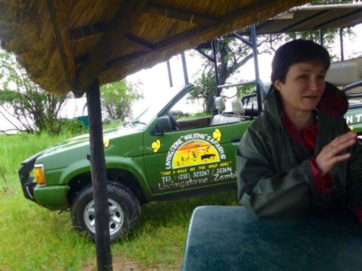
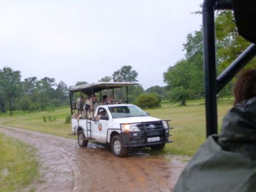
The wildlife section of the park is tiny but popular. Popular because half day walking safaris are offered.
This is rare in Africa due to the risk of tourists being injured. Or eaten.
It was very early. Very rainy when I was picked up — alone — at my hostel.
We rendezvoused with a British couple alongside the Zambezi.
Everything was about to go wrong. You had to laugh.
The husband had 2 new hips, 1 new knee. He could not walk.
Improvising, we decided to take a quick driving safari before setting out on the promised “walk”.
African guides are normally super entertaining. Very knowledgeable.
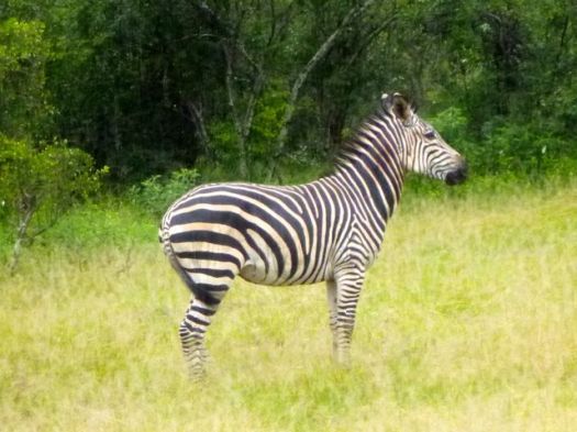
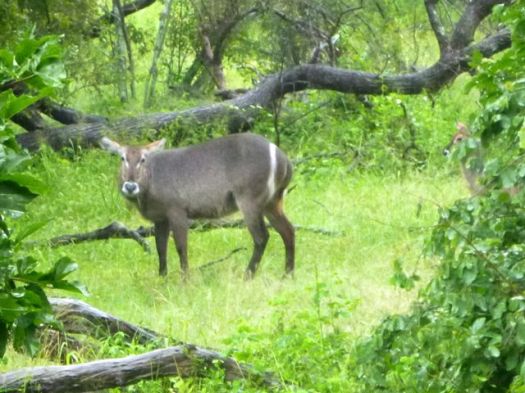
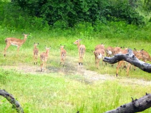
We saw baboon, vervet monkey, giraffe, zebra, warthog, sable, impala and many other antelope.
When the British couple departed, I was alone for the walking Safari with a support team of up to 4 men.
I walked with a guide and an armed guard.
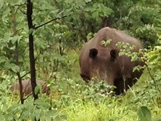
There’s no shortage of wildlife in Mosi-oa-Tunya National Park. But the main attraction is white Rhino. Though not indigenous, they are the most talked about wildlife in Africa.
You cannot see rhino from the road. They are understandably very shy.
Already an hour or more late, we roamed far and wide in the wet mud looking for rhino sign. The guard checked his phone constantly for an update on where we might find them.
Finally, the highlight of Mosi-oa-Tunya. A mother Rhino and her new baby, less than 2 weeks old.
The rhino in Mosi-oa-Tunya were poached to extinction in 2007. 😦
I was told they are no longer worried about poaching here. The Park is now fiercely defended. 5 adult rhino and 5 youngsters, including this newborn.
On the other hand, the enforcement officer spoke longingly of Botswana where guards can (reportedly) shoot poachers on sight.
This new backcountry survival Android tablet works where your smartphone or iPad would fail. The rugged tablet can forecast the weather, determine your location, elevation, and let you communicate with folks back home.
About the size of an iPad mini, Earl is one tough gadget. It’s waterproof, dustproof, shockproof, and it will work in temperatures from 32 degrees to 122 degrees Fahrenheit. You can submerge it in three feet of water for up to 30 minutes with no ill effects.
Earl’s GPS uses an internal magnetometer, accelerometer, and gyroscope to track your position. It’ll guide you even if you’re navigating dense vegetation or an urban jungle without a line of site. It also gives you access to more than 300,000 trails through the site everytrail.com and high-resolution topographical maps of North America. With Earl in your hand, you have no excuse to get (unintentionally) lost. …
We enjoyed one of the better toilets here, however.
Sawdust does help reduce odour.
Seems the expensive solar composting toilets (used in the past) are no longer “must have” technology.
Hicham dressing for battle.
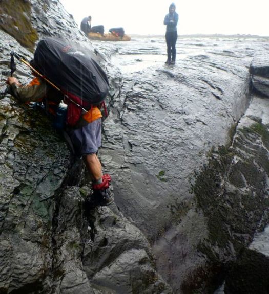
We faced the most dangerous section of the West Coast Trail — dread Adrenaline Surge.
Our arrival was perfectly timed for low tide.
Two choices. Down and back up? … Or scramble around?
We opted to stay high rather than risk a freak wave flushing us out to sea. That had happened to a friend of ours in the past. (She was washed back into the Surge on the next wave. And pulled to safety.)
All 11 made the traverse safely. But it was very, very slippery.
If not confident in your agility, take the inland route, instead.
On the other hand, in good conditions, at low tide, the coast can be like a sidewalk. Sandy and myself ALWAYS voted to take the coastal route. Vistas are magnificent.
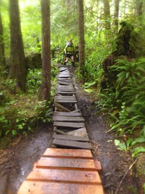
The first word that comes to mind when describing the WCT is … LADDERS.
There are MANY. Some are LONG and STEEP.
This is no adventure for those afraid of heights.
The second word that comes to mind is … RAIN.
The WCT is no place for those afraid of slipping on wet surfaces.
Nor those who don’t like to get dirty.
Actually, we had only a few hours of rain. This was a relatively dry week on the Wet Coast Trail.
Any idiot can hike when it’s dry. It takes experience and expertise to enjoy camping in the rain.
While checking into the hostel, sign up for their most popular guided hike. It’s offered about every 2nd day for about $50 all inclusive.
7:30am departure.
Here’s our guide “Sim” parking one of the hiker shuttle vans at Sentinel car park 2,500m (8,200 ft). This is the only official day hiking trail leading to the top of the Drakensberg escarpment.
Yep. That’s the Sentinel. You cannot climb it without ropes. We’ll skirt the base.
The trail zigzags up towards the big peak. Then traverses right.
Entirely above the treeline, we did not see much in the way of wildlife. Aside from lizards, of course.
It was an easy start with perfect weather.
One short ladder on the ascent.
The crux of the hike is up this gorge.
It’s a 300m scramble. Not too difficult overall.
Atop the Amphitheater cliffs, we stopped for lunch. Our guides were disappointed that clouds obscured the fantastic views.
Note the big birds that stopped for lunch with us.
The 1990s saw the beginning of the Nepalese Civil War (1996–2006), a conflict fought between government forces and the insurgent forces of the Communist Party of Nepal (Maoist). The situation for the Nepalese monarchy was further destabilised by the 2001 Nepalese royal massacre, in which Crown Prince Dipendra reportedly shot and killed ten people, including his father King Birendra, and was himself mortally wounded by what was allegedly a self-inflicted gunshot.
As a result of the massacre, King Gyanendra returned to the throne. His imposition of direct rule in 2005 provoked a protest movement unifying the Maoist insurgency and pro-democracy activists. He was eventually forced to restore Nepal’s House of Representatives, which in 2007 adopted an interim constitution greatly restricting the powers of the Nepalese monarchy. Following an election held the next year, the Nepalese Constituent Assembly formally abolished the kingdom in its first session on 28 May 2008, declaring in its place the establishment of the Federal Democratic Republic of Nepal. …
The monarchy had governed poorly, not modernizing. A Republic will, hopefully, be an improvement.
The Nepalese Royal Family as seen in this 1989 photo at the Narayanhiti Palace in Kathmandu. The royal members, from left to right, were Crown Prince Dipendra, King Birendra, Prince Nirajan, Queen Aiswarya and Princes Shruti. An eyewitness to Nepal’s palace bloodbath said on June 7, 2001, the late Crown Prince Dipendra staggered and fell occasionally as he drunkenly mowed down most of his family in just over a minute. (Reuters)
The drunken son used 3 different automatic weapons to mow down his family. No doubt American Gundamentalists found a way to defend his access to those weapons.
The Nepalese Constituent Assembly was … formed as a result of the Constituent Assembly election that was held on April 10, 2008 in Nepal. …
The Communist Party of Nepal (Maoist) (CPN (M)) was the largest party in the Constituent Assembly, having won half of the constituency seats and about 30% of proportional representation seats. …
Prachanda … is a Nepali politician and Chairman of the Unified Communist Party of Nepal (Maoist) (UCPNM). He led a guerrilla war against the government and later served as Prime Minister of Nepal from 2008 to 2009. …
Power corrupts. Once Prachanda was in charge he took residence in a 15-room mansion and started living a wealthy lifestyle. …
Bottom line. Prachanda and the (Maoist) (CPN (M)) party was no more effective in leadership than the monarchy.
In the Nov. 2013 election Prachanda and his party came a distant 3rd.
The centrist Nepali Congress, the Himalayan nation’s oldest party, established itself as the largest group in the 601-member constituent assembly, winning 196 seats …
3:00am breakfast … terrible oatmeal, OK pancake, litre of coffee
3:30am intended start
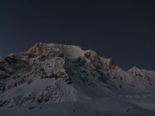
We actually got going nearer to 4am. And it’s plenty cold standing around in the dark.
I was counting on a bright full moon.
Sadly for me, it had set long before 4am.
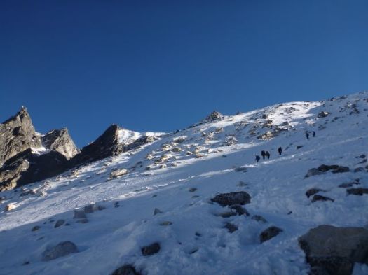
Finally setting off, we attempted to catch Tasha and Ivan. Breathing was difficult. Vision was worse. I finally had to step out of line to change batteries in my headlamp.
This first 45min was the worst part of the Manaslu Circuit for me, so far. 😦
Whilst moving, you are not cold.
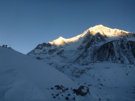
Things got better as the sky lightened.
Glorious when the sun finally appeared atop the high peaks.
It was good to be alive when sunshine hits you in the face this high up.
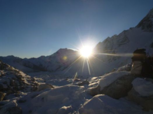
At this point we were completely confident in crossing Larkya. We could relax.
This was like any winter in my Canadian Great White North.
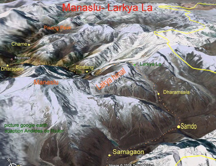
We were surprised how quickly we reached Larkya La5106m (16,751ft).
Ivan and Tasha
We’d started early to avoid severe wind here. Happily, there was very little wind.
Actually, it was quite challenging on one long, steep section.
Porters, in particular, were slipping and falling. I can see why this Pass could be closed after a snow storm.
It’s a little more treacherous than it looks.
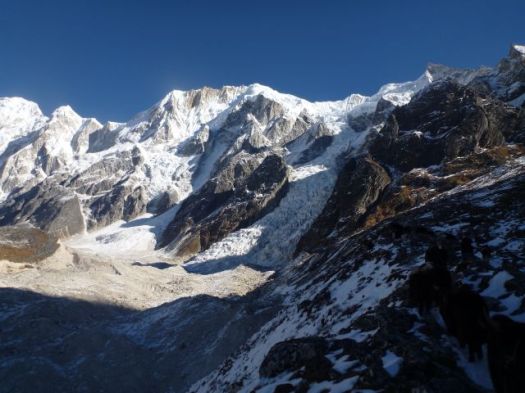
You skirt the glacier before getting back to reasonable footing.
Some make a side trip to visit the glacial lake. We skipped it.
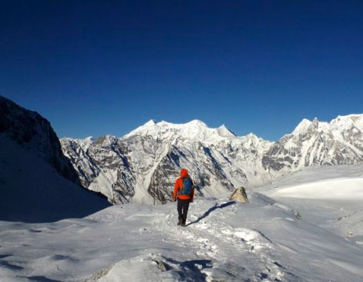
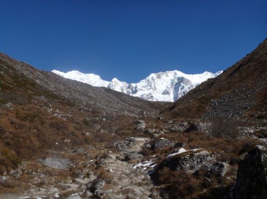
Once finally down down, the trail is easy.
Smiles on our faces, we arrived Bimtang 3720m.
Civilization.
That might be the finest guest house we saw on the Circuit. Private cabins. It was booked, of course. By large groups of French trekkers.
It was early in the day. Mike and I were the 3rd & 4th hikers to arrive. Tasha and Ivan were 1st & 2nd.
It takes most hikers 6-10hrs to make the crossing. Much longer, of course, if you start in Samdo rather than Larkya Phedi.
We took the chance to bathe in the sun. The river was flowing, but water taps at our guest house were frozen.
And do some laundry.
I again walked the moraine ridge above Camp at sunset. But it wasn’t nearly as inspiring as the night before. Things are a bit anticlimactic after crossing the Pass.
We chatted through dinner. Went to bed early. I slept 11hrs straight through.
Note: One woman had fallen the day before we crossed the Pass. Hit her head. Though continuing immediately, she had a suspected concussion. She was resting in Bintang. Make sure your travel insurance covers hiking at altitude.
This is why you want to trek in November / early December.
Mike and I were happy to have the weather. Wanted to get up and over the Pass as soon as possible. If he were to have to backtrack to the start, he’d miss his flight back to the U.K.
The arid terrain that high up was very Tibetan.
Not much can live in this climate. Yet Yaks thrive.
The scenery is fantastic. You hike closer to the big peaks than anywhere else I’ve been in Nepal.
I was one happy hiker.
Some trek from Samo only to Samdo 3690m. Then make a long, long day climbing over the 5106m Larkya Pass.
Sounds crazy to me. But it worked for a German couple we had been hiking with. Their guide doesn’ t like Larkya Phedi 4470m (Dharmsala).
Larkya Phedi is a harsh place. In every way.
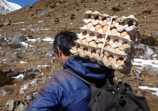
It was closed by MCAP in 2011 for being an “illegal structure”. But open since. Open normally until about Dec 15th each season. Food sometimes runs out before that date, however. Some years hikers eat nothing but potatoes before crossing the Pass.
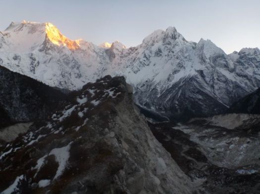
We knew fresh eggs had arrived.
Larkya Phedi is the last place you can sleep with a roof over your head. … On the other hand, there were no beds left when we arrived. When the Pass is closed, it gets very crowded here. 😦
We set up my tent on a snow patch.I wouldn’t be getting much sleep anyway. Wake-up time would be 2am.
Hikers tried to relax in the sun. Nap if they could.
It got very cold as the sun went down.
Toilets are overflowing with feces. They don’t stink. They are frozen.
Ivan saw one Nepali shit into the stream above Camp. The only source of drinking water. That’s how uneducated some of the porters are. That’s why the water is so dangerous in Nepal.
We walked the ridge above Camp for acclimatization. And to stay warm. There were dozens of Blue Sheep up there. Until hikers scared them away.
I practiced various speeds walking both uphill and downhill to maintain an optimal temperature. This in anticipation of the Pass, considered much more difficult than Thorung La on Annapurna.
Wandering alone up there until dark, this was the single highlight of the entire trek for me. 🙂
Wonderful.
Mike and I lingered in the dining hall as late as we possibly could. Staying warm. And avoiding our cold tents. Mike and our guide were forced to share a rent a tent as all beds were taken. Porters slept on these tables and benches starting 10pm.
Last minute I ordered hot water for my Nalgene bottle, using it inside my sleeping bag to warm my feet. Temperature dropped to at least -15C. (5F)


 Civilization.