Sunshine Coast Trail – day 3

trip report by site editor Rick McCharles

Tin Hat Mountain to Elk Lake

day 1 | 2 | 3 | 4 | Sunshine Coast Trail information page

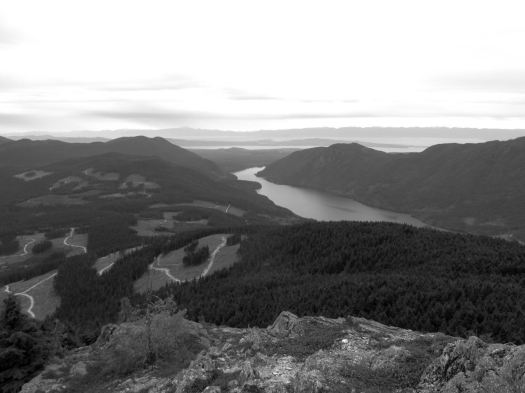
… the Tin Hat hut is an epic 360-degree mountain-top lookout that provides the quintessential view of the rugged mountains, valleys, and lakes that define the Powell River back country experience. This hut is a fully winterized cabin with pellet stove and is located in, arguably, one of the most beautiful spots on the Sunshine Coast Trail. Although it is a climb to get there, the experience is well worth the effort. Summitting this mountain will make you feel like you are, indeed, on top of the world!

tinhat_2

It’s the highest elevation point and the biggest attraction of the SCT. I was impressed.

IMG_0438

IMG_0437

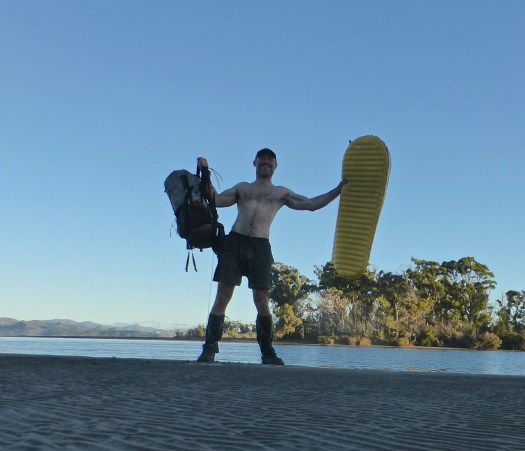
Still early morning, I chatted with Lisa from Calgary in the hut. Then dashed on back down the logging road to where I’d stashed my pack. A savvy hiker like myself doesn’t haul his gear up the mountain unless absolutely necessary. My guidebook hinted at an alternative SCT route that would be easier than the normal steep up and down. 🙂

I was soon lost. 😦

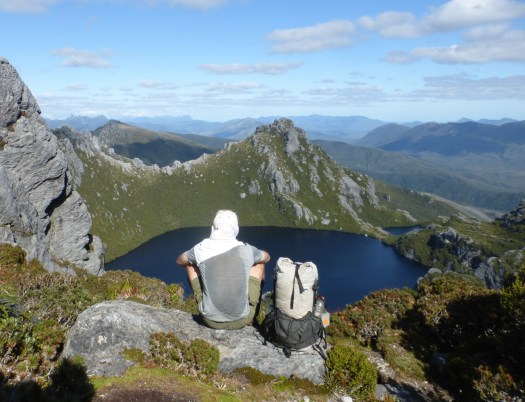
Views were terrific.

IMG_0436

But I found myself on a maze of logging road switchbacks. If you don’t like clear cut, you might not like the Sunshine Coast Trail.

IMG_0440

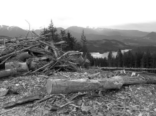
Here you can see an old growth survivor. Secondary growth. And the war zone that is clear cut logging.

IMG_0441

Worse than forest devastation, the bugs.

bug shirt
bug shirt

By day 3 I wore my bug shirt non-stop. Flying pests are a very good argument why you should NOT hike the Sunshine Coast Trail. All of the other major B.C. coastal hikes have virtually no bugs

Eventually I found my way back to the SCT.
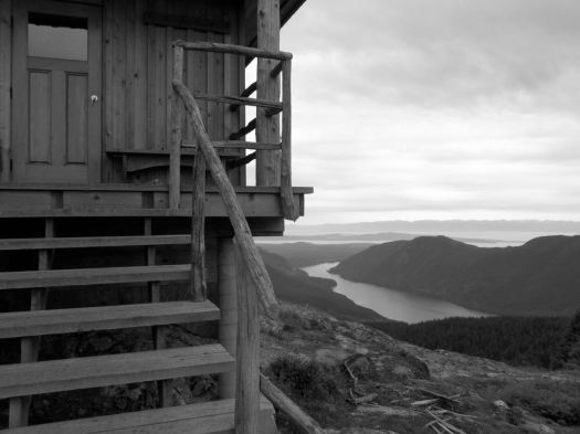
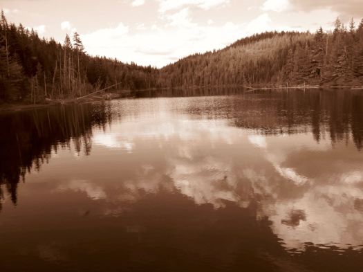
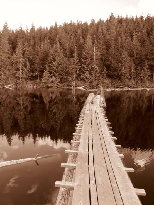
IMG_0445

Past Lewis Lake.

IMG_0446

On to Elk Lake.

Elk-Lake-summer

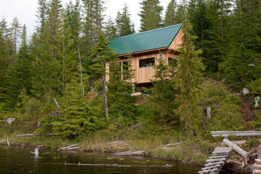
Mosquitos and I had the rustic hut to ourselves. Very tranquil.

IMG_0466

IMG_0467

IMG_0470

Close to dark Alex from Ontario rushed in. Super happy to have made it to the hut in daylight. She’d come from Tin Hat Hut.

day 1 | 2 | 3 | 4 | Sunshine Coast Trail information page

Sunshine Coast Trail – day 1

trip report by site editor Rick McCharles

Mowat Bay to Inland Lake

My camera had multiple problems on this trip. Photos are inconsistent, at best. 😦

day 1 | 2 | 3 | 4 | Sunshine Coast Trail information page

AT A GLANCE

  • the best jumping off point for the SCT is Powell River, close to Vancouver B.C.
  • the Sunshine Coast is less rainy than the rest of the lower mainland, but can still be very wet
  • up to 180km (112mi)
  • possible to hike hut to hut without carrying a tent
  • huts “first-come, first-sleep”. Each can accommodate at least 12 hikers. More huts are being added.
  • Canada’s longest hut to hut hiking trail
  • NO permits or reservation required
  • free 🙂
  • it’s considered B.C.’s hidden gem of hiking routes. Many have not yet heard of this adventure.
  • recommended to carry a tent as a back-up. There are many scenarios which might cause you not to reach the next hut on any given day.

I caught the 10am ferry from Comox, Vancouver Island to Powell River.

sunshine-coast-map

My plan was to do the big central section. About 90km.

newmap

July 2015 we’d hired a boat to drop us at the northern trailhead Sarah Point. But quit the hike at Manzanita Hut after only 2 days. Driven out by mosquitos and wasps.

Could have taken a local bus to a trailhead, but instead walked from the ferry about 5km through town to Mowat Bay.

IMG_0392

Here’s pretty Cranberry Lake in Powell River town.

IMG_0394

Lovely day to start a hike. 🙂

Mowat Bay is close to sea level. It’s uphill from here.

IMG_0395

Alder loves to overgrow the relatively little used trails. Blow downs are more frequent than are volunteers with chain saws. It’s rugged and challenging hiking. But pretty.

IMG_0431

I ended up paying $5 to camp on Anthony Island. I slept in my tent.

IMG_0413

A Danish couple took the hut.

IMG_0416

They made dough from flour. Then wrapped it around a green branch to cook over the open fire. A Danish tradition, I understand. Burnt on the outside, raw on the inside. 🙂


day 1 | 2 | 3 | 4 | Sunshine Coast Trail information page

1997 trek to the Lost City,

trip report by besthike editor Rick McCharles

Santa Marta, the oldest city in Colombia (1525), is pretty & undeveloped. Backpackers love this place. Cobble-stoned houses, overhanging balconies, churches and military fortresses. Kids, dogs, pool halls, power failures and loud music.

It is the jumping off point for the Lost City trek.

I was psyched.

jlost_riverSix-day return treks to the ruins of La Ciudad Perdida are only allowed through a government agency. Guides arrange transport, food and accommodation — essential because the area is a significant marijuana and coca-growing region.

I, like the other backpackers in Santa Marta, was nervous about making the trip.

A selling point, however, was that hikers of all nationalities were allowed to trek except Americans — they make too attractive kidnap victims.

k_guideOur guide was most famous and experienced having made the trip over 500 times since the Lost City had been rediscovered in 1976.

I carried my tent on the trek, much to the consternation of my old guide. He insisted we sleep in hammocks in the South American tradition.

read more

remote Mount Edziza, British Columbia

This is a relatively unknown trek in British Columbia, maybe receiving around 30 visitors each season.

Every day of the trek is different from the other, passing through mountain valleys of incredible orange and red mineralizations to volcanic plateaus littered with cinder cones and fine sandy pumice.

Mt. Edziza and the Spectrum range are located in the Mt. Edziza Provincial Park in the Tahltan First Nation territory of northern British Columbia, 35 km. west (by air) of Highway 37 at Tatogga Lake. From the air, you can see where the lava poured across the plateau and down through the trees to the lakes and creeks below. Normally, trekkers undertake one section at a time – either a 5-day trip along the Edziza plateau or a 5-day trip through the Spectrum range. For either one of these 5-day treks, most people fly out from Mowdade lake which is roughly the dividing line between the Edziza and Spectrum regions.

Trekking Partners – One of the most beautiful treks in BC

mt-edziza-provincial-park-02-alex-buri mt-edziza-provincial-park-07-alex-buri

From the Vancouver airport you might be able to drive to Telegraph Creek, BC in 24 hours.   This adventure truly is remote.

Edziza


Adventure Junkies – Huayhuash trek, Peru

… The snow-capped peaks here are really high (many well over 6.000 mts – 19,500 ft) and the feeling of remoteness is fantastic. …

The whole circuit takes anywhere from 8 to 14 days to complete as there are different routes available. There is only one small town where you can re-stock on supplies which means you will need to carry all your food for 7-8 days if walking independently.

For that reason, most of the hikers decide to go with an organized tour. But hey, we are the Adventure Junkies. We can’t let a donkey carry our stuff up the mountain!

HIKING THE INCREDIBLE HUAYHUASH CIRCUIT IN PERU

Day-2-Laguna-Camp-Amanda-1-of-1

Check out our Huayhuash Circuit information page.

Manaslu Circuit after the earthquake

Nepal Explore Summit Treks reports Manasulu is back in business.

From Manaslu Conservation Area Project (MCAP) entry point Jaget, only 25 tourists made it to Manaslu circuit since the earthquake happened …

However, as the trail improved in the area, by middle of November (2015), this number already went up to more than 5000.  And to date, based on statistics, approximately 40 trekkers enter the Jaget point on a daily basis. …

… Bridges wiped out by the landslides have been rebuilt by the villagers.  The trail is open again for trekkers to explore. …

read more

repairing the trail
repairing the trail

toughest hike of the year?

Southwest Tasmania Traverse

Cam Honan:

Between February 27 and March 22 of this year, I completed a traverse of the southwestern region of the state. One of the wildest, most pristine backcountry areas on the planet, it was a hike I had dreamed of doing for almost two decades. …

200 miles (322 km) approx. …

Time: 24 days

Daily Average: 8 miles (13 km) approx. This included one rest/resupply day. Hiking, scrambling, bushwhacking, climbing, paddling, crawling, swimming, rock hopping…………yep……..the terrain really was that challenging …

The Hiking Life

SW-Tassie-overview

thirteen days food
13 days food

Lake-Oberon

Celebrating after paddling the 150 metres crossing between Piners and Settlement Points on my Thermarest NeoAir. My backpack floated behind, attached with some guyline to my right leg.


15 Benefits of Hiking

Tom Mangan:

Benefit One – Improve Your Overall Health and Be Fit!

Benefit Three – Be Happy!

Benefit Five – Increase Your Energy Level!

15 Benefits of Hiking – Get on the Path to Longevity Today!

Click through to read the rest.

Tom Mangan
Tom Mangan

Tom was the first hiking blogger I followed. His Two-Heel Drive is a terrific resource.