Chili volcanos – Villarrica Traverse day 1

trip report by site editor Rick McCharles 

day 0 | 1 | 2 | 3 | 4 | 5 | Traverse info page

Pucón > Ski Centro > Estero Nilfe

From Pucón we decided to take a taxi up to the Park gates. Much easier than hitchhiking.

The Ranger opened the Villarrica National Park office for us. He’d formerly worked in a Canadian National Park. I chatted with his wife who’s from my hometown, Calgary.

IMG_0010

CONAF charges an entrance fee of Ch$5000 to Chileans or Ch$7000 ($10) to foreigners (2016) for using the “Villarrica Traverse”.

Happily we were able to hitchhike the final 17km up to the (ugly in summer) ski resort, the official start of the Traverse.

IMG_0014

Slightly overcast (as it often is in the morning in Chile) we quickly headed off into the great blue yonder.

IMG_0019

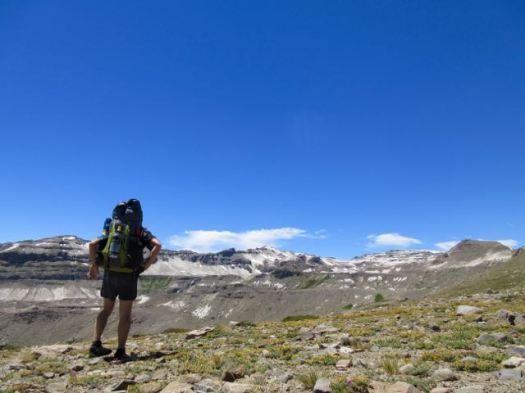
At this point we were literally traversing the volcano. The landscape bleak and blasted. I’d met Victor and Pedro, 2 Brazilian music students, while hiking further north. They decided to join up with me for this BIG and HIGH walk.

IMG_0021

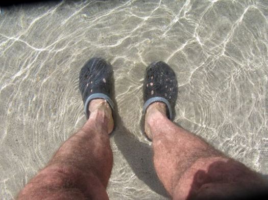
My lunch for the first few days was cheddar and buns.

IMG_0022

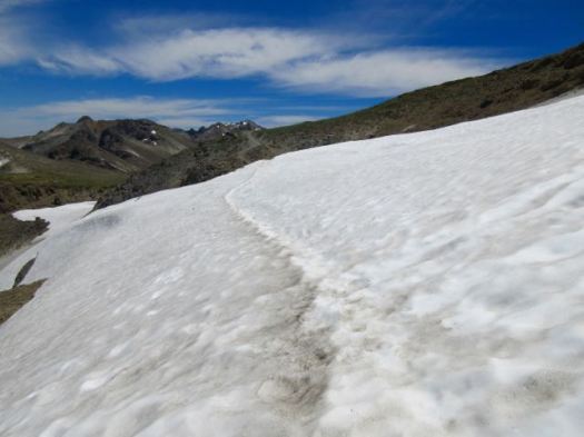
Navigation is very easy on this adventure. Follow the stakes. 🙂

IMG_0024

Sadly I still managed to get us lost for perhaps 90 minutes. 😦 When we finally found our way back to the correct route we moved and replaced stakes so nobody else would make my mistake.

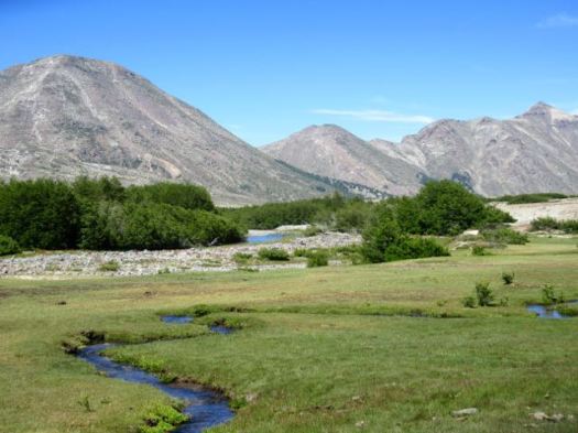
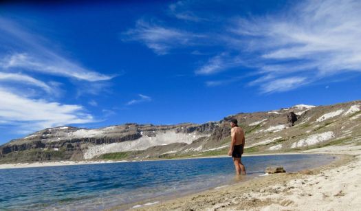
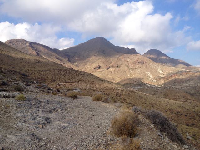
Finally the clouds blew off and we got our first good close-up look at Villarrica 2847m. It’s the most climbed volcano in Chile.

IMG_0027

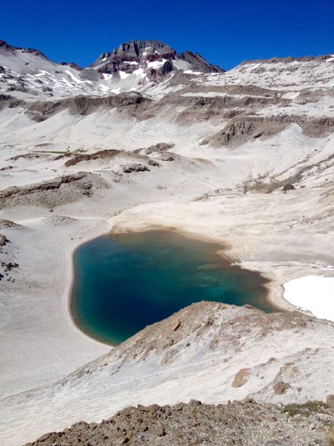
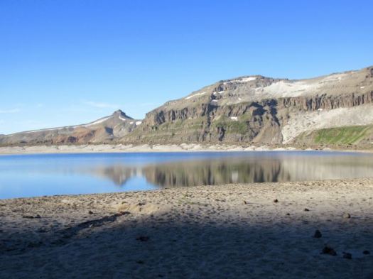
Water is a concern. Anything close to the volcano is dirty with ash.

IMG_0028

Whenever you find clean water, load up.

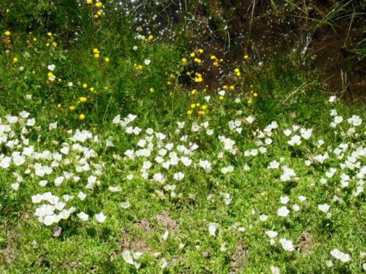
Still, water is life. Vegetation regrows only with water.

IMG_0030

The Monkey Puzzle trees are a great highlight of this hike. They are the national tree of Chile.

IMG_0031

IMG_0032

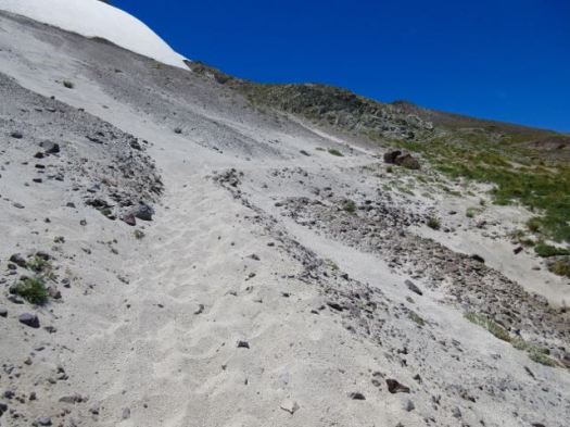
Footing is often difficult in volcanic scoria. Don’t fall.

IMG_0040

With so much exposure to the sun, it was always a relief to reach shade.

IMG_0045

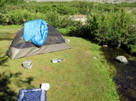
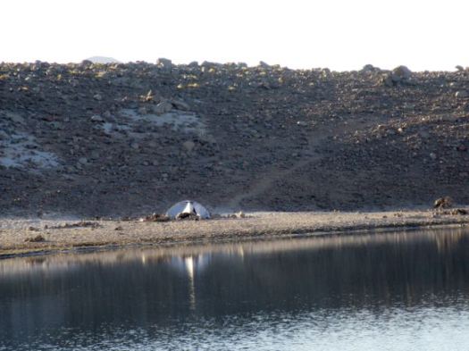
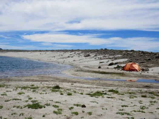
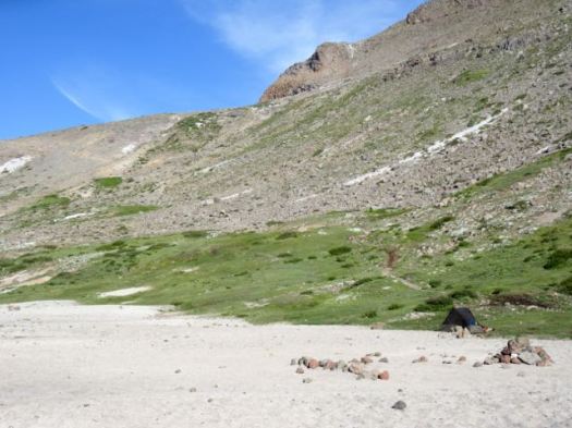
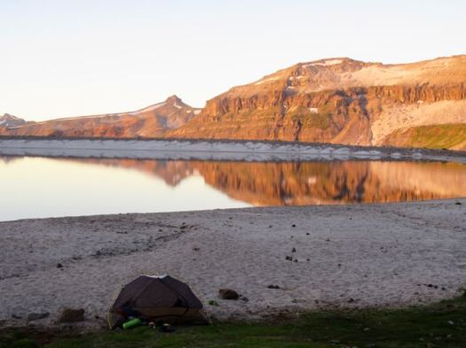
We camped at the spot recommended by Lonely Planet. Can’t complain about the view. 🙂

Victor, Pedro, Rick
Victor, Pedro, Rick

I didn’t like the water, however, so walked back to a tarn for perhaps 30 minutes. We did treat a lot of water on this hike.

IMG_0057

Good night. It was a great start.

IMG_0058

day 0 | 1 | 2 | 3 | 4 | 5 | Traverse info page

day 5 – Laguna Ánimas to Molina

trip report by besthike editor Rick McCharles

day 0 | 1 | 2 | 3 | 4 | 5 | info Condor Circuit  

I had a long way to go today. But it was mostly downhill.

IMG_4231

Back past Laguna Ánimas, busier than when I had camped here.

IMG_4234

Two large water birds seem to spend their nights here.

IMG_4236

The easy way to descend snow fields.

IMG_4243

IMG_4244

Though I’m afraid of riding horses, Chile is ideal country for cowboys.

IMG_4249

Back to the green. And some shade.

IMG_4253

Impressive Bolsón was packed. This great weather had inspired more folks from Santiago to takes some time off work.

IMG_4260

IMG_4261

This day I did see two large hares, the only indigenous mammals I found.

Surprisingly I saw no sign of snakes or scorpions. Or rodents. My principle companions were tens of thousands of these guys.

IMG_4265

On the trail the only language I heard was Spanish. Foreign hikers do not seem to get here much. It’s another Chilean secret. 🙂

Catching the Parque Inglés bus back to Molina, a tranquil town of about 40,000. I (eventually) found an inexpensive and interesting place to stay in the small town. With a BIG swimming pool.

Hostería Suichi (Suisse + Chile) run by Robert, a (now jaded) Swiss expat.

Robert gave me good information. And cooked up a beef soup typical of the region for me.

In the evening I ate ice cream and hung out in the plaza. As everyone does.

On the street late night I bumped into a Chilean couple on holiday who ended up staying at the Hostería. Next morning we had breakfast together in the popular restaurant. 🙂

Meeting new people is one of the great highlights of travel.

canada

day 0 | 1 | 2 | 3 | 4 | 5 | info Condor Circuit  

day 4 – return to Laguna Ánimas

trip report by besthike editor Rick McCharles

day 0 | 1 | 2 | 3 | 4 | 5 | info Condor Circuit  

Sunburn was my biggest worry at this point. I had plenty of No-Ad Sport Sunscreen slathered on, but this sun is unrelenting. I was wearing socks on my hands as they were most burnt, so far.

IMG_4178

I made one last climb up to the “corner” of the valley to see if it looped back over a pass in the direction I wanted to go …

The cows thought I was crazy.

IMG_4184

I was crazy. Odds were slim that it would work. I turned back here.

IMG_4187

It was a relief, actually, to finally know where I was going.

River crossings are a big issue here. There are no bridges. Happily this was the most difficult I crossed. Not bad.

IMG_4188

Descending to the hot springs, the group had already vacated. I had the place to myself. 🙂

IMG_4190

IMG_4197

One last look back up my side valley.

IMG_4198

Mid-day I took the shade and studied Spanish for 90 minutes or so. Then resumed my high traverse of the massif.

IMG_4202

Today the two condors came to check me out.

IMG_4207

IMG_4215

I was clinging to life yet. 🙂

IMG_4217

People curse slogging through ash. Personally, I like it. Very soft on the feet. The best screeing surface possible.

IMG_4218

I was surprised to come across 4 Chilean hikers in the afternoon. They had put up the tents and got directions from me to the hot springs. Two had just been married. This was part of the honeymoon. Both were just about to move to Montreal for work. Small world.

IMG_4220

One of the guys asked me if I knew the way back to the Pass. Of course I did. I’d just come from that direction.

How could I get lost? 🙂

IMG_4223

I got lost. 😦

Things truly do look completely different when walking the opposite direction.

My good camera had broken, the telescoping lens mechanism wrecked. 😦 I wasn’t in much of a mood to take photos in any case. 😦

My audio book – Red Rising by Pierce Brown – kept me going.

I was first diverted for about 2 hours. Then about 30 minutes. (Several times I considered backtracking to the honeymoon party tents. I could have walked out with them next morning.)

But – finally – I found the way back to Ánimas. I set up my tent above the lake at this junction of alpine meadow and desert. My best campsite.

IMG_4224

day 0 | 1 | 2 | 3 | 4 | 5 | info Condor Circuit  

day 3 – Laguna Ánimas to Hot Springs

trip report by besthike editor Rick McCharles

day 0 | 1 | 2 | 3 | 4 | 5 | info Condor Circuit  

Another lovely dawn. I packed up before the sun hit my tent. Fearing sunburn.

IMG_0472 IMG_4130

Pretty Laguna las Ánimas is a jewel in the midst of volcanic destruction.

IMG_4131

Atop the next plateau I was surprised to find yet another alpine meadow.

IMG_4132

If this region were not so volcanic, it would be very green.

Higher there was yet more water. But the scenery grew stark. Weird and wonderful.

IMG_4136

IMG_4135

IMG_4137

Looking back on my morning route.

IMG_4138

Above Ánimas there are no signs. No official trails. You are on your own. I’m sure people get lost and die here every year.

I hoped that was my highest pass up ahead.

IMG_4139

It was. 🙂 I left a Summit Stone.

IMG_4141

It would be an excellent idea to enjoy the massive and impressive Mt. Decapitated vista from here. And turn back.

Laguna Mondaca
Laguna Mondaca

IMG_4144

I dropped down to the other side crossing this field of snow and ash.

IMG_4145

Laguna Mondaca looked too great a descent for me. I’d really rather not drop down that far and have to climb back up.

A high traverse trail on the right looked much more tempting. Quickly I decided to stay as high as I could. Returning by the same route if that trail didn’t loop around back to Valle de Indio.

IMG_4148

I LOVE this kind of brutal & extreme landscape.

IMG_4147

IMG_4151

IMG_4153

Surprisingly, it’s quite easy to find water here.

IMG_4154

IMG_4155

Wildflowers were still thriving in January.

IMG_4159

IMG_4162

The unofficial trail was excellent. I stayed as high as I could.

Laguna Mondaca
Laguna Mondaca

Though I could see for miles in every direction, I’d seen no wild mammals at yet. Goats were grazing very high up, circled by two very interested condors.

IMG_0473

I tried to find some shade to take a siesta mid-day. This was one of the best.

IMG_4169

I set up the tent to keep flies and wasps away.

IMG_4174

This was a long but comparatively easy day, mostly gradually downhill. I decided to enter a side valley hoping it would loop back to where I started. (My GPS did not work and I had no map, so this was wild speculation.)

IMG_4175

Entering the valley I smelled sulphur. I’d stumbled on to one of the many natural hot springs in the area. But a horse group was already camped there. I decided to wait until next day to have my bath.

I set up high and out-of-sight since there were cattle and people in this valley.

IMG_4176

day 0 | 1 | 2 | 3 | 4 | 5 | info Condor Circuit  

day 2 – El Bolsón to Laguna las Ánimas

trip report by besthike editor Rick McCharles

day 0 | 1 | 2 | 3 | 4 | 5 | info Condor Circuit  

Good morning from the Andes.

IMG_0443 IMG_0447

There’s a reason Bolsón is so popular. It’s a pretty alpine meadow, a green oasis on the edge of a volcanic wasteland.

IMG_0444

IMG_0445

IMG_0446

Most who make it this far stop and day hike from here.

But I was determined to seeif not climbMt Decapitated. I’d have to get past that spiky peak in the distance to do so.

IMG_0448

On the other hand, I took it easy today ascending steeply up to the next obvious campsite. Past that the next recommend camp is Laguna Mondaca, too far for me with full pack, I was thinking.

The trail is clearly signed up to Valle de Indio, another lush alpine meadow. It’s gets more volcanic after this point.

IMG_0451

IMG_0449

Despite the heat and intense sun, snow crossings were frequent. Early season would require an ice axe.

IMG_0453

IMG_0455

Footing is either bad up here. Or volcanic ash. I used the “instagator” system with my socks.

IMG_0460

In South America you can expect to see at least one religious pilgrimage site every day.

IMG_0459

IMG_0458

The higher I climbed, the better I liked it.

IMG_0457

I arrived Ánimas before 3pm. With at least 5 hours of sunlight left, I was tempted to risk it and climb higher.

IMG_0468

Instead I cooled my heels. Listened to my Coffee Break Spanish lessons. Walked the perimeter of the tarn.

IMG_0462

Rick Chile

Not many carry tents up here from Bolsón, but there were a few groups with me at the lake.

IMG_0467

IMG_0461

Just above my tent is the trail I’ll take in the morning.

IMG_0464

Good night.

IMG_0469

IMG_0471

day 0 | 1 | 2 | 3 | 4 | 5 | info Condor Circuit  

day 1 – Parque Inglés to El Bolsón campground

trip report by besthike editor Rick McCharles 

day 0 | 1 | 2 | 3 | 4 | 5 | info Condor Circuit  

High season on a mid-summer weekend, Valle las Catas campground was full.

IMG_0417

We were in no rush. Enjoyed the morning.

Sendero Los Cipreses (Cypresss Trail) is free entrance from Valle las Catas campground leading to the Siete Tazas (7 cups). Pedro, Victor and myself did the famous tourist attraction as a day hike.

IMG_0423

seven consecutive natural pools with their respective waterfalls along Claro River. These waterfalls range from 1 to 10.5 metres. There are also two high waterfalls called El Velo de Novia (The Bridal Veil) and La Leona (The Lioness), with single vertical drops of 40 and 20 metres respectively. …

7 cups

On return to the campground I enjoyed one last restaurant meal – 4 eggs.

IMG_0424

By far the most popular back country campground in the area is El Bolsón. I planned an afternoon start. Tried to get organized at the Ranger station.

IMG_4272

IMG_0425

In fact it was 4pm before I reached the trailhead.

Christian and his family had been there before. I followed them from the Park office and we stayed together for much of the 12km. All uphill.

IMG_0432

Many groups ride horses up here. Or take pack animals.

IMG_0433

Very pretty.

IMG_0434

IMG_0435

On the steepest section, I dropped my heavy load and went back to carry the 10yr-olds pack for about one km. However, when we finally got to Bolsón, she looked less tired that I did.

The sun going down, I set up my tent in a gorgeous spot. And went to sleep.

IMG_0441

day 0 | 1 | 2 | 3 | 4 | 5 | info Condor Circuit  

day 0 – not climbing Mt Decapitated, Chile

trip report by besthike editor Rick McCharles

day 0 | 1 | 2 | 3 | 4 | 5 | info Condor Circuit  

Descabezado Grande (also Cerro Azul or Quizapu) is a stratovolcano located in …  central Chile. It is capped by a 1.4-kilometre-wide  ice-filled caldera and named for its flat-topped form, asdescabezado means “headless” in Spanish. A smaller crater about 500 metres (1,600 ft) wide is found in the northeast part of the caldera, and it has active fumaroles. …

Descabezado

I was excited to hike section 1 of the new Greater Patagonian Trail.

That’s 103km if I had done the whole thing. Plus the optional full day climb of .Descabezado. The trek is challenging enough without that scramble.

If that serious off trail adventure was impossible, Rangers recommended the somewhat easier Circuito de los Condores. (Condor Circuit)

Mapa_ruta_condores

But due to a series of problems I ended up doing something easier. An out and back from Parque Inglés.

What problems?

GPS did not work as I needed it to. Topo maps were sold out at the Ranger station in Parque Inglés. Scorching sun burned my weak Canadian flesh. My good camera broke. 😦

But I had a fantastic hike anyway. 🙂

Descabezado and its nearby brothers have devastated the Andes here. The last major eruption was 1932 – Quizapu, 6km south of the main crater. It’s stark and beautiful.

___ day 0 – Santiago to Parque Inglés

Though it’s only about 250km south of Santiago, it took me all day to get there via public transportation.

Hostel > Santiago bus station (University of Santiago metro station) > bus to Molina > bus to Radal Siete Tazas National Park.

IMG_0398

Happily in high season (Jan/Feb) buses go all the way to the CONAF Ranger Station. (The rest of the year they stop in Radal, 10km short.) It’s a bad, bumpy road up into the mountains.

On the bus I’d met Pedro and Victor, Brazilian music students who were on the road on a break from school. In fact, they carried a copy of On the Road by Jack Kerouac.

IMG_0410

We’d all seen Sam Davies’ gringo’s essential guide to Radal Siete Tazas in which he recommends a campsite called Valle las Catas:

… slightly more expensive than the other options but includes free entry to the park and some hidden ‘pozas’ (water pools) that people don’t usually get to see. It’s also much quieter …

It cost us 7000 Chilean pesos each rather than the 3-4000 asked at the cheapest campgrounds, but we agreed Valle las Catas was worth it. 🙂

IMG_0408

This was the first time they’d sleep in their new tent.

I’d slept hundreds of times in my own.

IMG_0411

Their first meal on their new camp stove.

IMG_0414

The campsite has a cute restaurant and shop. I ate pizza there.

We finished up the evening drinking my red wine, hanging out at the big campfire with anyone else who wished to socialize. The only language Spanish.

IMG_0415

day 0 | 1 | 2 | 3 | 4 | 5 | info Condor Circuit  

hiking Sendero Enladrillado, Chile

“… Arguably the best hike in all of middle Chile, the full-day Sendero Enladrillado takes you to the top of a unique 2300m basaltic plateau with stunning views. …”
– Lonely Planet

Descabezado volcano
Descabezado volcano

How could I resist? 🙂

I reached Reserva Nacional Altos de Lircay from Talca bus station, 65km west of the Park. A sunny summer Friday afternoon, my Buses Vilches contraption headed to the mountains was packed. I was lucky to get a seat, one of the few perks of having grey hair.

From where the bus drops you off after 90min it’s around a 2km walk uphill to the Conaf administration building. Open even though it was after opening hours.

An older gentleman checked me in but – for some reason – charged me double for Park entrance. 10,000 rather than foreigner’s rate of 5000 pesos. I assumed the extra 5000 was for camping. At the time.

I was given a simple map and instructions on the best hike. A counterclockwise loop seeing all the highlights over about 8 hours.

It was dusk by the time I walked uphill another 2km (in crocs) to Camping Antahuara, also run by Conaf. The boys at the campground – after seeing my two Park entrance receipts, did not charge me for camping. Gracias.

IMG_4293

Conaf’s Camping Antahuara is an excellent campsite. And I actually had electricity!

IMG_4294

I listened to audio books, Spanish lessons. And got to sleep early.

Morning dawned bright and sunny. Again. It was a summer heat wave in Chile.

By 8am I was started up to Enladrillado carrying only a day pack. It felt easy.

IMG_4297

IMG_4304

This is a popular hike. I saw nearly as many people as lizards.

IMG_4309

It’s steep in places. I recommend you hike right to left, climbing more gradually to the Enladrillado, descending from the Laguna viewpoint.

Perfil_altos_de_lircay

Enladrillado is great. But if you’d climbed all the way up here without seeing Descabezado (“decapitated”), you’d be disappointed. This is a hike for good weather. Phone the Ranger station (71) 220 9517 to check on he visibility before heading up.

IMG_4321

It was getting hot.

IMG_4318

I hid out in the shade dreaming of hiking all the way to Descabezado base camp. And climbing. Some day.

Cerro Azul
Cerro Azul

Starting here and continuing to Parque inglés is called the Circuito de los Condores. (Condor Circuit)

That’s what I should have done this trip. 😦

Next I started looping back towards Camp across the dry plateau.

IMG_4334

IMG_4341

Up high I saw only 3 small water sources. It’s not easy for flora or fauna to live up here.

IMG_4344

IMG_4316

Some cloud was rolling in down in the valley. Rangers had warned that a “little rain” was in the forecast for the weekend.

IMG_4333

Here’s the viewpoint overlooking the laguna.

IMG_4352

It’s a lot further down than it looks.

IMG_4355

Though all kinds of signage makes clear that camping is not allowed, it appears the rule is not enforced. Many hikers up here were carrying sleeping bags.

This large group did not get to the top of the plateau until 1:30pm. Sadly the clouds were climbing higher. They’d likely miss the views.

IMG_4358

I was back in camp before 4pm. The only highlight on my return this fox. In Spanish you can call him “El Zorro”.

IMG_4362

I’d seen his cousins in Patagonia (10yrs ago) brazenly rob tents. I resolved to be more careful hiding away my camping food in Chile.

IMG_4366

Enjoying the campground, I decided to stay another night rather than bus back to the city. It rained all night. 😦 I missed the morning bus by 2 minutes 😦 delaying my exit by about 5 hours.

Still, I highly recommend Sendero Enladrillado in good weather. I’ve added it to our list of best hikes in South America.

The best guidebook I’ve seen is Trekking por Chile 40 Rutas 2015 (Spanish). It’s available in larger bookstores in Chile.

related wiki – Altos de Lircay circuit, Enladrillado

hiking Cabo de Gata, Spain

After freezing for 3 nights on the Sierra Nevada Traverse, the nearby Mediterranean coast of Spain appealed.

Cabo de Gata map

Cabo de Gata-Níjar Natural Park is Andalucia‘s largest coastal protected area, a wild and isolated landscape with some of Europe’s most original geological features. It is the only region in Europe with a true hot desert climate.

The eponymous mountain range of the Sierra del Cabo de Gata with its highest peak El Fraile is Spain’s largest volcanic rock formation with sharp peaks and crags in red/ochre-hues. It falls steeply to the Mediterranean Sea creating jagged 100-metre (330 ft) high cliffs, which are riven by gullies leading to hidden coves with white sandy beaches, some of the most beautiful in Andalucia. …

I departed Granada by bus at noon. And was sitting down in Cabo de Gata town for Calamari by 4pm.

IMG_3876

Cabo de Gata is a popular beach town in “summer”. But by mid-October it looks like this.

IMG_3877

Mine was the only open restaurant. I need to wait for siesta to finish so I could buy 6 litres of liquid (mostly Coke Zero) to start the walk. Happily, the tiny supermarket opened at 5pm.

IMG_3881

Lonely Planet Hiking in Spain describes a 52km coastal walk from Cabo de Gata to Aqua Amarga. I planned to start. And continue as long as I wanted. Bus transport back from Aqua Amarga is a problem. 😦

IMG_3880

Passing retirees enjoying the sun, first stop is the Cabo de Gata tower.

IMG_3878

Turns out there is a series of these ruins up and down the coast.

Between the village of San Miguel and the Cabo de Gata point are salt flats. This is an important stopping point for migrating flamingoes and other birds.

salt
salt
bird sanctuary
bird sanctuary

In the distance loomed this impressive church.

IMG_3885

IMG_3886

The beaches were near empty. Only one fisherman on this one.

IMG_3888

It was a steep climb up and over to reach the Cabo de Gata light station.

IMG_3891

The rugged geology is impressive.

IMG_3892

Many tourists drive out to enjoy the views at dusk.

IMG_3894

The only other person left standing in the dark with me was a young German who had rented an apartment in San José for a week. We walked together past the road block, back towards his place.

Together we found this tent spot. Quiet. Peaceful. And much warmer than 3000m in the Sierra Nevada.

IMG_3898
___

Here’s a glimpse looking back to where I’d come from. Next morning.

IMG_3900

I’d been looking forward to tramping a series of pocket beaches.

IMG_3902

If the tides are right, you can scramble between most of them. This was a highlight of the trip.

IMG_3910

This time of year you’ll see nude and topless sunbathers at pretty much every near deserted beach.

And artists. 🙂

IMG_3909

IMG_3908

There’s San José (Almeria) in the distance. The centre of Parque Natural de Cabo de Gata.

IMG_3913

I’ve seen cows (Sri Lanka), kangaroos (Australia) and goats (Spain) on beaches. Never once understanding why they would want to be there.

IMG_3916

This is a desert. There’s very little water.

IMG_3917

This windmill marks the start of town.

IMG_3919

I could spend a week or two in San José. It’s lovely. Population about 1000. Plus tourists. And there are very few tourists in October despite daily highs around 28C.

An ideal idyl for cyclists, hikers, artists and photographers, I’d say. Lawrence of Arabia and the Clint Eastwood spaghetti Westerns used this location.

The campground was (surprisingly) closed. On a whim I checked the Aloha Hotel, recommended by Lonely Planet. When they offered me a pool view room for only 40EU, I couldn’t resist. After all … “recovery is an important component of every successful hike”. Plus wine. 🙂

In the afternoon I continued my hike – without backpack – up into the hills beyond San José. Here’s a glimpse back to town.

IMG_3906

It’s rough and arid.

IMG_3929

But with gorgeous coastal views.

IMG_3928

I enjoyed chatting with a very tan elderly couple from GBR before finally stopping at this ruin.

IMG_3931

IMG_3932

IMG_3933

This vista was the end of my Cabo de Gata hike.

IMG_3937

I turned back to civilization.