Langtang Trek – day 1

Trip report by site editor Rick McCharles

Kathmandu 1400m to Syabrubesi 1503m to Pairo 1800m (Landslide)

I was at the Macha Pokhari bus area in Kathamandu by 6:30am.

There did not seem to be any Jeeps at the Jeep counter, so I went directly to the bus ticket wicket. Very quickly I had in hand an assigned seat on the next Super Express for $5.

P1310743

My assigned seat was the most cramped on the rig! Tight even for a Nepali.

Happily, one of the guides offered to swap my seat for his … beside a gruff, old German client.

Super Express was not bad. Far better and smaller than most Asian buses.

P1310738

The bus did fill. With people. Luggage. And radish.

P1310737

It would end up taking 7.5hrs total to Syabrubesi. Not too bad for Nepal.

We had a terrific driver. Very skilled. Very careful.

Though a Nepali bus (killing tourists) had crashed just a few days before, our cliff edges were never scary close.

The rear view mirror may have been nudged a time or two.

P1310733

P1310749

Only one landslide delayed our upward progress.

I skipped breakfast. Ate only a few Digestive Biscuits at lunch. In my experience, it’s better to ride Himalayan buses on an empty stomach. With an empty bladder.

Instead of lunch, I wandered the stopover town.

P1310742

P1310739

Sections of the journey were pretty.

P1310735

My only one reservation with the driver were times when he and another bus driver played music back and forth using horn and noisy brakes. (VIDEO)

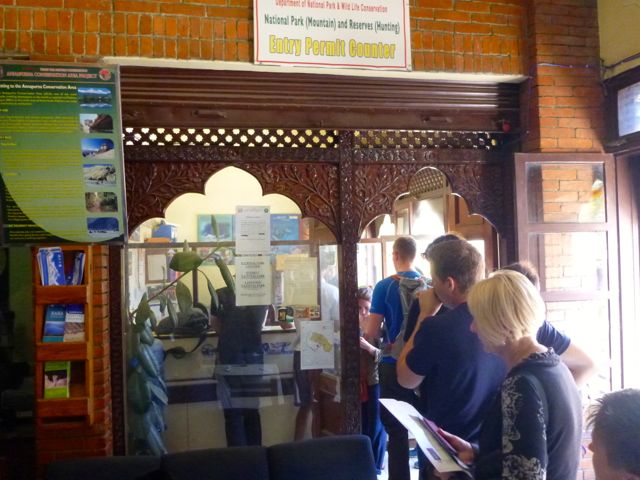
Three times en route we disembarked at checkpoints. The first only looked at our TIMS card. The next two required both TIMS and our Langtang National Park permit.

P1310751

I had paid for both in Kathmandu, but some on the bus were missing one or both. Happily, you could purchase them at the checkpoints.

We disembarked Syabrubesi 1300m at 3:30pm.

I had late “breakfast” and enjoyed free wifi before starting up the trail. Very late in the afternoon.

Everyone else spent the night in town. I was rushed to get high.

P1310754

P1310756

P1310759

P1310760

P1310764

P1310769

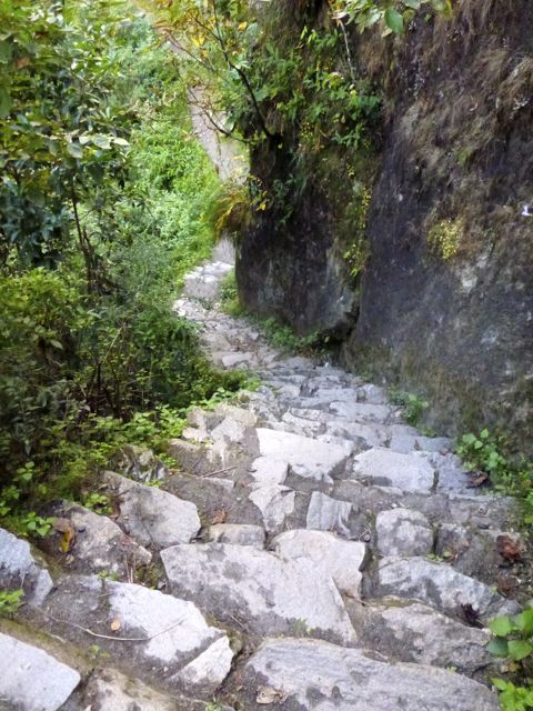
I walked about 90 minutes up to Pairo (Landslide or Hotsprings).

P1310778

___
Marketing 101:

Good marketing is calling your lodge Hotsprings. Bad marketing is calling your lodge Landslide.
🙂
___

Great lodge. I had fun my first night chatting with a Brit and his Guide who were boozing, celebrating the end of his adventure. Sadly, the hotsprings were not available as a bridge had washed out. It was supposed to be repaired by the time I came back down trail in a week.

see all my high res photos from this day

___

Heading up trail towards Pairo is by far the most popular start to the Langtang trek. More scenic, but longer and tougher, is starting towards Khangjim 2235m instead. The mantra is “slowly, slowly” on the way up. Walking via Khangjim is slower, better for acclimatization for altitude. I should have gone that route.

day 0 | day 1 | day 2 | day 3 | day 4 | day 5 | day 6 | day 7 | day 8 | info | … Gosainkund

Langtang Trek – day 0

Trip report by site editor Rick McCharles

World → AsiaNepal → Langtang

P1320042

Why We Like This Hike

  • mighty peaks of Langtang (7234m) and Ganesh (7446m) as well as a sprawl of endless 6000m+ summits
  • sacred lakes of Gosainkund in the nearby Helambu region
  • wonderful photographic opportunities
  • it’s fun to leave the main trails, take challenging side trips
  • very little gear is needed (though I took a ton)
  • walk with no tent, stove or food (though I carried all of those)
  • stay in simple lodges, eat in simple restaurants.
  • safe and easy to hike solo
  • no need to speak Nepali, only English

Langtang National Park established 1970 Langtang Region. It was, in fact, the 1st National Park in Nepal.

Langtang is the closest trekking region to Kathmandu. Yet over 5 trips to Nepal, I’d left it to last, opting for the other major areas in previous trips: Everest (2009), Annapurna and Manaslu (2013).

Langtang is considered the easiest of the four. We learned, however, that Langtang is NOT easy.

Langtang is lower elevation … unless you opt to do side trip trekking peaks or base camp hikes, that is. Many do. I did.

The 2014 Nepal snowstorm disaster had just happened, killing at least 43 people including at least 21 trekkers. That was in Annapurna and Dhaulagiri. Alarmist news headlines had parents of hikers worried, but on the ground in Kathmandu it was business as usual. Some people did divert from Annapurna to Everest or Langtang.

It was easy to find the trekking permit office in Kathmandu. And to buy my own TIMS card. And Langtang National Park permit.

P1310592 P1310594

As with many Nepal hiking adventures, the biggest challenge (and risk) for the independent trekker is getting to the trailhead. Bus rides in Nepal can be more dangerous than high alpine passes. 😦

For Langtang, almost everyone needs to get from Kathmandu to Syabrubesi 1500m.

It’s simple to organize transport back from the small town, but in Kathmandu it’s not so easy to find transport up into the mountains. My guidebook (by Bob and Siân) was useless.

The boss at Kathmandu Environmental Education Project (KEEP) told me there were 4 main modes of transport:

• Jeep
• Super Express mini-bus $5
• Express mini-bus
• local bus

They all left from the same area of town – Macha Pokhari.

In Thamel, travel agents seemed disinterested in me paying them a commission for arranging a ticket for the following day. Instead, I ate my free hotel breakfast at 7:30am, then took a taxi to Macha Pokhari arriving about 8:20am.

I’d happily pay for a Jeep, if I could get a seat. Super Express was my second choice.

Unfortunately I missed all modes of transport heading north for the day. 😦 The trip takes 6-11 hours, depending, and it’s dark in November by about 5:30pm.

Feeling stupid, I walked back to Thamel (via the Monkey Temple) as punishment for not showing up by 6:30am, to be sure of getting a seat.

This is one of the challenges for an independent hiker in Nepal. If I had a guide, he would have arranged my travel. (Most likely on the local bus, as it’s a few dollars cheaper.)

I was delayed a day. 😦

day 0 | day 1 | day 2 | day 3 | day 4 | day 5 | day 6 | day 7 | day 8 | info | … Gosainkund

Hiker’s Guide to Cyprus

guest post by Hollie Mantle

Cyprus doesn’t necessarily strike you as the number one hiking destination, but in fact the dramatic scenery, mountains and coastal paths make it a fantastic place for walkers of any experience level. Here are three tried and tested walks you might want to try (though you can definitely find others, and even accidentally stumble on to others whilst finding these!)

photo by Bald Hiker
photo by Bald Hiker

Aphrodite Trail

Start Point: Baths of Aphrodite

Distance: 8 kilometres. At the utmost peak you’ll reach 370m.

Best for: This hike is for those who are serious about walking; first timers might want to skip this one and head straight into the Baths of Aphrodite or grab some lunch on the terrace. The walk involves some steep uphill climbs, so pack proper walking gear (and don’t even whisper the word ‘flip flops’). Keen photographers will also enjoy this walk as you’ll get some cracking shots over the Akamas Peninsula; there’s definitely satisfaction to come at the end of the struggle with this one.

Time it takes: 3-4 hours depending on how leisurely you’re planning to amble.

Why it’s great: This is renowned as one of the most beautiful trails in the whole of Cyprus.

How to get here: If travelling from Paphos, take bus 645 from Karavella bus station to Polis. This journey takes roughly 50 minutes and leaves on the hour from 8am. From there, change to the 622 to the Baths of Aphrodite. This takes about 30 minutes and again leaves on the hour.

Where to stay: There are loads of stunning hotels – you can check the reviews on TripAdvisor to see which suits!
___

Agros Kato Mylos Nature Trail

Start point: Near the Rodon hotel.

Distance: 6 kilometers.

Best for: Seeing vineyards, orchards, and the rose bushes which the small town is famed for – the annual rose festival takes place in May when thousands of roses are picked to make rosewater. There are also feasts, dances, and ceremonies that attract a lot of tourists during this month. This walk is average in terms of difficulty, but is easier than the other two listed, if a little dangerous and slippy at points.

Time it takes: 2 hours.

Why it’s great: Agros is really tiny, with a population of only around 800. This means you can really escape the tourist clap-trap here and get back to nature without touts trying to sell you knock off souvenirs or overpriced restaurants. The locals are warm and welcoming, and you’ll get a taste of what life is like in rural Cyprus whilst gobbling down some of the most glorious food on the whole of the island. The locals have a lot of traditional syrupy sweets which are also worth a try.

How to get here: 90 minutes from Pathos International Airport – so if you’re not adverse to the idea, rent your own car and drive (there’s not so much in the way of public transport in this area)

Where to stay: Given the size of the place, hotels are few and far between, but you can check out reviews for a few of them here. Rodon is popular with people around Greece who like to get out of the city at the weekends, or for people in the area looking for a great dining experience. The name means ‘rose’ and has added considerably to the economy of the region!
___

Troodos Trails: Artemis

Starting point: The start is at a small brown hut on the road leading up to Chionistra (Mount Olympus). Take the narrow track immediately to the left of the brown hut (do not follow the signs which suggest it’s the other way – it’s all lies at that point!)

Distance: 7 km. 1850m altitude.

Best for: Great views! This walk is recommended for experienced walkers who are prepared for the rough terrain, or just holidaymakers who fancy a scenic walk and aren’t scared of putting in a little legwork and being careful on the rocks. (Or those with super dodging skills if you decide to go in winter – you might get knocked off the path by passing skiers).

Time it takes: 2-3 hours.

Why it’s great: Goes around Mount Olympus in the Troodos Mountains. This site is often home to weddings, wine lovers coming for tasting sessions and skiers during the winter. You can get some spectacular long distance views when the weather is good(on a really clear day in the winter you can sometimes see out to the coast at Limassol). There are also lots of ruins set into the mountain sides. Best to head out later in the season rather than summer, when the flowers will be in full bloom. (Although don’t go too late, because in winter it won’t be a trail so much as a ski slope).

How to get here: This site is really useful if you’re planning on travelling around by bus. Or rent a car – it’s a 1 hour 15 drive from Pathos International Airport.

Where to stay: You can find a write up of family run hotels and more rural retreats here. Olympus Cyprus

new Nepal trekking regulations?

I’ve just arrived Kathmandu.

Officials in Nepal say they plan to introduce tougher controls of the trekking industry, a week after a devastating Himalayan storm.

In future, all trekkers will be required to register before setting out on the Annapurna circuit, they told reporters.

Only properly trained and accredited guides will be able to lead treks. …

BBC – Nepal plans to tighten rules on trekkers and guides

This news report, like many I’ve seen in the mainstream media, are not accurate. Click over to wikipedia for ongoing updates and an a more objective overview of the tragedy.

Not clear in the media is that all Annapurna trekkers already must register to get their ACAP permit. All Guides are trained and certified.

My best guess is that independent trekking will still be allowed in 2015. The director general of the Department of Tourism, Tulasi Gautam, has to say something.

This for example:

… In future, all trekkers must register at check posts when they enter and leave the popular trail (Annapurna), officials said. …

On Annapurna, Everest, Manaslu, etc., you already check in with multiple checkpoints. It’s been that way for decades.

related – Picturing the Blizzard That Caused Nepal’s Worst-Ever Mountaineering Disaster:

blizzardI’ll be careful. Don’t worry.

climbing Fanispan in a day

trip report by site editor Rick McCharles

“the Roof of Indochina”

AT A GLANCE

  • map Fansipan3,143 meters (10,312ft), Fanispan is the highest mountain in Indochina
  • northwest region of Vietnam, near the Chinese border
  • 9km southwest of Sapa (Sa Pa), a gorgeous hill station developed by the French
  • pine forests, bamboo thickets and jungle

Oct 20, 2014

P1310402

Breakfast at the fantastic Unique Hotel starts 7am. Since I was leaving at 5am, the cook awoke early and put together a takeaway breakfast for me. 🙂

I arrived at Sapa O’Chau travel agency at 5:10am for the 5:30 rendezvous. Guide and driver were there already, so we departed instantly.

By 5:30am we were marching briskly up the trail. In the dark.

“Silver”, my guide, spotted a wounded bird near the Ranger Station. Knowing that some dog would dispatch him in the morning, he carried the bird along with us until finding a safer place in the forest.

P1310342

We started early because I opted to climb Fanispan in one day US$95, rather than the normal US$180 2-day itinerary.

P1310348

Silver quickly decided I was strong enough to make it. I hoped he was right.

The trek is wet. And muddy. At the bottom you are often walking in creek beds and runoff streams.

P1310355

Happily for me, it had been very dry of late. My feet did not get wet over the entire day!

The best sections are ridge walks with misty valley vistas far below.

P1310436

P1310442

Surprisingly, long sections of the ridge are protected with concrete railings. They are well built and seem to be enduring the climate very well.

P1310435

I asked my guide about poisonous snakes. He laughed, saying the snakes this high are very wary. People don’t see them. But in his village, Kat Kat, there are many, many.

P1310358

Just around the next corner we came across that one, bludgeoned to death. Silver was sorry to tell me that his people eat large snakes and kill small ones.

You’ll only see goats and buffalo on this trek. For anything more exotic check the restaurants of Sapa. Some Asians are happiest eating the most endangered species. 😦

porcupine Sapa

Almost everyone climbs Fanispan with a guide. But I did talk to one guy from Hanoi who did it alone. In a day. Much faster than me. Parts of the trail are marked with collapsed signposts and fading red markers.

P1310362

It would be easier to follow the trash, however. Only western tourists and guides pack out what they pack in. I’ve always found indigenous peoples to be the very worst litterbugs.

This day we were first to arrive at Camp 1 – 1,500m (4,920 ft). You can buy snacks and drinks here. The guard dog was chained.

P1310366

P1310368

Up and up. Into the clouds. Fanispan’s summit is usually clouded over.

P1310375

P1310377

Multiday hikers normally stay at Camp 2 – 2,800m (9,190 ft). Either in fairly dirty buildings or in much cleaner tents carried by porters.

P1310390

We had a meal here on the way up. And on the way down.

P1310391

P1310430

Though I set out my alcohol gel, my guide didn’t use it. Other cooks I saw were equally unsanitary.

Camp 2 is atrociously trashed. The main reason I chose to do a one day climb was to avoid staying here. 😦

If you feel I’m exaggerating, click over to a photo of the toilet.

This is a tough trek. There are dozens of sections where you really need to scramble. Many inexperienced hikers must turn back.

Here’s one essential handhold.

P1310420

Though in a hurry, we got stopped high up for 30min because a work crew was blasting rock.

P1310416

P1310421

Turns out a cable car is being built. It will open September 2015 or sooner. There must have been 200 workers living atop this high mountain.

P1310410

P1310411

P1310412

I took perverse pleasure in seeing this mess, but I’m not going to recommend Fanispan to others. The cable car will further degrade the hiking experience.

We did finally stand on the summit, the highest spot in Indochina.

P1310405

I assumed it would be quick down. But we didn’t get back to the Hoàng Liên National Park Ranger Station until 5pm.

That was 11.5hrs up and down. Including 2 half hour stops for food.

I was awarded a certificate and medal. 🙂

P1310458

I could barely walk that evening. But seemed to be completely recovered next morning. 🙂

See my high resolution photos from this adventure on flickr.

See our old information page – Fansipan, Vietnam – not recommended


Simien Traverse, Ethiopia

I’m hoping to do the famed Simien Traverse in early December 2014. I’ll be in country Dec 1-14th. It’s the best hike in Ethiopia, one of the best in the world.

Simien

Click PLAY or watch a some highlights from a 2014 trek on YouTube. It looks spectacular. Scenery and wildlife. Especially the Gelada Baboons.

I’m using the most recent Lonely Planet Ethiopia to start my research.

I plan to fly Addis Ababa to Gondor, buying my ticket when I get to Ethiopia. Spend at least one night in Gondor, acclimatizing, before traveling about 2hrs north to Debark.

map2

The Simien Park Hotel in Debark is reputed to have hot water showers. One night there while I organize my adventure at the National Park Office.

I’m hoping to either join a group headed up or to hire the minimum for a solo trek. That’s one ‘Scout’ (armed park ranger) and one English speaking guide.

No mules. No cook.

The most popular route is 4-5 days to Geech or Chenek and back. I’ll not summit Ras Dashen, the highest peak in Ethiopia.

Leave a comment if you’ve done this trek.

deaths on the Annapurna Circuit

Rescuers in Nepal are trying to reach more than 20 trekkers trapped below a high Himalayan pass by heavy snowfalls and avalanches as the death toll from the unfolding tragedy was reported to be as high as 32.

High winds and blizzards hit much of central Nepal this week as the tail end of a cyclone travelling west across northern India reached the Himalayan mountain chain. The head of the Trekking Agencies Association Nepal said there had never been a disaster like it. …

Local officials said 24 bodies had been found on the Annapurna circuit, which circles the Annapurna mountain and attracts thousands of walkers every year.

Guardian

I was there last year. In perfect weather. 😦

Thorong La, 5,416 m (17,769 ft)

There was a similar disaster some years ago. Many killed. Many hikers trapped at the Annapurna Sanctuary.

Fansipan, Vietnam – not recommended

World → Asia → Vietnam → Fansipan

No longer one of the best hikes in the world

Fansipan

  •  Vietnamese: Phan Xi Păng

“the Roof of Indochina”

A cable car will open September 2015 or sooner, degrading the hiking experience. The Sapa area is great, but trek elsewhere in the region. This summit will soon be flooded with suitcase tourists. 😦

Below is our old information page, no longer being updated.

Update (this is an exception 🙂) from patriciaoprea March 2017:

I paid about 60 USD the night before (I’m so last minute) for a tour from Sa Pa
It was 2 days,1 night.

The good thing about this? We arrived at the summit at 7:00 in the morning.
The cable car is built, but NOBODY is there at that hour, because it hasn’t opened yet!

I loved this hike, go for it 🙂


AT A GLANCE

  • map Fansipan3,143 meters (10,312ft), it’s the highest in Indochina
  • Northwest region of Vietnam, near the Chinese border
  • 9km southwest of Sapa (Sa Pa), a gorgeous hill station developed by the French
  • 1-3 days hiking
  • pine forests, bamboo thickets and jungle
  • best months October through April. Some say April and May are best as it’s warmer. And the flowers are in bloom.
  • avoid the wet season from June to September, with heaviest rainfall occurring in July and August
  • record for scaling Fansipan is one hour and thirty-five minutes, in case you want to better that time. 🙂

Panoramic views of the mountain ranges of northwest Vietnam, if you get any views at all. The summit is famously shrouded in cloud.:-(

Why We Like This Hike

  • about 2,024 floral varieties and 327 fauna species (sadly many of the larger animals have been hunted out)
  • no ropes or technical climbing skills are needed
  • plaque at the peak placed February 2007
  • colourful minority ethnic people, especially on market days
  • ridge walk sections were our favourite

P1310436

Considerations

  • malarial mosquitoes can be a danger some months of the year
  • bring warm clothes. Temperatures below freezing are frequent.
  • snow is possible
  • climb is rough, wet, muddy and cold. Some bring rubber boots.
  • gloves with good grips recommended for ladders and rock scramble
  • scramble ladders and tree roots
  • you may be clutching bamboo at points
  • we’ve seen warnings about poisonous snakes, leeches, rodents, perhaps exaggerated
  • dogs are a worry, both in Sapa and on the trail. Even if you don’t carry a trekking pole, you might want to carry a stick
  • Sapa is a tourist trap. Touts are a pest.

Cost

Guided trips are no longer as inexpensive as they once were. Seems the government got stricter with guide requirements.

We paid $95 for a one day, up-and-down for 1 person October 2014.

A two day trek costs $180 for 1 person October 2014. You can negotiate on price with some agencies.

Shop around. The official government tourist information office quoted $120 for the $95 tour. Assume the difference is commission.

Routes

There are a number of options, including a 1 day guided up-and-down.

It’s possible to do independently. But we wouldn’t recommend it unless you are familiar with the route.

click for larger version

There are three routes to the mountain. One is from Tram Ton, the others from the villages of Sin Chai and Cat Cat.

The first route is a more gradual climb because it has been selected for tourists. The trip can be made in a day.

The route from Sin Chai is shorter but more adventurous, requiring climbers to sometimes use ropes or other special facilities for climbing.

The route from Cat Cat is the longest, but mixes some challenging climbs with great scenery. After one day of climbing, there’s a break at 2,200m above sea level. Climbers can have a meal cooked by a Mong porter and camp, followed by a second camp at 2,700m before reaching the peak on the third day.

Most climbers chose a tour from Sa Pa at a cost of about VND1.5 million excluding train fare from Ha Noi, and tours should be booked a month in advance.

Climb Sipan
  • many hikers arrive by overnight train from Hanoi to Lao Cai, then bus from Lao Cai to Sapa. Those tickets sell out during high season, especially during holidays, as Sapa is super popular with Vietnamese.
  • even better, some feel, is the night sleep bus direct from Hanoi
  • we stayed at the Sapa Unique Hotel for about $35 / night. It gets rave reviews.

Trekking Guides

Logistics

We recommend you hire a guide. Let them do the logistics. You simply enjoy the journey.

  • on the most popular route up from the Ranger Station Camp 1 is located at around 1,500m (4,920ft). Simple accommodation and food are offered.
  • at 2,800m (9,190ft) is Camp 2. Sleeping is communal in a very poorly maintained ‘hut’. Might have rodents. Have your agency bring tents, instead. Camp 2 is trashed and unsanitary.

Local Information

  • none aside from hotels and lodges

Best Trekking Guidebooks

  • none that we know of

Best Travel Guidebooks

Best Web Pages

Best Trip Reports

Movies

Click PLAY or watch Leonard Boey’s 2013 trip highlights on YouTube.

Questions? Suggestions? Leave a comment on this page. Our editors will reply.