Best Laidback Hikes, Banff National Park

By Lukas Saville:

The rugged terrain of the Canadian Rockies might seem a little imposing at first glance, but once you do a bit of research and immerse yourself in this breathtaking landscape filled with jagged peaks, crystal clear lakes, and sprawling forests, you’ll find that it is fairly accessible for most outdoor enthusiasts. 

With its charming village and easy access to a wide variety of hiking routes, there is no better place to begin exploring the Rockies than in Banff National Park. Whether you are new to hiking and want to take in the natural beauty of the mountains for the first time, or are a seasoned outdoorsman looking to kick back with your grandkids on a relaxing adventure, there is no doubt that you will be able to find a hiking trail in Banff that will perfectly suit your needs. 

With that in mind, I’ve put together a great little list of the best laidback hikes in Banff National Park that will certainly make for an amazing day outdoors, no matter your age or skill level. Just don’t forget to pick up your Parks Canada Pass before setting out on your adventure!

6 Best Laidback Hikes 

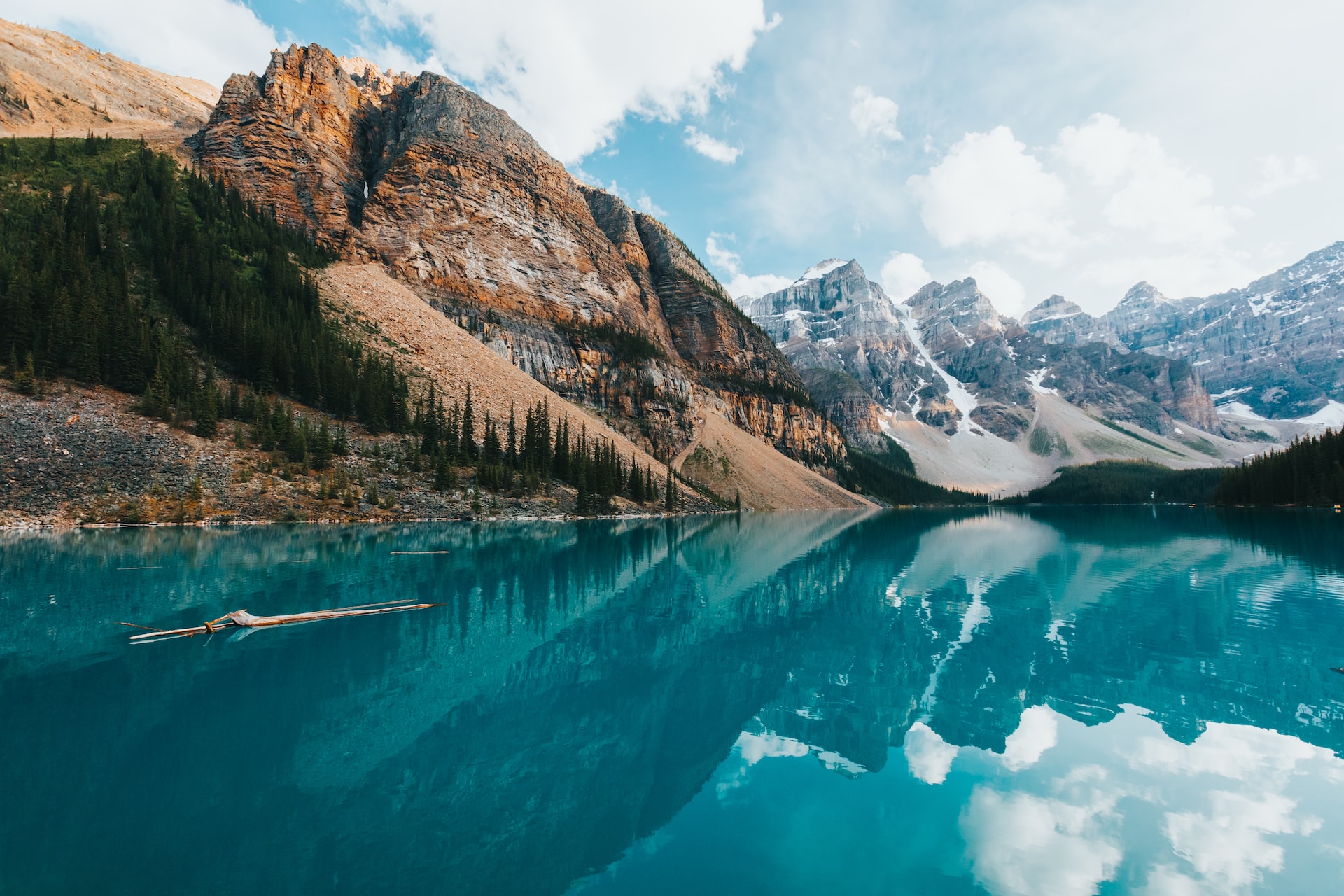
  1. Moraine Lake Hike – Distance: 3.4km | Elevation: 38m | Time: 0.5-1h

This breathtaking hike will expose you to some quintessential Rocky Mountain views for a minimal amount of required effort. Gorgeous mountain peaks and the glittering surface of Moraine Lake make this an absolute must-hike if you are in the area.

Suitable for all ages and skill levels, you will need to time your hike to avoid the crowds, as the large volumes of visitors and limited parking can be a bit frustrating. Even still, this is the perfect hike to take in the beauty of Alberta.

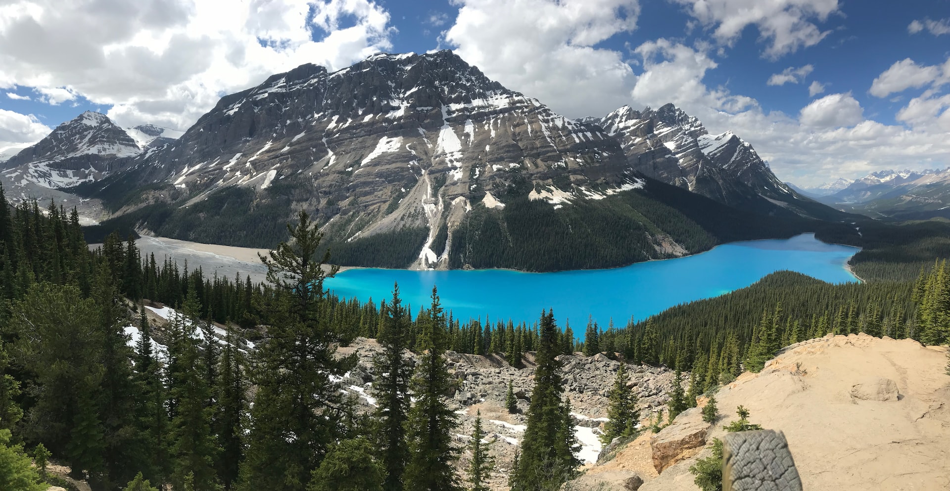
  1. Peyto Lake Viewpoint Hike – Distance: 2.6km | Elevation: 80m | Time: 0.5-1h

Located along Icefields Parkway, the Peyto Lake Viewpoint Hike is a quick and easy adventure that should be on everyone’s list. 

Featuring two scenic viewpoints overlooking the pristine Peyto Lake and surrounding mountains, this is a great bang for your buck excursion that won’t take up too much of your time.

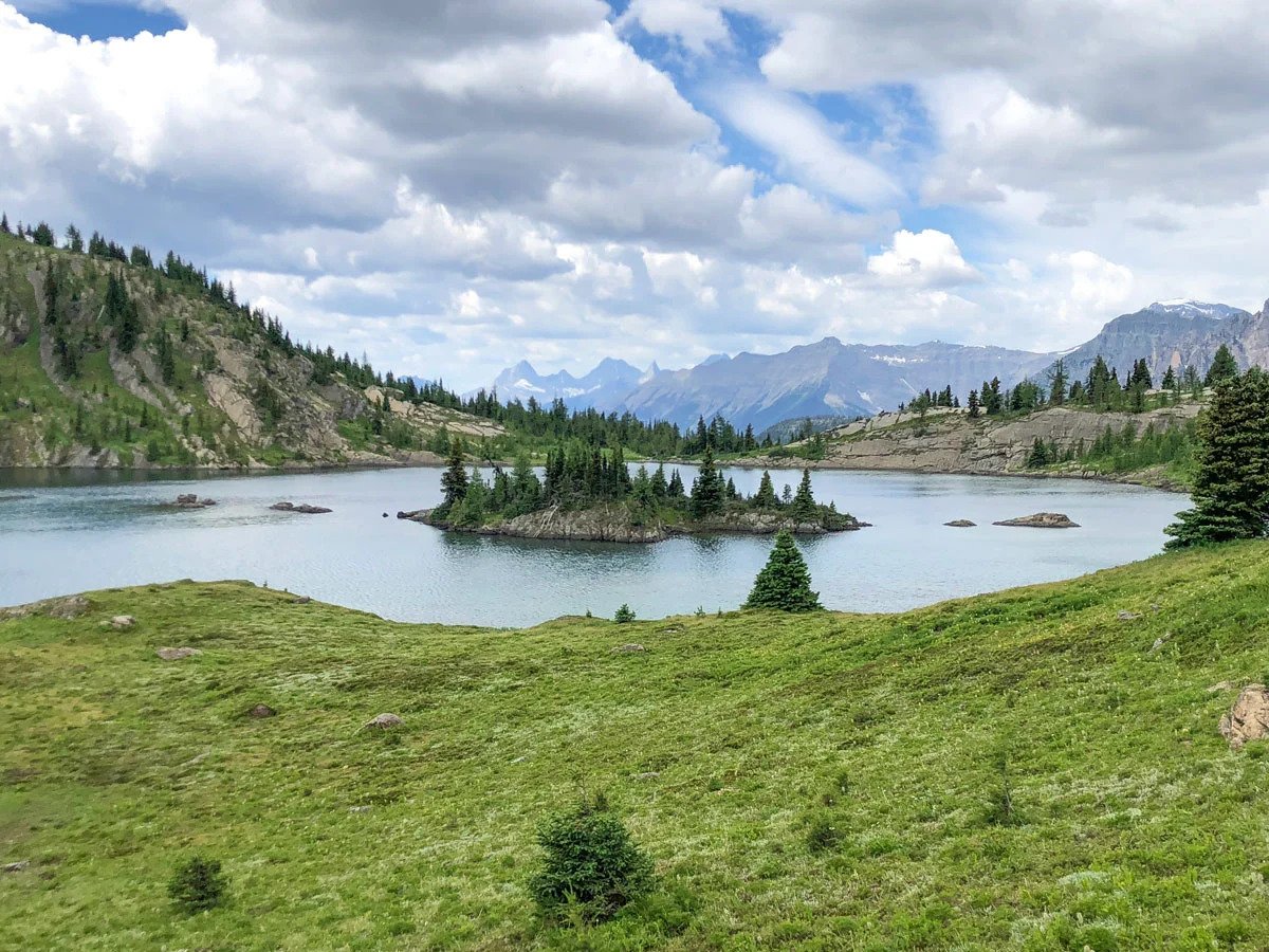
  1. Monarch Viewpoint Hike – Distance: 7.2km | Elevation: 175m | Time: 1.5-3h

Stunning meadow scenery and a fun gondola ride characterize this spectacular family-friendly adventure in Banff. The Standish Viewing Deck, Rock Isle Lake, and of course Monarch Viewpoint are all highlights of this 7.2km hike, making for an action-packed day on the trails.

Although kids will need to be able to ride a chairlift, the views on this hike are simply too good to avoid!

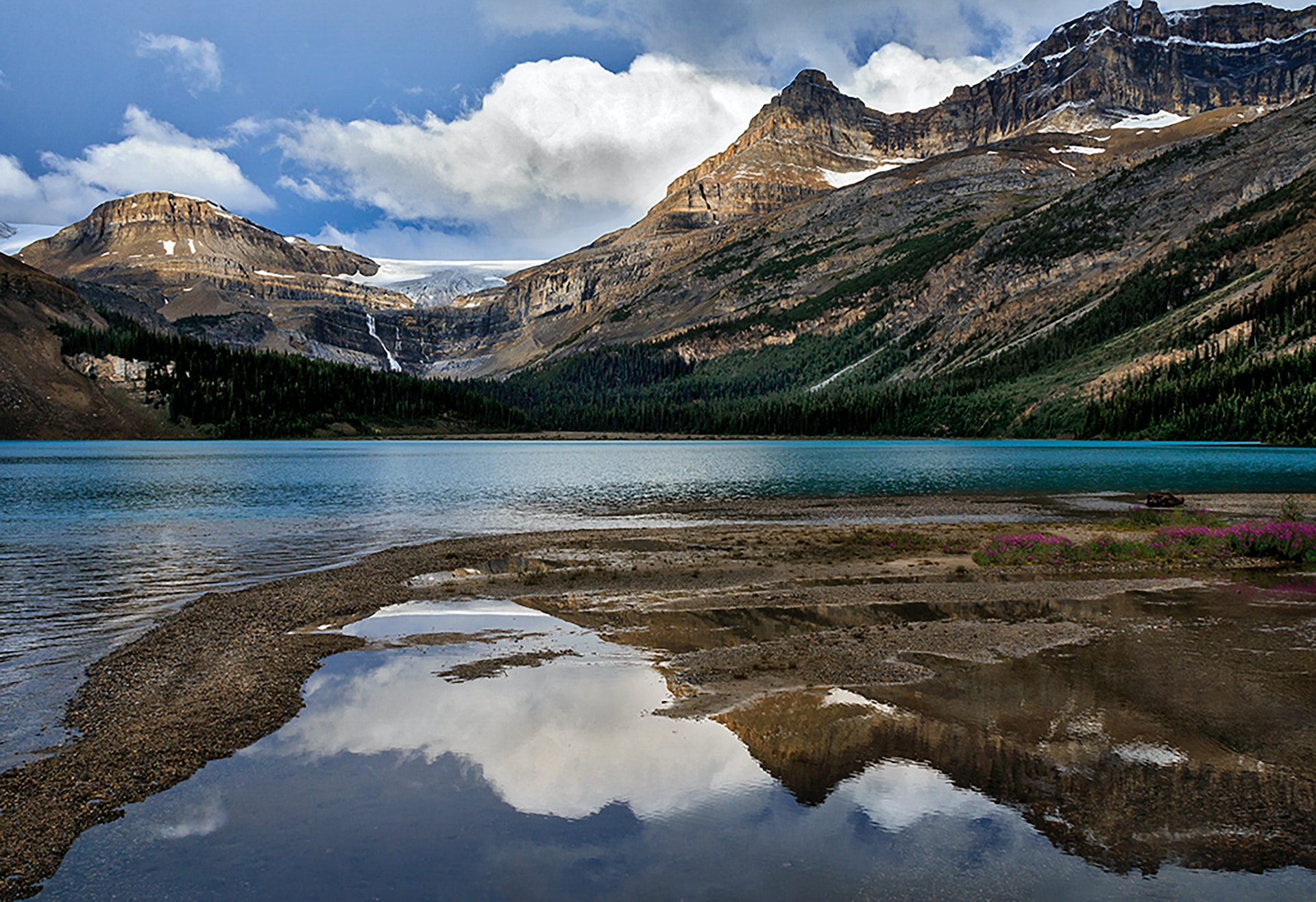
  1. Bow Lake Hike – Distance: 3.4km | Elevation: 2m | Time: 1-1.5h

Another short and scenic hiking route along the Icefields Parkway, the Bow Lake Hike is a great option that the entire family will love. Spend some time strolling by the water’s edge, taking in the breathtaking views of the mountain terrain that encompasses the shimmering waters of Bow Lake.

The trail here is flat, well-maintained, and easy to navigate, making it perfectly suited for young children and the elderly.

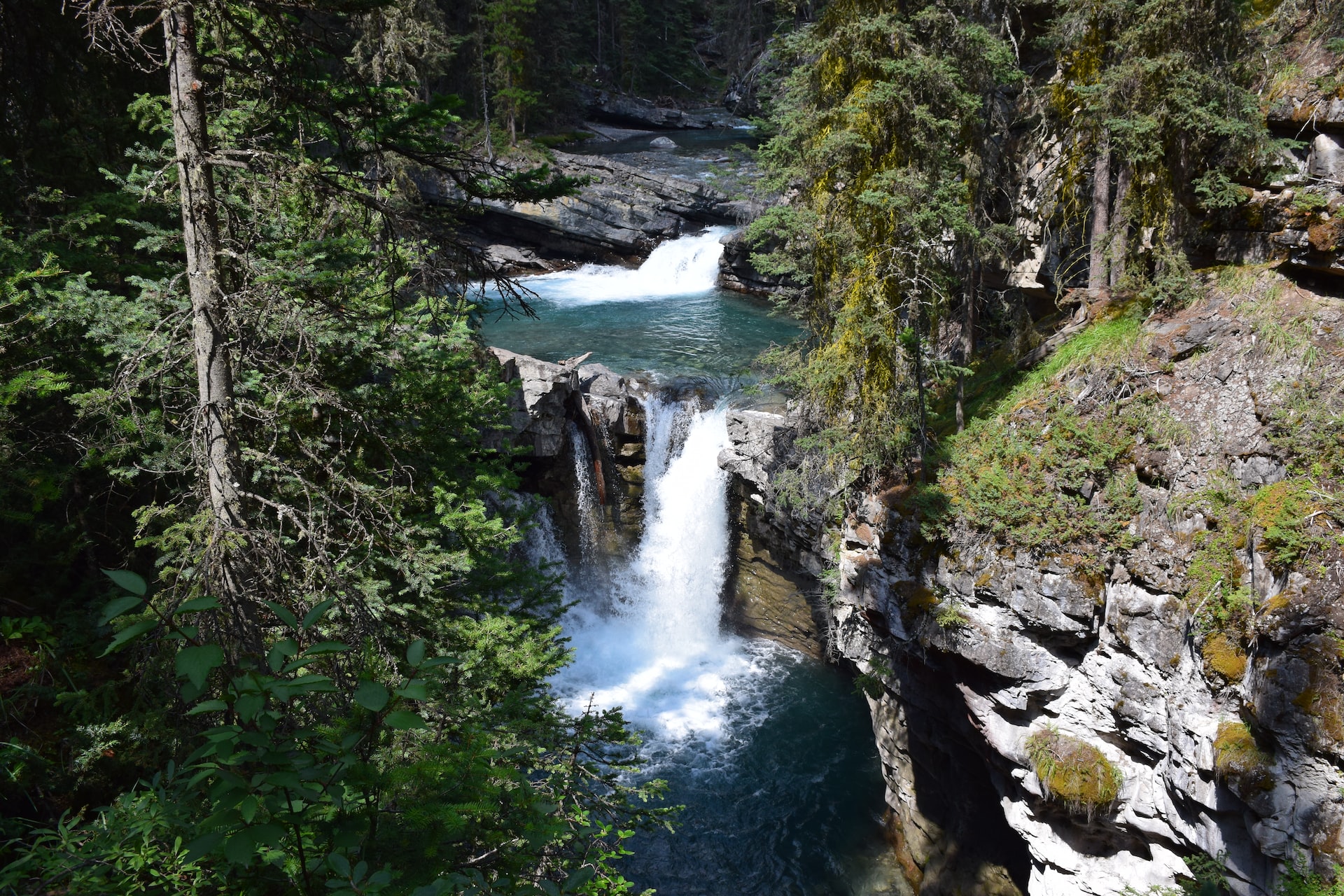
  1. Johnston Canyon Hike – Distance: 6.3km | Elevation: 122m | Time: 2-3h

While busy, the Johnston Canyon Hike is an amazing hiking trail that will lead you through a scenic canyon landscape to a picturesque series of waterfalls. Families and those less-inclined to traverse more rugged terrain can simply stop at the lower falls; however, you can also continue on to the upper falls, which are more impressive.

Due to the popularity of this route in the peak season, you will need to plan on starting your hike before 8AM to avoid the crowds. Additionally, the path can be slippery, so parents should always travel with children, keeping them close through wet areas.

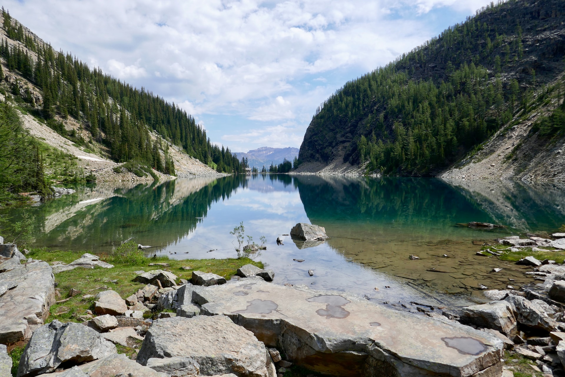
  1. Lake Agnes Tea House Hike – Distance: 7.5km | Elevation: 353m | Time: 2-4h

Last – but certainly not least – is the Lake Agnes Tea House Hike, which is an incredible adventure in Lake Louise. Featuring some of the most splendid views in all of Banff National Park, the Lake Agnes Tea House is the perfect excursion for families, as everyone can get out for some exercise and enjoy some amazing scenery – with a delicious hot chocolate of course!

This route isn’t limited to families, so head up solo or with your friends and hike some of the connecting trails that explore this beautifully scenic landscape.

Other ways to explore the Rockies

After you’ve fully exhausted this list of trails – which shouldn’t take too long – you might be wondering how you can continue unlocking all of the wonders that Banff and the surrounding Rocky Mountains have to offer. 

There are plenty of different solutions that can help you take your outdoor exploration to the next level, starting with booking an unforgettable adventure tour in the Canadian Rockies. For anyone who isn’t a keen planner, booking a tour can be a great way to experience some of the most pristine mountain landscapes in the world, all with the help of experienced professionals who know the area inside and out. 

On the other end of the spectrum, if you are comfortable enough to hit the trails on your own or with a few friends, then a good GPS app – such as the 10Adventures Trail App – is a great option that will enable you to tackle the outdoors at your own pace. Featuring detailed route descriptions, maps, and the ability to track your activity, a trail app can go a long way in helping to keep you safe and on the right path!

No matter what direction you end up choosing, the Rocky Mountains – and Banff National Park in particular – are full of some amazingly scenic and laidback hiking trails, making it the ideal place to begin exploring the natural beauty that Canada has to offer.

FREE Wild Camping in Norway

Report by BestHike editor Rick McCharles

I hiked and bikepacked Norway for many weeks summers of 2018 and 2022.

Norway IS expen$ive. The best way to lower your holiday costs is to sleep FREE in your tent.

A longstanding law called allemannsretten (loosely translated as ‘the right to roam’) allows everyone to wild camp virtually anywhere in open country, for free.

Langøyene island, a 15-minute ferry ride away from Oslo, has grassy glades to pitch up in, right next to the fjord. Sognsvann lake, north of Oslo, is another good spot. …

CAMPING IN NORWAY: THE ULTIMATE GUIDE

That sounds GREAT.

However — it’s a small percentage of Norway that is both flat enough and dry enough to pitch a tent. I was happy I carried a foam sleeping pad as well as my air mattress. I put it UNDER the tent to keep everything a little drier.

If you can’t find a good free spot, it’s easy to locate one of the 1,000 or so paid campsites.

Protection from the wind is another problem. I did hear of wind breaking tent poles. It’s often gusty.

A hiker had recommended this free spot in Sommarøy⁩. Ideal. Wooden tent pad with protection from the ocean wind.

I like having a picnic table to organize gear and sit down for meals.

This was the closest free site I could find near Svolvær⁩. No picnic table.

Here are a few more typical sites.

Last night tenting, I found my MSR Hubba™ NX Easton Syclone tentpole had brokensomehow. It’s the most unreliable part of MSR tents, along with their lightweight zippers.

My favourite campsite was Uttakleiv Beach, Lofoten. But this cost $20 / night. It’s the trailhead for the Veggen and the more popular Mannen climbs.

Hiking out of Longyearbyen, Svalbard, Norway

The Tenacious Trekkers flew up to Longyearbyen and took a guided glacier hike.

Click PLAY or watch it on YouTube.

Svalbard is a Norwegian archipelago in the Arctic Ocean. North of mainland Europe, it is about midway between the northern coast of Norway and the North Pole. …

The largest island is Spitsbergen

The largest settlement is Longyearbyen. …

Approximately 60% of the archipelago is covered with glaciers

The three main industries on Svalbard are coal miningtourism, and research. …

Tourism is focused on the environment and is centered on Longyearbyen. Activities include hiking, kayaking, walks through glacier caves, and snowmobile and dog-sled safari. Cruise ships generate a significant portion of the traffic …

Population of Svalbard is around 3000.

I’d love to get up there one day.

Oregon Coast Trail is NOT REALLY a Trail 😀

Forced off the Pacific Crest Trail due to forest fire, Ryan (Kodak) Brown and his partner Ilse Cinnamon Praet decided on Oregon, instead.

The two cofounded Wilderland Media.

It’s more of a ROUTE, not a continuous trail. More than 150 miles (240 km) of the route is on pavement.

Walked in its entirety, linking each trail/beach section, the distance is approximately 425 miles. …

The northern trailhead is at the base of the south jetty of the Columbia River, approximately 4 miles (6 km) north of the campground of Fort Stevens State Park and about 13 miles (21 km) from the city of Astoria.

The trail runs north-south along the entire Oregon Coast, following the shore as closely as practical.

For many portions of the route, it is beach walking, mostly on sand. In populated areas it often follows the nearest street to the shore.

Many parts of the trail leave the beach and take an inland path, usually where land formations make the shoreline impassable, such as at Cape Kiwanda.  …

Wikipedia

Click PLAY or watch it on YouTube.

400km on the Cordillera Blanca Traverse, Peru

This is a route invented by Cam Honan 2014.

  • 400 km (249 mi)
  • 16-22 days
  • more than 20 mountain passes ranging between 4,347 m and 5,201 m (14,262 ft-17,064 ft)
  • 4 stages for resupply

The jumping off point is Huaraz, Peru, one of our top 10 hiking towns in the world.

If interested in being one of the first to complete this high alpine traverse, check Cam’s post:

A Quick & Dirty Guide to the Cordillera Blanca Traverse

To get an idea of the challenge, watch Austin Lillywhite’s CBT Video from 2017. (10min)

Hiking in Svalbard. … Also, WHERE is Svalbard? 😀

Svalbard is a Norwegian archipelago in the Arctic Ocean. North of mainland Europe, it is about midway between the northern coast of Norway and the North Pole. …

The largest island is Spitsbergen

The largest settlement is Longyearbyen. …

Click PLAY or get a glimpse on YouTube.

#5 day hike – Reinebringen, Lofoten, Norway

One of our top 10 day hikes in the world

Why?

Reopened in 2019 with sherpa-built steps.

Now much safer and easier.

  • Reinebringen is on the island of Moskenesøya , one of the Lofoten islands in Norway, north of the Arctic Circle
  • infamous for wind and rainy weather
  • famed for dramatic scenery,  rugged peaks, open sea vistas past sheltered bays
  • about 448 meters (1470 feet) above sea level
  • over 1500 stone steps
  • about 2 hours up
  • It’s crowded. Over a thousand people a day in high season if the weather is good.
  • permits not required

World → Europe → Norway → Reinebringen, Lofoten

For details click over to our Reinebringen, Lofoten, Norway information page.

I QUIT the Long Crossing of Lofoten Archipelago, Norway

BestHike editor Rick McCharles

Inspired by Cam Honan’s 2018 adventure, I set out for the Long Crossing – a 160 km (99 mi) hiking route through the spectacular heart of the island chain. 

It’s not all that popular yet. In fact, AllTrails doesn’t have it. And it has every trail everywhere.

After one day — 9 hours in perfect weather — I’ve decided to QUIT. That day was too difficult and too dangerous for me carrying a heavy pack.

Olderfjorden pass

It LOOKS easy in the photo. But it’s mostly route finding through marshy terrain. Worst was a risky descent clutching a water pipe and safety ropes. Starting up near the top of the waterfall.

This was the Kleppstad to Svolvær leg.

I’d already visited Lofoten on another trip, doing most of the popular day hikes.

I’ll follow the general path of the Long Crossing. But camp low. And climb high with a day pack. Weather will dictate which established day hikes I choose.

I’ll be following recommendations set out in the Rando-Lofoten guidebook by Souyris & Brede:

Hiking the Lofoten islands

Wish me luck. Things tend to #fail in Arctic Norway — usually due to weather.

Climbing Segla (Sail) Mountain on Senja Island, Norway

Trip report by BestHike editor Rick McCharles

The main reason we make the long trip to Senja Island is to climb high and enjoy otherworldly views.

Click PLAY or see Segla mountain and others on the island on YouTube.

Senja is even further north than famed Lofoten archipelago , but is equally spectacular in places.

The jumping off point is remote Fjordgård, not easy to reach by bicycle.

I camped for free along the ocean. A very windy night.

The east side of Segla starts rising gently, whereas the steep cliffs on the west side drop directly into the fjord. The EASY route is still challenging near the top. You’ll be using your hands.

BUT first it’s recommended to do the Hesten hike, rewarding you with the most impressive looks at the peak. 3.7 km return. Hesten is 556m.

Next climb Segla itself, if you have the energy.

Around 4km return. Perhaps 2 hours up, 1 hour down — IF you move steadily. Weather is the main factor. It can switch from sun to rain storm in just a few minutes.

Click PLAY or watch my video highlights MUSIC video 😀 on YouTube.

related – detailed trip report by Worldering Around – Segla, Senja Island – Best View Of The Iconic Mountain From Hesten Hike

June to September are the best months.

Island of the Blue Dolphins

I’d recently enjoyed reading the young-adult wilderness survival novel series written by American writer Gary Paulsen. It starts with The Hatchet (1986).

Island of the Blue Dolphins (1960) is some what similar.

… the story of a 12-year-old island girl named Karana, who is stranded alone for years on an island off the California coast.

It is based on the true story of Juana Maria, a Nicoleño Native American left alone for 18 years on San Nicolas Island during the 19th century. …

… the subject of much literary and pedagogical scholarship related to survival, feminism, the resilience of Indigenous peoples, and beyond. …

Both books won the Newbery Medal for distinguished contributions to American literature for children.

It was made into a film in 1960.

Click PLAY or watch it on YouTube.