Choquequirao to Machu Picchu guided

The best way to get to Machu Picchu is via CHOQUEQUIRAO.

choquequirao-cover

If you want to be guided, here’s one recommended option.

Choquequirao trek to Machu Picchu Trek Private Service, 8 Days/7 Nights Program

Prices are per person : 2 people US$840, 3 people US$790, 4-5 people US$740, 6-8 people US$620, 9-11 people US$590, 12-16 people US$550.

details on Mythical Trails Peru

You can do that independently, of course.

And NOT CHEAT by taking the bus up from Aguas Calientes. Instead you climb in the dark, be waiting for the Gates to open. Then rush up to take photos before the hordes arrive.

Insect repellant essential at some times of the year.

How Much Does Your Gear Cost Per Use?

Good question.

BRENDAN LEONARD SEMI RAD:

… How many times are you really going to use that $3,500 bike? The $600 worth of cams. The $800 skis? No, wait, the $850 powder skis. The really fat ones.

The fact is, if you buy a $3,500 mountain bike and ride it 20 times before you talk yourself into buying a new one, you paid $175 per ride. (not counting gas, new parts, tune-ups, replacement tires, chain lube, and all that stuff).

Craigslist is full of ads selling used bikes that have only been ridden “a handful of times.” …

bike

Adventure Journal

Wales Coast Path

Wales Coast Path mapThe Wales Coast Path … is a long-distance footpath which follows the whole of the coastline of Wales. It opened on 5 May 2012, and offers a 870 miles (1,400 km) walking route from Chepstow, in the south, to Queensferry, in the north.

Wales is the first country in the world to provide a dedicated footpath along its entire coastline. The Path runs through 11 National Nature Reserves and many more local Wildlife Trust and RSPB reserves. …

The 870 miles (1,400 km) of the Wales Coast Path links with the Offa’s Dyke Path National Trail, which loosely follows the border with England, to create a 1,030 miles (1,660 km) continuous walking route around the whole of Wales, although skirting past Flintshire and Wrexham. …

Click PLAY or watch some highlights on YouTube.

Controversy

The Open Spaces Society has criticised some landowners who do not allow the path onto their coastal land. This means 170 miles (270 km) – more than 20% of the route – will be on roads, sometimes out of sight of the sea.

official website

Ciudad Perdida (Lost City) trek

Daniel has a blog all about his year spent in the town of Soledad, Barranquilla, Colombia.

One Adventure took him on a 5-day guided trek to one of the best walks in the world.

Ciudad Perdida (The Lost City) is like the Machu Picchu of Colombia: located deep in the Sierra Nevada it is an old city built by indigenous people where their Shaymans (religious leaders) lived with their wives and families. …

… Some of us bitched about the ones marching on ahead to the front, others bitched about those coming up too slowly behind- and everyone bitched about bloody Mosquitos. …

… The terrain ranged from the clay sandy trails, to riverside walks and treks into deep jungle. Colourful butterflies seemed to constantly encircle us, we spotted a (dead) snake, and lots of tropical birds.

After night 2 the novelty of sleeping in a hammock had disappeared, and the reality of an uncomfortable nights sleep in the cold was hard to deal with. The food was great- our chef Yorman made great meals and often surprised us with treats of chocolate bars and lollipops. Everyone’s dietary needs were taken into account …

read more – CIUDAD PERDIDA / THE LOST CITY

They made it.

Lost City

related – our Lost City information page

hiking the Keystone XL pipeline

KEN ILGUNAS:

I wanted to learn everything about the environmental battle. I saw a country marked by apathy, and flickers of hope.

I’d felt strangely drawn to the Keystone XL.

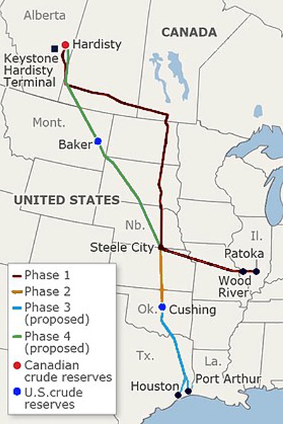
In the fall of 2011, when I fantasized about walking the length of the 1,700-mile proposed pipeline — that, if approved, will carry oil from the Tar Sands of Alberta to the Gulf Coast of Texas — I was a lowly dishwasher at an oilman’s camp in Deadhorse, Alaska.

At the time, I was broke, just out of grad school, and demoralized with my situation. I had a miserable job that didn’t require a high school diploma, let alone the liberal arts degree that had nearly bankrupted me, and I was living in quite possibly the coldest, darkest, dreariest place on earth. I was an adventurer at heart, burdened with the duties of making a living.

I can say, from experience, that when you find yourself washing spoon after spoon, in the middle of the night, in a silent kitchen, at a working camp 300 miles north of the Arctic Circle, you will begin to question the direction of your life. But I can say this also: The soul must first be caged before it can be freed. And when Liam, the cook I worked with, suggested we go on an adventure the next summer and hike the XL, I knew his idea was both crazy and brilliant. I looked at him and said, with what must have been an almost frightening excitement, “We must!” …

read more on Salon – My 1,700-mile hike across the XL Pipeline

XL

You might ask: WHY would they transport dirty oil so far?

… The Port Arthur refinery operates as a Foreign Trade Zone (FTZ), which traditionally gives tax benefits to companies that use imported components to manufacture items within the United States. Usually refineries importing oil tax-free will still pay taxes when selling the refined products into the U.S. market. By both importing into and exporting from Port Arthur the company will avoid paying tax on the product sales.

A pretty sweet deal for Valero Energy Corporation (VLO).

tywkiwdbi

I’ll be very surprised if President Obama does not approve the Pipeline.

But remove that corporate tax giveaway … ??

Death Valley timelapse

Adventure Blog:

… some amazing footage from Death Valley, featuring the expected scenic landscapes, interesting light play and changing shadows. But about a minute and ten seconds into the short film the images start to change dramatically, giving us nighttime shots of those same landscapes while billions of stars dance by overhead. The sense of scale that these images generate is nothing short of awe inspiring and makes you realize just how tiny our little rock truly is.

Click PLAY or watch it on Vimeo.

Yosemite Park timelapse

This amazing video – which captures Yosemite National Park’s 1,200 square miles (about 3,000 square kilometers) of beautiful scenery – first came to light about a year ago via Vimeo. Today (January 17, 2013), Sheldon Neill and Colin Delehanty’s Yosemite HD project has been viewed over 3 million times!

The project totaled 19 days of shooting over the course of three-and-a-half months. It truly is breathtaking. Make sure to stay on the lookout for the meteor shower that happens about halfway through the video.

EarthSky

Click PLAY or watch it on Vimeo.

(via DSD Stones on Facebook)

rest in peace Mark and Rob

Lifelong friends, Rob and Mark Glaser, were killed in an avalanche on Saturday, January 15, 2011 in the area of Burstall Pass, Peter Lougheed Provincial Park, Kananaskis Country, Alberta.

The families of Mark and Rob Glaser are in deep shock at the news of their tragic passing. Both were loving husbands and fathers and will be greatly missed by their families and legions of friends. Both were seasoned back country hikers and skiers who shared a deep passion for the outdoors.

Mark lived in Calgary and was in the oil and gas industry for over 25 years including senior management positions in recent years. Rob lived in Bragg Creek and was a captain in the Calgary Fire Department.

Mark Glaser

Rob was a firefighter, expert in all things backcountry. They had left their avalanche beacons in the car making family speculate that this ski was intended to be simply a short warm-up.

Saskatchewan Glacier

Over 30 years (1978–2007), avalanches have been responsible for 329 deaths in Canada, with a recent rate of 14 deaths per year. …

Avalanche accounts for over 90% of outdoor recreation deaths, most of those in Alberta or B.C.

Be careful out there.

Moonrise over Manaslu

2012 World Open of Photography Finalists

Moonrise over Manaslu – 45-minute exposure of Manaslu, the Earth’s 8th highest peak, in Nepal, the rotation of the Earth turning starlight into arcs. The onset of moonrise at the end of the exposure illuminates the mountain from the southeast.

Moonrise

click through to see a larger, high resolution version.