When Swiss photographer Gus Petro took a trip to the United States last year, he was struck by the juxtaposition of “emptiness and density.” …

See more like that – This Is What It Would Look Like If You Dropped Manhattan Into the Grand Canyon

Best hikes, treks, tramps in the world.
When Swiss photographer Gus Petro took a trip to the United States last year, he was struck by the juxtaposition of “emptiness and density.” …
See more like that – This Is What It Would Look Like If You Dropped Manhattan Into the Grand Canyon
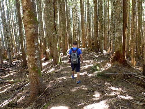
trip report by site editor Rick McCharles
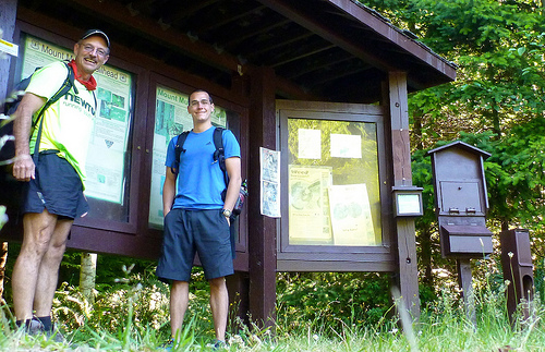
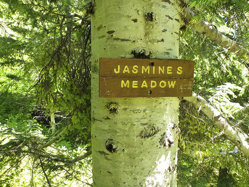
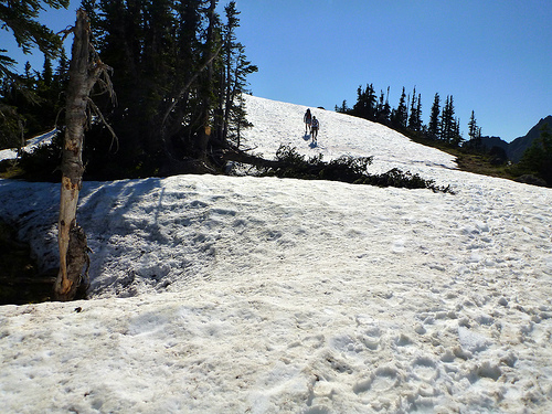
In Day Hiking Olympic Peninsula (2007) by Romano, one adventure caught my eye:
Mount Muller
13mi loop
3200ft elevation gain

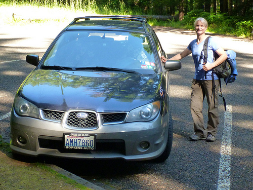
En route to the (easy to find) trailhead we stopped at the excellent Olympic Bagel in Port Angeles.

13 miles … how tough could it be?
… a low-elevation peak located in the northern region of the Olympic Mountains. … Clallam County …
Mount Muller is, however, the county’s point of greatest prominence (also known as the COGPP) and the county’s only peak with over 2000′ of prominence. …
… If the Mount Muller summit is the only goal, it can be reached in 5.3 miles from the west end of the trail system, or it can be reached in 7.5 miles from the east end of the trail system.
Many trail users opt to hike the entire 12.8-mile loop. The mountain is accessible year-round, and the Mount Muller Trail is open to non-motorized use only (i.e. hikers, bicyclists, equestrians, snowshoers).
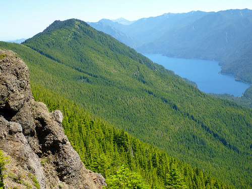
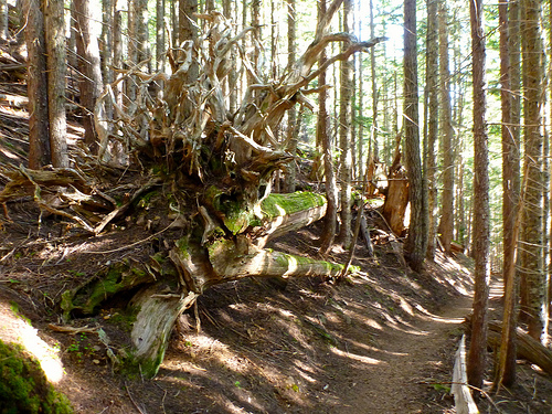
… The ridgetop of the peak is primarily comprised of thick evergreen forests on its west side and rocky outcrops interspersed with forests on its east side …
… views from the mountaintop can be spectacular. Mount Olympus, Lake Crescent, the Strait of Juan de Fuca, Sol Duc Valley, among other notable areas …
A recreational use pass is required for each vehicle parking at/near the Mount Muller Trailhead.
This hike was a labour of love for Forest Service employee Molly Erickson. She and a crew of friends designed and built the trail, naming many of the landmarks after themselves. 🙂
The wildflowers are GREAT. I was surprised to see beargrass this far west.
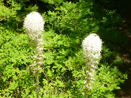
Turns out it’s …
… found mostly in western North America from British Columbia south to California and east to Wyoming, in subalpine meadows and coastal mountains, and also on low ground in the California coastal fog belt. It is common on the Olympic Peninsula and in the Cascades, northern Sierra Nevada and Rockies. …
After the loop, James and I enjoyed a soak in nearby Sol Duc Hot Springs.
related – 6min horseback trip VIDEO
trip report by site editor Rick McCharles
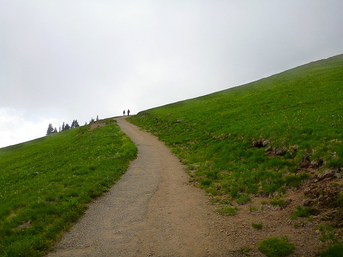
The incredibly GREAT July weather continues. James and I headed directly up the Deer Park road in Olympic National Park.
We’d heard automobile horror stories … but with good weather in July, most any vehicle could climb the 5400ft from sea level to treeline.

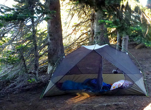
The excellent and unique tenting campground was full, not surprisingly.
Rangers had no wood — budget cuts I assume — but many were able to enjoy a campfire.

The 7.45mi Deer Park Trail to Obstruction was still … obstructed. Ice axes were recommended. So — instead — James and I took day hikes in every direction instead.

And it’s lovely in every direction.
We did the obligatory 0.5mi Rainshadow Trail to the top of Blue Mountain. Touristy. But the fantastic vistas made it all worth while.
From there we dashed out on seldom used trail onto two obvious adjacent ridges.

Views don’t get any better than Deer Park …

… unless you savour them from a HAMMOCK.
James Parent recommends you book a hiking holiday to Olympic National Park. 🙂

No water is available at Deer Park. Toilets are excellent. No parking “pass” is needed. You can pay on arrival for campsites, first come – first served.
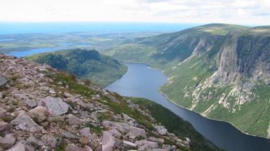
The UNESCO world heritage committee says a monitoring mission should be sent to Gros Morne National Park to assess fracking risks.
… it’s seriously concerned about plans for potential oil exploration near the site. …
CTV – Fracking risks in Gros Morne should be assessed, UNESCO says
State of Canada’s Parks:
Among the good news: a huge new park in Québec which is now eastern North America’s largest protected area and Canada’s largest provincial park!
The bad news? We’ve identified numerous emerging threats to some of our most iconic parks. The threat of oil fracking metres from Gros Morne National Park heads the list, along with ongoing concerns about federal budget cuts and inappropriate commercial developments in our national parks. Also, some provincial and territorial governments are backtracking on promises to create new parks and protected areas. …
read more from CPAWS – One step forward, two steps back for Canada’s parks: CPAWS’ 2013 State of Canada’s Parks Report
2012.
Nice edit. Helpful for those contemplating a future LONG hike.
Click PLAY or watch it on Vimeo.
Here’s ANOTHER (fairly) new long distance trail.
The Pacific Northwest Trail (PNT), now designated as the Pacific Northwest National Scenic Trail, is a 1200 mile hiking trail running from the Continental Divide in Montana (connecting it with the Continental Divide Trail), through the northern panhandle of Idaho, to the Pacific coast of Washington’s Olympic Peninsula. It traverses the Rocky Mountains, Selkirk Mountains, Pasayten Wilderness, North Cascades, Olympic Mountains, and Wilderness Coast. The trail crosses three National Parks and seven National Forests. The trail was designated a national scenic trail in 2009. …
The trails route was first conceived and explored by Ron Strickland in 1970. …

related:
Ron Strickland – The Pacific Northwest Trail, a National Scenic Trail
Pacific Northwest Trail Strip Maps
Ron Strickland’s book: Pathfinder – Blazing a New Wilderness Trail in Modern America
A 33-year-old hiker has just become the first person to hike a proposed trail that spans roughly 800 miles across Oregon’s high desert.
The trail runs from Bend to the Owyhee Canyonlands near the Idaho border. The Oregon Desert Trail — as it’s being called — connects many wilderness areas and proposed wilderness areas. …
read more – 800 Miles Of Juniper And Jack Rabbits: First Hiker Completes Oregon Desert Trail
Click through that link to hear an audio interview with Sage Clegg.
Water was her biggest problem. She cached some in advance in order to complete the mission.

trip report by site editor Rick McCharles
If you are talking to experienced Olympics hikers, you’ll very soon be talking about this rugged, interesting — very accessible — route.
The ridge is reached by a variety of hiking trails off of high Hurricane Ridge in Olympic National Park and offers spectacular views of the Olympic Mountains and the Strait of Juan de Fuca. In good weather.
Klahhane is a Chinook word meaning “outdoors.” It’s often misspelled. 🙂
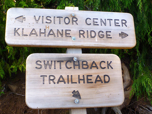
I started from the Visitor’s Center up the Sunrise Trail. And followed the signs for Lake Angeles.

Soon I side tripped a mad scramble up Mt Angeles. Good fun.
The pretty trail winds steeply up and up.
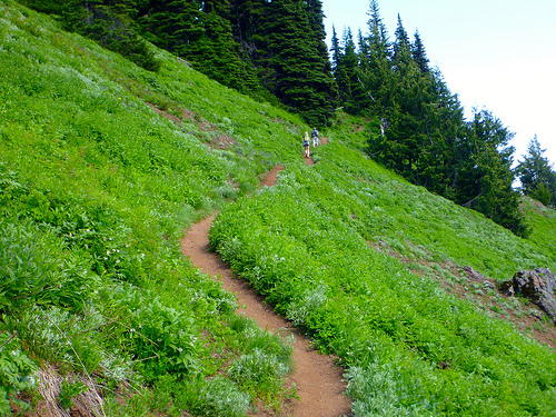
The roadway up to Hurricane falls away below.
The higher you climb, the more rugged it gets.
At points you must guess where the trail lies, under the snow. I took the chance to do some glissading.
Klahhane is pretty. No doubt about it.

I was sorry to see the climb end.

Finally. A glimpse of Lake Angeles far below.

During the slippery, steep descent I fell once. Landing (correctly) on my backpack. No injury.

I’m no real fan of mountain lakes, mainly because of mosquitoes. The flying mini-vampires of Lake Angeles were the first that had pestered me in 5 days.
But I’m happy to have tented there. For some reason the campground was overrun by mountain goats. Altogether we saw 8. Mothers with new born young.

I speculated that some predator might have driven them towards humans for protection … Bears and cougars don’t want to be anywhere near people if they can help it.
Just above was where the only hiker ever died from mountain goat attack. A slight cause for worry.
Next morning I strolled out of the mountains on a quiet old growth trail.
Jeni rescued me. After 5 days, 4 nights … I finally departed Olympic National Park.
related – The Crossroad – Backpacking in Olympic National Park: Klahhane Ridge (2013)
trip report by site editor Rick McCharles
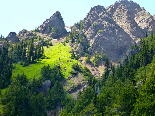
Mount Angeles is the highest point between Hurricane Ridge and the Strait of Juan De Fuca in Olympic National Park.
It offers incredible views from Canada to Mount Olympus.
It is only about 15 miles from the town of Port Angeles and is a very popular climb, both in winter and summer.
Summer offers a hike and a scramble to the top while winter offers a nice fairly easy snowclimb with a short easy chute at the end to the summit. Because this is so close to the ocean, the mountains tend to dump a lot of moisture with nasty weather. It is after all how Hurricane Ridge got its name. …
The main trail is the Mount Angeles Climbers’ Trail which switchbacks up the south side before switching over to the west side and then up a chute to the summit. There is an option on the East Ridge that offers some scrambling up the ridge to the summit. …
read more on Summit Post

I’d decided on a whim — after chatting with a descending runner on the Sunrise Ridge Trail — to try to climb the peak. Not knowing any better, I blasted straight up the face.

I took the “easy” way down. Slowly and carefully. Descending is far more dangerous than climbing.
No water. Some report mosquitoes though I had none the day I climbed.
Given its close proximity to the Hurricane Ridge Visitor Center, the climbers’ trail route is frequently climbed by determined hikers, and even a few tourists manage to reach the summit, although the mountain is far too craggy and exposed to recommend it to any but experienced scramblers.
Accidents due to slips and falls on loose rock and snow account for many accidents on Mount Angeles.
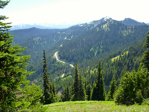
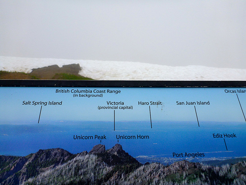
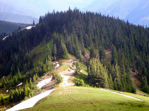
At an elevation of 5,242 feet (1,598 m), Hurricane Ridge is a year-round destination. In summer, visitors come for views of the Olympic Mountains, as well as for superb hiking. …
Spectacular views of the Olympic National Park can be seen from the Hurricane Ridge viewpoint. The road leading west from the Hurricane Ridge visitor center is dotted with picnic areas and trail heads.
A paved trail called the Hurricane hill trail is popular with visitors, and is about 1.6 miles long (one-way) with an elevation gain of about 700 ft. It is not uncommon to find snow on the trails even as late as July. …
Hurricane Ridge is named for its intense gales and winds. The weather in the Olympic Mountains is unpredictable …
Don’t drive up the mountain before checking weather conditions.
Hurricane Hill is great.

Sadly I got the the more typical vista when looking north to Canada. Nothing but cloud.
It started to clear as I descended.
Most visitors drive up. Take one of the wheelchair accessible walks, consume 1000+ calories at the snack bar. And drive on.
The biggest problem at Hurricane ridge, is this.

Many wild animals get accustomed to humans. There’s supposedly never been a bear encounter in the park, but there have been animal encounters.
For example … A deer first followed. And then charged a leashed dog.
Click PLAY or watch it on YouTube.
Owner not much help. 😦
In bright sunshine, however, it’s difficult to beat Hurricane Ridge. I like it even better than Logan Pass, the equivalent at Glacier National Park.

more of my photos from Hurricane Ridge
flickr photos tagged “Hurricane Ridge”