2012.
Nice edit. Helpful for those contemplating a future LONG hike.
Click PLAY or watch it on Vimeo.

Best hikes, treks, tramps in the world.
2012.
Nice edit. Helpful for those contemplating a future LONG hike.
Click PLAY or watch it on Vimeo.
Here’s ANOTHER (fairly) new long distance trail.
The Pacific Northwest Trail (PNT), now designated as the Pacific Northwest National Scenic Trail, is a 1200 mile hiking trail running from the Continental Divide in Montana (connecting it with the Continental Divide Trail), through the northern panhandle of Idaho, to the Pacific coast of Washington’s Olympic Peninsula. It traverses the Rocky Mountains, Selkirk Mountains, Pasayten Wilderness, North Cascades, Olympic Mountains, and Wilderness Coast. The trail crosses three National Parks and seven National Forests. The trail was designated a national scenic trail in 2009. …
The trails route was first conceived and explored by Ron Strickland in 1970. …

related:
Ron Strickland – The Pacific Northwest Trail, a National Scenic Trail
Pacific Northwest Trail Strip Maps
Ron Strickland’s book: Pathfinder – Blazing a New Wilderness Trail in Modern America
A 33-year-old hiker has just become the first person to hike a proposed trail that spans roughly 800 miles across Oregon’s high desert.
The trail runs from Bend to the Owyhee Canyonlands near the Idaho border. The Oregon Desert Trail — as it’s being called — connects many wilderness areas and proposed wilderness areas. …
read more – 800 Miles Of Juniper And Jack Rabbits: First Hiker Completes Oregon Desert Trail
Click through that link to hear an audio interview with Sage Clegg.
Water was her biggest problem. She cached some in advance in order to complete the mission.

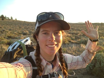
trip report by site editor Rick McCharles
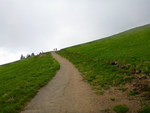
If you are talking to experienced Olympics hikers, you’ll very soon be talking about this rugged, interesting — very accessible — route.
The ridge is reached by a variety of hiking trails off of high Hurricane Ridge in Olympic National Park and offers spectacular views of the Olympic Mountains and the Strait of Juan de Fuca. In good weather.
Klahhane is a Chinook word meaning “outdoors.” It’s often misspelled. 🙂
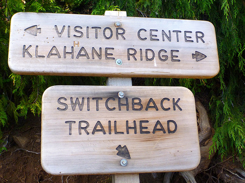
I started from the Visitor’s Center up the Sunrise Trail. And followed the signs for Lake Angeles.

Soon I side tripped a mad scramble up Mt Angeles. Good fun.
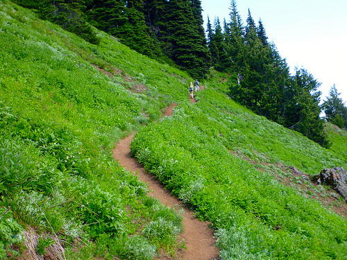
The pretty trail winds steeply up and up.
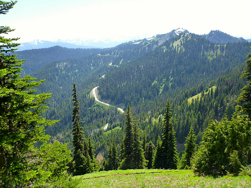
The roadway up to Hurricane falls away below.
The higher you climb, the more rugged it gets.
At points you must guess where the trail lies, under the snow. I took the chance to do some glissading.
Klahhane is pretty. No doubt about it.

I was sorry to see the climb end.

Finally. A glimpse of Lake Angeles far below.

During the slippery, steep descent I fell once. Landing (correctly) on my backpack. No injury.

I’m no real fan of mountain lakes, mainly because of mosquitoes. The flying mini-vampires of Lake Angeles were the first that had pestered me in 5 days.
But I’m happy to have tented there. For some reason the campground was overrun by mountain goats. Altogether we saw 8. Mothers with new born young.

I speculated that some predator might have driven them towards humans for protection … Bears and cougars don’t want to be anywhere near people if they can help it.
Just above was where the only hiker ever died from mountain goat attack. A slight cause for worry.
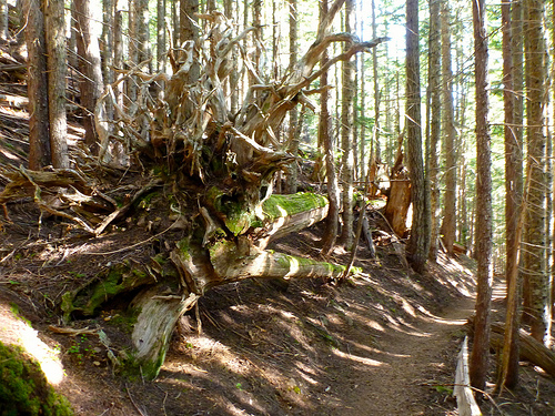
Next morning I strolled out of the mountains on a quiet old growth trail.
Jeni rescued me. After 5 days, 4 nights … I finally departed Olympic National Park.
related – The Crossroad – Backpacking in Olympic National Park: Klahhane Ridge (2013)
trip report by site editor Rick McCharles
Mount Angeles is the highest point between Hurricane Ridge and the Strait of Juan De Fuca in Olympic National Park.
It offers incredible views from Canada to Mount Olympus.
It is only about 15 miles from the town of Port Angeles and is a very popular climb, both in winter and summer.
Summer offers a hike and a scramble to the top while winter offers a nice fairly easy snowclimb with a short easy chute at the end to the summit. Because this is so close to the ocean, the mountains tend to dump a lot of moisture with nasty weather. It is after all how Hurricane Ridge got its name. …
The main trail is the Mount Angeles Climbers’ Trail which switchbacks up the south side before switching over to the west side and then up a chute to the summit. There is an option on the East Ridge that offers some scrambling up the ridge to the summit. …
read more on Summit Post

I’d decided on a whim — after chatting with a descending runner on the Sunrise Ridge Trail — to try to climb the peak. Not knowing any better, I blasted straight up the face.

I took the “easy” way down. Slowly and carefully. Descending is far more dangerous than climbing.
No water. Some report mosquitoes though I had none the day I climbed.
Given its close proximity to the Hurricane Ridge Visitor Center, the climbers’ trail route is frequently climbed by determined hikers, and even a few tourists manage to reach the summit, although the mountain is far too craggy and exposed to recommend it to any but experienced scramblers.
Accidents due to slips and falls on loose rock and snow account for many accidents on Mount Angeles.
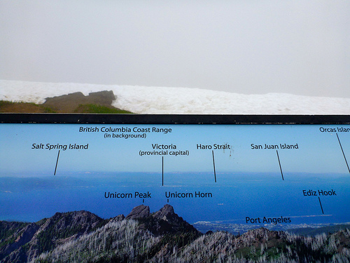
At an elevation of 5,242 feet (1,598 m), Hurricane Ridge is a year-round destination. In summer, visitors come for views of the Olympic Mountains, as well as for superb hiking. …
Spectacular views of the Olympic National Park can be seen from the Hurricane Ridge viewpoint. The road leading west from the Hurricane Ridge visitor center is dotted with picnic areas and trail heads.
A paved trail called the Hurricane hill trail is popular with visitors, and is about 1.6 miles long (one-way) with an elevation gain of about 700 ft. It is not uncommon to find snow on the trails even as late as July. …
Hurricane Ridge is named for its intense gales and winds. The weather in the Olympic Mountains is unpredictable …
Don’t drive up the mountain before checking weather conditions.
Hurricane Hill is great.

Sadly I got the the more typical vista when looking north to Canada. Nothing but cloud.
It started to clear as I descended.
Most visitors drive up. Take one of the wheelchair accessible walks, consume 1000+ calories at the snack bar. And drive on.
The biggest problem at Hurricane ridge, is this.

Many wild animals get accustomed to humans. There’s supposedly never been a bear encounter in the park, but there have been animal encounters.
For example … A deer first followed. And then charged a leashed dog.
Click PLAY or watch it on YouTube.
Owner not much help. 😦
In bright sunshine, however, it’s difficult to beat Hurricane Ridge. I like it even better than Logan Pass, the equivalent at Glacier National Park.

more of my photos from Hurricane Ridge
flickr photos tagged “Hurricane Ridge”
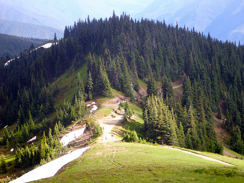
trip report by site editor Rick McCharles
The famed 7.7mi road from the Visitor’s Center to Obstruction Point trailhead 6150ft (1875m) was CLOSED for 2013 due to budget cuts. Lucky us.

A road’s a road.
But this CLOSED road is a wonderful ridge walk.

Non-stop magnificence.
Once departed the Visitor’s Center at Hurricane Ridge, I saw only 3 other people over 2 days. Two of those were trail runners.
Starting late in the day, I decided to stop at an unofficial campground near the P.J. Lake Trail turnoff. A nice quiet spot but one without water. We’re too high here.
Next morning I arrived Obstruction Point Campground.
Campground?
It’s nothing but a parking lot with a toilet.

No water. But I found a nice snow melt runoff stream nearby. No mosquitoes. 🙂
On the bright side, it was nice to stash pack with food in the biffy. Away from critters.
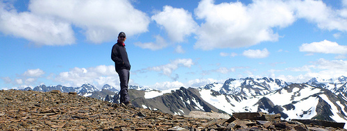
Ridge hiking out of Obstruction is unbelievable. I’ll let the photos prove my point.


I made an afternoon scramble of Moose Peak, a highlight.
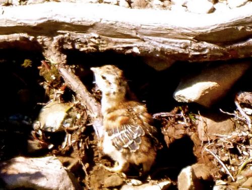
Ptarmagin must be the stupidest birds on the planet. How do they survive?

This dumb mother was doing a terrible job of protecting her new chicks.
The only other hiker tenting at Obstruction that night was from Denmark. With the good weather report, he’d bought gear at REI and driven straight to Hurricane Ridge.
Found himself in Heaven.

Next morning I enjoyed coffee with a superb vista.
I’d hoped to take the GRAND Ridge Trail in the direction of Deer Park. … But Rangers had warned that it was probably impassable without an ice ax.
Yep.
After making an attempt to climb over the steep snow. And under the steep snow. I gave up.
But I’ll be back. 🙂
There are two ways to explore The Subway (the Left Fork of North Creek). …
From the Bottom Up
This is a strenuous 9-mile round-trip hike through the Left Fork of North Creek that requires route finding, creek crossing, and scrambling over boulders. …
From the Top Down
This is a strenuous 9.5-mile hike that requires rappelling skills, 60 feet of rope, and extensive route finding experience. The route also requires swimming through several deep pools of very cold debris-filled water. …
Subway Permits are awarded by lottery. Occasionally walk-in permits are available the day prior.
Click PLAY or watch a well edited trip video on YouTube.
November through March no permit is necessary.
Hmm …
Thanks George.
trip report by site editor Rick McCharles
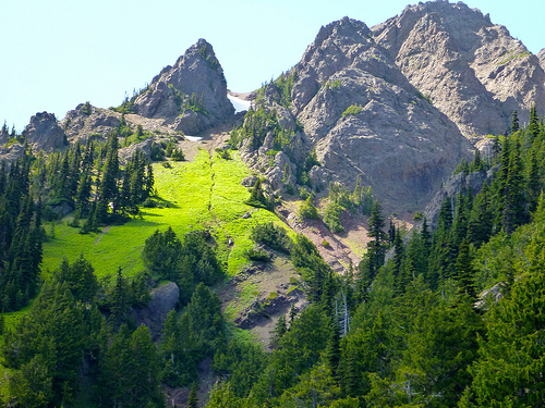
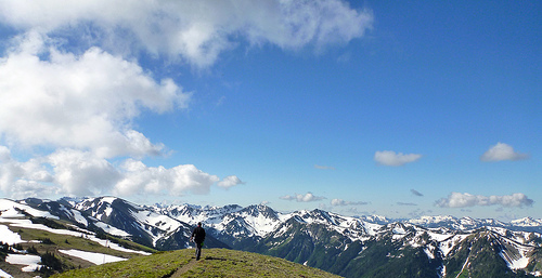
My FUN adventure in Olympic National Park Washington State.

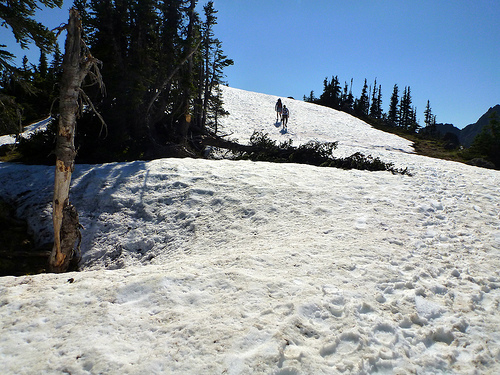
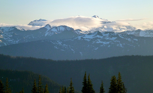
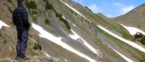
You MUST have good weather. Otherwise, stay low. Obstruction Point is already high at 6100ft. The summit of Moose is 6753ft (2058m).
It’s mostly gorgeous alpine meadow ridge walk in the direction of Moose Lake. There was some snow left on the trail on July 4th, but nothing to worry about.
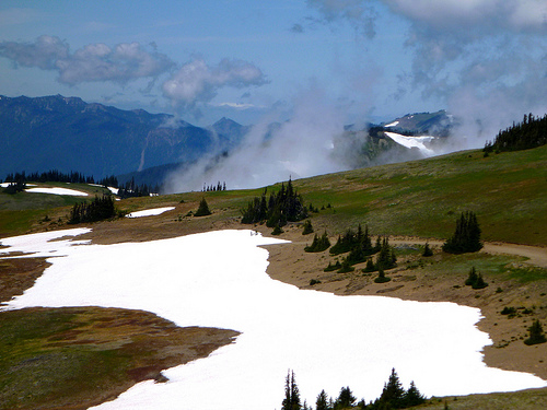
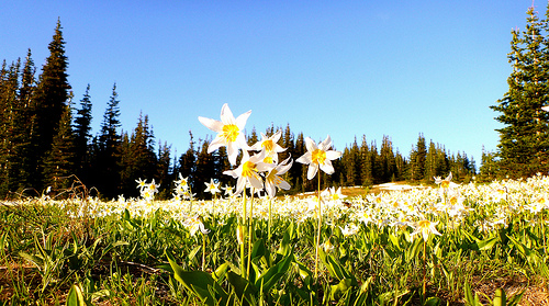
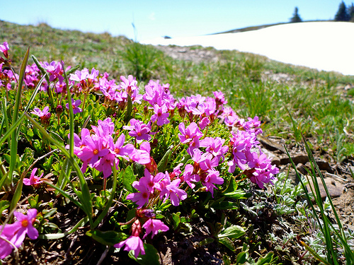
Hikers enjoy the wild flowers this early in the season.
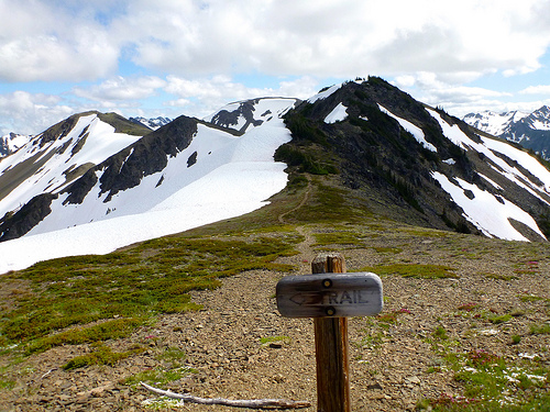
Head on the trail towards Grand Lake, Moose Lake, Grand Pass. It’s about 2mi to the “Grand Valley” trail cut-off, elevation 6450ft.
You’ll know you’re there when you see this TRAIL sign.
Some trip reports found the ridge scramble fairly easy.

I actually found it challenging. Depends on the route, I guess. I stayed as high on the ridge as possible on the way out. … Took the lower (obvious) easy trail across the scree on the return.
Fantastic views on top, of course. Those are Grand and Moose Lakes below.

I left a Summit Stone.
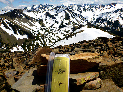
LOVE Moose Summit. 🙂
Moose is not named after Moose, surprisingly. It’s named after some guy with the last name of MOOSE.
There is no water high in the Olympics. Bring your own. Or melt snow.
related:
• Explore Olympics – Gary Huff – Moose Mountain
• Summit Post – Moose Peak
This photo of a bridge in Claviere, Italy, about 80 km west of Turin, on the border with France has been widely circulating on the internet.
Looks like FUN. 🙂

Thanks Dana.
