… It seems like an age ago since I first met Mike, I was looking for some company to trek up to Annapurna Base Camp in the Nepal Himalaya. Although this is a easy route to tackle on your own, I believe that sometimes moments are best shared with two.
Posting a thread on Lonely Planet’s Thorn Tree Forum looking for people, I received an email from a Yorkshire man who was currently cycling around and across Nepal, but wanted to leave his bike behind for some good old fashioned walking.
We caught up in Pokhara, by Phewa Lake for a beer and a cheeky Western treat of Pizza. …
You’re currently in South America, what has it been like and where have you been?
… I started my travels in Buenos Aires, dubbed the Paris of South America. I spent a month learning Spanish and exploring this colourful and vibrant city. From there I travelled to Argentina’s southernmost city; Usuhaia. El Fin Del Mundo (The End of the World) and started my trip north toward Columbia after a last minute trip to Antartica. I cycled through Patagonia, the Argentinan and Chilean Lake Districts before stopping off for a breather and a slice of city life in Santiago and Valpariso.
From there I linked up with the spine of the Andes and rode through the Argentina wine growing areas of Mendoza and Cafayate before crossing in to Boliva and spending over 6 weeks on the Bolivian Antiplano crossing the spectacular Salar De Uyuni. I am currently in the heart of the Peruvian Andes, and plan to follow these north as closely as possible. …
A cable car will open September 2015 or sooner, degrading the hiking experience. The Sapa area is great, but trek elsewhere in the region. This summit will soon be flooded with suitcase tourists. 😦
Below is our old information page, no longer being updated.
Update (this is an exception 🙂) from patriciaoprea March 2017:
I paid about 60 USD the night before (I’m so last minute) for a tour from Sa Pa
It was 2 days,1 night.
The good thing about this? We arrived at the summit at 7:00 in the morning.
The cable car is built, but NOBODY is there at that hour, because it hasn’t opened yet!
I loved this hike, go for it 🙂
AT A GLANCE
3,143 meters (10,312ft), it’s the highest in Indochina
Northwest region of Vietnam, near the Chinese border
9km southwest of Sapa (Sa Pa), a gorgeous hill station developed by the French
1-3 days hiking
pine forests, bamboo thickets and jungle
best months October through April. Some say April and May are best as it’s warmer. And the flowers are in bloom.
avoid the wet season from June to September, with heaviest rainfall occurring in July and August
record for scaling Fansipan is one hour and thirty-five minutes, in case you want to better that time. 🙂
Panoramic views of the mountain ranges of northwest Vietnam, if you get any views at all. The summit is famously shrouded in cloud.:-(
Why We Like This Hike
about 2,024 floral varieties and 327 fauna species (sadly many of the larger animals have been hunted out)
no ropes or technical climbing skills are needed
plaque at the peak placed February 2007
colourful minority ethnic people, especially on market days
ridge walk sections were our favourite
Considerations
malarial mosquitoes can be a danger some months of the year
bring warm clothes. Temperatures below freezing are frequent.
snow is possible
climb is rough, wet, muddy and cold. Some bring rubber boots.
gloves with good grips recommended for ladders and rock scramble
scramble ladders and tree roots
you may be clutching bamboo at points
we’ve seen warnings about poisonous snakes, leeches, rodents, perhaps exaggerated
dogs are a worry, both in Sapa and on the trail. Even if you don’t carry a trekking pole, you might want to carry a stick
Sapa is a tourist trap. Touts are a pest.
Cost
Guided trips are no longer asinexpensive as they once were. Seems the government got stricter with guide requirements.
We paid $95 for a one day, up-and-down for 1 person October 2014.
A two day trek costs $180 for 1 person October 2014. You can negotiate on price with some agencies.
Shop around. The official government tourist information office quoted $120 for the $95 tour. Assume the difference is commission.
Routes
There are a number of options, including a 1 day guided up-and-down.
It’s possible to do independently. But we wouldn’t recommend it unless you are familiar with the route.
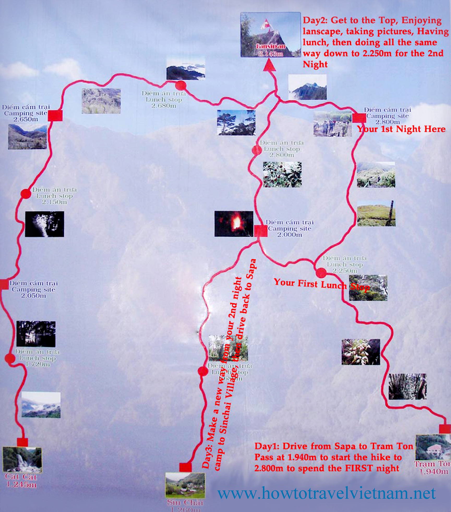
click for larger version
There are three routes to the mountain. One is from Tram Ton, the others from the villages of Sin Chai and Cat Cat.
The first route is a more gradual climb because it has been selected for tourists. The trip can be made in a day.
The route from Sin Chai is shorter but more adventurous, requiring climbers to sometimes use ropes or other special facilities for climbing.
The route from Cat Cat is the longest, but mixes some challenging climbs with great scenery. After one day of climbing, there’s a break at 2,200m above sea level. Climbers can have a meal cooked by a Mong porter and camp, followed by a second camp at 2,700m before reaching the peak on the third day.
Most climbers chose a tour from Sa Pa at a cost of about VND1.5 million excluding train fare from Ha Noi, and tours should be booked a month in advance.
many hikers arrive by overnight train from Hanoi to Lao Cai, then bus from Lao Cai to Sapa. Those tickets sell out during high season, especially during holidays, as Sapa is super popular with Vietnamese.
even better, some feel, is the night sleep bus direct from Hanoi
we stayed at the Sapa Unique Hotel for about $35 / night. It gets rave reviews.
We recommend you hire a guide. Let them do the logistics. You simply enjoy the journey.
on the most popular route up from the Ranger Station Camp 1 is located at around 1,500m (4,920ft). Simple accommodation and food are offered.
at 2,800m (9,190ft) is Camp 2. Sleeping is communal in a very poorly maintained ‘hut’. Might have rodents. Have your agency bring tents, instead. Camp 2 is trashed and unsanitary.
Last day – 1200mi hike. Glacier National Park in Montana to the furthermost western point on mainland USA.
Gear Junkie:
… There was no sign; no monument; no finish line. I just stared at the tiny arrow on the end of the track on my GPS, and then turned down the cedar plank path toward the nearest road. The Pacific Northwest Trail had been the most rugged, challenging, beautiful, and rewarding nine weeks of my life; full of highs and lows, triumphs and hardships, close calls and immense pleasures; and now it was done.
Jeff Kish hiked the 1,200-mile Pacific Northwest Trail this summer. This is his final report from the trail. See Kish’s full collection of trip reports and gear reviews at GearJunkie.com/PNT.
Misti at 5822m (19,101ft) is one of the easiest, most visible, most popular, most accessible high summits in the world. It is recommended for all self-sufficient hikers. If you tolerate cold & altitude symptoms, the ascent is little trouble in good weather.
Misti is one of the best trekking peaks in the world — no mountaineering skills nor gear needed if the weather is good
3 days, 25km circuit plus the climb is recommended. Most do it in 2 days, 1 night, however.
Easy access from Arequipa, our favourite city in Peru.