Hiker’s Guide to Cyprus

guest post by Hollie Mantle

Cyprus doesn’t necessarily strike you as the number one hiking destination, but in fact the dramatic scenery, mountains and coastal paths make it a fantastic place for walkers of any experience level. Here are three tried and tested walks you might want to try (though you can definitely find others, and even accidentally stumble on to others whilst finding these!)

photo by Bald Hiker
photo by Bald Hiker

Aphrodite Trail

Start Point: Baths of Aphrodite

Distance: 8 kilometres. At the utmost peak you’ll reach 370m.

Best for: This hike is for those who are serious about walking; first timers might want to skip this one and head straight into the Baths of Aphrodite or grab some lunch on the terrace. The walk involves some steep uphill climbs, so pack proper walking gear (and don’t even whisper the word ‘flip flops’). Keen photographers will also enjoy this walk as you’ll get some cracking shots over the Akamas Peninsula; there’s definitely satisfaction to come at the end of the struggle with this one.

Time it takes: 3-4 hours depending on how leisurely you’re planning to amble.

Why it’s great: This is renowned as one of the most beautiful trails in the whole of Cyprus.

How to get here: If travelling from Paphos, take bus 645 from Karavella bus station to Polis. This journey takes roughly 50 minutes and leaves on the hour from 8am. From there, change to the 622 to the Baths of Aphrodite. This takes about 30 minutes and again leaves on the hour.

Where to stay: There are loads of stunning hotels – you can check the reviews on TripAdvisor to see which suits!
___

Agros Kato Mylos Nature Trail

Start point: Near the Rodon hotel.

Distance: 6 kilometers.

Best for: Seeing vineyards, orchards, and the rose bushes which the small town is famed for – the annual rose festival takes place in May when thousands of roses are picked to make rosewater. There are also feasts, dances, and ceremonies that attract a lot of tourists during this month. This walk is average in terms of difficulty, but is easier than the other two listed, if a little dangerous and slippy at points.

Time it takes: 2 hours.

Why it’s great: Agros is really tiny, with a population of only around 800. This means you can really escape the tourist clap-trap here and get back to nature without touts trying to sell you knock off souvenirs or overpriced restaurants. The locals are warm and welcoming, and you’ll get a taste of what life is like in rural Cyprus whilst gobbling down some of the most glorious food on the whole of the island. The locals have a lot of traditional syrupy sweets which are also worth a try.

How to get here: 90 minutes from Pathos International Airport – so if you’re not adverse to the idea, rent your own car and drive (there’s not so much in the way of public transport in this area)

Where to stay: Given the size of the place, hotels are few and far between, but you can check out reviews for a few of them here. Rodon is popular with people around Greece who like to get out of the city at the weekends, or for people in the area looking for a great dining experience. The name means ‘rose’ and has added considerably to the economy of the region!
___

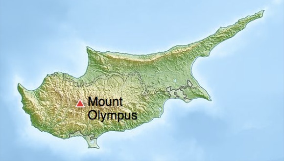
Troodos Trails: Artemis

Starting point: The start is at a small brown hut on the road leading up to Chionistra (Mount Olympus). Take the narrow track immediately to the left of the brown hut (do not follow the signs which suggest it’s the other way – it’s all lies at that point!)

Distance: 7 km. 1850m altitude.

Best for: Great views! This walk is recommended for experienced walkers who are prepared for the rough terrain, or just holidaymakers who fancy a scenic walk and aren’t scared of putting in a little legwork and being careful on the rocks. (Or those with super dodging skills if you decide to go in winter – you might get knocked off the path by passing skiers).

Time it takes: 2-3 hours.

Why it’s great: Goes around Mount Olympus in the Troodos Mountains. This site is often home to weddings, wine lovers coming for tasting sessions and skiers during the winter. You can get some spectacular long distance views when the weather is good(on a really clear day in the winter you can sometimes see out to the coast at Limassol). There are also lots of ruins set into the mountain sides. Best to head out later in the season rather than summer, when the flowers will be in full bloom. (Although don’t go too late, because in winter it won’t be a trail so much as a ski slope).

How to get here: This site is really useful if you’re planning on travelling around by bus. Or rent a car – it’s a 1 hour 15 drive from Pathos International Airport.

Where to stay: You can find a write up of family run hotels and more rural retreats here. Olympus Cyprus

Danny Macaskill: The Ridge

#TheRidge is the brand new film from Danny Macaskill… For the first time in one of his films Danny climbs aboard a mountain bike and returns to his native home of the Isle of Skye in Scotland to take on a death-defying ride along the notorious Cuillin Ridgeline.

Click PLAY or watch it on YouTube.

new Nepal trekking regulations?

I’ve just arrived Kathmandu.

Officials in Nepal say they plan to introduce tougher controls of the trekking industry, a week after a devastating Himalayan storm.

In future, all trekkers will be required to register before setting out on the Annapurna circuit, they told reporters.

Only properly trained and accredited guides will be able to lead treks. …

BBC – Nepal plans to tighten rules on trekkers and guides

This news report, like many I’ve seen in the mainstream media, are not accurate. Click over to wikipedia for ongoing updates and an a more objective overview of the tragedy.

Not clear in the media is that all Annapurna trekkers already must register to get their ACAP permit. All Guides are trained and certified.

My best guess is that independent trekking will still be allowed in 2015. The director general of the Department of Tourism, Tulasi Gautam, has to say something.

This for example:

… In future, all trekkers must register at check posts when they enter and leave the popular trail (Annapurna), officials said. …

On Annapurna, Everest, Manaslu, etc., you already check in with multiple checkpoints. It’s been that way for decades.

related – Picturing the Blizzard That Caused Nepal’s Worst-Ever Mountaineering Disaster:

blizzardI’ll be careful. Don’t worry.

climbing Fanispan in a day

trip report by site editor Rick McCharles

“the Roof of Indochina”

AT A GLANCE

  • map Fansipan3,143 meters (10,312ft), Fanispan is the highest mountain in Indochina
  • northwest region of Vietnam, near the Chinese border
  • 9km southwest of Sapa (Sa Pa), a gorgeous hill station developed by the French
  • pine forests, bamboo thickets and jungle

Oct 20, 2014

P1310402

Breakfast at the fantastic Unique Hotel starts 7am. Since I was leaving at 5am, the cook awoke early and put together a takeaway breakfast for me. 🙂

I arrived at Sapa O’Chau travel agency at 5:10am for the 5:30 rendezvous. Guide and driver were there already, so we departed instantly.

By 5:30am we were marching briskly up the trail. In the dark.

“Silver”, my guide, spotted a wounded bird near the Ranger Station. Knowing that some dog would dispatch him in the morning, he carried the bird along with us until finding a safer place in the forest.

P1310342

We started early because I opted to climb Fanispan in one day US$95, rather than the normal US$180 2-day itinerary.

P1310348

Silver quickly decided I was strong enough to make it. I hoped he was right.

The trek is wet. And muddy. At the bottom you are often walking in creek beds and runoff streams.

P1310355

Happily for me, it had been very dry of late. My feet did not get wet over the entire day!

The best sections are ridge walks with misty valley vistas far below.

P1310436

P1310442

Surprisingly, long sections of the ridge are protected with concrete railings. They are well built and seem to be enduring the climate very well.

P1310435

I asked my guide about poisonous snakes. He laughed, saying the snakes this high are very wary. People don’t see them. But in his village, Kat Kat, there are many, many.

P1310358

Just around the next corner we came across that one, bludgeoned to death. Silver was sorry to tell me that his people eat large snakes and kill small ones.

You’ll only see goats and buffalo on this trek. For anything more exotic check the restaurants of Sapa. Some Asians are happiest eating the most endangered species. 😦

porcupine Sapa

Almost everyone climbs Fanispan with a guide. But I did talk to one guy from Hanoi who did it alone. In a day. Much faster than me. Parts of the trail are marked with collapsed signposts and fading red markers.

P1310362

It would be easier to follow the trash, however. Only western tourists and guides pack out what they pack in. I’ve always found indigenous peoples to be the very worst litterbugs.

This day we were first to arrive at Camp 1 – 1,500m (4,920 ft). You can buy snacks and drinks here. The guard dog was chained.

P1310366

P1310368

Up and up. Into the clouds. Fanispan’s summit is usually clouded over.

P1310375

P1310377

Multiday hikers normally stay at Camp 2 – 2,800m (9,190 ft). Either in fairly dirty buildings or in much cleaner tents carried by porters.

P1310390

We had a meal here on the way up. And on the way down.

P1310391

P1310430

Though I set out my alcohol gel, my guide didn’t use it. Other cooks I saw were equally unsanitary.

Camp 2 is atrociously trashed. The main reason I chose to do a one day climb was to avoid staying here. 😦

If you feel I’m exaggerating, click over to a photo of the toilet.

This is a tough trek. There are dozens of sections where you really need to scramble. Many inexperienced hikers must turn back.

Here’s one essential handhold.

P1310420

Though in a hurry, we got stopped high up for 30min because a work crew was blasting rock.

P1310416

P1310421

Turns out a cable car is being built. It will open September 2015 or sooner. There must have been 200 workers living atop this high mountain.

P1310410

P1310411

P1310412

I took perverse pleasure in seeing this mess, but I’m not going to recommend Fanispan to others. The cable car will further degrade the hiking experience.

We did finally stand on the summit, the highest spot in Indochina.

P1310405

I assumed it would be quick down. But we didn’t get back to the Hoàng Liên National Park Ranger Station until 5pm.

That was 11.5hrs up and down. Including 2 half hour stops for food.

I was awarded a certificate and medal. 🙂

P1310458

I could barely walk that evening. But seemed to be completely recovered next morning. 🙂

See my high resolution photos from this adventure on flickr.

See our old information page – Fansipan, Vietnam – not recommended


Simien Traverse, Ethiopia

I’m hoping to do the famed Simien Traverse in early December 2014. I’ll be in country Dec 1-14th. It’s the best hike in Ethiopia, one of the best in the world.

Simien

Click PLAY or watch a some highlights from a 2014 trek on YouTube. It looks spectacular. Scenery and wildlife. Especially the Gelada Baboons.

I’m using the most recent Lonely Planet Ethiopia to start my research.

I plan to fly Addis Ababa to Gondor, buying my ticket when I get to Ethiopia. Spend at least one night in Gondor, acclimatizing, before traveling about 2hrs north to Debark.

map2

The Simien Park Hotel in Debark is reputed to have hot water showers. One night there while I organize my adventure at the National Park Office.

I’m hoping to either join a group headed up or to hire the minimum for a solo trek. That’s one ‘Scout’ (armed park ranger) and one English speaking guide.

No mules. No cook.

The most popular route is 4-5 days to Geech or Chenek and back. I’ll not summit Ras Dashen, the highest peak in Ethiopia.

Leave a comment if you’ve done this trek.

deaths on the Annapurna Circuit

Rescuers in Nepal are trying to reach more than 20 trekkers trapped below a high Himalayan pass by heavy snowfalls and avalanches as the death toll from the unfolding tragedy was reported to be as high as 32.

High winds and blizzards hit much of central Nepal this week as the tail end of a cyclone travelling west across northern India reached the Himalayan mountain chain. The head of the Trekking Agencies Association Nepal said there had never been a disaster like it. …

Local officials said 24 bodies had been found on the Annapurna circuit, which circles the Annapurna mountain and attracts thousands of walkers every year.

Guardian

I was there last year. In perfect weather. 😦

Thorong La, 5,416 m (17,769 ft)

There was a similar disaster some years ago. Many killed. Many hikers trapped at the Annapurna Sanctuary.