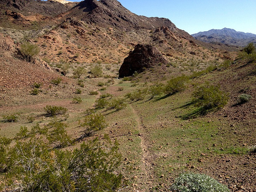
Expedition Alaska Adventure Race

I’m planning to volunteer for Dave Adlard’s NEXT expedition race. Social media. Photos. Video.

June 28th – July 4th, 2015.

Over almost 7 days, teams will undertake a 340 – 600 km (200 – 350 miles) expedition over some of the most beautiful, epic and challenging terrain on Earth.

Racers will use a map, compass and their own wits to navigate their way over a (mostly) unmarked route by mountain biking, rafting, paddling, trekking, canyoneering, coasteering, glacier travel, orienteering, trail running, fixed ropes, and a few other surprises through the amazing expanse of Alaska’s Kenai peninsula!

expeditionak.com

Expedition Alaska

Long Range Traverse, Gros Morne

Gros Morne National Park is a world heritage site located on the west coast of Newfoundland. …

Gros Morne is a member of the Long Range Mountains, an outlying range of the Appalachian Mountains, stretching the length of the island’s west coast. …

Hiking the trails is a popular activity at Gros Morne. There are about 20 marked day trip trails, exploring coastal and interior areas of the park. …

The interior of the park can also be accessed, notably through the multi-day Long Range Traverse between Western Brook Pond and Gros Morne Mountain. …

Leigh McAdam:

Before you even get a whiff of the Long Range Traverse, the premier backpacking trail on Canada’s east coast, you must pass a serious navigation test and get a full orientation by staff at the Gros Morne National Park Visitor Center.

The navigation test is nothing to sneeze at. You must understand declination and know how to take a compass bearing from the map. Although you can take along a GPS, and it might help in foggy situations, it’s your map and compass skills that are of utmost importance. It’s the only place in Canada that I am aware of that requires you to pass a navigation test. I guess what happened in the past, is too many backpackers set out, only to get lost – as there is no marked trail – and ended up needing a rescue.

Hike Bike Travel – Backpacking the Long Range Traverse in Gros Morne NP: Day 1

campsite night 1

Long-Range-Traverse-462hsrs

Day 2

Day 3

Day 4

Long-Range-Traverse-481hsrs

treking Iceland north to south

A short video showing some of the highlights of our traverse of Iceland during the summer of 2014. It took us 21 days to cross about 500km from the northern shore at Hraunhafnartangi to the southern coast at Skogar. …

We had 2 food parcels on the route – one in myvatn and another in landmannnalaugar. This meant the maximum amount of food we had to carry was 12 days giving a backpack weight of between 15 and 25kgs. We also got caught in a storm in the highlands midway through and had to use our SPOT device to get picked up by Iceland’s amazing Search and Rescue volunteers …

http://vimeo.com/101096882

(via Hiking in Finland)

Roof of Yosemite Loop

Leor Pantilat seems to have invented his own high Sierra route:

The Roof of Yosemite Loop travels to the highest point in Yosemite National Park on 13,114 ft Mount Lyell and also includes ascents of 12,900 ft Mount Maclure (5th highest in the park) and 12,561 ft Mount Florence (9th highest in the park).  …

The Roof of Yosemite Loop combines many of the highlights of this region into an aesthetic and highly scenic loop. …

 
lyell02

roof_of_yosmite_loop

Leor Pantilat’s Adventures – The Roof of Yosemite Loop

That looks one wild and challenging adventure. 🙂

I believe I saw this linked from Hiking in Finland.

hiking Sargent Mountain, Acadia

I’d planned to hike Giant Slide Trail & Grandgent to Sargent Mountain based on this list of best hikes in Acadia National Park.

Without hiking guidebook or map, Acadia trails can be confusing.

IMG_2051

There are many, many ways to get to the top of Sargent. (also spelled Sargeant)

My particular route was pretty.

IMG_2054

IMG_2059

By luck, I happened upon a Ranger who recommended Sargent Mountain via Sargent Ridge.

IMG_2063

Soon after, I zigged instead of zagged.

And was off on another trail instead.

Earl—the Rugged, Revolutionary Tablet

Leave the iPad at home.

Outside:

This new backcountry survival Android tablet works where your smartphone or iPad would fail. The rugged tablet can forecast the weather, determine your location, elevation, and let you communicate with folks back home.

About the size of an iPad mini, Earl is one tough gadget. It’s waterproof, dustproof, shockproof, and it will work in temperatures from 32 degrees to 122 degrees Fahrenheit. You can submerge it in three feet of water for up to 30 minutes with no ill effects.

Earl’s GPS uses an internal magnetometer, accelerometer, and gyroscope to track your position. It’ll guide you even if you’re navigating dense vegetation or an urban jungle without a line of site. It also gives you access to more than 300,000 trails through the site everytrail.com and high-resolution topographical maps of North America. With Earl in your hand, you have no excuse to get (unintentionally) lost. …

earl-survival-tablet_fe

Outside

where’s Dead Burro Canyon?

… I really need to start hiking with a GPS. 😦

I set out into the Arizona desert with typically vague details I found online.

Dead Burro Canyon Trail is a loop hike for the adventurous around a mountain block through a deep scenic canyon in Havasu National Wildlife Refuge, a wilderness setting where very few trails exist. Look for wild burro and Bighorn sheep! …

As expected, I was quickly lost.

One wash looks much like the next.

wash

On the other hand, I enjoyed a solo morning off trail. It’s all good in the desert outside Lake Havesu, Arizona in February.

desert trail

I dropped a Summit Stone atop one random stone mountain.

Summit Stone

The highlight was finally spotting wild burros. LIVE ones.

burros

There were over 2000 of these beautiful animals running wild in Arizona as of 2010. They are regulated by the Wild and Free-Roaming Horses and Burros Act of 1971.

more photos

If you actually want to reach Dead Burro Canyon, my advice is to download the GPS track.

Sprawson – Overland Track

A new guidebook for our favourite trail in Australia.

The Overland Track: Cradle Mountain to Lake St Clair

by Warwick Sprawson

details on Red Dog Books. ($39.99) Check also the website for the book.

Just the other day I recommended the classic hiking guidebook for The Overland by Chapman. About half the price.

On the other hand, this new competitor by Sprawson garnered some praise from Frank in Oz. His site is definitely the best source of information on the Overland, online.

In fact, you might simply want to download Frank’s Overland eBook, and refer to that PDF from your mobile device. It’s also less expensive than Sprawson.

All good options.

Check our Overland Track information page. It’s one of the top 10 treks in the world.

Google Sherpa-Cam on Everest?

Daniel on the CheapTents Outdoor Gear Blog:

… The next development for Google Street View will involve getting off the trike and moving onto mountain trails, which will require leg power alone. For this Google … developing the Sherpa-cam. Prototypes are currently being trialled in the Lake District and in the Nepalese Himalayas. …

Here’s some Photoshop speculation on what that might look like.

read more – Street View on Mountains with Google Sherpa-Cam

… It’s only a matter of time.

Google has updated their Street View website, by the way.

check out peakery.com

Scott announced the cool new site – Peakery.com

Featuring over 150,000 peaks from around the globe. Find peaks by browsing lists, maps, and photos.

Use peakery to envision your next peak objective with photos, trip reports, stats, and maps. Then get out there and bag it.

peakery is the place to log your summits. Add trip details, triumphant summit photos, and get summit badges.

Check it out – Peakery.com