Anniversary Narrows, Lake Mead, Nevada

trip report by site editor Rick McCharles

As beautiful a slot canyon as any other on earth.

How could I resist?

That claim made by one of my guidebooks, Afoot and Afield Las Vegas, the best of those I used.

Simple.

Drive to this trailhead. …

Anniversary Narrows, Lake Mead, Nevada

An easy 2.5mi out-and-back.

Unfortunately, I didn’t do that.

Instead I parked on the highway, not trusting my low clearance vehicle to make it to the trailhead. This added about 2.5mi to the trip.

En route a couple of hikers told me I was off-route. They could not find the trailhead. (It was there.)

I diverted to the only other possible watercourse, following footprints down a dry creek. It looked feasible.

WRONG.

I circumambulated a minor peak on a scramble soon dubbed the DANGER MINE trail.

Anniversary Narrows, Lake Mead, Nevada

There must have been a dozen old mine shafts up there, right to the top of the peak.

Finally I spied hikers far below. On my original, correct route.

Anniversary Narrows, Lake Mead, Nevada

Anniversary Narrows are lovely.

Anniversary Narrows, Lake Mead, Nevada

Rick straddling Anniversary Narrows, Lake Mead, Nevada

Recommended. But another cautionary tale of how easy it is to get lost in the desert. It’s possible to fall into an abandoned mine shaft out there, too.

The crumbling ruins of the mining operation are a historical attraction.

Anniversary Narrows, Lake Mead, Nevada

see all my photos from this trip

Dave Adlard climbs Mt Ranier

When I gave Dave my expedition hiking pack, I had no idea he was planning to become the next insane high altitude mountaineer.

Here’s his (lengthy) Mt Ranier trip report from this past weekend:

If I live to be 100, I may never see a better day to climb, especially on the fickle Mt. Rainier.

I had been looking forward to this weekend for a while – everyone  normally “do stuff with” was out of town, and so i had noted this date on my calendar as a possibility for getting over and doing a “real” mountain. I had had no luck finding a climbing partner, and so, with a little bit of trepidation, I made the 6.5 hour drive toward Rainier on my own, with ever increasing clouds as I got closer.

Once at the Paradise visitor’s center/trailhead, I was amazed at how deserted it was… normally, on weekends and in the summer, this place is packed, but the climbing/hiking season didn’t actually open until the next day. …

Continue reading “Dave Adlard climbs Mt Ranier”

Without Baggage – on Half Dome, Yosemite

Half Dome is one of our best hikes in North America.

I loved Hank Leukart’s hilarious trip report. Check the excerpt:

… It’s a surprisingly strenuous cardiovascular workout, battling gravity to reach the top of Yosemite’s most recognizable rock formation. The normally unflappable Laura looks petrified as she slowly inches toward the peak. Finally, the three of us reach the summit, breathing heavily and sweating with adrenaline rushing through our bodies. Laura, finding that she has suddenly become terrified of heights, sits safely in the middle of the Dome’s surface, not wanting to get anywhere near the edges, though they are at least 200 feet in every direction. The three of us eat a lunch of turkey sandwiches as we look out from a height of 8,836 feet above the dramatic expanse of Yosemite Valley, with its complex granite rock formations, pine tree forests, and sprawling meadows. The epic views make us feel dizzy and drunk.

“I want to stay here forever,” I say, looking down into the Valley below.

“I never want to leave,” Justin agrees.

“I want to go down, right now,” Laura pleads. …

read the article – Without Baggage – living yosemite.

after climbing half dome, i can’t bear to leave yosemite.

why children need wilderness

Frank ties together some very interesting and entertaining links on this topic.

Just one of those is a book by Richard Louv:

Last Child in the Woods is the first book to bring together a new and growing body of research indicating that direct exposure to nature is essential for healthy childhood development and for the physical and emotional health of children and adults. …

Click through for the details and more links – Our Hiking BlogNature Deficit Disorder? Kids at risk without “wild places”?

This is 11yr-old Zach Bonner finishing his 600mi trek from Atlanta to Washington, DC on July 9, 2009

[picapp align=”center” wrap=”false” link=”term=children+hiking&iid=5340834″ src=”9/9/3/4/11YearOld_Finishes_Walk_c8bb.jpg?adImageId=12608288&imageId=5340834″ width=”500″ height=”351″ /]

Lost Coast Trail, finally

trip report by site editor Rick McCharles

For years I’d been trying to find the Lost Coast of California, listed by all one of the best Ocean walks in the world .

… The Lost Coast is a section of the California North Coast in Humboldt County, which includes the King Range. The steepness and related geotechnical challenges of the coastal mountains made this stretch of coastline too costly for state highway or county road builders to establish routes through the area, leaving it the most undeveloped portion of the California coast. …

hiking the Lost Coast Trail, California

Logistics are challenging:

• 25mi one way
• Mattole trailhead south to Shelter Cove

I arrived at the Bureau of Land Management office in Arcata, California after closing. One of the staff unlocked the door, answered all my questions on the hike, got me tide tables and the booklet called “What You Need To Know Before Backpacking The Lost Coast”.

Thanks BLM !!

A quick summary:

• camp anywhere you like, but in established sites
• beware Bear visits
• severe storms typical
• no bridges, many creek crossings
• be forewarned about ticks and Lyme disease
• all water must be treated
• don’t be surprised to find a rattle snake in a pile of driftwood
• mobile phone coverage unlikely
• it’s remote, rescue slow and difficult

A free self-service permit is required. Get it at either trailhead.

Hike the “low tide” sections while the tide is dropping. If you get “stuck”, you can simply wait for the beach to open.

We talked about the tragedy of 2000 when 2 student hikers and a parent were drowned. Terrible. The rip tides and so-called “rogue waves” are a real hazard here.

My insane plan to park at the North end, then mountain bike with full pack to the South, was … laughable.

Alternatives?

LostCoastTrail.com offers a one way shuttle. Cost about $100 and the vehicle is not always available.

Quickly I decided to hike in and out the North trailhead, doing only part of the Trail.

BLM advised I camp the night prior at Mattole campground. Pit toilets and potable drinking water.

hiking the Lost Coast Trail, California

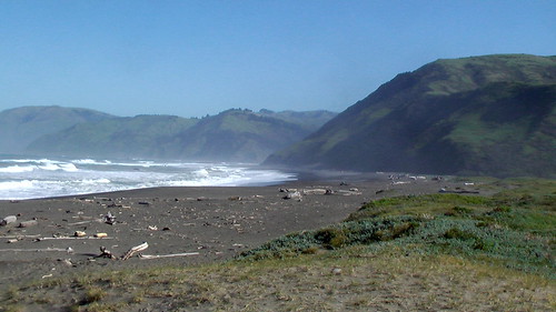
Within minutes I was enjoying the tranquil California coast.

hiking the Lost Coast Trail, California

Minutes after that I was questioning my tolerance for hours of trudging in the sand.

Rick hiking the Lost Coast Trail, California

Happily, there are often bypass trails higher up on the bluff. I walked a combination of beach and trail.

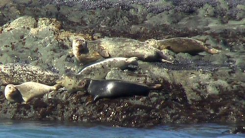
There is a lot of bird and sea life. I saw no sign of the world’s smartest bears while I was there. Bear vaults are mandatory.

hiking the Lost Coast Trail, California

The biggest “challenge” are the creek crossings. I brought a second pair of shoes for water but, in the end, did not use them. On some I simply tramped through. On others I went bare foot.

hiking the Lost Coast Trail, California

This ship must not have seen the Punta Gorda lighthouse.

hiking the Lost Coast Trail, California

About 3.5mi into the morning I spotted a fantastic campsite just being vacated by other hikers. I grabbed it.

hiking the Lost Coast Trail, California

Rick hiking the Lost Coast Trail, California

Paradise.

After establishing my base camp and tying my tent down securely against the North wind, I spent the rest of the day with only a light pack. My turn around time was 3:30PM.

Rick hiking the Lost Coast Trail, California

A gorgeous day on the Lost Coast. I’ll need to hike the south end next time.

hiking the Lost Coast Trail, California

See all 50 of my photos from this hike.

UPDATE from Buzz:

The BLM station at Shelter Cove is easiest info stop. Shuttle service works well tho the tides weren’t right for me to do the Coast in a day using the Shuttle, so I contrived a great loop starting at the S end. Ran up the fire roads and trails to the top of King Peak – highest in the range, old fire lookout, incredible views – then cranked down to the beach where strangely, someone owns a remarkable house accessible only by boat or small plane. Single bottle fanny pack was fine – all the water is drinkable.

related:

• GORP – Lost Coast Romance

Gear Junkie at Everest Base Camp

STEPHEN REGENOLD is on drugs.

… Acetazolamide. That’s what’s written on the bottle. Diamox is its more common commercial name, and because of its aid in acclimatization, the medication is among the most popular with trekkers and climbers in the Khumbu Region of Nepal.

In two weeks, I have come from Minneapolis to Mount Everest, from about 1,000 feet above sea level at home to the thin air of Base Camp. I pushed one day higher still to 18,600 feet, ascending a small peak near Everest (Kala Patthar) for a view of Mount Pumori and the stark black pyramid of Everest itself, an angle of rock piercing to 29,035 feet in the sky. …

click through to read about his trek – Thin Air: Essay on Everest Base Camp

I’m still waiting on a summary report from Kraig Becker, the Adventure Blogger, who was there about the same time.

KFC – Quadruple Down sandwich

I couldn’t resist.

… two thick and juicy boneless white meat chicken filets (Original Recipe® or Grilled), two pieces of bacon, two melted slices of Monterey Jack and pepper jack cheese and Colonel’s Sauce. …

It’s as disgustingly delicious as it looks!

… the sodium content is high — a whopping 1,380 milligrams — more than a half-teaspoon’s worth of salt. For comparison’s sake, the American Heart Association recommends people eat less than 1,500 mg of sodium in an entire day.

Considering the rising consciousness on healthy eating — from rules that will require calorie counts on menus nationwide to Jamie Oliver teaching kids in West Virginia to make better food choices — it was pretty gutsy of KFC to market a product that sandwiches bacon and mayo-based sauce between two pieces of fried chicken.

Still, KFC’s new creation might surprise you a little on the nutritional front. At 540 calories, the Double Down, though not exactly a dieting food, is 90 calories lighter than McDonald’s Premium Crispy Chicken Club Sandwich. …

NPR – The Nutritional Lowdown On KFC’s Double Down


UPDATE – Is it really 540 calories? Or more like 1190 calories?

This crime against humanity will not be sold in Canada. America’s rank as the most obese major nation is safe, for now.

And just in case Wendy’s wants to challenge, KFC has this “sandwich” in the lab …

(via This is why you’re Fat)

You could eat one Quadruple Down, … then set out hiking for the weekend without needing to carry any more food.

the “PCT Method” – hanging a bear bag

Affectionately known by the lightweight hiking underground as the “PCT Method” (presumably because it was first used by long distance hikers on the Pacific Crest Trail), a bear bag hanging method exists that is lighter, requires less rope, offers the benefits of counterbalancing, is easier to set up, and offers simple and quick hanging and retrieval of your food.

Click PLAY or watch and comment on TheBackpacker.tv.

You can make your own system quite easily by assembling the following components:

* Food storage bag
* 40 feet of hanging rope
* Keychain carabiner
* Small stuff sack for a rock (”rock sack”)
* Pencil-sized twig about 4-6 inches long.

I particularly like the second option shown by Bryan DeLay. Many’s the time I’ve needed that in the past.

hiking out of Needles, California

trip report by site editor, Rick McCharles

I awoke early and drove out of town about 10min towards Lake Haversu City.

This geology looked, from the highway, very interesting.

hiking near Needles, California

It’s easy to hike anywhere you wish here. Simply follow the jeep tracks and dry arroyos.

hiking near Needles, California

hiking near Needles, California

This was not an official hiking trail, but made for a very pleasant morning, none the less.

Here’s the view looking back towards Needles.

hiking near Needles, California