In Sudbury, Ontario.
see more – Western Hunter


Thanks Mom.

Best hikes, treks, tramps in the world.
A new blog, HIKING SALT LAKE, has a great, modern look and feel.
The editor, Jonathan Wood, got lost in the Oquirrh Mountains, quite an ordeal.
Three weeks later he returned to the same area, to prove he’s up to the big scrambles in that area. The only one he could convince to come along was his dog, Suki.
I planned to do a few things different from last time. First, I would hit a different peak, Kelsey Peak, which is right next to the one I hit before but maybe a hundred feet higher (it’s one of the highest peaks in the Oquirrh Mountains). Second, I would park closer the trail so I didn’t waste time walking before starting the climb. And, third, I wasn’t going to get lost! …

to see if he and Suki made it down, read on … Kelsey Peak, Butterfield Canyon
by site editor Rick McCharles
Day 2 of my last ditch attempt to complete the Triple Crown of hikes in Waterton National Park.
(If you missed it, click back to Day 1.)
I’d have to complete Akamina Ridge first, then go back to finish Alderson-Carthew:
Akamina Ridge is a round trip hike of about 20km and the maximum elevation is 8600ft. A lollypop loop trail.
Your journey starts at the Akamina Pass trailhead about 1km from Cameron Lake along the Akamina Parkway. The trail starts out on a gentle slope. About 2km in you enter Akamina-Kishinena Provincial Park, shortly after this point and once you have taken the necessary pictures at the “Welcome to BC” sign …

… you will have the options to go to either Forum Lake or Wall Lake to continue your hike. The Ridge is accessible from both but the difficulty upwards vary. This is where the trail really begins. The choice varies from the constant but relatively steady uphill trail to and from Forum Lake or the gentle long trail to Wall lake and then the sudden steep rise all the way up to the trail. …
To save time I tented on the trail.

Like most other hikers, I chose to climb up the Forum Lake trail to access the ridge, descending to Wall Lake. That’s safer I was advised at the Park information centre.
Here’s Forum.

The ridge was signed. No problem.
… until I got to the final scree approach. The trail was covered with wind swept snow. I literally had no idea how to get on top of the ridge, having never done this hike before.
Blast!
Instead I made a frantic scramble back down the mountain to Wall Lake, thinking I would reverse direction, if possible.
That turned out to be a mistake. Time consuming and somewhat dangerous.
I was quite relieved to get to the bottom without injury.

And I’d run out of time.
I dropped a Summit Stone at this cairne, far side of the lake.

And turned back.
My Triple Crown attempt for 2010 was over.

Too bad.
Next year.
This is the 5th year that the Banff Mountain Film Festival has sent a mini-festival of their best climbing films on the road.
Click PLAY or watch the extreme trailer on YouTube.
Ueli Steck, Paul Robinson, Daniel Woods, Lisa Rands, Dean Potter, Peter Croft, Chris Sharma, Cedar Wright, …
official home page
When I scrambled the 15th highest mountain in Colorado in August, I was surprised at how DANGEROUS it is:
… It gets hairy, quickly. Exposure. Potential rockfall. … Many have been killed on this mountain.
I slipped badly on black ice here, the rock still frozen. …
In fact, I slipped badly just past the Keyhole. (The sun had not reached the other side.)

According to the National Park Service:
A hiker along the Keyhole Route of Longs Peak has been killed in a fall of about 300 feet …
The was at least the third fatality on Longs Peak this summer, and the second that occurred near the Keyhole …
As selected by Stephen Regenold, the Gear Junkie:
1. Half Dome’s Cable Route, Yosemite National Park
2. West Coast Trail, Vancouver Island, Canada
3. Mount Huashan Trail, China
4. Rover’s Run, Anchorage, Alaska
5. El Caminito del Rey, Spain
6. Devils Path, NY
7. Peekaboo Gulch, Utah
8. Kalalau Trail, Kauai
9. Pacaya Volcano, Guatemala
10. Kokoda Track, Papua New Guinea
Travel & Leisure – World’s Scariest Hikes
(Thanks for the link HikingintheSmokys.com)
humerous trip report by site editor Rick McCharles
An attempt to be funny:
My original plan was 45km (27.4mi) return to the Glacier. And perhaps on to the Observation Mountain lookout, camping one night at Canada Creek.
I’d read the official Parks Canada description – A’äy (SLIM’S) WEST TRAIL & ROUTE
Arriving at the Tachàl Dhäl (Tachal Dhal) Information Centre, I was surprised to find it already locked up for the season. Nobody in Whitehorse had warned me about that.
Never mind. … Who needs to get updated on local conditions before setting out on a multi-day hike?
Check the trailhead map. And GO.

Amazing. A super highway through the mountains to the toe of Kaskawulsh Glacier. The elevation gain is less than 100m over 22km.
Within an hour I came upon this memorial to a hiker killed by Grizzly in 1996.

Why didn’t someone warn me there were Grizzlies in Kluane National Park?
… Aren’t the males hungry for a meat feed just before hibernation?
Oops. All this flat tundra is pretty soupy. This was the only boardwalk across the marsh.

Why didn’t someone warn me to bring a second pair of footwear for water?
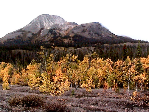
The Autumn scenery was other worldly. I felt lucky to be there on Sept. 11th.

A few hours in I ran into this river crossing:

In the Fall water levels should be very low. … Right?
I backtracked to a ridge and relaxed watching 3 other hikers try to find the best place to cross.

Eventually (tiring of that entertainment) I set up my tent and took an afternoon nap in the bright sunshine.

My Slim’s River hike was over. I wouldn’t make it to the Kaskawulsh Glacier.
Next day I returned to my vehicle early, on to more Yukon adventures.
more photos – hiking Slim’s River West, Yukon (A’äy Chù)
Sunday, Sept 5th Andrew Skurka completed 4,700mi in 7 months via skis, foot, and a packraft.
Congratulations.

CheapTents.com: What part of the Alaska-Yukon route provided the most spectacular scenery?
AS: The Alaska Range was the most majestic, and my route through it was spectacular. The Chugach Range is equally impressive but my route was further away from it. The Brooks Range is a backpackers’ dream, especially Gates of the Arctic National Park in the Fall.
read the interview – Adventurer Andrew Skurka on his latest expedition
(via The Adventure Blog)
New Zealand Track Profiles (NZTP)
Outdoor route planning made easy
New Zealand Track Profiles (NZTP) provides a comprehensive solution to route planning for the New Zealand outdoors:
Elevation profiles for ALL walking tracks in New ZealandHigh resolution 3D topography covering the WHOLE of New Zealand with all the essential details and features normally found only in printed maps. Each map sheet has equivalent area coverage as the corresponding commercial paper map.
Comprehensive track statistics which describe the characteristics of each track and its level of difficulty.
Navigation aids in the form of GPS and Google Earth files, for each track in the map sheet.
Each map sheet is available as a set of two ZIP files which can be downloaded independently.
Some of the 12,000 tracks are free. The rest cost a maximum of $2. … Cheap.
I’m thinking of returning to New Zealand for hiking next year. It’s our #1 hiking destination in the world.
Richard Tulloch’s amusing summary of his early season trek on one of the very best hikes in the world.
The full circuit of Europe’s highest range is some 170km long and takes about 60 hours of walking. Most people do it in 8-12 days. ….
It’s staggeringly beautiful terrain – or is that my pack making me stagger? …
Doing it in June is risky:
… We’re in a bit of trouble on our hike, high on Switzerland’s Col d’Emaney. It’s blowing a gale and there’s frozen snow on a treacherously steep slope. My Dutch companions are carrying ice axes, but I’m not roping myself to anyone who learned their mountaineering below sea level in Amsterdam. …

Click through to see how they got out of this situation …
TOUR DE MONT BLANC – the Swiss section
And while you’re there, click through on HIKING for Richard’s adventures in New Zealand, Australia, Europe and more.
→ besthike TMB information page
