hiking White Sands National Monument

New Mexico

trip report by site editor Rick McCharles

Length: 2 miles (3.5 km), round-trip

The White Sands National Monument … at an elevation of 4,235 feet (1,291 m). …

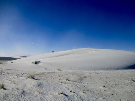
It is the largest gypsum dune field in the world. …

The Monument is completely surrounded by military installations (White Sands Missile Range and Holloman Air Force Base) and has always had an uneasy relationship with the military …

Located on the northernmost boundaries of White Sands Missile Range, the Trinity Site can be found, where the first atom bomb was detonated. …

img_3676
Backcountry Camping Trail map

There are non-stop warnings about dehydration.

img_3679

Let’s go.

img_3681

I wore these lightweight camp shoes. They turned out to be perfect for the soft sand.

img_3682

It was VERY windy.

img_3683

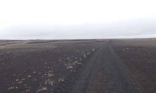
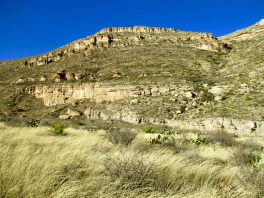
Deserts are always interesting.

img_3685 img_3684

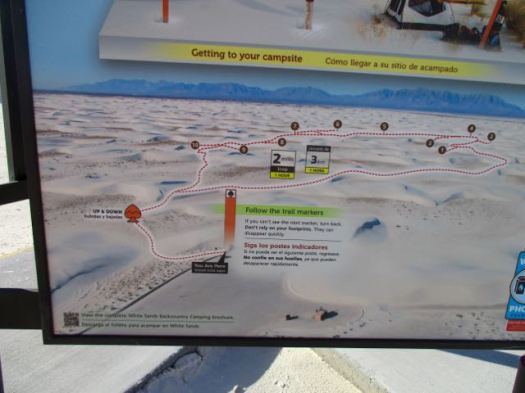
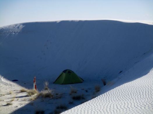
There are 10 backcountry campsites available.

img_3688

details on Backcountry Camping

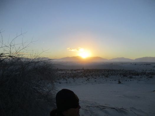
Following my hike, I joined the sunset dunes walk led by a Ranger.

img_3695

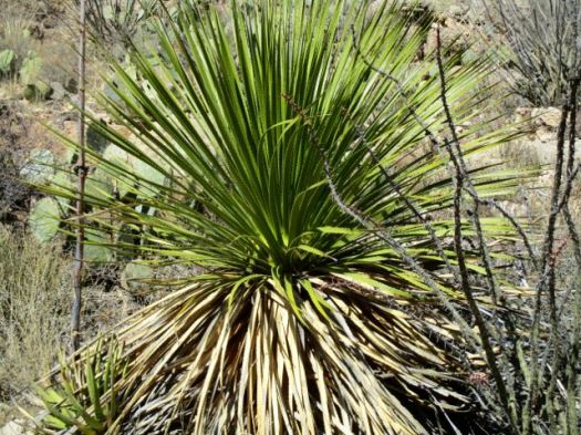
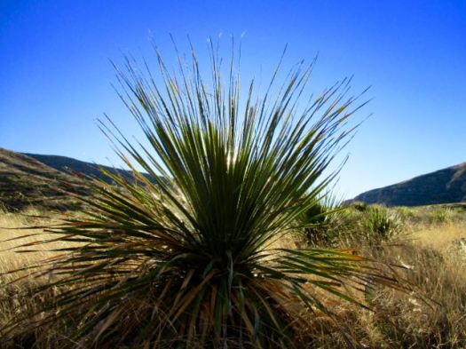
It was very interesting and entertaining. This entire structure was created by that plant.

img_3697

Sunsets are wonderful in the desert.

img_3698

The Ranger noted that any President could remove National Monument status. Potentially this land could be given to the military. 😦

details – Backcountry Camping Trail

There’s a longer (5 mile) Dunes hike called the Alkali Flat Trail. If you want more.

Last Chance Canyon, New Mexico

trip report by site editor Rick McCharles

Story goes that ranchers in 1881 got lost in the deserts. Had no water. With their horses failing they spotted the limestone walls of one more canyon. This would be their last chance.

My guidebook author called this one of my favourite spots in all of New Mexico.

It has plenty of water year round. A rarity in this part of the world.

I started late in the afternoon as it was only 2.7 miles to the recommended campsites.

Last Chance Canyon, New Mexico

The light gorgeous.

Last Chance Canyon, New Mexico Last Chance Canyon, New Mexico Last Chance Canyon, New Mexico Last Chance Canyon, New Mexico

Here’s that water that saved the ranchers.

Last Chance Canyon, New Mexico

Obviously this canyon floods at times.

Last Chance Canyon, New Mexico I checked out the campsites. Too exposed. It was very, very windy.

Instead I hunkered down in this more sheltered spot.

Last Chance Canyon, New Mexico

Having forgotten my bear bag rope, I instead tossed my food bag up into a tree attached to a loose branch. Ingenious improvisation I thought … at the time.

The wind blew it down during the night. Happily my food stayed undisturbed lying on the ground.

Next morning I had the option to try to loop to famed Sitting Bull Falls.

But to save time I opted to backtrack from here, visiting  the falls via the front door.

Sitting Bull Falls, New Mexico

As you probably would guess, the Sioux medicine man Sitting Bull never visited New Mexico.

This is a great hike. Highly recommended. We’ve added it to our list of best hikes in North America.


Rattlesnake Canyon, New Mexico

trip report by site editor Rick McCharles

After visiting Carlsbad Caverns I dayhiked nearby Rattlesnake Canyon.

Rattlesnake Canyon, New Mexico

It’s well loved for Spring wildflowers and a variety of cactus. But I was there in January. Not many flowers.

You immediately drop down into a small drainage following cairns. There’s no signage.

Rattlesnake Canyon, New Mexico

Up the other side the trail is well defined.

Rattlesnake Canyon, New Mexico

Rattlesnake Canyon, New Mexico

I love the desert. And it was a beautiful day … though very windy.

Rattlesnake Canyon, New Mexico Rattlesnake Canyon, New Mexico Rattlesnake Canyon, New Mexico Rattlesnake Canyon, New Mexico

You can go 3 miles out, 3 miles back. Or try to loop via other canyons. Instead I went out about a mile … enjoyed some solitude … then hustled back to my vehicle.

The “unfriendly vegetation” was too often snagging on my favourite hiking pants. It was difficult to avoid.

Rattlesnake Canyon, New Mexico

In the flat desert it’s easy to get lost. Even here close to Carlsbad Caverns and many roads. In 1999 hikers Raffi Kodikian and David Coughlin were lost in Rattlesnake Canyon. Coughlin died.

related – trip report by 160k- Rattlesnake Canyon

The Window, Big Bend TX

trip report by site editor Rick McCharles

Chisos Basin Campground is the best in Big Bend National Park. Reserve in advance as it’s very popular.

The Window, Big Bend

Awaking my first morning I found the famed Window hike ran right past my campsite.

I had two mugs of coffee. Then set off down the trail.

The Window, Big Bend

The Window, Big Bend

The moon still out.

The Window, Big Bend

I was first down the trail this morning. My only company were the large, friendly Mexican jays.

mexican_jay_aphelocoma_wollweberi_3

My first trail in Big Bend, I was impressed with construction and management. Check these stairs cut into stone.

The Window, Big Bend

Here’s the Window pour-off. The only outlet for water from the entire mountain basin.

The Window, Big Bend

Don’t get too close. It’s a 220ft drop to Chihuahuan Desert.

related – Trek Southwest – The Window Trail – Big Bend National Park

Manaslu Circuit – new cantilever trail section

The guided Manaslu Circuit trek in Nepal is one of the very best hikes in the world.

Some good news.

The April 2015 earthquake triggered landslides that destroyed many sections of the Budi Gandaki Trail, cutting off Upper Gorkha, affecting the movement of local people and trekkers on the Manaslu Circuit.

Now, engineers have used cantilever technology to restore damaged sections of the trail along the narrowest and steepest parts of the Budi Gandaki gorge. …

Nepali Times 

manaslu-circuit-bridge-2

manaslu-circuit-bridge

(via Manaslu Circuit Trek)

hiking Big Bend National Park, Texas

I’m planning to hike Big Bend for the first time. In January.

big-bend-park

hiking-big-bend-national-park
The Parks Service recommends:

• Desert Hikes
• Mountain Hikes
• River Hikes

As usual I’ll check with Rangers before deciding which hikes. Local information is critical in the desert. Backcountry Use Permits are required.

I’ll be mostly doing day hikes and one night tenting trips. Water is an issue, I understand, even in winter.

Unless you are walking the Rio Grande, of course.

520px-santa_elena_canyon
Santa Elena Canyon

commercializing Everest’s North Face

A few weeks ago, a Beijing newspaper announced that the Chinese government was building a new mountaineering center and hotel near the north side of Everest. …

The mountaineering center will be located in Old Tingri, a town 40 miles northwest of Everest, and will house much of the infrastructure we currently associate with the French Alps: a heli base for rescue operations on the mountain, a mountaineering school for high altitude workers, and a fully stocked hotel. …

The mountaineering center is scheduled to be completed by 2019, three years ahead of the 2022 Beijing Winter Olympics.

Outside

I hiked Tingri (Dingri) to Everest in 1998. Dingri was one crappy town at that time. Seems it’s not improved much in the years since.

Dingri 2011
Dingri 2011

As always, there will be pros and cons in commercializing Everest in Tibet.

Sherpa – directed by Jennifer Peedom

… charting the disastrous Everest season of 2014. The director aimed to get a Sherpa’s point of view on climbing Everest after the famous flareup of 2013, and instead was on the ground to document the appalling loss of life and resulting Sherpa strike the following year. …

David Lintern

Click PLAY or watch it on YouTube.

Makalu Base Camp trek

Chris Townsend:

This trek to the base of the fifth highest mountain in the world is my favourite of the three treks I’ve done in this part of the world. …

makalu-6

makalu-12

Out There – The Pictures 1: Trekking to Makalu Base Camp

That trek was guided. But you can now do Makalu independently.