hiking Maroon Bells Loop, Colorado

trip report by besthike editor Rick McCharles

• 28mi (45.1km)
• moderate difficulty
• free backcountry permit
• 4 passes all higher than 12,000ft

For years I’ve wanted to get to this, one of the most photographed idyls in the Rockies.

Maroon Lake

The Maroon Bells is a mountain in the Elk Mountains that consists of two peaks, South Maroon Peak and North Maroon Peak, separated by about a third of a mile.

… about 12 miles southwest of Aspen. Both peaks are counted as fourteeners …

The Maroon Bells 4 Pass Loop starts here, high at 9580ft (2920m), mostly above the treeline.

The wildflowers were still quite good mid-August.

Maroon Bells 4 Passes Hike

As usual in late afternoon in the Rockies, weather was iffy.

Maroon Bells 4 Passes Hike

It was an emergency tent site I finally found just at dark. Happily, next morning dawned brilliantly clear:

morning from the tent - Maroon Bells 4 Passes Hike

Early morning I crossed pass #1: West Maroon.

Maroon Bells 4 Passes Hike

En route to Pass #2: Frigid Air:

Maroon Bells 4 Passes Hike

The trails are fantastic, … aside from one much cursed section I called THE QUAGMIRE. Once you reach the biggest waterfall on the Crystal river, the track disappears into a bog of mud and fallen trees.

Who’s responsible?

Here I am cleaning my shoes (deliberately) on a creek crossing.

Maroon Bells 4 Passes Hike

When I met an oncoming hiker who had heard about THE QUAGMIRE, he decided to bushwhack on the opposite side of Crystal river. It couldn’t possibly be worse.

See the next high pass?

Maroon Bells 4 Passes Hike

That’s #3, Trail Rider.

It was a long, exhausting climb. Yet gorgeous.

Maroon Bells 4 Passes Hike

Hikers on Trail Rider pass:

Maroon Bells 4 Passes Hike

The vistas of Snowmass Lake on the other side were all that was keeping me going.

Maroon Bells 4 Passes Hike

Tenting is super popular at Snowmass. I decided to carry on until dusk, approaching the 4th and final pass. …

Next morning I was up at first light, first human at pass #4 Buckskin. It was just me and the mountain goats.

mountain goat - Maroon Bells 4 Passes Hike

I’ll always remember the big open vistas of the Maroon Bells. And the wildflowers.

Maroon Bells 4 Passes Hike

Highly recommended. One of the best hikes in the world.

Rick at Maroon Lake, Colorado

see the rest of my photos

Beartooth High Lakes, Wyoming

trip report by site editor Rick McCharles

35mi (57km) on the Continental Divide

This lollypop loop circuit, as recommended by Lonely Planet Hiking in the USA, starts and (supposedly) finishes at the Island Lake trailhead on the intensely scenic Beartooth Highway, an access to Yellowstone National Park.

The wildflowers here in early August are insanely great.

Unfortunately, the horseflies and mosquitoes are insanely awful. Fish food, I guess.

For all the wildlife in nearby Yellowstone, I was surprised to see nothing larger than this marmot. … Perhaps the mosquitoes drove them out.

The High Lakes hike is aptly named. You trek from one remote lake to the next. With all the granite, at times it reminded me of the Sierra Nevada.

You are going to get your feet wet, for sure. But normally there is a way across the widest streams.

Many love this wilderness for the remote tenting options. Set up wherever you want.

Lonely Planet rates this adventure easy-medium, the worse misranking of any hike in the book. It is correct here:

… Waymarkings and signposts are unreliable. …

The Beartooth High Lakes circuit is very challenging due to the many rocky and wet scrambles. The snow that stays into late July. The lack of signage. Trails that often fizzle out completely.

In fact, I’d not recommend you try it without a good topo and GPS. One lake looks like the next up here.

Here I am wandering out through charming alpine meadows, looking for a good spot to leave a Summit Stone.

Though I was blissfully unaware at the time, I was far lost.

I ended up at the Clay Butte lookout tower, miles from my vehicle. … It was a long highway walk back to my car.

I loved the High Lakes hike. But I’d never do it again until after the mosquitoes are mostly gone. Perhaps September.

The best day hike is the section up to Becker or even Albino lakes.

See all photos from my High Lakes hike.

hiking Boardman Park, Oregon

trip report by site editor Rick McCharles

Astonishingly, Oregon has kept it’s coastline mostly undeveloped.

… 1967’s Oregon Beach Bill allows free beach access to everyone. This Bill allows private beach landowners to retain certain beach land rights, but it removes the property tax obligation of the beach landowner. In exchange, the beach landowner grants an easement passage to pedestrians. …

Wikipedia

But where’s the best place to hike that pristine coast?

hiking Boardman State Park, Oregon

For some reason the authors of Lonely Planet HIking USA directed me to Samuel H. Boardman State Scenic Corridor, close to the California border:

Dramatic sea-stacks, arches and offshore islands seen on this short, down-and-back day hike … are one of Oregon’s best kept secrets …

5.4mi (8.87km)

I drove to the Arch Rock trailhead, locking up my mountain bike to a railing. …


larger map (PDF)

… Then drove to the Natural Bridges trailhead to start the hike.

It is gorgeous. Here are a couple of the many “natural bridges”.

Natural Bridges Cove - Boardman State Park, Oregon

hiking Boardman State Park, Oregon

This “hike” is a series of steeply dropping trails that then backtrack up to the highway. You might drop down to see a secluded beach …

hiking Boardman State Park, Oregon

… or a minor waterfall.

waterfall - Boardman State Park, Oregon

The lush vegetation I liked.

hiking Boardman State Park, Oregon

But the trail itself sometimes returns all the way to paved highway! Dislike.

hiking Boardman State Park, Oregon

I’d not call this a best hike. For once Lonely Planet gets it wrong.

The strategy for Boardman is to drive (or cycle) to each trailhead in series. Then hike down and back each.

I’m still looking for the best long section of the mythical Oregon Coast Trail. Leave a comment if you have advice.

hiking the Grand Canyon is EASY

trip report by site editor Rick McCharles

The most popular overnight hikes in the Grand Canyon require a permit for the Bright Angel campground.

I didn’t have one. You need reserve 4 months in advance!

So first stop was the National Park South Rim Backcountry Office.

Rick at the Grand Canyon

Here I got a number (#4), some paperwork, and instructions to be standing in front of the door next morning when it opened at 8AM.

Happily that worked. I snagged a last-minute camping permit for departure the following day. Of the 3 buses to the Kaibab trailhead, I took the latest, 7AM.

My plan: descend the Kaibab Trail, camp one night, ascend the Bright Angel Trail. That would bring me back to my parked vehicle.

Here we are at the South Kaibab Rim Trailhead 7:30AM.

hiking the Grand Canyon

It’s a Switchback marathon, but worth it, I thought, as the trail follows a ridge crest right to the bottom. Great views!

hiking the Grand Canyon

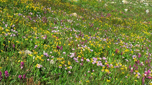
I was there in early May, wildflowers a definite highlight.

hiking the Grand Canyon

hiking the Grand Canyon

It was an easy 2hr descent to the river. Why does my guidebook call it 5-6 1/2 hours?

hiking the Grand Canyon

By 11AM I was in my tent. Siesta time.

hiking the Grand Canyon

At Noon I headed over to the nearby Phantom Ranch. Ordered a coffee and read a picture book on the reintroduction of the California Condor. A success story, so far.

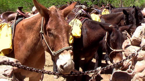
These locals didn’t have much to say. They stood in the sun, silent.

hiking the Grand Canyon

The most exciting animal I saw was a bushy tailed fox, slinking through Phantom Ranch at dusk. His regular route, I was told.

Already feeling some kind of a wimp, finished hiking so early in the day. I felt even worse after talking to this character.

hiking the Grand Canyon

On an 800mi Arizona Trail bike race, he’d been required to carry the bike through the National Park.

What to do with the rest of my afternoon? …

I was tempted to dash up to the North rim and back with just a day pack. But one toe had taken some damage, jammed into the front of my shoe on the descent.

Instead I did a short, intensely scenic day hike, a loop around the two bridges.

I had time to stop and smell the flowers.

hiking the Grand Canyon

hiking the Grand Canyon

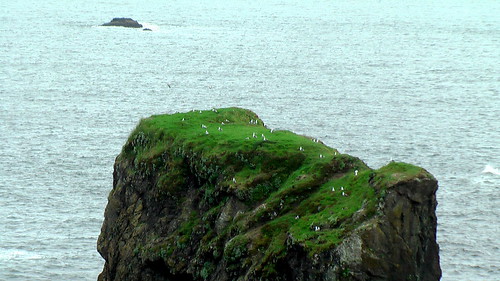
I spent a fair bit of time waiting on one of the passing rafts to overturn.

hiking the Grand Canyon

No luck.

After having lunch with these Mulies, I entrusted them with a secret. …

hiking the Grand Canyon

It had amused me to place a Summit Stone conspicuously under the Bright Angel bridge. The anti-summit, the very lowest point on my rim-to-rim hike.

Next morning I left in no hurry. The Bright Angel Trail is much easier than Kaibab South, though longer.

hiking the Grand Canyon

It’s green. And lush, in the Spring. With plenty of shade and water.

hiking the Grand Canyon

Again I felt personally lazy … after watching these trail runners buzz by.

trail runners in the Grand Canyon

Marathon runner Margaret Bradley died doing exactly the same thing in 2004, but on a lesser used trail. It was July, not May.

In fact, a number of people die in the Grand Canyon every year. If worried, stay home, and read Over the Edge: Death in Grand Canyon, instead.

Mine was a wonderful hike, my first in the Grand Canyon.

Next time I’ll do something much more challenging
. Perhaps rim-to-rim in one day, taking the shuttle back to my vehicle. No permit required.

But I won’t hike in Summer. No way. I don’t want to collapse like George Novak did. That would be embarrassing. My reputation as a best hiker would be ended.

See the rest of my photos from this 2-day hike.

Lower Muley Twist Canyon, Utah

trip report by site editor Rick McCharles

My best hike so far on this Southwest U.S.A. road trip was a little visited slot canyon in Capitol Reef National Park.

It’s now high on our list of the best hikes in North America.

Over a 24hr period I saw no hikers, nor did I see any motor vehicles while tenting at nearby Cedar Mesa campground. The trailhead register showed one or two hiking groups a day, on average.

… a deep, narrow, twisting canyon with large alcoves. The canyon offers many opportunities for side trips and exploring.

From 1881 to 1884, the canyon served as a wagon route for Mormon pioneers traveling south toward San Juan County. The canyon was thought to be narrow enough to “twist a mule” hence the name Muley Twist. The Post cutoff trail is marked with rock cairns and signs, but carrying a topographic map is recommended. It is extremely hot in summer and water sources are unreliable; carry adequate water. Use caution in narrow canyons particularly during flash flood season (typically July-September). …

Best season for hike: Spring and Fall

NPS

The first decision to make is trailhead. I chose the Post parking area. That makes for a perfect “loop” hike of about 15mi.

hiking Lower Muley Twist Canyon

The trail into the wilderness is well marked.

hiking Lower Muley Twist Canyon

Looking back one last time at my vehicle. Would I be lost in the canyons, never to return?

hiking Lower Muley Twist Canyon

Actually, I did not get lost. (much)

Stone cairns led me to the signed intersection with the main canyon trail. If confused, you could always ask one of the locals.

hiking Lower Muley Twist Canyon

Wildflowers are a good reason to hike the desert in the Spring. They were fantastic when I was there.

hiking Lower Muley Twist Canyon

hiking Lower Muley Twist Canyon

But the main attraction of Muley are the massive rock alcoves, as impressive as any I’ve seen anywhere.

hiking Lower Muley Twist Canyon

hiking Lower Muley Twist Canyon

hiking Lower Muley Twist Canyon

You can’t help but wonder how this tiny stream could have carved them.

There is enough water to support some BIG trees.

hiking Lower Muley Twist Canyon

Here’s where the canyon finally narrows enough to “twist a mule”.

Exiting the “narrows”, you should immediately scramble left out of the canyon. I missed it, wandering further.

Checking my Lonely Planet Hiking USA guidebook, I had to backtrack to continue the loop back to my vehicle.

The final section out in the open is much different, but still interesting …

hiking Lower Muley Twist Canyon

… and colourful.

hiking Lower Muley Twist Canyon

Next time … Upper Muley Twist Canyon. Or, perhaps a thru hike connecting the two.

See all my photos of Lower Muley Twist Canyon on Flickr.

All in all, I’d call this a perfect hike. Highly recommended, especially if you don’t like crowds.

The Notom to Bullfrog access road is scenic and (normally) quite safe, even for low clearance vehicles. Don’t let access dissuade you from going.

Hole-in-the-Wall Loop, Mojave

Bird and Hike has a succinct webpage:

This easy, 1.5-mile loop trail starts at the Visitor Center, wanders east and south down a sandy wash, heads west around the south side of the Hole-in-the-Wall hills, climbs up through the Hole-in-the-Wall cleft on the Rings Trail, and then follows the road for 0.2 miles back …

Hole-in-the-Wall Loop Trail (4,252 ft)

Almost every tourists stops at Hole-in-the-Wall. But not all are willing to try the assisted scramble.

hiking Hole in the Wall, Mojave National Reserve

hiking Hole in the Wall, Mojave National Reserve

I’d call it a perfect little day hike for a confident walker. The scenery is desert classic.

hiking Hole in the Wall, Mojave National Reserve

hiking Hole in the Wall, Mojave National Reserve

Add on the “Nature Trail” to the campground. Desert vegetation is signed, … all the bushes looking somewhat similar. With unlikely names like: Paper Bag Bush, Hedgehog Cactus, Horsebrush, etc.

Tent caterpillars were everywhere when I was there.

caterpillars, Mojave

Mojave National Preserve, at 1.6 million acres, is the third largest National Park Service managed area in the Lower 48; only Death Valley and Yellowstone are larger. …

It’s so close to Vegas, I’m surprised more tourists don’t visit. There’s no Park entrance fee. And “wild camping” is allowed almost everywhere.

Teutonia Peak, Mojave

trip report by site editor Rick McCharles

Only 2 hikes in Mojave National Preserve are recommended by Moon Hiking California:

Kelso Dunes
• Teutonia Peak

In the morning I did the Dunes. Then drove on to do a climb. A great hiking day in the desert.

Teutonia Peak, Mojave

Teutonia Peak, Mojave

The highlight for me were the Joshua Trees, but a different species than those in Joshua Tree National Park.

Teutonia Peak, Mojave

At 5,755 feet, Teutonia Peak offers great views of Cima and the surroundings. This four mile round-trip trail heads south from Cima Road and crosses the desert through part of the world’s largest Joshua tree forest. A half mile from the summit the ascent becomes more earnest as the maintained single track now tackles the bulk of the 700 feet in elevation between the trailhead and the peak.

Despite the minimal effort, the views from the top are splendid. …

read more – Hike Speak

Teutonia Peak, Mojave

Actually, to “summit” Teutonia is a class 3 scramble. Most people don’t do it.

No fees. No hassles. You can tent free nearly anywhere. Mojave National Preserve is a great destination for hikers.

see all my photos from this short day hike

Boy Scout Tree Trail, California

trip report by besthike editor Rick McCharles

One thing I love about Tom Stienstra‘s Moon Hiking California guidebook is his list of “best ____ hikes”.

Why doesn’t every hiking guidebook have a list of best hikes?

I wanted a recommendation for a giant Redwood hike and was impressed to find that Tom picked the Boy Scout Tree Trail over the more famous Stout Grove Trail, next door.

hiking Boy Scout Tree Trail, California

Tom Stienstra:

“This is the kind of place where a nature lover can find religion; where the beauty is pure and untouched. The trail is a soft dirt path — often sprinkled with redwood needles — that allows hikers to penetrate deep into an old-grouth redwood forest, complete with a giant fern understory and high-limbed canopy.”

hiking Boy Scout Tree Trail, California

“… The trail feels wonderfully remote and is one of the most pristine old-growth trails in existence. There are only about three other trails in the world where you can walk through old-growth redwoods for five miles or more without hearing traffic noise or seeing any sign of development. …”

Redwood Hikes

hiking Boy Scout Tree Trail, California

hiking Boy Scout Tree Trail, California

I was happy to meet a father and his young daughter who were on a “big tree” hiking holiday from Washington State. Dad told me that Boy Scout would be their toughest hike, so they did it first.

Here’s the Boy Scout Tree … too huge to capture in a photo.

hiking Boy Scout Tree Trail, California

My best photos, so far this trip, I reckon. Click through to see the rest.

weird, wild Saguaro cactus

I feel lucky to have just finished a driving tour of the exact range of the crazy beautiful Saguaro cactus, definitely one of my favourite flora.

… a large, tree-sized cactus species in the monotypic genus Carnegiea. It is native to the Sonoran Desert in the U.S. state of Arizona, the Mexican state of Sonora, a small part of Baja California in the San Felipe Desert and an extremely small area of California …

Harming a saguaro in any manner, including cactus plugging, is illegal by state law in Arizona, and when houses or highways are built, special permits must be obtained to move or destroy any saguaro affected. …

Wikipedia

more interesting photos tagged Saguaro

Keanae Arboretum, Maui

I’m a sucker for great trees. Botanical gardens.

But I skipped the Garden of Eden ($5 entry) instead walking the nearby Keanae Arboretum (free).

Around half-mile beyond mile marker 16 on the Hana Highway

The Ke‘anae Arboretum lies alongside the Pi‘ina‘au Stream on leveled terraces built hundreds of years ago by Hawaiians for growing taro, a mainstay of their diet. A 0.6 mile paved walkway takes visitors through timber, fruit, and ornamental trees from tropical regions around the world, many of which are marked with name plates. Inside the arboretum you can find some 150 varieties of tropical plants (including taro). This is a great location to see some indigenous flowers and the painted bark eucalyptus trees.

An upper section of the arboretum features plants cultivated by the Hawaiians for food and other uses. This arboretum appears to have undergone a major renovation as of our last visit. The renovation included an expansion on the previous path that now leads into beautiful small taro fields not previously located in the arboretum.

There are no facilities or amenities at this stop. Expect to spend 30 minutes to an hour here.

flower

The Aussie Gum trees were my favourites.

gum-trees

Hawaii-Guide