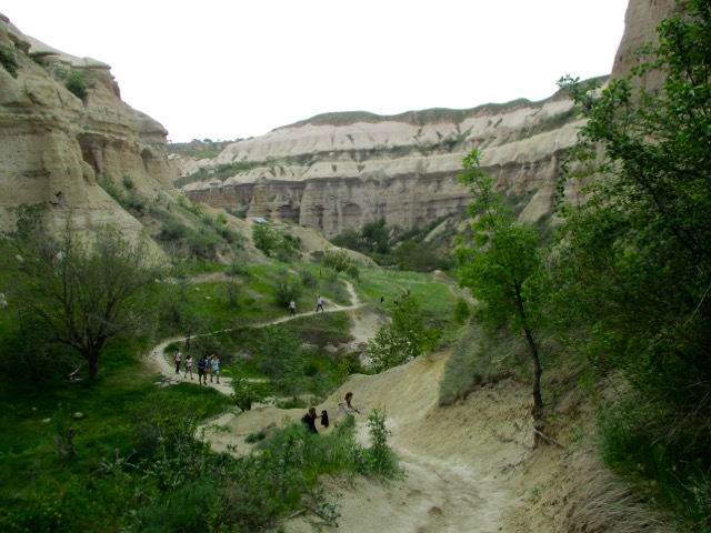
Another misadventure with Mattson and Anderson. 😀
Subscribe to their YouTube channel.
Click PLAY or watch it on YouTube.

Best hikes, treks, tramps in the world.
Another misadventure with Mattson and Anderson. 😀
Subscribe to their YouTube channel.
Click PLAY or watch it on YouTube.
Marc Witkes posting to Inside Outside Magazine on the best trail out of Albuquerque:
And of the many ways to enjoy the Sandias, my favorite is running or hiking up the La Luz trail and taking the Sandia Peak Tramway down.
… The trail begins at 6,559 feet elevation, skirts a residential area for two miles, climbs 800 feet, turns east and descends to the junction of La Luz trail. A “5 mile” sign marks the beginning of a series of 19 switchbacks, many of which are cut through rocky sections made up of layers of shale and limestone. At the Y near the top of the trail, turn right and proceed to the top terminal and High Finance Restaurant (10,378 feet elevation).
While moving up La Luz Trail, you’ll notice dramatically different weather patterns and topographical features. There are four different climatic zones in the Sandias. The Upper Sonoran Zone lies at approximately 5,000 to 7,000 feet elevation, the Transition Zone at 7,000 to 8,000 feet, the Canadian Zone at 8,000 to 10,000 feet and Hudsonian Zone above 10,000 feet. In layman terms, you’ll start in the desert, travel through a wet area and finish in a spectacular alpine setting. Because of these transitional zones, taking off and putting on your jacket, gloves and hat is a common occurrence.
None of this matters that much as you struggle with a shortness of breath while climbing trail sections with a 12-percent grade, but try to pay attention. Juniper, pinion, Gambel and Gray oak, aspen, Douglas and corkback fir, Englemann spruce and limber pine, all quake along the trail. Wildflowers also rage from May to August.
La Luz trail is open year round with the best time to visit in the spring and fall. In summer, temperatures are hot. In winter, you’ll need snowshoes and hiking poles.
If you want to make the trip yourself, click over to Backpacker’s Review for logistics – LA LUZ TRAIL – CIBOLA NATIONAL FOREST (8 MILES)
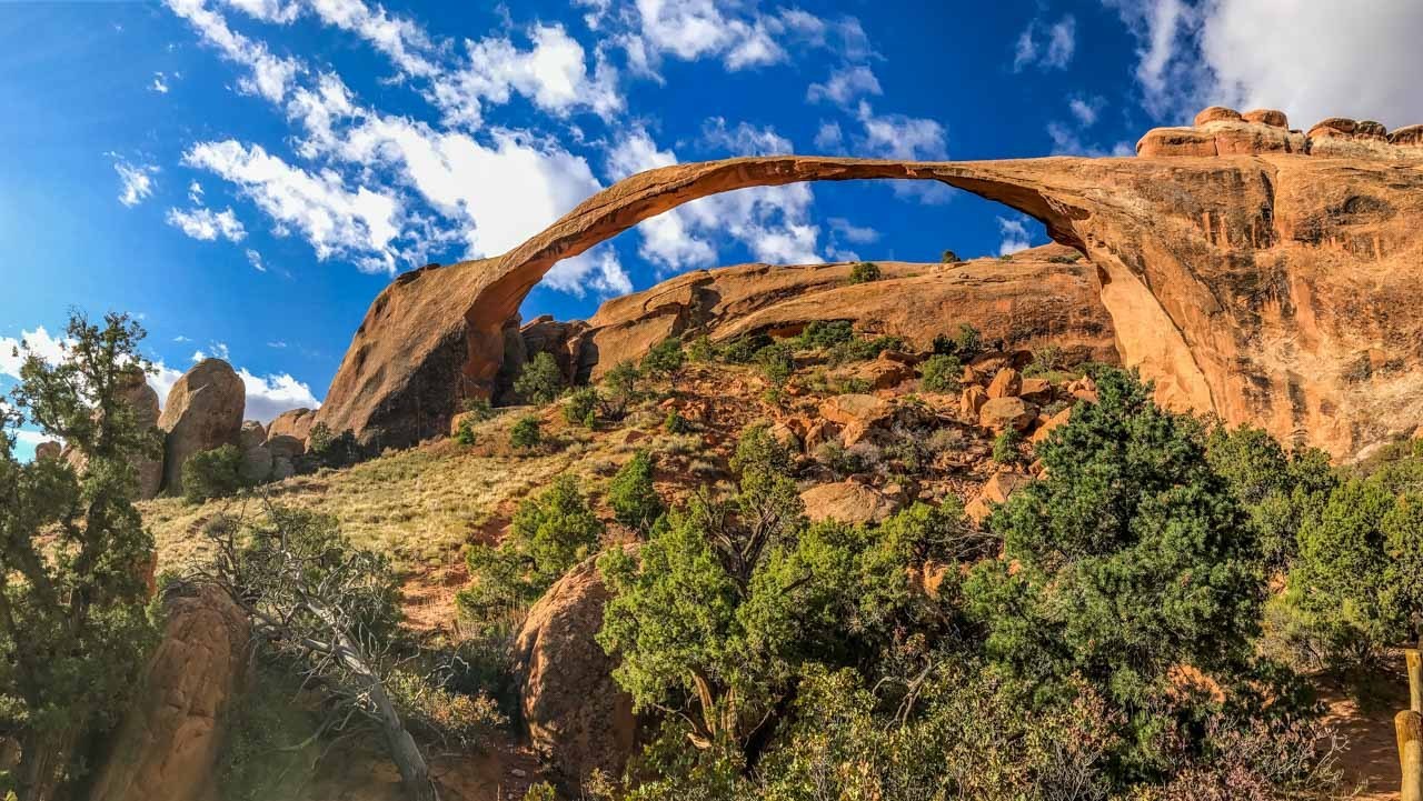
Arches National Park in Utah attracts over one million visitors a year with it’s namesake geologic wonders. …
Hiking the Devil’s Garden Loop is a great way to escape the throngs and see nine aches, including the longest arch in the park.
Easy access out of Moab.
Distance: 7.2 miles
Time: 4-6 hours
Difficulty: Moderate
Elevation gain: 470 ft
Dogs: No
When to go: Year-round
Social Hiker – Hiking the Devil’s Garden Loop in Arches National Park
Marinel Malvar de Jesus is a Filipina American lawyer who decided to leave that world to set up her own trekking company Peak Explorations.
She relocated to Peru. And is currently in Mongolia for the COVID-19 lockdown.
She was there working on a documentary about a group of nomad Kazakh women making a camel trek through the Altai Mountains.
“We Are Nomads is a film about celebrating the relevance and history of women in the adventure and outdoor spaces. …
It will play during a film festival May 30-June 1, 2020.
Click PLAY or watch a trailer on YouTube.
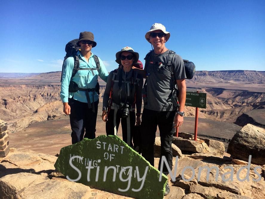
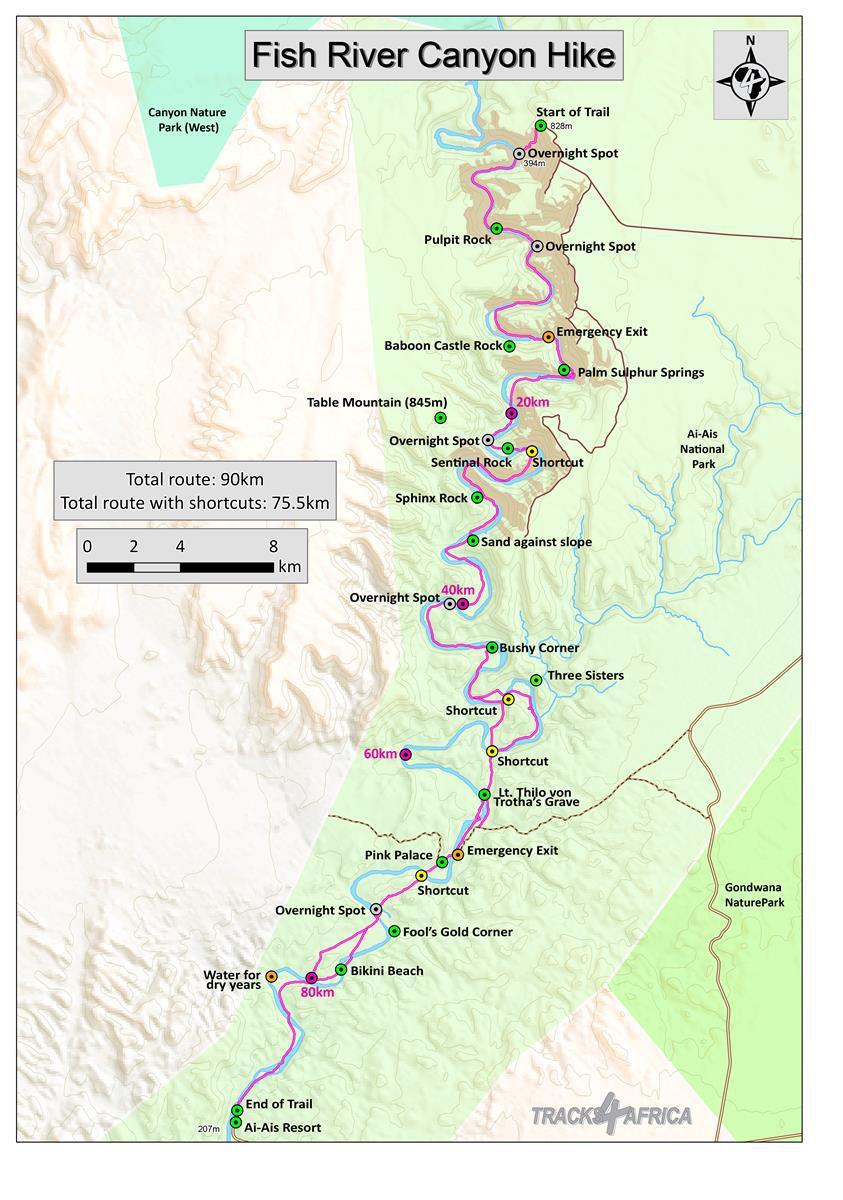
We based our Fish River information page much on Stingy Nomad’s trip report:
Some guide books says this is the toughest hike in Africa …
Fish River is definitely a hike to add to your must do hiking list.
Total distance of Fish River canyon hike 86km, the river itself is longer but due to many shortcuts your walking distance is about 14km less. …
Click PLAY or watch some drone footage on YouTube.
Michael Atkinson places himself in the historic predicament of two stranded German aviators in 1932 to see if the his skills as a survival instructor, pilot and adventurer will allow him to escape to the nearest civilization.
It is a gripping film.
I learned a lot about surviving in the harsh Australian coastal wilderness.
The most remarkable feature of this documentary is its mode of filming. It is not performed by any film crew that follows his journey. It is single-handedly managed by Mike through drones and cameras so it preserves the natural element. The breathtaking pictures of the ocean, varied shades of the waters, flora and fauna of marine sea and the natural cliffs along the coast paint an excellent landscape for the viewers. It manages to take one to an unexplored world …
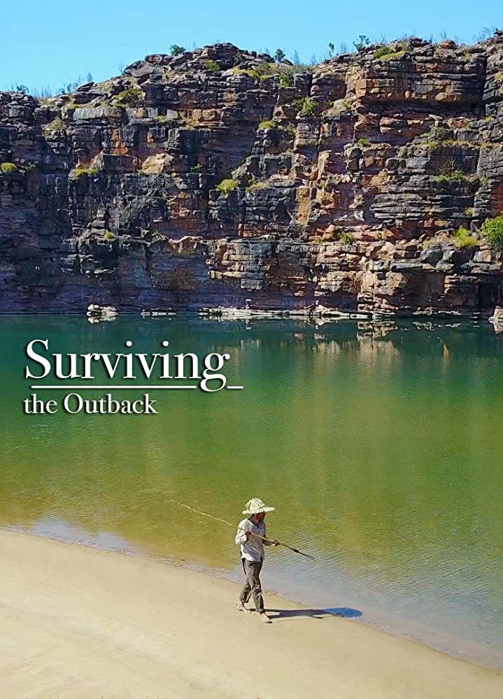
Watch the hour long documentary FREE on TubiTV.
Premiered February 2019.
VERY entertaining.
You might be able to find it on the National Geographic Channel.
In 2016 filmmaker/photographer Pete McBride and writer Kevin Fedarko set out on a 750-mile journey on foot through the entire length of the Grand Canyon.
From the outset, the challenge was far more than they bargained for. More people have stood on the moon than have completed a continuous through hike of the Canyon.
… But their quest was more than just an endurance test – it was also a way to draw attention to the unprecedented threats facing one of our most revered landscapes. …

Uranium mines, tourist development, maintaining indigenous flora and fauna. Native peoples are interviewed thoughout.
Click PLAY or watch the trailer on YouTube.
After half a decade of legislative holdups, New Mexico’s White Sands National Monument has officially been designated a national park. …
The new designation will … have positive impacts on the surrounding community: a 2018 study found that turning monuments to national parks could increase visitation by 21 percent (about 100,000 more visitors) in the first five years and result in a $7.5 million increase in the local economy, mainly due to increased visibility. …
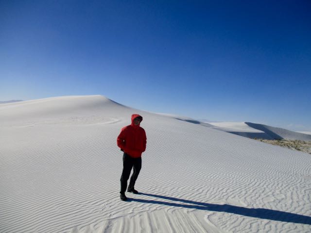
related – hiking White Sands National Monument (2017)
One of our top 10 day hikes in the world.
Only 20 hikers / day are allowed access. The BLM is considering an increase to a maximum of 96 per day .
Getting a permit is the BIG problem.

 on the Utah-Arizona border, halfway between Page, Arizona and Kanab, Utah in the Paria Canyon/Vermilion Cliffs Wilderness
Above and slightly west of the Wave is what many call “the Second Wave“, which has fainter colours but is still of interest to most visitors and photographers.

Check our Wave information page.
For the next 10 days we’ll be rolling out our top 10 day hikes around the world.
Unique walks. Days you’ll remember for the rest of your life.
For example, exploring the “fairy chimney” rock formations of Cappadocia, Turkey. Göreme makes an ideal base.
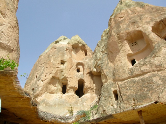
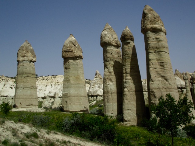
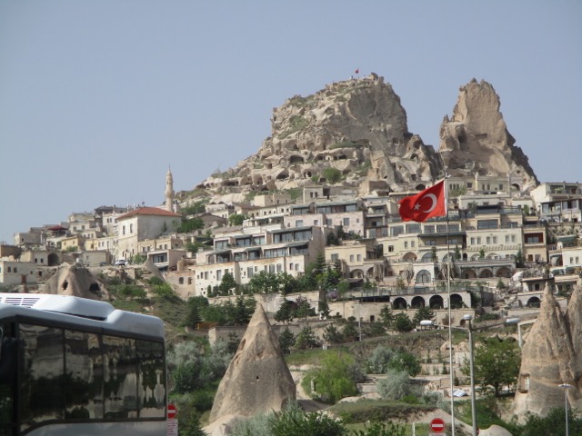
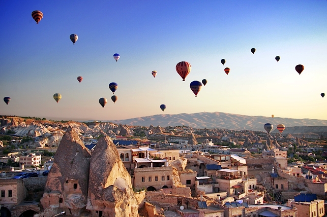
Click over to our Göreme information page for details.

