I’ve many times been asked IF I’d done the Camino. Surprisingly, the answer was NO. Until now. 😀
The Camino de Santiago … known in English as the Way of St James … is a network of pilgrims’ ways or pilgrimages leading to the shrine of the apostle Saint James the Great in the cathedral of Santiago de Compostela in Galicia in northwestern Spain, where tradition holds that the remains of the apostle are buried.
As with most hikes that can be cycled, I prefer to cycle. At least 10% of pilgrims cycle rather than walk or arrive on horseback. They are known as ‘bicigrinos’ or ‘bicigrinas’, bike pilgrims.
My PLAN is to ride León to the famous cathedral. About 325km. Perhaps a week. No rush.
The total length starting in France is 825km.
You need to cycle at least 200km in order to receive a Compostela certificate in Santiago (as opposed to minimum 100km walking).
Nearly 350,000 Compostela pilgrim certificates were issued in 2019. I won’t be lonely. 😀
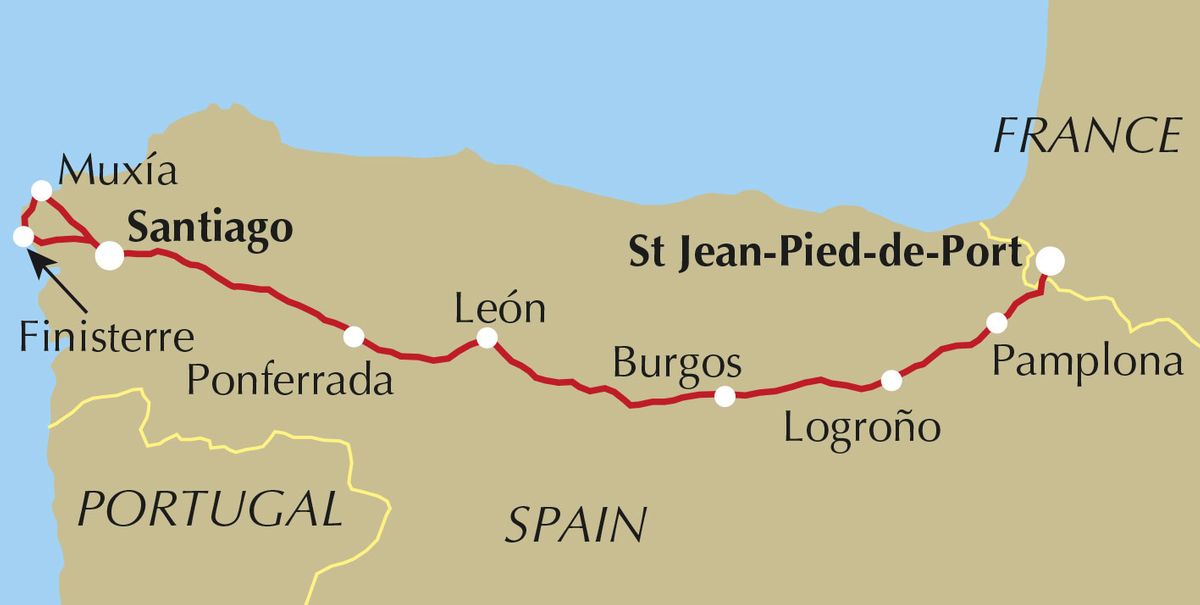
The Camino Francés, or French Way, is by far the most popular of many routes. Roughly 60% of pilgrims choose this camino over other options.
Though no guidebook is needed, I picked up a paper copy of Mike Wells’ Cycling the Camino de Santiago (2019). I’d listened to a good interview with the author.
Wish me luck.
Many folks only know the famous pilgrimage from the 2010 Martin Sheen movie. It’s very good, by the way.
Click PLAY or watch the trailer on YouTube.