This is a bikepacking VIDEO but some of the tips are appropriate for hikers, as well.
Click PLAY or watch it on YouTube.

Best hikes, treks, tramps in the world.
This is a bikepacking VIDEO but some of the tips are appropriate for hikers, as well.
Click PLAY or watch it on YouTube.
At 3 pounds, it’s doubtful I’d carry the Shine ultra-compact wind turbine on a hike.
Cost November 2023 is CAD $400 (US $290).
At this time it’s only available in Canada and the USA.
BUT I’m thinking it might be ideal for bikepacking central Iceland summer 2024.
AND ideal if I were to camp out in one place for a number of days.
Click PLAY or watch it on YouTube.
Indian Himalaya ➙ BUT if you want to argue The Dolomites, we won’t disagree. 😀
India is vibrant, chaotically mad. But you can easily escape to the tranquil high mountains and have them to yourself.
This is Nepal, but without “teahouses” packed together on every popular trail.
Indulge your spirit of adventure and trek the spectacular Indian Himalaya. First-timers and seasoned trekkers alike can experience the region’s rich blend of cultures, religions and dramatic landscapes … LP

As you know, the weather is fickle. The infrastructure undeveloped. You need be confidently independent at altitude or sign on with a reputable guiding company. People die in the Himalaya every year of altitude sickness.
Personally, sadly, I’ve hiked very little in this region. I’m still kicking myself for not trekking to Kangchenjunga when I had the chance in the 1990s. I stood on a ridge in Darjeeling looking at the third highest peak in the world, and decided to head to the beaches of Goa for Christmas, instead. Doh!
The best future destinations for serious hikers, I think, are the Indian Himalaya and Bolivia. (Bhutan, as well, if it ever opens to independent travel.)

More information on our new Indian Himalaya information page.
The best guidebook is Lonely Planet Trekking in the Indian Himalaya. But more inspirational is Trekking and Climbing in the Indian Himalaya (Trekking & Climbing Guides) by Harish Kapadia. (It can be difficult to find a copy.)
Leave a comment if you have your own favourite trek in the Indian Himalayas. We’re looking for advice.
WELCOME.
Stella is a bad ass thru hiker. Plenty of experience.
Former host Eric Hanson is now over on his personal YouTube channel.
Click PLAY or watch Stella on YouTube.
I’m happy my edit shows the MAGIC and CHALLENGES of Iceland’s best volcanic hike in just 4 minutes.
I did it twice in September.
Click PLAY or watch it on YouTube.
A few hours after I posted that video, one of my favourite hiking vloggers — Harmen Hoek — posted his own.
He was there a few weeks before me. In August.
Harmen hiked in the opposite direction. And added the spectacular Fimmvörðuháls hike.
Click PLAY or watch it on YouTube.
My favourite layer for hiking — and almost anything. I wear this jacket most days of the year.
I bought 2 MORE Men’s Helly Hansen LIFALOFT™ Hooded Insulator Jackets.
I fear Helly might stop making them one day.
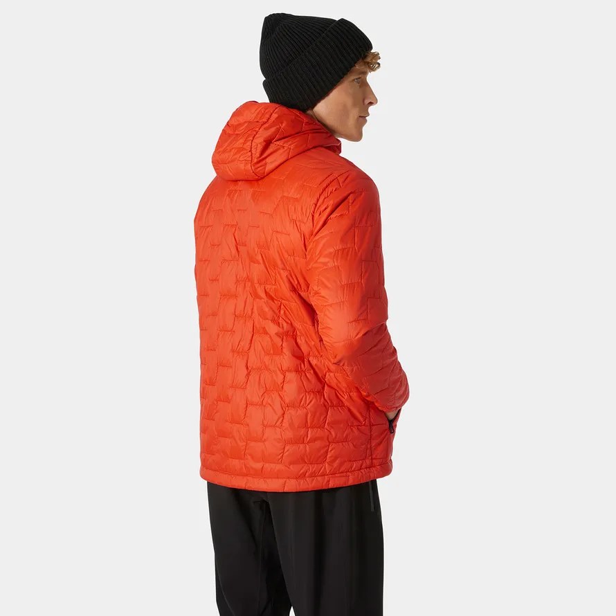
The LIFALOFT™ jackets have been my favourite since 2019 when Kraig Becker sent me one.
LIFALOFT™ is not down. It’s arguably lighter and warmer.
The idea is to trap a maximum amount of air in a small space. And due to the hydrophobic properties of LIFA®, LIFALOFT™ has an inherent water repellency that seems to keep me warm, even when wet.
And I’ve drenched these jackets over the years.
They are light. Durable. Machine washable.
And relatively inexpensive. About half of what I would pay for a Mountain Hardwear Ghost Whisperer/2 Hoody.
I wait all year for the next Banff Festival video.
So skillfully done. So entertaining.
Click PLAY or watch it on YouTube.
I finally got my hands on a copy of Cam’s excellent coffee table book from 2017.
It’s only available in hard copy. Inspirational.
Highly recommended as a gift for a hiker.

It includes 32 of the BEST HIKES from around the world. A quick summary. A starting point for those planning future adventures.
I’ve done all or parts of 19 of those 32 — and found the description very accurate.
The list in this book is a mixed selection of some of Cam’s favourites. It includes thru hikes like the Appalachian Trail and Great Divide Trail. Some classic multi-day hikes like Laugavegur and Walkers Haute Route. And even some shorter walks like Zion Narrows and Tongariro Crossing.
In my opinion, Cam Honan is the greatest hiker of al time. He’s done more of the BEST HIKES in the world than anyone else.
I interviewed him in 2015.
The 2023 Banff Centre Mountain Film and Book Festival is in Banff, Alberta, from October 28 to November 5.
… 84 films from 13 countries.
Online film screenings during the Festival are also back, bringing on-demand films to your homes in Canada/USA from October 28 through November 5, plus some award-winning films online from Nov. 6-8.
Get your tickets for events in Banff or your Online Film Pass today 👉 https://www.banffcentre.ca/film-fest
Click PLAY or watch it on YouTube.

