Rocky Mountain lows …

My hiking buddy, Stanley, dragged his non-hiking wife along this year to wonderous Lake O’Hara in the Canadian Rockies.

In her weekly column, Kate bemoans the prospect:

… for many years, Stanley and a bunch of his old buddies met once every summer in the Rockies for long, full days of tromping uphill in flannel shirts, with gigantic backpacks pulling them in the opposite direction. The highlights, such as they were, seemed to consist of glacier-side “boil-ups” of Sapporo Ichiban and beef jerky washed down with Tang around noon.

Night-time in the mountains apparently fell about 6 p.m., at which point they’d mix some Crystal Lite with rotgut vodka, sit around a campfire, and break wind while tallying up the day’s marmot sightings. …

Funny. Read the rest on Kate of LateNobody sings about the Rocky Mountain lows
… How did the trip go?

Kate looks … happy.

seen the visor buff … ??

Hate hats?

But need to shade your eyes …

What about a Bandana with a visor?

Perfect solution.

Watch a video.

I carry a regular buff but rarely seem to use it. For one thing, it’s shoddy in that only one side is “finished”. … This I might actually use.

(via v-g Backpacking in Britain)

decided – I’ll thru hike Continental Divide Trail, Colorado

by site editor Rick McCharles

I’ve done enough investigation this summer.

My first thru hike will be this:

… The CDT passes through many of the highest and wildest mountain regions of Colorado, such as the San Juan Mountains and the Sawatch Range. …

It is concurrent with the Colorado Trail for approximately 200 miles. The Continental Divide itself in Colorado meanders some 650 miles. There are many stretches of the Continental Divide in Colorado that have no distinct marked or named trail. …

Continental Divide Trail, Colorado

All I need now is TIME one summer. And a solar powered, satellite blogging device.

Advice?

Leave a comment.

NEW New Zealand hiking site

New Zealand Track Profiles (NZTP)

nzTrackProfiles.com

Outdoor route planning made easy

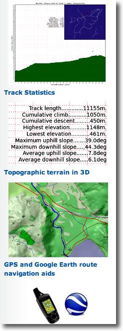
New Zealand Track Profiles (NZTP) provides a comprehensive solution to route planning for the New Zealand outdoors:
Elevation profiles for ALL walking tracks in New Zealand

High resolution 3D topography covering the WHOLE of New Zealand with all the essential details and features normally found only in printed maps. Each map sheet has equivalent area coverage as the corresponding commercial paper map.

Comprehensive track statistics which describe the characteristics of each track and its level of difficulty.

Navigation aids in the form of GPS and Google Earth files, for each track in the map sheet.

Each map sheet is available as a set of two ZIP files which can be downloaded independently.

Some of the 12,000 tracks are free. The rest cost a maximum of $2. … Cheap.

I’m thinking of returning to New Zealand for hiking next year. It’s our #1 hiking destination in the world.

Gary Robbins – records WCT, ECT

The East Coast Trail stretches for 340 miles along the Atlantic coast of Newfoundland, while the West Coast Trail runs for 47 miles along Vancouver’s southwestern shoreline. …

Recently, endurance athlete Gary Robbins set the daunting goal for himself to attain speed records on both of these trails, starting in Vancouver and the WCT on August 4th.

Running North to South, Gary completed the entire 47 miles in just 10 hours and 8 minutes, which does indeed establish a new record for that route. Of course, that was just a warm-up for the much longer, and more challenging ECT, which he began on August 20th and completed on the 22nd, finishing the entire route in a blistering 35 hours and 17 minutes. …

The Adventure Blog – Endurance Athlete Sets Speed Records on Canada’s East and West Coast Trails

hiking Maroon Bells Loop, Colorado

trip report by besthike editor Rick McCharles

• 28mi (45.1km)
• moderate difficulty
• free backcountry permit
• 4 passes all higher than 12,000ft

For years I’ve wanted to get to this, one of the most photographed idyls in the Rockies.

Maroon Lake

The Maroon Bells is a mountain in the Elk Mountains that consists of two peaks, South Maroon Peak and North Maroon Peak, separated by about a third of a mile.

… about 12 miles southwest of Aspen. Both peaks are counted as fourteeners …

The Maroon Bells 4 Pass Loop starts here, high at 9580ft (2920m), mostly above the treeline.

The wildflowers were still quite good mid-August.

Maroon Bells 4 Passes Hike

As usual in late afternoon in the Rockies, weather was iffy.

Maroon Bells 4 Passes Hike

It was an emergency tent site I finally found just at dark. Happily, next morning dawned brilliantly clear:

morning from the tent - Maroon Bells 4 Passes Hike

Early morning I crossed pass #1: West Maroon.

Maroon Bells 4 Passes Hike

En route to Pass #2: Frigid Air:

Maroon Bells 4 Passes Hike

The trails are fantastic, … aside from one much cursed section I called THE QUAGMIRE. Once you reach the biggest waterfall on the Crystal river, the track disappears into a bog of mud and fallen trees.

Who’s responsible?

Here I am cleaning my shoes (deliberately) on a creek crossing.

Maroon Bells 4 Passes Hike

When I met an oncoming hiker who had heard about THE QUAGMIRE, he decided to bushwhack on the opposite side of Crystal river. It couldn’t possibly be worse.

See the next high pass?

Maroon Bells 4 Passes Hike

That’s #3, Trail Rider.

It was a long, exhausting climb. Yet gorgeous.

Maroon Bells 4 Passes Hike

Hikers on Trail Rider pass:

Maroon Bells 4 Passes Hike

The vistas of Snowmass Lake on the other side were all that was keeping me going.

Maroon Bells 4 Passes Hike

Tenting is super popular at Snowmass. I decided to carry on until dusk, approaching the 4th and final pass. …

Next morning I was up at first light, first human at pass #4 Buckskin. It was just me and the mountain goats.

mountain goat - Maroon Bells 4 Passes Hike

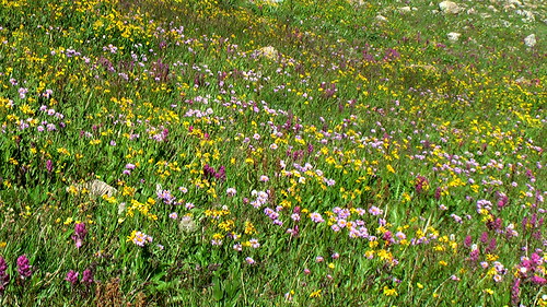
I’ll always remember the big open vistas of the Maroon Bells. And the wildflowers.
Maroon Bells 4 Passes Hike

Highly recommended. One of the best hikes in the world.

Rick at Maroon Lake, Colorado

see the rest of my photos

hiking Crater Lake, Colorado

trip report by besthike editor Rick McCharles

This is Crater Lake Trail #623 in the San Juan National Forest between Silverton and Durango. … Not the more famous (but far less appealing) Crater Lake in the Maroon Bells.

The Crater Lake Trail is an excellent long day hike or overnight that begins at Andrews Lake. Crater Lake is nestled in a basin at the foot of Twilight Peak. This peak and Snowdon Peak are both accessible from the Crater Lake Trail. …

• 5.5mi (8.8km)
• trailhead at 10,800ft
• Crater Lake at 11,600

I had planned to climb Twilight or Snowdon early morning after the night I tented at Crater. But it rained steadily all night. Both peaks were cloud shrouded in the morn. I marched directly out.

another June Tour de Mont Blanc

Richard Tulloch’s amusing summary of his early season trek on one of the very best hikes in the world.

The full circuit of Europe’s highest range is some 170km long and takes about 60 hours of walking. Most people do it in 8-12 days. ….

It’s staggeringly beautiful terrain – or is that my pack making me stagger? …

Doing it in June is risky:

… We’re in a bit of trouble on our hike, high on Switzerland’s Col d’Emaney. It’s blowing a gale and there’s frozen snow on a treacherously steep slope. My Dutch companions are carrying ice axes, but I’m not roping myself to anyone who learned their mountaineering below sea level in Amsterdam. …

Click through to see how they got out of this situation

TOUR DE MONT BLANC – the Swiss section

And while you’re there, click through on HIKING for Richard’s adventures in New Zealand, Australia, Europe and more.

→ besthike TMB information page