The Klondike Road Relay this weekend, about 230km.
… OK, my team is running the distance. My leg is about 14km, at about 5:30AM.
Should I wear the Chicken suit?

After the race I’ll get out for 2-3 days hiking in the Yukon mountains.


Best hikes, treks, tramps in the world.
The Klondike Road Relay this weekend, about 230km.
… OK, my team is running the distance. My leg is about 14km, at about 5:30AM.
Should I wear the Chicken suit?
After the race I’ll get out for 2-3 days hiking in the Yukon mountains.
The Adventure Blogger posted his recent adventures with wolf guru park ranger Rick McIntyre.
And also posted an account on Gadling:
… In 1995, 70 years after the last wolf has been spotted in the park, a controversial plan was announced to reintroduce wolves to Yellowstone. Experts saw them as vital to managing the overall health of the park’s ecosystem, which had seen its elk herds grow to record numbers, unchecked by any natural predators. Meanwhile opponents to the plan feared that the wolves would wander out of the park and once again raid the livestock of ranchers. It turns out both parties were right …
Tracking the various wolf packs of Yellowstone is quite a job, as they are regularly on the move and prefer to stay well hidden from prying eyes. They all have their own territories however, which helps to define their locations to a degree, so if you are traveling through Yellowstone, it is worth the time and effort to see if you can spot them in the wild. Be sure to bring a good pair of binoculars or a spotting scope of your own …
Gadling – Spotting wolves in Yellowstone
Coincidentally, I saw my first wolf there a few days earlier. At night, in the dark, one lingered beside the highway looking at my vehicle before slipping away down slope.
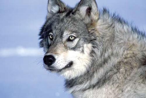
I didn’t have time to get a photo. But I’ll pretend this one is mine:
Andew Skurka is the most accomplished “hiker” of all time.
Andrew’s 6,875-mile Great Western Loop ranks as the #1 thru hike of all time, in my books.
He’s currently doing Alaska / Yukon, 4,700 miles in 7 months via skis, foot, and a packraft.
… Now unknown Samuel H Gardner is setting out in January on a 12,500mi proposed route he calls the “All-In Trek”.
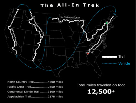
… end-to-end and back-to-back the four longest trails in the U.S. This involves starting the trek on snowshoes on January 1st on the North Country Trail Westbound, then the Pacific Crest Trail Northbound, then the Continental Divide Trail Southbound and finally hiking the Appalachian Trail Southbound. It is my intention to hike the 12,500+ miles continuously in one trip. It is my goal is to finish in one calendar year. However, the four trails have never been hiked back-to-back before so the “journey” is more important to me then the speed record. Simply, I intend on walking quickly to avoid most of the deep snow in the mountains. …
Ambitious, or what?
I’m not sure even Skurka would attempt it.
That comes from an excellent interview on CheapTents.com.
Gardner’s official website is called – the INITIATIVE
(via The Adventure Blog)
Travel writer Julie Blakley posted her favourite hikes on BootsnAll:
• Tongariro Northern Circuit, North Island, New Zealand
• Zion Narrows, Utah, United States
• Annapurna Circuit, Nepal
• Inca Trail, Peru
• Tiger Leaping Gorge, China
• Mount Kiliminjaro, Tanzania
• Kalalau Trail, Kauai, Hawaii
• Torres del Paine Circuit, Chile
• Tour de Mont Blanc, France
• West Coast Trail, British Columbia, Canada
10 Best Hiking Trails in the World
A good list. They’re all on our list of the best hikes in the world. And 4 are on our top 10 hikes anywhere.

… You might be disappointed with Tiger Leaping Gorge and the Inca Trail, though. Over-rated.
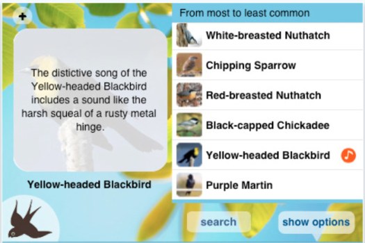
… Tune in to bird songs by training yourself with this free app. Select your region to see the birds that are commonly heard there. You can sort the birds by name, how commonly they are seen, or their song style and listen to each bird’s unique tweets. The app also provides a picture of each bird to make spotting nearby tweeters easier.
You’ve heard it time and time again. Don’t risk buying the shoddy fake gear in Asia.
I ignored that sage advice last November, buying a bag looking somewhat like this one, the Ajungilak Sphere Spring. US$445 on the Marmot website.

My cost … US$76.
I bought it at the best department store in Kathmandu, BhatBhateni Super Store.
When I asked the clerk if it was “made in Nepal“, not in Romania as it claimed on the label, he vigorously denied it was a fake.
About 4 months later, the zipper started to fail. Weeks after that, the seams started to undo. Each morning I’d wake with plenty of goose down floating around my tent.
Finally I replaced it with this GoLite Adrenaline 40°F Down Sleeping Bag – Mummy, 800 Fill Power (For Women) bag from Sierra Trading Post.

I paid $162.50 for it, in store. Same price as on their website today.
I tried the Men’s version, as well. But the Women’s just felt better. And with a half zip it was 1oz lighter. (1 lb. 6 oz. Regular)
At Jackson Hole ski resort in Wyoming it costs $25 to ride the Aerial Tram both ways. But it’s FREE to ride down … if you hike up.
Via the Summit Trail that’s 7.2mi (11.6km)
At the start, I was still super energetic.

I hope this isn’t an old Tram … that fell.

End of August, some of the wildflowers are still hanging on.

Finally, Top of the World:

Other hikers agreed that it’s MUCH more challenging than we expected. The 4,139ft (2600m) elevation gain is compounded by lack of oxygen. Top of the World is 10450ft (3185 m).

I saw no wildlife other than one marmot, and some pikas. A bear was spotted from the Tram earlier in the day.

trip report by site editor Rick McCharles
… Naturalist Basin is a multi-tiered wonderland of lakes and alpine scenery. Nestled between two 12,000+ foot peaks (Agassiz 12,428′ and Spread Eagle 12,540′), in the western end of the main 100 mile Uinta spine, Naturalist Basin is one of the quicker routes to get into the wilderness experience of the Uinta Mountain Range. …
The High Uintas Wilderness near Salt Lake City is convenient for backcountry camping. And horse camping.

Perhaps too convenient:
… extremely popular, over-fishing, destructive camping and too many campfires have taken their toll on some of the purity in the area, but it remains an incredible treasure just the same. The Forest Service has now permanently banned campfires in Naturalist Basin, and has shut down many campsites, especially around the first meadow in Naturalist Basin. …
Of the 545 miles of trail, I decided on the Highline Trail trailhead near Butterfly Lake.
The approach was somewhat dull, actually, tree-locked. The creeks were the highlight.

Here’s why we like it. High alpine meadows.

There are a number of pretty lakes, high up. My map wasn’t detailed enough to name them.

That one might be Blue Lake.
End of August, the summer was clearly dying.

This was as high as I could get without scrambling to one of the summits.

Candice Walsh posted a nice write-up on Go Nomad:
… The trail starts out with overhead views of Quidi Vidi Village and the surrounding cliffs. If you wander close enough to the edge, you can practically dangle your feet down onto tiny, brightly painted fishing sheds huddle against the rock face. The first leg is difficult and almost entirely uphill: steep hills to climb, stairways rising straight upwards, and often high winds to prevent you from moving forward quickly.
But the view at the top? Completely worth it. …
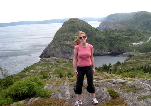
Check it out – Rediscovering Newfoundland and the East Coast Trail
official home page – East Coast Trail
related post – my July 2010 day hike trip report
She likes.
In the Sierra Nevada the Hiking Lady compared USGS topo with Tom Harrison maps and the new National Geographic Trails Software.
… On the trail, I found I much preferred the National Geographic and Tom Harrison maps to the USGS maps. They are well labeled and trail distances are clearly marked. The National Geographic map definitely proved to the best.
Here’s why. After we set up camp near Garnet Lake, the next day we decided to take a look around and head to Thousand Island Lake. Using just the USGS and Tom Harrison maps, we plotted a route up to the saddle to take a look at Thousand Island Lake. However, as you can see in the maps below, the National Geographic map has the additional detail that shows that there is a trail from Garnet Lake to Thousand Island Lake! …

USGS – Garnet Lake Topo

Tom Harrison Map – nice shaded relief, but no trail!

National Geographic Map – the only one that includes the trail!
Additionally, the shading on the map gave me a good perspective on elevation, so I didn’t need to spend so much time counting contour lines!
I am quite impressed with the software program. The cost is $49.95 for the entire Sierra Nevada range (10 map regions), so it is definitely more cost effective than buying each map individually.
Bottom line: The National Geographic Trails Software impressed me, and I will be purchasing it for other region where I hike.
read the review
 besthike.com