TOP 10 day hikes ➙  Laguna de los Tres, Argentina

One of our top 10 day hikes in the world.

Why?

The photos say it all. 😀

  • our pick for best day hike — of many — out of El Chaltén, Argentina’s Trekking Capital in Patagonia
  • the nearest airport is El Calafate
  • November – March are the best months. You might have snow on the trail in November or March, however.
  • 8+ hours round trip depending on route
  • elevation gain 2,300 ft. (700m)
  • option to tent near the lake
  • infamous for bad weather. Be prepared for extreme wind.

World → S AmericaPatagonian Andes → Argentina → Laguna de los Tres

vista from El Chaltén

For details click over to our Laguna de los Tres information page.

10 days Solo – Larapinta Trail, Australia

Laura Waddell had a terrific adventure in May.

The Larapinta Trail is an extended walking track in the Northern Territory of Australia. Its total length covers 223 kilometres (139 mi) from east to west, with the eastern end at Alice Springs and the western end at Mount Sonder, one of the territory’s highest mountains. It follows the West MacDonnell Ranges, sometimes along the ridge line, other times on the plain below, in the West MacDonnell National Park. …

During the summer months, temperatures along the trail can exceed 45 °C (113 °F) leading to risk of heatstroke and dehydration. Most people walk the trail during winter when the days are cooler.

Click PLAY or watch it on YouTube. (25min)

TOP 10 hikes ➙ John Muir Trail, California

John Muir Trail is one of our top 10 hikes in the world.

Click PLAY or watch a 1-minute preview on YouTube.

John Muir Trail

If there’s a hiker’s paradise on earth, it’s the JMT in the Sierra Nevadas.

213 miles without a road. Fantastic weather. 11 high passes. Unbelievable nonstop vistas. And Mt Whitney.

AT A GLANCE

Yosemite map
  • Yosemite, Ansel Adams and John Muir wilderness, Kings Canyon and Sequoia National Parks
  • start in stunning Yosemite, Muir’s “Range of Light”
  • 223mi (360km) to Whitney Portal adding sidetrips to Half Dome, Vermillion Resort and Mt. Whitney 14,505ft (4,421m)
  • 15-21 days recommended
  • carry your own food and tent
  • JMT about 10% the length of the Pacific Crest Trail

Read more on our John Muir Trail information page.

Amazing Stuðlagil Canyon, Iceland

Trip report by BestHike editor Rick McCharles

When the construction of Kárahnjúkar Hydro Dam was finished 2009, Stuðlagil (Studlagil) Canyon became fully visible.

The water level in the river Jökla, that runs through the canyon, dropped and amazing basalt columns have since become one of the most popular tourist attractions in eastern Iceland.

Click PLAY or get a glimpse on YouTube.

The landowners were still building tourist infrastructure in 2024.

I stayed at the simple campground on the northern side of the river.

A German couple — world travellers — in a camper van, offered me lamb dinner with locally picked mushrooms. And wine! It was my best meal in Iceland. 😀

Once the tourists were gone in the evening, I climbed down a long set of stairs to have the northern viewing platform all to myself.

Next morning, I cycled over to the southern side of the river. It’s the better experience. Go to both sides, if you can.

Stuðlagil (Studlagil) is a canyon in the Eastern Region of Iceland.

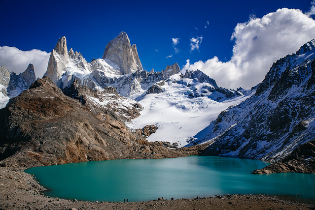
It is known for its unusual amount of large columnar basalt rock formations and the turquoise coloured river that runs through it.

The canyon also has an interesting story as it became an unexpected tourist sensation in 2016 after Einar Páll Svavarsson published an article in August of that year on hiticeland.com with spectacular photos.

A year later Einar also wrote an article about Stuðlagil in WOW air magazine in June 2017 and after that the canyon became a popular tourist destination.

It’s an easy detour off the Highway 1 Ring Road. About a 19km/11.8mi sidetrip along road 923. Mostly paved in 2024.

related – All you need to know before visiting Stuðlagil Canyon

official website – studlagil.is