best lunch vista in the Dolomites

by site editor Rick McCharles

1956 Winter Olympics host Cortina d’Ampezzo, Italy, is the jumping off mountain town for visitors arriving to enjoy a region of jagged mountain spires, far more striking than the Alps.

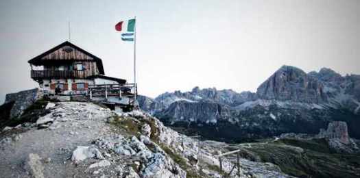
Sleep in Cortina, then catch an early bus to the trails. Of many great options, the best panorama for lunch just might be from the Nuvolau mountain hut (Refugio) built 1883, first in the Dolomites. It’s impossibly located on the very top of a 2600 meter (8530 foot) cliff.

Nuvolau

To get there you need the hiker’s shuttle bus to drop you at passo Falzarego on the SR 48. At least six different paths of varying difficulty get you to Nuvolau. Look first at Alpine Trail #439 via the Rifugio Cinque Torri (5 Towers). The Refugio offers 26 cramped beds. But with bus access this convenient, it’s best to day hike out of Cortina. (There have been many complaints from those sleeping at Nuvolau.)

Bring your own gourmet Italian food and drink from town. Or order from the hut menu. Nuvolau is only open during the hiking season, June 15 to September 30. August is busiest. That’s when Italians holiday.

The Dolomites are one of our top 10 hiking regions in the world.

The crazies at sram somehow got up there with their mountain bikes!

Nuvolau
_____

Related:

Do your shopping at Cooperativa di Cortina, founded 1893. But count your change. The ladies at the till were shortchanging foreign tourists last time we were there.

If you are flying in, book the direct Cortina Express bus from Venice’s main airport, Marco Polo.

Trip Advisor Cortina d’Ampezzo gives up-to-date recommendations for hotels in all price ranges. Cheapest is tenting.

Ganden to Samye, Tibet

 
Unforgettable trekking in one of the most beautiful areas of Tibet. A pilgrimage between two holy sites.

Ganden Monastery to Samye Monastery.

Ganden

AT A GLANCE

  • one of the most popular treks in Tibet
  • 4-5 days
  • best months April – October
  • tenting is required
  • independent hiking is illegal, though some foreigners do it anyway
  • Ganden Monastery 4,300m to Samye 3540m  is a traditional pilgrimage route
  • you’ll suffer many hassles traveling in totalitarian China

Map.ChinaTibetread more on our new Ganden to Samye information page

We’ve updated (and moved) that page.

It’s been 15 years since we’ve done it. Leave a comment if you know of a more recent trip report.

new guidebook – Trekking in Ladakh

I’m pondering a trip to the Indian Himalaya, Oct/Nov 2013.

Happily, there’s a great new Cicerone guide published Dec 2012.

Known as “Little Tibet” for both its landscape and culture, Ladakh lies at the northern tip of India.

CiceroneThe region is bisected by the great River Indus and neighbours Tibet and Kashmir.

This quiet corner of the Himalayas has developed a strong trekking culture over recent years for adventurous trekkers. Trekking in this remote, high-altitude region is extremely challenging, as paths are not signed and there are only a limited number of villages. However, its magnificent landscape (a huge area full of limitless trekking possibilities), hospitable people, rich heritage and limited number of tourists make Ladakh an amazing destination.

The guide includes background information on local culture, history and religion, as well as all the planning detail you need on crucial aspects such as environmental responsibility, health and safety in the mountains, trekking practicalities and preparation for altitude.

Amazon

I’ll buy that. And consult these others:

Ausangate Circuit, Peru

One of our top 10 hikes in the world is the Ausangate Circuit in Peru.

Best timing for 2013 is before or after Saturday May 25th to Tuesday May 28th. That’s the famous Quyllur Rit’i festival celebrated nearby.

Best book that flight right now. 🙂

13EXPLORER1_SPAN-articleLarge-v2It’s also called the Snow Star Festival.

We did both Ausangate and the festival in 2005.

You circumambulate the highest peak in southern Peru, sacred Ausangate 6372m (20,905ft).

Four high passes between 4757m – 5165m.

70km (43.5mi) plus sidetrips, most hikers tent 4-5 nights. Hotsprings at start and finish of the trek.

alpacas

Check our recently updated information page on Ausangate.

dayhiking Pacific Rim National Park

I got a chance to hike on the wild west coast of Vancouver Island on May 14th.

6 hikes / trail runs.

Parks Canada handed me this map. And recommended a number of hikes.

park

4+5 South Beach Trail + Nuu-chah-nulth Trail (out and back)
7 Rainforest Trail A
7 Rainforest Trail B
8 Combers Beach Trail

Wild Pacific Trail (Ucluelet) – Lighthouse Loop section

lighthouse-loop-300-pixels

Trails in Canada are as well maintained as any in the world. There is a ton of boardwalk in these temperate rainforest hikes.

boardwalk

Instead of watching your boots, you’ll be looking up at the huge old-growth trees.

When Captain Cook first arrived, the old growth forests looked endless. Only 1 in 10 of those ancient trees still stands today.

pacific-rim-national-park-rainforest-trail

Pacific Rim National Park Reserve of Canada – Hiking – Long Beach Unit

HIGHLY recommended. 🙂

long hike Olympic National Park, WA?

For multi-day wilderness adventures, Rangers told me the higher, dryer east half Olympic National Park was best. Many options depending on how many days you have.

Olympic

Just looking at a map, I’m thinking to start at Deer Park trailhead (5400ft) because it’s high. Decide where to exit based on Ranger’s advice, weather and the number of days I’ll have.

Leave a comment if you’ve hiked overnight on the East side of the Park.

SPOT Global Phone

Stephen Regenold:

It weighs just 7 ounces and is 5 inches tall. The phone body is made rugged for the outdoors. Announced today, Spot LLC will start selling a satellite phone for $499 this week. …

The phone has an optional data kit to connect it to a computer, letting you get online to check and respond to emails, upload photos, or post to Facebook from deep in the wilderness. …

The battery will last for 4 hours of talk time (36 hours on standby) before it needs a recharge.

Calling plans start at 25 cents a minute (and $149.99 for monthly unlimited voice) when the phone goes on sale this month online and at retailers now including REI, Cabela’s, West Marine, Eastern Mountain Sports, Gander Mtn, Bass Pro Shop, and Sportman’s Warehouse.

spot phone

Call from Anywhere. SPOT launches Satellite Phone for Outdoors

West Coast Trail 2013

by site editor Rick McCharles

I’m booked for my 4th WCT. 🙂

It’s been our #1 hike in the world since 1999.

Getting ready, I’m drafting a new WCT information page. Leave comments on that page, if you have anything to add.

If you don’t know the adventure, watch my favourite WCT video.

CBC West Coast Trail documentary 2007 (23min)
Click PLAY or watch it on YouTube.

Annapurna out, Everest in

by site editor Rick McCharles

For years the Annapurna Circuit in Nepal has been one of our top 10 hikes in the world. I loved my own trip there in the 1990s.

But, year after year, road building has degraded the experience.

Here’s one of Andrew Ostrowski’s photos from the ‘Circuit’ …

We’ve replaced Annapurna on the top 10 with …

Everest Base Camp / 3 Passes

There’s NO shortage of information on how to hike to Everest Base Camp (5,320m / 17,450ft) in Sagarmatha National Park, Nepal.

But the best route is fairly new, via three high passes:

Kongma La (5,535m)
Cho La (5,380m)
Renjo La (5,388m)

You can do one, two or three of those.

If 3 Passes are not challenging enough, you can opt to side-trip 3 trekking peaks:

Gokyo Ri (5,483m) … similar vista to Renjo La
Kala Pattar (5,545m)
Chukkung Ri (5,550m)

Pokalde Peak 5806m (19,048ft) is an option, too. But requires a Climbing permit as does the much more popular Island Peak 6,189 m (20,305 ft).

The sacred Gokyo Lakes is a superb side-trip. Don’t miss it.

everest-3-passes-mapdetails – Everest Base Camp / 3 Passes

The focus of that page is the difficult 3 Passes route. For independent trekkers.

Pokhalde Base Camp on the Kongma La 5535m

related – our updated top 10 best hikes list.