hiking Sendero Enladrillado, Chile

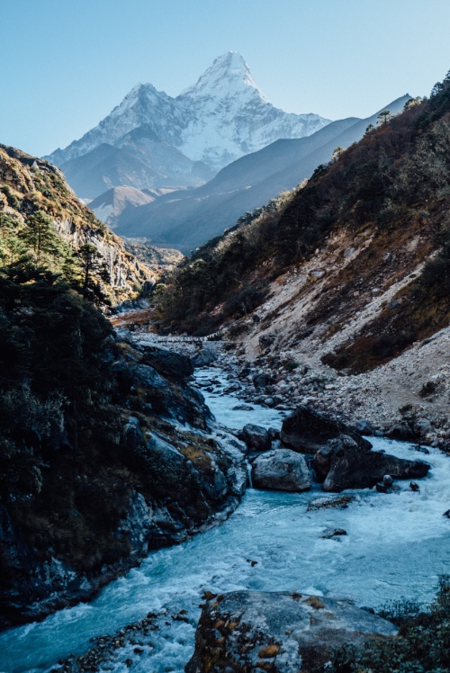
“… Arguably the best hike in all of middle Chile, the full-day Sendero Enladrillado takes you to the top of a unique 2300m basaltic plateau with stunning views. …”
– Lonely Planet

Descabezado volcano
Descabezado volcano

How could I resist? 🙂

I reached Reserva Nacional Altos de Lircay from Talca bus station, 65km west of the Park. A sunny summer Friday afternoon, my Buses Vilches contraption headed to the mountains was packed. I was lucky to get a seat, one of the few perks of having grey hair.

From where the bus drops you off after 90min it’s around a 2km walk uphill to the Conaf administration building. Open even though it was after opening hours.

An older gentleman checked me in but – for some reason – charged me double for Park entrance. 10,000 rather than foreigner’s rate of 5000 pesos. I assumed the extra 5000 was for camping. At the time.

I was given a simple map and instructions on the best hike. A counterclockwise loop seeing all the highlights over about 8 hours.

It was dusk by the time I walked uphill another 2km (in crocs) to Camping Antahuara, also run by Conaf. The boys at the campground – after seeing my two Park entrance receipts, did not charge me for camping. Gracias.

IMG_4293

Conaf’s Camping Antahuara is an excellent campsite. And I actually had electricity!

IMG_4294

I listened to audio books, Spanish lessons. And got to sleep early.

Morning dawned bright and sunny. Again. It was a summer heat wave in Chile.

By 8am I was started up to Enladrillado carrying only a day pack. It felt easy.

IMG_4297

IMG_4304

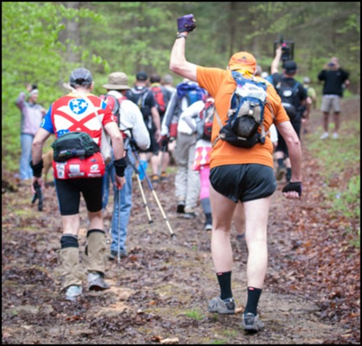
This is a popular hike. I saw nearly as many people as lizards.

IMG_4309

It’s steep in places. I recommend you hike right to left, climbing more gradually to the Enladrillado, descending from the Laguna viewpoint.

Perfil_altos_de_lircay

Enladrillado is great. But if you’d climbed all the way up here without seeing Descabezado (“decapitated”), you’d be disappointed. This is a hike for good weather. Phone the Ranger station (71) 220 9517 to check on he visibility before heading up.

IMG_4321

It was getting hot.

IMG_4318

I hid out in the shade dreaming of hiking all the way to Descabezado base camp. And climbing. Some day.

Cerro Azul
Cerro Azul

Starting here and continuing to Parque inglés is called the Circuito de los Condores. (Condor Circuit)

That’s what I should have done this trip. 😦

Next I started looping back towards Camp across the dry plateau.

IMG_4334

IMG_4341

Up high I saw only 3 small water sources. It’s not easy for flora or fauna to live up here.

IMG_4344

IMG_4316

Some cloud was rolling in down in the valley. Rangers had warned that a “little rain” was in the forecast for the weekend.

IMG_4333

Here’s the viewpoint overlooking the laguna.

IMG_4352

It’s a lot further down than it looks.

IMG_4355

Though all kinds of signage makes clear that camping is not allowed, it appears the rule is not enforced. Many hikers up here were carrying sleeping bags.

This large group did not get to the top of the plateau until 1:30pm. Sadly the clouds were climbing higher. They’d likely miss the views.

IMG_4358

I was back in camp before 4pm. The only highlight on my return this fox. In Spanish you can call him “El Zorro”.

IMG_4362

I’d seen his cousins in Patagonia (10yrs ago) brazenly rob tents. I resolved to be more careful hiding away my camping food in Chile.

IMG_4366

Enjoying the campground, I decided to stay another night rather than bus back to the city. It rained all night. 😦 I missed the morning bus by 2 minutes 😦 delaying my exit by about 5 hours.

Still, I highly recommend Sendero Enladrillado in good weather. I’ve added it to our list of best hikes in South America.

The best guidebook I’ve seen is Trekking por Chile 40 Rutas 2015 (Spanish). It’s available in larger bookstores in Chile.

related wiki – Altos de Lircay circuit, Enladrillado

NZtracker – Milford | Kepler | Routeburn

It can be difficult to get a booking for these famous New Zealand hikes. Especially Milford.

nztracker.nz will send you email alerts for available huts so that you can immediately book the most beautiful tracks in the world.

Click PLAY or watch it on YouTube.

nztracker.nz

related – I Spent A Year Exploring New Zealand To Bring Back These Photos And It Blew My Mind

NEW – Three Capes Track, Tasmania

The Three Capes Track is a brand new, 4-day, 46 km, bushwalk in cliff-hugging wildness of Australia’s far south-east. Forty eight permits are issued each day, and the walk is self-guided.

The track opened Dec 23, 2015 …

The track features over 35 “art” pieces, most of which provide a seat” for walkers to sit and enjoy the natural surroundings of a particular area, whilst learning about the Tasman penninsula’s natural, maritime, and convict history. …

Lonely Planet calls the Three Capes Track “The hottest new travel experience of 2015”. …

3Capes Track – D3 (Munro – Rutakunna [Jan 1, 2016])

ranboze

Nepal open for business

If you’ve been wanting to travel here but have been deterred by recent events, let this ease your mind. The trails are in good condition. Food and water are abundant. The tea houses are staffed. The only thing missing is you.

Chris Brinlee Jr. – Six Months After The Earthquake, Nepal Is Open For Adventure

Nepal

flying to South America today

I’m looking forward to the beautiful Andes. 🙂

Overland Collective photographer and GearJunkie contributor Eric Hanson traveled the Andean spine of South America, from Ecuador to Patagonia, for seven months in 2015. Exploring almost entirely solo, via a mixture of public transportation and trekking, he captured beauty of the rugged mountains of the South American continent.

Eye Candy: South American Time-Lapse Beauty

Click PLAY or watch it on Vimeo.

https://vimeo.com/150951230

the Barkley Marathons

… In the nearly 30 years since the Barkley’s inception, only 14 people have finished the race. …

Outside – How Two Filmmakers Cracked the World’s Most Bizarre Trail Race

Stu Gleman fist pumps at the start of the Barkley Marathons

The Barkley Marathons is a 100 miles (160 km) run and a 60 miles (97 km) ‘fun run’ held annually in Frozen Head State Park near Wartburg, Tennessee in late March or early April.

The course itself, which has changed distance, route, and elevation many times since its inaugural run in 1986, currently consists of a 20-mile (32 km) loop with no aid stations except water at two points along the route and the runner’s parked car at the beginning of the loop. Runners of the 100 Mile version run this loop five times, with loops three and four being run in the opposite direction and loop five being runner’s choice. …

Click PLAY or watch the trailer on YouTube.

Buy it.

Hendrik Morkel – NO new gear?

Hendrik is one of the few gear testers I follow.

But inspired by Craig Wisner in 2012, Hendrik is going to try to do 2016 without buying anything new.

Just the other day I was in REI, swearing not to make any purchases. Yet left with new ultra light Powerflyte Gloves. (They were HALF PRICE! 🙂 )

gloves

What’s the upside of taking a year off shopping?

… Next year, in 2017, you can purge on the latest and greatest outdoor gear, which will most certainly be better than in 2016!

In 2016 you can actually test and use all the gear you have already!

You can go on more trips, because you’ll save hundreds of €£$ on not buying new equipment …

Hiking in Finland – No Gear Year

Good luck, Hendrik.

ALL-IN-ONE sleep system

The patented Polarmond® concept offers the functions of a tent, sleeping bag and sleeping mat all in one.

The ALL-IN-ONE sleep system has a self-warming modular design and can be temperature regulated to help alpinists, expedition members and trekkers achieve optimal sleeping comfort. This results in increased recovery and maximum performance at temperatures down to -30 °C. …

details

Schnittbild-Polarmond-ALL-IN-ONE-Biwak-800x270

Goes on sale March 2016.

(via more ideas)