Pyrenees High Route: Etsaut to Cauterets

Ultimate Gear Lists:

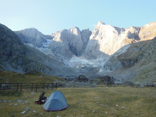
The Pyrenees High Route (Haute Route Pyrénées, HRP) is a long distance hiking trail that follows the mountainous divide along the French-Spanish border. …

The 497 mile (800 km) long HRP trail follows the backbone of the mountain range all the way from the Atlantic Ocean in  the west to the Mediterranean Sea in the east. On average it takes about 45-50 days to complete. Since many hikers are unable to spare the time, expense, or effort necessary to thru-hike the entire trail, we suggest an alternative 5-6 day itinerary below that covers some of the most stunning sections of the trail. …

  • LENGTH: 45 miles / 72 km
  • DURATION: 5-6 days
  • TYPE: One-way
  • START: Etsaut, France
  • FINISH: Cauterets (Pont d’Espagne), France
  • BEST TIME: July & August

It is also worth noting that the Pyrenees are home to two other long distance trails: the French GR10 and Spanish GR11. Both of these trails also follow the Pyrenees mountains for their entire length. However, the GR10 and GR11 each remain exclusively on one side of the French-Spanish border, travel at a lower elevation, and are well marked. Whereas the HRP trail constantly hops back and forth across the border, follows the highest part of the mountain range, and is not officially marked. …

PYRENEES HIGH ROUTE (HRP) HIKING GUIDE


climbing Mt Wells, Victoria B.C.

Trip report by BestHike editor Rick McCharles.

Only 3km return, this scramble is considered difficult. On the other hand, there are plenty of comfort ropes to assist you. Some of the descents might be tricky in the rain.

Very pretty is this old pipe now covered with moss. They bricked the ends to keep critters and kids out.

… offering views as far away as downtown Victoria, Juan de Fuca Strait, and towards Sooke …

Victoria Trails 

win a trip for 2 – climb Mt Toubkal, Morocco

I did the Toubkal Circuit independently last year finishing with a climb to North Africa’s highest summit.

Closest international airport is Marrakesh.

In collaboration with Mount Toubkal Adventure, Bookatrekking.com gives away a complete trip to the highest mountain in North Africa.

The trip includes accommodation (2 nights in Marrakech), meals, luggage transport (on mules) and guides to the top of Mount Toubkal!

Flights are not included.

Apply here.

related – 10 Tips to Summit

NOTE: Two female Scandinavian hikers were killed by wannabe ISIS jihadists last year.

15 iconic Oregon coast hikes

From towering Neahkahnie Mountain to the chasms of Cape Perpetua, there are hiking trails that run up and down our gorgeous coastline, exploring the forests, dunes, tide pools and beaches that make it up.

… One of the best things about hiking the Oregon coast is how easily you can access such incredible views …

OregonHikers.org

Blacklock Point from Floras Lake Hike

Alberni Inlet Trail, Vancouver Island

trip report by BestHike editor Rick McCharles

Stage 1 – Port Alberni to China Creek

  • 15 kms one way (I stopped at 13 kms)
  • 6 hours (I took 4 hrs)
  • elevation gain 3937 ft
  • Ship Creek Road trailhead to China Creek trailhead
  • panorama of the city of Port Alberni
  • route options: Follinsbee Creek (easier) or Lookout and the old Copper Mountain Trail (harder)
  • moderate difficulty
  • plenty of ups and downs
  • some fallen logs to scramble

My Dad dropped me at the Port Alberni visitor centre. This was the start of my Pacific N.W. BikePacking tour.

For my first hike, I used the paid version of the AllTrails app. And I needed AllTrails as parts of the trail close to China Creek are overgrown and difficult to find.

Even better is the Relive app. Click PLAY or relive my hike on YouTube.

It was tougher than I expected with non-stop up and downs.

There are many bears in the area. This was the only sign I saw.

In fact, the only animal life of interest was the first Garter Snake I’ve seen this season.

Wild flowers lovely.

This trail is maintained. But the section closer to Port Alberni is in far better shape.

At times you have to rely on flagging tape to find the trail.

One highlight is a vista of Port Alberni from on high.

The coastal section is cool. Boom.

All in all, I’d recommend the Alberni Inlet trail.