Colca Canyon, Peru

BBC and Lonely Planet posted an article on one of the best hikes in the world:

Most first-time visitors to Peru make a beeline for the ruins of Machu Picchu, without realizing that they are passing within a bus ride of the epic Colca Canyon.

Slicing through the High Andes like a giant fissure for more than 100km, Colca is the world’s second deepest canyon, approximately 3,400m at its deepest point — a shade shallower that the nearby Cotahuasi Canyon and nearly twice as deep as the US’ Grand Canyon. …

With a few days to spare and minimal planning, it is easy to shoehorn Colca Canyon into a wider Peruvian trip. The area is best accessed via Arequipa, Peru’s second largest city …

The Calera hot springs are an acclimatizing 3km walk up the valley to a scenic spot by the Colca River. Once there, recline in a simple alfresco pool as screaming zip-liners slide terrified across the canyon overhead. The zip-line stretches for 600mbetween the canyon walls simulating the flight path of an Andean Condor. …

read more – Exploring Peru’s epic Colca Canyon

Check our Colca Canyon information page.

Consider climbing 5822m (19,101ft) Misti Volcano on the same trip.

You need enough time for acclimatizing to altitude, of course.

barefoot to Kilimanjaro

The barefoot movement is going too far with this project.

Ross on Science of Sport:

Only 3 days to go before I jet off to Kilimanjaro to tackle Africa’s highest summit, and the world’s highest free-standing mountain…barefoot…

My mission is to help get ONE person to the top barefoot, and to do it safely. …

The Barefoot Kilimanjaro Challenge

It’s an attention getter, that’s for sure. Funds raised go to the Red Cross Children’s Hospital in South Africa.

related – Killian Jornet record for summitting Kilimanjaro in light shoes – 7 hours 14 minutes return. (VIDEO)

The Year in Volcanic Activity

The Atlantic:

Out of an estimated 1,500 active volcanoes around the world, 50 or so erupt every year, spewing steam, ash, toxic gases, and lava. In 2011, active volcanoes included Chile’s Puyehue, Japan’s Shinmoedake, Indonesia’s Lokon, Iceland’s Grímsvötn, Italy’s Etna, and recently Nyamulagira in the Democratic Republic of Congo. In Hawaii, Kilauea continues to send lava flowing toward the sea, and the ocean floor has been erupting near the Canary Islands.

Indonesian worshipers descend from the crater of Mount Bromo in East Java province on January 28, 2011. The worshipers gave offerings to the god of the mountain, praying for the safety of local people. (Aman Rahman/AFP/Getty Images)

See all 36 photos – The Year in Volcanic Activity

I have friends hiking the Tongariro volcano in New Zealand right now.

(via kottke)

top travel destination is … ICELAND

According to Lonely Planet Best in Travel Readers’ Choice Awards.

… ‘Incredibly friendly, amazingly beautiful and one hell of a good time. Bars followed by geothermal hot springs.’

‘Iceland is the place to be in 2012 to see incredible displays of nature! The country of Iceland is currently experiencing two “maximum cycles”: One to do with increased volcano activity and another to do with the increased aurora activity for 2012.’ …

… ‘The wonders and creativity of nature at its best – untouched by humans…to this point. Geothermally heated pools to refresh the soul, literally seeing the rift valley between the American and European geological plates, visiting glaciers, seeing a real volcano, walking on terrain that cannot be seen anywhere else in the world…AND who wouldn’t want to see a puffin!!’ …

details on Lonely Planet

Marines climb Mt Etna

… On the morning of Oct. 25, about 20 Marines with Special Purpose Marine Air Ground Task Force 12 scaled its slopes.

… SCTT-2 is one of four specialized Marine teams in Italy as part of a newly formed unit tasked with mentoring African militaries dealing with regional terror threats. Their time spent in between missions, leaders have stressed, doesn’t have to go to waste.

The hike was designed to teach the Marines a lesson in the rigors of operating in a mountainous environment. …

read more on dvids

Some packs were as heavy as 40kg (88lbs)

_____

This is all good. But I can’t think of the American military in Italy without fuming (again) over the Cavalese cable car disaster of 1998.

… The disaster, which led to the death of 20 people, occurred when a U.S. military plane cut a cable supporting a gondola of an aerial tramway. …

The victims’ families got money but not much else. Another sorry episode in American military history.

It’s also known as the Strage del Cermis (“Massacre of Cermis”).

not hiking Mt Aso, Japan

Mount Aso (阿蘇山 Aso-san) is the largest active volcano in Japan, and is among the largest in the world.

It stands in Aso Kujū National Park in Kumamoto Prefecture, on the island of Kyūshū.

Its peak is 1592 m above sea level. Aso has one of the largest caldera in the world (25 km north-south and 18 km east-west). The caldera has a circumference of around 120 km (75 mi), although sources vary on the exact distance. …

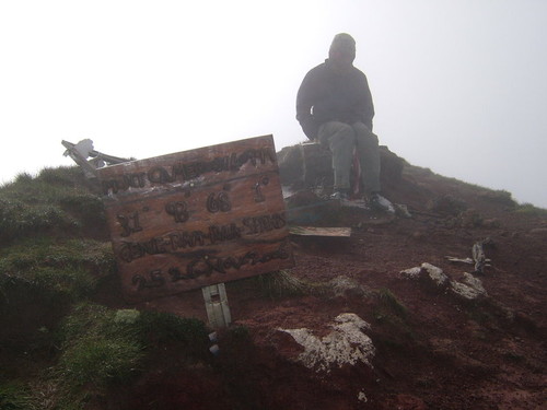
Aso is one of the best hikes in Japan. So — as expected — I wasn’t able to hike it.

It seemed we were well organized for this one, up early and arriving by rent-a-car before the tour buses.

Yet the Buddha said we could not continue up the mountain. Trails were closed due to Sulphur Dioxide emissions.

I briefly considered going off trail. But the stink really was choking.

… And, in fact, I understand the trails and ropeway are often closed for this reason.

More bad luck for me on this trip.

Here’s the scoop on how to actually walk that destination – Hiking in Japan blogMt. Aso (阿蘇山)

The most iconic image is this unusual feature, the ‘rice mound’.

That’s from a CNN article – Mount Aso and me: How I risked death on a Japanese volcano

See photos of Aso on Flickr.
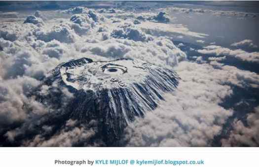
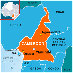
hiking Mt Yufu, Japan

trip report by site editor Rick McCharles

Mount Yufu (由布岳 Yufudake) is a 1,583.3 m (5,195 ft) volcano, located on the border of Yufu and Beppu, Ōita, Japan.

15km

Yufu is one of the hikes recommended in Lonely Planet Hiking in Japan.

I chose it as access is easy by public transport. In fact, when you get off the train in Yufuin, you know exactly where you’re going.

Or not. I spent perhaps 90min from that point before finding the actual trailhead. This is typically the end of the Yufu-dake hike, not the start.

Once on the trail, it’s a fun and easy ascent … for a volcano. This far south, there are still some Autumn colours.

all signage is in Japanese

This far south, too, there are still plenty of hikers in November. Most were headed the opposite direction.

Decision time. Which of the twin peaks should I climb?

I took the one closest to Yufuin, Nishi-mine (1548m). It’s slightly higher and harder.

In fact, it turned out to be quite a scramble. This point of exposure in particular convinced a couple of men to turn back and try the other.

Finally, I saw a hiker atop Nishi-mine.

He cleared out when I arrived. As did the clouds.

Fairly late in the day by this point, I left a Summit Stone, and hustled down to the nearer Yufu-tozan-guchi trailhead where I could catch a bus in either direction.

It was 45min before one arrived. A gentleman was tenting there, well prepared to do the hike next morning. We were both reeking of shōchū by the time the bus pulled up.

The Yufuin railway station has a hotsprings foot bath for waiting passengers. I couldn’t resist.

Yufuin is a hotsprings resort town, in fact, quite famous. I recommend it. I stayed at a great hostel in Beppu, though, another hot springs resort.

If you love hot springs, southern Japan is the place to go.

more photos from my day hike

SUCCESS on Mount Yōtei, Japan

trip report by BestHike editor Rick McCharles

My alarm went off at 4:40am.

Yet it was 12:30pm before I started up the trailhead to climb Mount Yōtei out of Niseko, the most popular ski resort in Japan.

… often referred to as the “Mt. Fuji of Hokkaido” …

when has the weather been this good?

Here’s how the volcano looked when I came knocking.

Lonely Planet Hiking in Japan:

One of the toughest day hikes around with a 1500m climb up to a perfectly shaped volcano …

My guidebook called it 8-10hrs round trip. Signage said it took longer than that. There was no way I could make it this day.

… I started up.

Footing was good. Weather excellent (so far).

About half way up I met a savvy Japanese hiker already coming down. He was concerned at where I was on the mountain relative to the time. I assured him I’d be turning around quite soon.

… But you know, guys like me, Rob Hall & Gary Ball — we can push the turnaround time later than most.

And the weather actually got better instead of worse as I gained elevation.

When I saw the mountain hut I knew I’d make the top.

Normally manned by a warden, it had been locked up for weeks. Almost nobody hikes this late in the season.

I only stayed on the crater rim for about 3min as it was already 4pm. … And it gets dark starting about 4:30pm.

The second time on the crater rim I was furious. I’d dropped my camera in the snow when starting to RUN down the mountain. And then hustle back up. It’s now 4:20pm.

The welcome lights of the trailhead campground toilet. It’s 6:30pm.

The campground had been long closed. Yet incredibly the washrooms were left open and powered on. Thank-you Japan.

I tented here all alone, hoping to see one of the infamous pesky foxes. They’d long given up on the campground too.

See all my photos from this day hike.

I know what you’re thinking — this scramble was a “success” ?!

Success is relative on this trip. 🙂

Hiking Wakkanai, Japan

trip report by site editor Rick McCharles

My “plan” was to travel to northernmost Japan and catch the ferry from Wakkanai to the remote island Rishiri-Zan.

In my dreams, I’d camp one night. Then do the 8hr, 18km coast-to-coast over this volcano (1712m). (Oshidomari track up, Kutsugata track down)

more photos by le.sdf.free.fr

Certainly this is one of the best hikes in Japan. And that photo is a postcard, not reality.

… Unfortunately, it’s nearly impossible to pull off this hike later than September due to: unstable weather, hostels & campgrounds being closed and/or trails being impassable due to snow or washout.

I only conceived the faint hope of trying for it late October because I saw a fleeting TV weather report showing a smiling sun over the north tip of the island. …

Waking early the morning of my intended day hike, the weather was normal — grey and drizzling. I went back to sleep.

Depressed at having yet another of my hiking plans dashed, I defaulted to a lazy day wandering the town. Then catching the train and abandoning northern Japan altogether.

Unexpectedly, the weather cleared up. And I had an excellent day hike walking directly from the train station after locking up my pack.

First stop a tranquil Temple much adorned with gardens and statuary.

Fall colours were a highlight of the day.

I climbed up above town to Wakkanai Kōen (稚内公園) park. That’s the “Russian” island of Sakhalin, in the distance.

How about this?

I began to wonder whether I should have jumped on the ferry. Nope. Here’s the micro-climate cloaking the volcano:

Instead I decided to walk the bluff, then descend down to the coast via animal trails.

Here are the animals.

This region is famed for kelp though there wasn’t much drying end of October.

In peak times these racks might be covered with kelp.

Like other parts of the world cold and inhospitable, locals like bright colours, making long winter nights less depressing.

This turned out to be one of my best hiking days in Japan :). … But I still caught the train south when it got dark.

Rishiri-Zan volcano must wait.

See more photos from my day hike of Wakkanai.

related – Climbing Rishiri-Zan trip report (2004) by Cameron L. Martindell