16 dead (so far) on Mt Kinabalu

… Malaysia’s Mt. Kinabalu, a 4095 meter (13,435 ft) trekking peak on the island of Borneo, was struck with a 5.9 magnitude earthquake that claimed the lives of at least 16 people, and left dozens of others injured and stranded on the mountain for a time.

There are believed to be at least two others still missing, and the death toll could rise even further as search and rescue teams continue their efforts. …

Of the 16 climbers who perished on the mountain, reports indicate that seven of them were from Singapore, Six were Malay, with the additional causalities coming from the Philippines, China, and Japan. …

Earthquake on Mt. Kinabalu Kills 16 Climbers, Injures Dozens More

OLYMPUS DIGITAL CAMERA

top 10 trekking peaks

We’ve updated our top 10 section. With input from Kraig Becker, of the Adventure Blog. He’s recently back from his second climb of Kili. 🙂

Top-10#
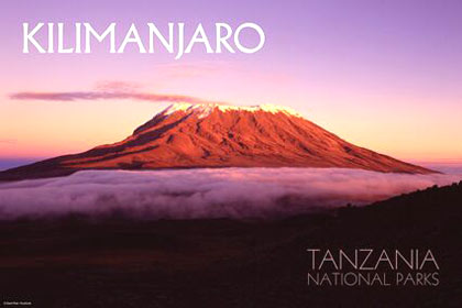
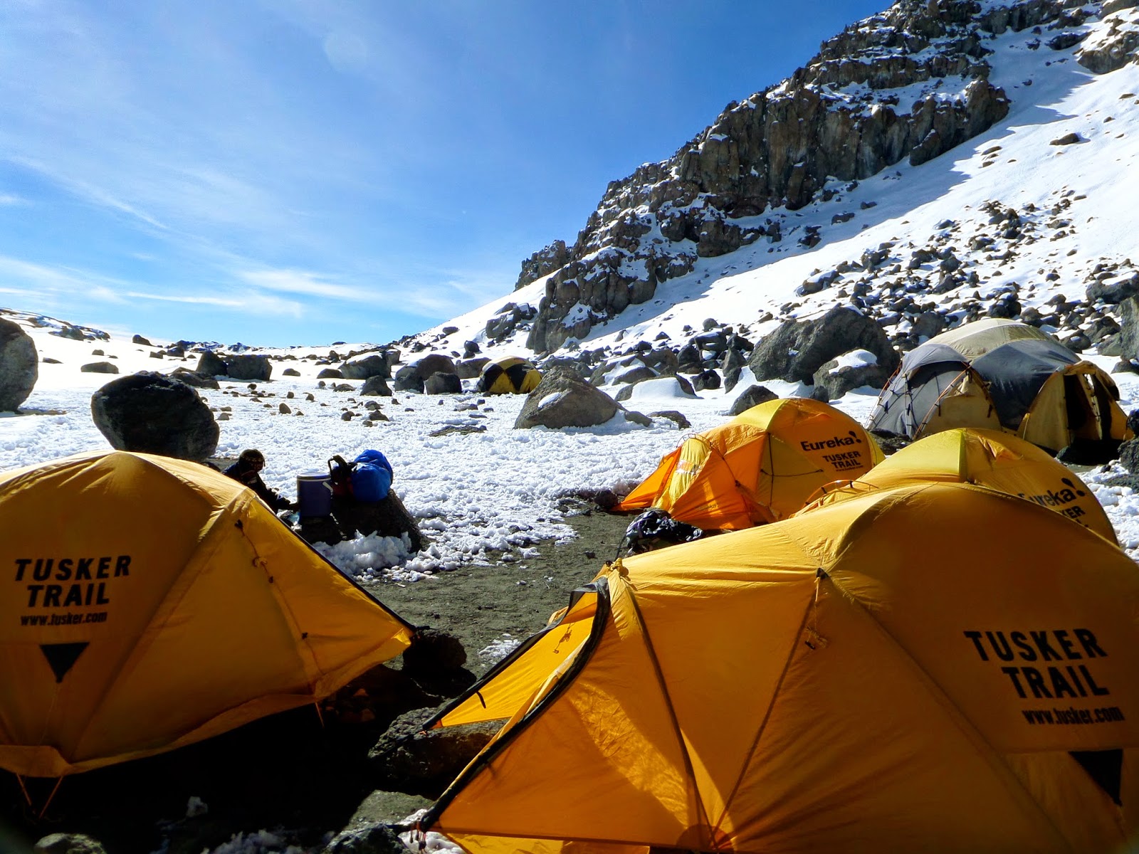
1) Mt. Kilimanjaro, Tanzania 5895m
#2) Cotopaxi, Ecuador 5897m <wiki><pb><sp>
#3) Island Peak, Nepal 6189m <wiki><pb><sp>
#4) Mera Peak, Nepal 6476m <wiki><pb><sp>
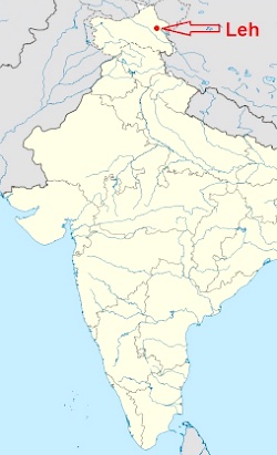
#5) Stok Kangri, India 6153m <wiki><pb><sp>
#6) Huayna Potosí, Bolivia 6088m <wiki><pb><sp>
#7) Misti Volcano, Peru 5822m
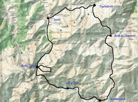
#8) Mt. Toubkal, Morocco 4167m <wiki><pb><sp>
#9) Mt. Rainier, USA 4392m <wiki><pb><sp>
#10) Mont Blanc, France 4810m <wiki><pb><sp>

Aconcágua, Argentina 6,960.8m can be a walk-up. But not many would be willing to call it a trekking peak. 🙂

Trekking peaks are mountains under 7,000 metres (22,970 ft) climbable by anyone with a moderate amount of mountaineering experience and minimal gear.

Others considered for the top 10:

  • Chimborazo, Ecuador 6,268m <wiki><pb><sp>
  • Khüiten Peak, Tavan Bogd, Mongolia 4374m <wiki><sp>
  • Mt. Elbrus, Russia 5642m <wiki><pb><sp>
  • Lhakpa Ri, Tibet 7045m <pb>

Leave a comment if your favourite walk up peak is not listed.

Toubkal Circuit, Morocco

The Hiking Life:

Distance : 60km (72km if you include an ascent of Jebel Toubkal).

Avg.Time : 4–6 days

Start / Finish: Imlil

Regular public transport available to and from Marrakech.
Season :

Late spring and early autumn are the ideal times to do this trek. Summer, despite the heat and lack of water, is peak season and is often inundated with foreign trekking groups. …

Toubkal Circuit, Morocco, 2008

morocco

snow

map

There are a number of guidebooks available. Route finding is not all that difficult. You can do it alone unless you opt to climb the highest mountain in north Africa on the same trip.

related:

Ascent for Alzheimer’s

Kilimanjaro.

Since 1998, the Ascent for Alzheimer’s has seen over 180 committed Canadians go on a journey to hike to the summit of Mt. Kilimanjaro. These dedicated participants fundraise to contribute to research for a cure and to help ensure that those impacted by dementia have access to support services and education resources. …

Introducing the 2015 Ascent for Alzheimer’s Team

Ascent for Alzheimers

(via Dsd Stones)

new Kilimanjaro route – 9 days

Adventure Blogger Kraig Becker:

… When selecting the route for the Climb for Valor, the team at Tusker Trail decided that they wanted to do something a little different. The idea was to give the climbers on our team a complete unique look at the mountain, along a route that is seldom hiked. We began by entering Kilimanjaro National Park at the Londorossi Gate and proceeding up the traditional Lemosho Route along the western flanks of the mountain. …

On Day three we began to divert from the Lemosho Route at last and ventured out onto the all-but abandoned Northern Circuit of the mountain. At this point, we left all other teams behind and had the trail completely to ourselves. …

Kilimanjaro 2015: The Route

Crater Camp 5700 meters (18,700 ft)

Charity trips: Machu Picchu and Kilimanjaro

If you’ve always wanted to get to either of these superb trekking destinations, check this opportunity.

June 2015: Inca Trail to Machu Picchu for Education

July 2015: Kilimanjaro Climb for Education

Make a Difference Now organizes trips to help raise funds and awareness for education in developing nations. 🙂

Mad Charity Kili Machu Picchu

details – gomadnow.org/get-involved

Thanks to Theresa Grant for the link.

Langtang Trek – day 4

Trip report by site editor Rick McCharles

Langtang Village 3430m to Kyanjin Gompa 3830m

We stayed at the Tibet Hotel in Langtang. But all teahouses in any given location are near identical. It really doesn’t matter which one you choose. Cost and quality are the same.

As usual, I waited until the mob of trekkers, porters, pack animals and guides cleared out of the village. The last thing I want trekking in the Himalaya is rush hour.

I sipped milk coffee and enjoyed the morning sun waiting for trails to clear.

P1310953

These Himalayan villages are interesting. Especially after the tourists have disappeared in the morning.

P1310956

The stupendous wide Langtang valley runs east-west, parallel to the Tibet border, enjoying a lot of sun.

P1310976

A highlight for me are the many different grazing animals, especially the Yaks.

P1310977

Long, long mani walls and many stupas remind you that this is Buddhist Tibet not Hindu Nepal.

P1310988

In 2014 another one of these superb bridges was completed.

P1310991

Kyanjin Gompa. End of the line for many Langtang trekkers.

P1310997

I caught up with my group for lunch. Egg noodle soup with extra egg and egg noodle chowmein.

P1320003

No meat is sold in Langtang valley. The chickens are here strictly for eggs. Yaks strictly for milk and cheese.

Up, up, up right after lunch.

P1320007

We would “sleep low, climb high”. Acclimatization paramount.

P1320009

There are stupendous views looking towards Tibet. Monstrous glaciers.

P1320023

Kevin and Delphine with their guide BJ. He led my Manaslu Circuit trek last year. And I hope to trek with him again in future.

P1320029

We could have stopped here at the first viewpoint. But the ridge walk up was too tempting.

P1320032

P1320042

Vistas got better and better.

P1320040

P1320070

Photos give you just a hint of the magic of the Himalayan light. You feel you can touch the highest mountains in the world, the relief and contrast so striking.

P1320056

About 45min up from the first prayer flags we reached the summit of Kyanjin Ri at 4850m. I left a Summit Stone.

P1320066

Prayer flags are believed to have originated with Bon, which predated Buddhism in Tibet.

P1320065

P1320063

BJ knew a different and easier way down. We descended via this sandy watercourse.

P1320075

That night we learned a guy at our lodge on his own had tried a different descent on Kyanjin Ri, getting lost. Sometimes it’s nice to have a guide. 🙂

On the return we visited Kyanjin Gompa itself, sadly now disused. The monks long gone. Only about 3 times a year do some return for festivals.

An elderly woman unlocked it for a donation.

P1320085

P1320094

P1320092

I was more interested in the food and fuel being stored away for the coming winter.

P1320089

P1320091

By dinner we were tired and had slight headaches. It had been a big day for altitude. Perhaps we pushed it too high. Some on our exact same itinerary were down, altitude sick.

P1320097

The night sky was fantastic.

see all my high res photos from this day

day 0 | day 1 | day 2 | day 3 | day 4 | day 5 | day 6 | day 7 | day 8 | info | … Gosainkund

climbing Fanispan in a day

trip report by site editor Rick McCharles

“the Roof of Indochina”

AT A GLANCE

  • map Fansipan3,143 meters (10,312ft), Fanispan is the highest mountain in Indochina
  • northwest region of Vietnam, near the Chinese border
  • 9km southwest of Sapa (Sa Pa), a gorgeous hill station developed by the French
  • pine forests, bamboo thickets and jungle

Oct 20, 2014

P1310402

Breakfast at the fantastic Unique Hotel starts 7am. Since I was leaving at 5am, the cook awoke early and put together a takeaway breakfast for me. 🙂

I arrived at Sapa O’Chau travel agency at 5:10am for the 5:30 rendezvous. Guide and driver were there already, so we departed instantly.

By 5:30am we were marching briskly up the trail. In the dark.

“Silver”, my guide, spotted a wounded bird near the Ranger Station. Knowing that some dog would dispatch him in the morning, he carried the bird along with us until finding a safer place in the forest.

P1310342

We started early because I opted to climb Fanispan in one day US$95, rather than the normal US$180 2-day itinerary.

P1310348

Silver quickly decided I was strong enough to make it. I hoped he was right.

The trek is wet. And muddy. At the bottom you are often walking in creek beds and runoff streams.

P1310355

Happily for me, it had been very dry of late. My feet did not get wet over the entire day!

The best sections are ridge walks with misty valley vistas far below.

P1310436

P1310442

Surprisingly, long sections of the ridge are protected with concrete railings. They are well built and seem to be enduring the climate very well.

P1310435

I asked my guide about poisonous snakes. He laughed, saying the snakes this high are very wary. People don’t see them. But in his village, Kat Kat, there are many, many.

P1310358

Just around the next corner we came across that one, bludgeoned to death. Silver was sorry to tell me that his people eat large snakes and kill small ones.

You’ll only see goats and buffalo on this trek. For anything more exotic check the restaurants of Sapa. Some Asians are happiest eating the most endangered species. 😦

porcupine Sapa

Almost everyone climbs Fanispan with a guide. But I did talk to one guy from Hanoi who did it alone. In a day. Much faster than me. Parts of the trail are marked with collapsed signposts and fading red markers.

P1310362

It would be easier to follow the trash, however. Only western tourists and guides pack out what they pack in. I’ve always found indigenous peoples to be the very worst litterbugs.

This day we were first to arrive at Camp 1 – 1,500m (4,920 ft). You can buy snacks and drinks here. The guard dog was chained.

P1310366

P1310368

Up and up. Into the clouds. Fanispan’s summit is usually clouded over.

P1310375

P1310377

Multiday hikers normally stay at Camp 2 – 2,800m (9,190 ft). Either in fairly dirty buildings or in much cleaner tents carried by porters.

P1310390

We had a meal here on the way up. And on the way down.

P1310391

P1310430

Though I set out my alcohol gel, my guide didn’t use it. Other cooks I saw were equally unsanitary.

Camp 2 is atrociously trashed. The main reason I chose to do a one day climb was to avoid staying here. 😦

If you feel I’m exaggerating, click over to a photo of the toilet.

This is a tough trek. There are dozens of sections where you really need to scramble. Many inexperienced hikers must turn back.

Here’s one essential handhold.

P1310420

Though in a hurry, we got stopped high up for 30min because a work crew was blasting rock.

P1310416

P1310421

Turns out a cable car is being built. It will open September 2015 or sooner. There must have been 200 workers living atop this high mountain.

P1310410

P1310411

P1310412

I took perverse pleasure in seeing this mess, but I’m not going to recommend Fanispan to others. The cable car will further degrade the hiking experience.

We did finally stand on the summit, the highest spot in Indochina.

P1310405

I assumed it would be quick down. But we didn’t get back to the Hoàng Liên National Park Ranger Station until 5pm.

That was 11.5hrs up and down. Including 2 half hour stops for food.

I was awarded a certificate and medal. 🙂

P1310458

I could barely walk that evening. But seemed to be completely recovered next morning. 🙂

See my high resolution photos from this adventure on flickr.

See our old information page – Fansipan, Vietnam – not recommended


%d bloggers like this: