Check out this – cabinporn.com

(via Outside Online)

Best hikes, treks, tramps in the world.
Question from site editor Rick McCharles …
The Ausangate Circuit is one of our top 10 hikes of the world.
I was there in 2005.
Back then we’d never even heard of the nearby #Vinicunca Rainbow Mountains.

More photos.
Leave a comment if you know of how to get there independently from Tinqui. I may be able to hike it in 2016. Thanks.
A Swiss hiking buddy told me their Army hates sand. It gets in EVERYTHING. Ruins zippers.
Personally, I love sculpting the perfect sand platform and setting up with a water view.

Outbound – 21 Beautiful Beach Campsites
LIKE this photo on Facebook. 🙂
One of my favourite hiking photos.
Landscape photographer Roger O’Doherty posted a terrific trip report.
Walking the Colorado Trail July/Aug 2014
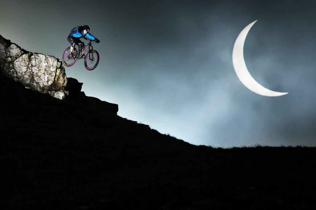
On Friday March 20th a Solar Eclipse plunged Europe into darkness. Photographer Rutger Pauw teamed up with Danny MacAskill to capture the moment on Danny’s homeland, the Isle of Skye in Scotland.
With just one small window of opportunity to get the shot he had dreamed about, Rutger and the team spent days scouring to select the perfect location. This clip gives a unique behind the scenes look at how they found the spot and how they managed to capture one of the most creative shots of the year.
Click PLAY or watch the story behind this photo on YouTube.
(via Adventure Blog)
A friend of Warren Long captured this image. I can’t recall seeing any better from the city.

Thru hiker Carlie Gentry, who works at REI, put together a funny photo essay on the habits and rituals of her kind on the trail – A Scientific Explanation of Hiker Trash (in 25 Images) 🙂


Ross, Jon and Guillermo get together every year for an outdoor adventure. Something they call the annual Pollard Memorial Trip.

For 2014 it was Mt. Shark trailhead near Canmore, Alberta to Assiniboine, Sunshine meadows, Egypt lake, Ball pass, Flow lake, Rockwall and finally the Ottertail river trail to exit near Field, BC.

Check Ross’s trip report and photos – the shultz gambit – Spray lakes to Field with a leaky tent
Guillermo posted a trip report as well:
The GDT runs as close as possible to the continental Divide (the BC/Alberta border) from the US border adjoining Waterton Park to Kakwa Lake some 1200 km north. …
For this trip we chose to hike a popular and well-travelled section in the middle running through two provincial parks and three national parks. …
I had identified this route as a possible solo hike option, but when both Jon and Ross expressed interest, we attempted it in 2013.That summer saw many trails destroyed by spring flooding and later some portions of the Rockwall were closed due to fires and bear problems. In addition, a worrying knee problem which I misdiagnosed as a torn meniscus forced us to abort our hike on the first day. Our 2014 attempt went much more smoothly …
—guillermobarron – The Great Divide Trail: 150 km from Shark Mtn. to Highway 1
Finally, here are Jon’s black and white photos.
(via Hiking in Finland)