MORE photos hiking Tombstone, Yukon

I already posted a trip report with my photos. And a trip video. A spaceman. And related posts.

dave.jpgThen trip leader Dave Hayley mails me a DVD with ALL the photos from our 7 hikers. (Here Dave was either eating Wasabi peas or shooting himself in the face with bear spray. Not sure.)

YEESH.

What could I do?

But browse our hundreds of pics, … and post another 86 HIGHLIGHT photos to flickr, including some personal favourites, some panoramas and even a few celebration shots in Dawson after the hike.

Some examples …

1425765498_821613a918.jpg
chopper into the mountains

1425928836_4a2ba5b2e2.jpg
tent vista

1424822439_4848e6ed70.jpg
coffee time

1425773848_16e4573a28.jpg
drying the socks

1425003497_70773bcc42.jpg
Rick scrambling the ridge

1425841778_6c7e06990e.jpg
farewell … ’til next time

When are we pioneering the Tombstone Circuit, Dave?

View over 86 photos from this trip on flickr. (Click SLIDESHOW.)

original trip report with my own photos.

Tombstone Park – Yukon government

problems hiking the John Muir Trail, California

The JMT is our #2 hike in the World, about 220mi of trail without crossing a road.

I’ve been section hiking it over the past 3yrs. This summer I thought I’d try to knock off about 110 miles.

I brashly announced I’d hike 20mi / day from Bishop Pass to Tuolumne in 6 or 7 days.

1356633232_33f6e81d1e.jpg

It was not to be.

My first mistake was underestimating the difficulty of the required elevation loss and gain. This thing is a roller coaster!

jmt.gif
larger map – PCT.org

I started from South Lake near Bishop after hearing great things about Bishop Pass and Dusy Basin. Both are gorgeous!

1356651710_5ae9e004be.jpg

My favourite section of many favourite sections was Evolution Basin.

1355803357_8e5da75eec.jpg
vista from John Muir Pass to Evolution Basin

But the BIG story of my hike was Hurricane Dean. More exactly, the remnant circulation of Dean which brought serious thunder storms to California and Nevada.

1355811941_c21a14e5c5.jpg
threatening skies

One day I was pinned down in my tent losing 5hrs of daylight. Here’s the hail outside my tent.

hail.jpg

Another morning I awoke early to a cloudy day. A storm climbed up from the valley to pound me. (I hid in low brush to avoid death by lightning.)

storm-morning.jpg

When the storm finally cleared, I had been walking for days in wet socks and shoes. My feet, for the first time in many years, were blistered.

I love the JMT — but had to exit over 30mi earlier than planned, limping out at Red’s Meadow Resort.

1355853995_ba761d9388.jpg

My only complaint with the John Muir Trail is that it’s a horse track.

1355796841_0a55ef4d03.jpg
hiking pack animals

Historically it was pioneered for animals. The trail drops down to valley and water on regular intervals. Animals need grazing. I don’t.

I’d much rather stay HIGH on — for example — the Sierra High Route. This is a mostly off-trail adventure running in parallel with the JMT which tries not to drop down into the valleys.

Check out all my photos from the JMT on flickr.

If you might want to hike it yourself, check our JMT besthike information page.

hike Point Lobos, California mid-September

Another great post by Tom Mangan:

This could well be the best time of the year to drop in on the Point Lobos State Preserve south of Carmel — with lingering summery warmth but just enough of the fog layer remaining to make things interesting.

… Point Lobos tends to be redundantly spectacular — there’s a dozen little coves with swirling water, crashing surf, seagulls riding pieces of driftwood and sea lions barking in the distance — so even hacker with a cheap point-and-shoot can find a few choice images.

I like Tom’s folksy though detailed writing style. And I like his “hacker cheap point-and-shoot” photos even more …

1402604580_798c96f814.jpg

See more … Two-Heel Drive: Point Lobos on a weekday in mid-September

2007 Banff Mountain Photo Competition

In this year’s competition, seventeen winning images were selected from over 2100 submitted by photographers in 27 countries.
Get Outdoors – 2007 Banff Mountain Photo Competition Winners – Getoutdoors.com Outdoor Blog

horsley_paul_lynx-mtn_flora_fauna_500.jpg

All winning photos are posted on the 2007 Banff Mountain Photo page.

4WheelBob’s ascent of White Mtn – photos

The historic ascent by normal wheelchair to the summit of 14,246ft (4342m) White Mountain is old news now.

4WheelBob Coomber made the front page of the San Jose Mercury News.

1285589165_6314187d1b_o.jpg
Mercury News

No doubt, the editors of Backpacker Magazine are kicking themselves they did not send someone to cover his third successful attempt. They had sent a crew on his two previous unsuccessful efforts.

Tom Mangan of the Mercury News and the Two-Heel Drive blog was there. Tom took the photos, captions, wrote the headlines, and even wrote a sidebar piece called Bob wheels to the top, proving me way wrong:

bob-to-summit.jpg
Bob on summit day

bob-crawling.jpg
Bob crawling backwards (which he did 3 times on the final day when the chair could not get past a scree section)

Two-Heel Drive: Favorite images from our White Mountain adventure

The week prior, Tom had invited me to join the support team and I’m glad I did. Bob is an inspiration!

bob-sign.jpg

How hard could it be? Some poor military sods at some distant time in the past were ordered to build a ROAD to the top of a high mountain. Yeesh!

road.jpg

Bob kept reminding over the 3 days ascent that “he couldn’t do it without us”. He’s right. Bob did no more than 97% of the work himself.

It’s much, much tougher than I expected. Much tougher than it looks in this photo. At times Bob could gain only an inch or two for each wheel stroke.

1348626524_4612953600.jpg

It was harsh. A monumental challenge, accomplished.

Congratulations Bob. And thanks.

I posted 50 photos of the climb on flickr.

Torngat Mountains National Park, Labrador, Canada

One of the classiest and best travel photo sites is BluePeak edited by Rogier Gruys.

He is one of the few who have travelled to remote Torngat.

Even better, Rogier created a superb landing page for the Park where the rest of us now have a chance to see that weird, fantastical landscape.

… The Inuit refer to the far northern tip of Labrador as Torngait, the place of the spirits. It is thought that it is the home of Torngarsuak, the Inuit Great Spirit. To outsiders it is known for its deep fiords, the highest mountains east of the rockies, some of the world’s oldest rocks, the only tundra-dwelling population of black bears, and polar bears. Lots of polar bears. …

Access

The park, 9,700 sq.km, is probably one of the most difficult parks in Canada to reach. Even the parks in Nunavut are easier to get to. It’s not only the remoteness, but especially the weather and fericious winds that make getting here an adventure in itself.

If the weather is good, then the park is about 1 hours’ flying or up to two days by fishing boat north of Nain, Labrador’s northernmost community. There are no scheduled flights or boats to the park, and once you arrive, there are no facilities.

Safety is a real concern, as polar bears roam throughout the park. Since only Inuit are allowed to carry arms, visitors should always be accompanied by an Inuit guide. A good idea in any case, as the area is also infamous for its quickly changing weather and strong “ghost” winds that can appear out of nowhere.

Visiting the park

Due to the difficult logistics and its reputation for bad weather, there are currently very few if any organized treks into the park. Nature Trek has led expeditions into the park, but in the future they may only plan occasional treks, due to the extreme logistical challenges involved with organizing them. …

saglek-cliffs.jpg

north-arm.jpg

more photos – Torngat Mountains National Park – Rogier Gruys

Ace The Himalaya photos

Great photos hiking in the highest mountains in the world.

Here’s a sample:

chomolhari.JPG
Chomolhari Trek, Bhutan – more photos

An expensive guided trek to Bhutan would be great. But when will that country finally open to independent hikers?

I’d love to get to Bhutan myself the first year it opens.

hike trip report – Tombstone Range, Yukon

by BestHike editor Rick McCharles

I first heard of the Tombstone Mountains in 1999 from contributor Kelly Mock. It remained in my mind a magical,  mythical hiking destination until this summer.

There are a number of ways to hike Tombstone. The best is to chopper in, hike out. At $20 / minute of flight time, we each paid over $200 for the flight.

1122625055_1dccd530a6_b

Bad weather prevented us from landing where trip leader Dave Hayley intended, a high Cirque.

That turned out to be fortunate as the off-trail bushwhacking was much more difficult and slow than we expected. We quickly grew to hate Arctic Willow and Alder. In fact, we were forced to wild camp our second night well short of our intended destination, Talus Lake.

Tombstone

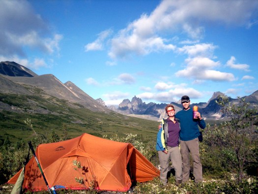
This was a bit of a hiking honeymoon for Dana and Bill who had been married just a few weeks earlier.

1123489032_f704d575ab_b

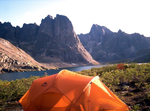
To get back on schedule, we bypassed Talus and continued to the Divide Lake campground

1122679925_70d3b4cff1_b

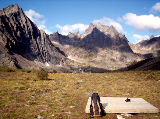
Dave Hayley was shocked to see new tent pads and toilets. In 5 previous trips to Tombstone he had never seen even a single other hiker.

The secret is out. It became a Territorial Park in 2004. Tombstone is now on the radar of northern hikers.

The crux of our hike was this Pass.

1123551082_26c1c3bb1a_b

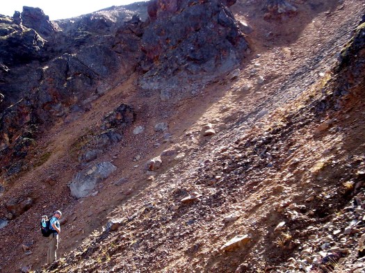
Bill carried an ice axe for our group as we expected the Pass to require some step cutting. But for some reason — there was very little snow on the Pass this August.

Hayley found the loose scree at the top of the Pass to be more dangerous and difficult than his past snow ascents.

Grizzly Lake campground is just as lovely as Talus and Divide.

1123584924_905a876c76_b

After 5 days, 4 nights, our happy band of survivors walked out to Dempster Highway in about 6 hours. This is the closest access to the road for those who do not come in by helicopter.

Thanks to organizer Dave Hayley. This is his favourite place in the world. And one of mine too.

View over 125 photos from this trip on flickr.

Tombstone Park – Yukon government

Patagonia or Yukon?

Where are these photos from?

Patagonia in South America?

Or the Yukon in Canada?

granite-1.jpg

granite-2.jpg

While hiking in the Tombstone range of the Ogilvie Mountains in the Yukon I was struck at how similar were those mountains to Paine and Fitz Roy in Patagonia.

In fact, I came to call Tombstone the “Patagonia of the North”.

The first photo is Yukon, the second Patagonia.