trek Akshayuk Pass, Baffin Island

The Adventure Addict posted a great series of annotated photos of their trek south to the Arctic Circle.

akshayuk.jpg

Wow! I’ve never hiked that far North. (If only I could afford to fly to Pangnirtung. And on to Qikiqtarjuaq.)

You can’t really see from the pic, but the vertical part of the face is actually overhanging at 105°. This mountain has the longest vertical uninterrupted face on Earth, and is a mecca for climbers and B.A.S.E. jumpers. The vertical part is 1250m tall — yes, that’s 1.25 KILOMETRES tall. …

thor-peak.JPG
Thor Peak – flickr

Auyuittuq National Park, Baffin Island, Nunavut, Canada. 6 intrepid/crazy hikers go for a 9 day hike in a remote, mountainous landscape in the Canadian arctic.

Akshayuk Pass hike, Auyuittuq National Park, Canada – a photoset on Flickr

thor.jpg
Breadablik and Thor

Interested? Check an even better trip report with photos by Nestor and Lewycky.

More information:

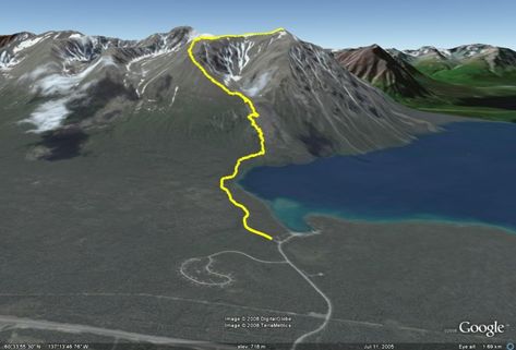
Baffin Island. The Akshayuk Pass, formerly known as Pangnirtung Pass, is an extraordinary 100-km trek through a land recently vacated by glaciers – though they line the edges of the valley and send fingers of ice creeping into the edges of it. Mountains over 2000 metres high line a route through the finest scenery in North America. In 2004 Outside Magazine voted the Auyuittuq Backpacking trip one of the top “Trips Of A Lifetime”.

source

Friends are looking at Akshayuk for the summer of 2009. Leave a comment if you have deep pockets and might be interested in joining us. If bears scare you, we’ll need a gun. A bigger concern, actually, is drowning or death by hypothermia after river crossings.

Obviously Akshayuk is included on our list of the best hikes in North America.

climb Kala Patthar – see Mt Everest

Matsamuel posted an excellent trip report of his trek to Everest — actually to the summit of Kala Patthar near Everest. Ideal reading for anyone considering that trip.

Unfortunately he posted it on the confusing cluttered Travelpod website. (Actually, that site is very functional.)

Best starting point on Travelpod is his table of contents.

Or jump directly to the highlight of the trek — Everest Trek Day 10, Loboche to Kala Patthar:

… I have to admit I was a bit worried about climbing Kala Patthar. Yesterday, as we were trekking to Loboche, Noori pointed at a mountain in the distance and simply stated “Kala Patthar”. …. That’s Kala Patthar?! How the heck were we going to climb that? It looks sheer on all sides and the fact that the top is covered in a layer of ice is not easing my mind. We don’t have any equipment to make that sort of technical climb let alone the know-how or the guts.

kala-patthar.jpg
photo source

… the top of Kala Patthar was in view and it was close. It was a real scramble across rocks upon nearing the summit but finally I had made it. I turned around to see Everest under a perfect sky. After 10 days of trekking I had made it to the top of Kala Patthar and was gazing at what is arguably the best ground view of Everest possible. That was my reward. It is just a magnificent mountain to look at. Stark black with hardly much snow with its classic triangular shape. It truly is a natural wonder. I could have stayed up there all day if it was for the fact that I was truly freezing my ass off. …

nepal_20071197034200pc070340.jpg
photo source

…Everest, the king of all mountains, right in front of me. I was hard to believe that I was seeing all this live and with my own eyes.

Everest Trek Day 10: Loboche to Kala Patthar
– trip report

His trekking partner Mazen was sticken with severe altitude sickness and did not try for this summit. They descended as quickly as possible.

Stories like this make me want to trek at lower elevations. The heavily glaciated peaks of New Zealand or Patagonia, for example, which have almost no risk of altitude sickness.

Kala Patthar – 5545m (18,192ft) – Wikipedia

off-road motor vehicles vs hikers in Utah

I spent 2wks last year hiking out of Moab, Utah. Then got grief after criticizing the ethos of the “adventure destination” in this post: Moab, Utah – living a lie?

Comments like this offended:

Moab reminds me more of Mad Max than a desert oasis.

That town is a hub and a flash point for the off-road vehicle debate.
Two rangers are charged with policing 1.8 million acres of Utah wilderness. How well is that working, do you think?

off-road-vehicle-utah.jpg

This issue has finally hit the popular media. Most importantly in a series of New York Times articles including this one: Surge in Off-Roading Stirs Dust and Debate in West

Now in an accompanying video. Click here to watch it.

Personally, I vote to confine motor vehicles to the smallest geographic area possible. And to restrict jeeps and Hummers foremost as they cause far more damage than, by comparison, snowmobiles.

AND I would start in Moab, Utah. That town has it’s priorities wrong. It’s time to force the issue.

(via GOAT)

Related post: motorized vehicles ruin the Utah desert

motorized vehicles ruin the Utah desert

WildeBeat audio journal did a great piece this Fall on the problems of off road vehicles in the Utah desert.

This wild places program examines the problems of trying to designate new wilderness areas in the central Utah desert. If it gets overrun by off road vehicles, can it still become new wilderness?

This story was provided to us by guest reporter Kurt Repanshek, creator of the National Parks Traveler web magazine. Kurt tells this story of the struggle for wilderness designations in the desert canyonlands of central Utah with the help of:

* Heidi McIntosh, conservation director for the Southern Utah Wilderness Alliance
* Wayne Ludington, assistant field manager for the Price district of the Bureau of Land Management
* Liz Thomas, attorney for the Moab office of the Southern Utah Wilderness Alliance

(A spokesman for the Blue Ribbon Coalition, the dominant advocacy group for off road vehicle enthusiasts, didn’t respond to our e-mailed requests for an interview.)

The WildeBeat: The audio journal about getting into the wilderness.

off-road-vehicles-utah.jpg
Southern Utah Wilderness Alliance

What a shame.

We named the SW USA the #2 best region in the world for hikers. But seeing motorized vehicles welcomed into Canyonlands National Park is a huge downer.

Alaska Brooks Range Traverse

Alaska wilderness guru Buck Nelson in 2006 made an incredible solo journey. Maximum pack weight was about 43 pounds.

He’s made a 90min documentary of that adventure.

My trip started June 18 at the border of the Yukon Territory and ended September 2nd at the ocean near Kotzebue.

alaska_map.jpg

The final mileage of my trip worked out to be an estimated 1,050 miles. 600 of those miles I covered while backpacking, with about 450 more miles covered on the Noatak River.

I made countless crossings of small streams. The vast majority of these crossings were in very shallow water where I just waded across quickly in my lightweight Goretex lined boots, which usually kept my feet dry. For slightly deeper water, I “bloused” my rain pants tightly around the tops of my boots with rubber bands and crossed the shallowest spots as quickly as possible. This was also quite successful, depending on how deep the water was and how fast I crossed. At other times I just had to get wet and waded rivers thigh deep or more. On the Alatna, I made a raft for the crossing.

I had grizzlies run towards me at least three times. In each case they ran as soon as they smelled me. (Presumably, they thought I was a caribou or moose at first.) I had bears walk into my camp at “night” about three more times. Again, each time they ran when they smelled me. I didn’t lose any sleep due to grizzly bear concerns.

The mosquitoes were thick at times, but my long-sleeved shirt and pants were both mosquito proof, and along with repellant as necessary it wasn’t too bad. A lot of the time when it was breezy or cool there were few or no mosquitos around.

The toughest unexpected part of the trip was perhaps the unusual amount of rain during the summer of 2006. The toughest part of the hike that I’d anticipated was the rough walking along many stretches.

I followed river and creek drainages that ran east-west along the Continental Divide as much as possible.

Alaska Brooks Range Traverse

A video preview featuring many of the animals encountered:

Alone Across Alaska from bucktrack.com on Vimeo.

Alone Across Alaska: 1,000 Miles of Wilderness – (DVD) $24.95

(via American Hiking Society)

tips to make a good hiking trip, great

In the cold Canadian winter, the only hiking I can do is on-line. I’m dreaming of warmer weather.

On one of my favourite hiking sites (out of Australia), Frank posted this advice:

What do you need to prepare for a multiday hike so you have a great time and enjoy the outdoors? We have put together a “Top 7” list of ideas we always use whenever we head out into the bush.

Now the list, in no particular order……..

1) Good food …

2) Good companion(s) …

3) Know your route and expected hiking times …

4) Light weight …

5) Comfortable boots …

6) Let someone know where you are going and when you will be back …

7) Take shared gear

Our Hiking Blog: 7 tips to make a good hiking trip, great

Another good, original checklist was posted by Tom Mangan. Essentials for dayhiking:

1. NAVIGATION.
2. SUN PROTECTION.
3. INSULATION.
4. ILLUMINATION.
5. FIRST-AID SUPPLIES.
6. FIRE.
7. REPAIR KIT AND TOOLS.
8. NUTRITION.
9. HYDRATION.
10. EMERGENCY SHELTER.

The real 10 Essentials – Two-Heel Drive

Tom neglected to include a product I got as a Christmas from Garth: TowTabs.

Simply add water to a “tablet” … and it turns into quite a good towlet!

12227bb.jpg

details – TowTabs

#5 best hiking region in the world is the …

Central Andes

Ecuador, Peru and Bolivia

Hiking holidays in Peru are hot right now. More popular than ever. Political stability since the leader of the Shining Path terrorist group was captured in 1992 resulted in a booming tourist industry.

The second highest mountain range on Earth is fantastic. Broad valleys and endless vistas. You are always above the tree line. Arid desert to the west, Amazon jungle to the east.

Our contributors have hiked most of the major treks in Peru the past few years. The peaks, glaciers and canyons are outrageous. Everyone is thrilled with the Andes.

Unfortunately, management of treks is atrocious, the Peruvian government seemingly bent on ruining their fantastic tourist draw. Do your homework before booking a flight to Lima. Or sign on with a trekking company with which you have had a strong, recent recommendation.

Ruminahui in Cotopaxi National Park, Ecuador

The weather in the Andes can be deadly, of course, but sometimes you get weeks of sunny blue skies, especially in the Cordillera Blanca out of Huaraz, Peru. The best weather for the high peaks out of Huaraz (the best jumping off point for hikers in the Central Andes) is the drier “Andean summer”: May-Sept.

In fact, there are good hikes somewhere in this region year round.

More information on our new Central Andes information page.

Our favourite hike in the Central Andes is the little known Ausangate Circuit in Peru, our #4 best hike in the world. Quite a few trekkers have decided on Ausangate (instead of the over-hyped Inca Trail) based on our recommendation. And all have been happy with that decision.

See our Ausangate Circuit Information page.

The best guidebook for the Central Andes, by far, is Lonely Planet:

Lonely Planet Trekking in the Central Andes

Lonely Planet Trekking in the Central Andes

Note that Bolivia is not nearly as popular as it should be due to lack of infrastructure for tourism, security concerns and political instability. Honestly, unless you know the language and culture well, it’s better to hike Peru. Or much neglected Ecuador.

scramble the King’s Throne, Yukon

From some angles the King’s Throne looks like a King’s Throne, hence the name. It’s an easy climb or a tough scramble.

10km (6.2mi) in distance to the summit, about 6hrs return, moderately strenuous.

You have the choice of a 457m (1500ft) climb to rock glacier. Or — if conditions are good  — continue to the top, total ascent being 1,250-metre (4,100-foot) above the lake.  

The views are spectacular all the way up, so there’s no need to top out. Especially if it’s windy or you get “weather”.

You need to find transport to the Kathleen Lake campground 32km (20mi) south of Haines Junction, Yukon. We stayed there one night after our descent.

YukonHiking.ca

You will not feel rushed during the long days of the northern summer. It was light out until perhaps midnight when we were there.

Kluane National Park Hiking Guide

Kluane National Park Hiking Guide

Atop the King’s Throne you’ll be inspired to adventure deeper into this, the largest protected area of the world. But there are very few established trails. You’ll likely be bushwhacking. Or paddling.

Contributor Kelly Mock from Whitehorse suggests (instead) a spring ski tour of the most famous long trail in the park, Cottonwood.


Hurricane Ridge Road in Olympic National Park Closed Due to Storm Erosion | National Parks Traveler

A year and a month after a Pacific storm battered Olympic National Park, another storm pounded the park Dec. 3, washing out portions of the Hoh Road.

olym-hoh-rd-damage-12-03-7.jpg

Hurricane Ridge Road in Olympic National Park Closed Due to Storm Erosion | National Parks Traveler

So far, this winter is starting out like last year in terms of damage to the Pacific North West Parks. Too bad.

toughest long distance walk in the British Isles

So says the Ramblers Association.

Cape Wrath Trail is a hiking route that runs through the Scottish Highlands and along the west coast of Scotland.

It is approximately 200 miles in length and is considered to be one of the most challenging long distance walks in the UK.

The trek gained prominence via a 1996 book by Dave Paterson entitled The Cape Wrath Trail. This was followed in 1999 by a separate publication (North to the Cape: A trek from Fort William to Cape Wrath) by Denis Brook and Phil Hinchliffe.

In both versions the trail begins in Fort William and ends at Cape Wrath lighthouse on the northwest tip of the Scottish mainland. It connects with the West Highland Way and parts of it also follow the Great Glen Way to Inverness.

These guidebooks estimate an experienced hiker should be able to traverse the entire route in less than 20 days. However the two sets of authors detail slightly different routes and stages for hikers to follow.

Officially the trail is not endorsed by Scottish Natural Heritage and it is not waymarked or signposted. Facilities along the trail are also minimal and it covers some of the remotest parts of mainland Britain. …

Cape Wrath Trail – Wikipedia, the free encyclopedia

cape-wrath.jpg

Check a superb trip report by Colm Ennis.

North to the Cape (Cicerone Guide)

North to the Cape (Cicerone Guide)

DISCOVERING THE CAPE WRATH TRAIL. A JOURNEY OF 200 MILES FOLLOWING SCOTLANDS ANCIENT FOOTPATH FROM FORT WILLIAM TO CAPE WRATH

A Walk Through the Highlands of Scotland: DISCOVERING THE CAPE WRATH TRAIL. A JOURNEY OF 200 MILES FOLLOWING SCOTLANDS ANCIENT FOOTPATH FROM FORT WILLIAM TO CAPE WRATH

We’ve added Cape Wrath to our list of the best hikes in Europe.