BestHike – The Wave, Arizona USA

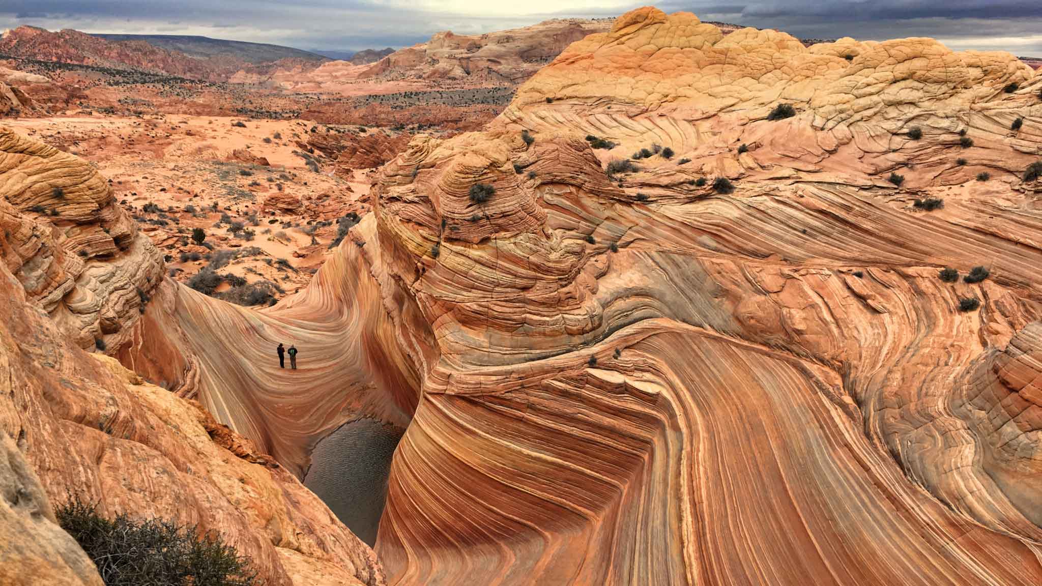
One of our top 10 day hikes in the world.

Only 20 hikers / day are allowed access. The BLM is considering an increase to a maximum of 96 per day .

Getting a permit is the BIG problem.

  • on the Utah-Arizona border, halfway between Page, Arizona and Kanab, Utah in the Paria Canyon/Vermilion Cliffs Wilderness
  • in 2014 about 50,000 applied for permits. Only 15% were granted.
  • Wire Pass trailhead located in North Coyote Buttes permit area of the Vermilion Cliffs National Monument
  •  5.2 miles return
  • you can go any month of the year, if you can tolerate the heat

World → North AmericaS.W. USA  → Arizona → The Wave

For details click over to our Wave information page.

Knox Mountain via Apex Trail, Kelowna, Canada

Visiting friends in Kelowna, I saw the Apex Trail listed #1 for the city on AllTrails.

  • 4.2km return
  • 267m elevation gain

It is super popular with walkers, runners, and mountain bike cyclists.

My friends there walk trails on Knox Mountain every day of the year.

Steep trails lead to great views of both Kelowna and Okanagan lake.

Check the official website.

Southern Utah Traverse – 800 miles

Epic.

The world’s greatest living hiker, Cam Honan, along with Kate “Swept Away” Pickett, put together a route from Nevada to Colorado across Utah.

Highlights

  • Snow Canyon
  • Red Mountain Wilderness
  • Gooseberry Mesa
  • Canaan Mountain Wilderness
  • The Barracks
  • Great Chamber
  • Bryce Canyon NP – Under the Rim Trail, Peekaboo Loop, and Fairyland Loop.
  • Powell Point
  • Death Hollow
  • Egg Canyon
  • Upper and Lower Muley Twist Canyons
  • Cliff Point on the Waterpocket Fold
  • Stevens Canyon
  • Fold Canyon
  • Coyote Gulch
  • The Lizard Route out of Halls Creek
  • Grand Gulch and Bullet Canyon
  • Comb Ridge
  • Hovenweep National Monument

… a combination of cross country travel, 4WD tracks, rock scrambles, river wading, dirt roads, established trails, and a minimal amount on pavement. More often than not, directional choices were dictated out of geological and historical curiosity …

water was one of the primary considerations when planning the trip. …

resupply a combination of mail drops and buying as we went …

Along with the America the Beautiful Entrance Pass, overnight camping permits were required for Bryce Canyon National Park, Grand Staircase/Escalante National Monument, Capitol Reef National Park, and Bears Ears National Monument.

Southern Utah Traverse: An 800 Mile Hike from Nevada to Colorado

Top 10 Hiking Destinations ➙ Australia

We love Australia. Who doesn’t? What’s not to like? It’s paradise Down Under.

What an exotic treat to have kangaroos and wallabies hanging about your campsite!

A.I. generated image

“Stunning rocky headlands and perfect beaches, lush rainforests, sun-sharpened deserts and the muted beauty of the bush waking to the trail in Australia offers a kaleidoscope of colours, terrains and adventures for walkers of all levels.” – LP

You have such a wealth of choices: the Blue Mountains (NSW), Whitsunday Islands (QLD), dense subtropical rainforest in Lamington National Park (QLD), Larapinta Trail (NT) out of Alice Springs, wild Kakadu National Park (NT), the rugged Cape-to-Cape (WA) or pretty Wine Glass Bay in Freycinet National Park (TAS).

More information on our Australia information page.

Our favourite hike in Australia is The Overland Track in Tasmania.

See our Overland Track Information page.

Zion Traverse, Utah

Quick Facts

  • Distance: 48.3 miles (77.7 km) Lee Pass to East Rim / 37 miles (60 km) Lee Pass to The Grotto
  • Days Needed: 1-5 days
  • Peak Elevation: 7,441 feet
  • Low Elevation: 4, 327’
  • Elevation Gain/Loss:6,334’ ascent and -6,646’ descent
  • Best Travel Time: April-May or September-October
  • Permits: Required (see below)
  • Difficulty: Moderate-Difficult

… The Zion Traverse, also called the Trans-Zion Trek, is not a single trail but a group of trails linked together …

This is a stunning maze-like landscape of steep echoing canyons, soaring Navajo sandstone monoliths, and high plateaus. Every possible place where flora can grip the earth is packed with pine and juniper, high-desert flowers, sipping from seeps, springs, or making the most of a bit of rainfall. This is a fascinating geological journey that will ignite a love for desert wildernesses.

One of the national park’s more logistically complicated hiking options, the Zion Traverse offers many rewards for the effort …

Clever Hiker – Zion Traverse Backpacking Guide

Superb Hiking Town – Moab, Utah

Moab is a fantastic jumping off point for outdoor adventure, a special mecca for crack climbing.

Click PLAY or watch it on YouTube.

But the “strip” can be loud, ugly, hot and aggravating. Once you get away from the highway, the town’s much prettier. They have a good library and great bike trails.

Moab … in eastern Utah … is 233 miles (374 km) southeast of Salt Lake City and 354 miles (569 km) west of Denver, Colorado …

The population was 4,779 at the 2000 census. … Moab hosts a large number of tourists every year, mostly visitors of the Arches and Canyonlands National Parks, which are located close by. The town is also a popular base for mountain bikers who come to ride the extensive network of trails including the famed Slickrock Trail

More interesting photos tagged Moab, Utah.

Arch in the Mountain, Utah

Our favourite hikes out of Moab are:

• Chesler Park
• Devil’s Garden
Delicate Arch
Syncline Loop
Upper Salt Creek
• Murphy Basin
• Gooseberry-Dogleg Loop

There are many, many more. This is Edward Abbey country.

Chesler Park

Click through for more “best hikes” in the S.W. USA.

Hike here Spring and Fall. It’s HOT in the summer.

We got back to Moab in 2024 — with 30 people! Great fun.

Click PLAY or watch it on YouTube.

Hiking Wonderwall & Wonderland, UAE

If you get to Dubai in the United Arab Emirates, consider heading out to the Western Hajar Mountains, which run alongside the border with Oman.

Perhaps the BEST hike / scramble is Wonderwall & Wonderland.

Others include:

  • White Wadi
  • Jabal Jais southside
  • Leopard Canyon

Add on abseiling, if you sign on with Adventurati guides.

Click PLAY or watch it on YouTube.

Visiting the Hoggar Mountains in Algeria

Fantastic hiking, cycling, and climbing — but complicated and difficult to reach.

The Hoggar Mountains (Arabic: جبال هقار (Ǧibāl Haqqār), Berberidurar n Ahaggar) are a highland region in the central Sahara in southern Algeria, along the Tropic of Cancer. …

… home to the Ahaggar National Park

The area is largely rocky desert with an average elevation of more than 900 m (3,000 ft) above sea level. The highest peak, Mount Tahat, is at 2,908 m (9,541 ft). …

The jumping off point is the city of Tamanrasset, population about population of 93,000.

Visit during the cooler months.

Click PLAY or watch it on YouTube.

3,000-Mile Divide to Crest Thru Hike

Lyla Harrod is a super experienced thru hiker.

The first trans woman to complete the Triple Crown in 2023, set out to INVENT a new even more difficult challenge.

She calls it the Divide to Crest.

You’re not likely to cross paths with trail name Sugar because this route is so remote, so difficult.

Two trails piqued Harrod’s desert hiking interest: The 500-mile Mogollon Rim Trail in Arizona and the 750-mile Oregon Desert Trail. She wondered if she could somehow connect them. …

… Nevada’s Basin and Range Trail proved to be the missing piece. The 1,090-mile route through eastern and central Nevada allowed Harrod to begin planning her diagonal traverse from the barren deserts of New Mexico to the glacial peaks of Washington. …

Backpacker – Lyla Harrod’s 3,000-Mile Divide to Crest Route Might Be the Wildest New Thru-Hike in America

10 days Solo – Larapinta Trail, Australia

Laura Waddell had a terrific adventure in May.

The Larapinta Trail is an extended walking track in the Northern Territory of Australia. Its total length covers 223 kilometres (139 mi) from east to west, with the eastern end at Alice Springs and the western end at Mount Sonder, one of the territory’s highest mountains. It follows the West MacDonnell Ranges, sometimes along the ridge line, other times on the plain below, in the West MacDonnell National Park. …

During the summer months, temperatures along the trail can exceed 45 °C (113 °F) leading to risk of heatstroke and dehydration. Most people walk the trail during winter when the days are cooler.

Click PLAY or watch it on YouTube. (25min)