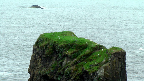
scrambling Mt Remus, Alberta

Great day.

Evidence we made the summit – Amber writing us up in the summit log.

summit log

Of our group of five hikers, three were gymnasts. Here’s Krista celebrating the summit.

Krista - handstand - Remus summit
_____

We cycled in 6.5km (4mi), then had trouble finding the small cairn marking the start of the rough path to the river crossing. Our experience was exactly that posted on peakware:

Description – by Dow Williams:

Mount Remus is part of the horseshoe shaped Fisher Range at the front end of Kananaskis Country in the Elbow-Sheep Wildland Provincial Park.

Kananaskis Country is a maze of provincial parks which encompasses over 4,000 square kilometers of foothills and mountains bordering Banff National Park in the central Canadian Rockies.

Mount Remus starts one end of the horseshoe and Mount Fullerton the other. In between lies Mount Romulus and Fisher Peak. Mount Remus was officially named in 1940 along with Mount Romulus after the legendary twin brothers and founders of Rome.

Remus summit

The only published route up Mount Remus is the moderate to difficult scramble up its eastern slopes to its summit block. The guide book determines the chimney up the center of the summit block to be difficult with an optional moderate approach from the north. I found the chimney did not present a difficult challenge and rate this scramble moderate at most.

IMGA0718.JPG

The most challenging aspect of the day involves crossing the Little Elbow River. This aspect of the trip more than likely explains why there is no trail and few, if any, cairns, thus little evidence of any traffic up this mountain. …

read more on peakware

IMGA0664.JPG

IMGA0669.JPG

Most fun was screeing and glissading descents. Here’s my butt track after I discovered tobogganing was even easier.

IMGA0747.JPG

more photos from this great day hike

related post – biking hiking Banded Peak, Alberta
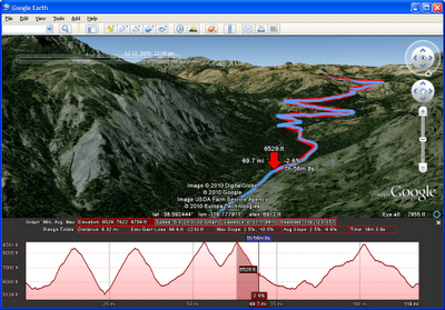
Google Earth: Hiker’s Edition

That’s what Erick Schonfeld of TechCrunch is calling it.

… Google Earth released a new edition of its desktop app which hikers, runners and cyclists are going to love. They call it Google Earth 5.2. I call it the Hiker’s Edition.

One of the new features allows you to recreate the path of a hike or bike ride by ingesting geo-data from one of your GPS devices. The visualizations show you the speed, elevation, and other stats from your hike, which you can see as an animation inside Google Earth. …

read more on TechCrunch

This video features an example of the new track feature in Google Earth 5.2, showing a bike route to work. Download the latest version of Google Earth

Click PLAY or watch it on YouTube.

hiking Boardman Park, Oregon

trip report by site editor Rick McCharles

Astonishingly, Oregon has kept it’s coastline mostly undeveloped.

… 1967’s Oregon Beach Bill allows free beach access to everyone. This Bill allows private beach landowners to retain certain beach land rights, but it removes the property tax obligation of the beach landowner. In exchange, the beach landowner grants an easement passage to pedestrians. …

Wikipedia

But where’s the best place to hike that pristine coast?

hiking Boardman State Park, Oregon

For some reason the authors of Lonely Planet HIking USA directed me to Samuel H. Boardman State Scenic Corridor, close to the California border:

Dramatic sea-stacks, arches and offshore islands seen on this short, down-and-back day hike … are one of Oregon’s best kept secrets …

5.4mi (8.87km)

I drove to the Arch Rock trailhead, locking up my mountain bike to a railing. …


larger map (PDF)

… Then drove to the Natural Bridges trailhead to start the hike.

It is gorgeous. Here are a couple of the many “natural bridges”.

Natural Bridges Cove - Boardman State Park, Oregon

hiking Boardman State Park, Oregon

This “hike” is a series of steeply dropping trails that then backtrack up to the highway. You might drop down to see a secluded beach …

hiking Boardman State Park, Oregon

… or a minor waterfall.

waterfall - Boardman State Park, Oregon

The lush vegetation I liked.

hiking Boardman State Park, Oregon

But the trail itself sometimes returns all the way to paved highway! Dislike.

hiking Boardman State Park, Oregon

I’d not call this a best hike. For once Lonely Planet gets it wrong.

The strategy for Boardman is to drive (or cycle) to each trailhead in series. Then hike down and back each.

I’m still looking for the best long section of the mythical Oregon Coast Trail. Leave a comment if you have advice.

near Valley of Fire, Nevada

trip report by editor Rick McCharles

I set up camp here …

near Valley of Fire, Nevada

Hopped on my mountain bike, heading for the hills.

Civilization? A long abandoned dam:

near Valley of Fire, Nevada

I jumped off my bike upon reaching this rock formation, perfect for scrambling.

Summit Stone is atop the highest point of this formation.

Atop the highest point, this guy, seemingly a madman, placed a Summit Stone. Will anyone ever find it?

Rick with Summit Stone

What a terrific outdoor adventure. No hiking guidebook needed.

Rick - near Valley of Fire, Nevada

Adventure Sports Week LOOMS

I’m looking forward to the second annual ASW. Will you be there?

2010 Dates June 4-13

Each June in Northern Idaho, Adventure Sports Week offers 10 days of racing, training, clinics, gear demos and more. ASW features triathlons, mountain biking, trail running, adventure racing, open water kayaking and swimming.

Our venue is located on the shores of Lake Pend Oreille at Farragut State Park.

home page

• Schedule of Races

• Registration

• Venue

biking/hiking Red Rock Canyon, Vegas

My favourite attraction in Las Vegas is Red Rock Canyon, perhaps the best hiking and scrambling destination in the world this close to a major city.

It’s super popular with road bikes, too. I was out-of-place on the 13mi (21km) scenic loop drive … on a mountain bike.

Rick cycling Red Rock Canyon, Las Vegas

There is no off trail biking allowed at Red Rock.

My first stop was the new Visitor’s Center. Impressive.

From there I road on to the Calico Tanks trailhead:

… fairly strenuous, 1.2-mile hike and scramble runs up a canyon and over sandstone slickrock to a large natural depression (a tank or tinaja) near the top of the Calico Hills ridge. The tank sometimes holds water. There are great views of Calico Basin and the Las Vegas valley from a saddle just beyond the tank. …

Bird and Hike

Calico Tanks hike - Red Rock Canyon, Las Vegas

The trail is not well signed nor defined. But at the Visitor Center it was explained to me …

Follow the obvious trail. When that runs out, look for stone steps.

stone steps - Red Rock Canyon, Las Vegas

When there is no trail and no steps, scramble up the easiest way you can find. Until the next section of trail. Or steps.

Finally you reach the largest “tank” itself.

Calico Tanks hike - Red Rock Canyon, Las Vegas

Five minutes higher and you just might be able to eye your Casino hotel in the distance.

Red Rock Canyon, Las Vegas

See the rest of my photos.

The hiking’s fine at Red Rock. But, for me, the best activity is rock scrambling.

biking to Hoover Dam

trip report by site editor, Rick McCharles

In 1931 a railway was built, 30mi connecting Boulder City with the Hoover Dam used to transport construction materials.

Today hikers and bikers can enjoy a Rails to Trails path along those former tracks.

I certainly did.

Rick cycling Hoover Dam, Nevada

There are spectacular views over Lake Mead.

cycling Hoover Dam, Nevada

The highlight is a series of tunnels.

cycling Hoover Dam, Nevada

You might read that the trail dead ends after the last rail tunnel, for security reasons. Not so when I was there April 2010. I continued riding all the way to the parking lot for the Hoover Dam tour.

My most vivid memory of the morning is bad signage. The National Parks are so broke and disorganized, that there is no obvious sign where you should turn left towards the Lake Mead National Recreation Area when driving from Boulder City.

More evidence that governments cannot do anything efficiently.

The Hoover Dam is 30mi (48km) southeast of Las Vegas, Nevada.

Adventure Sports Week June 4-13, 2010

by site editor Rick McCharles

Each June in Northern Idaho, Adventure Sports Week offers 10 days of racing, training, clinics, gear demos and more. ASW features triathlons, mountain biking, trail running, adventure racing, open water kayaking and swimming.

2009 was our inaugural year and we’re gearing up for 2010. One of the best new adventure sport races in the U.S.A.

details and registration is available at www.adventuresportsweek.com

What do rollercoasters, a great rappel, fantastic scenery, a first class event and “10-24-1” have in common?

Adventure Sports Week 2009

Hosted at beautiful Farragut State Park in Bayview, Idaho (just north of Coeur d Alene), ASW 2010 is promising to be one of the top festivals in the USA this year.

• official event home page

Team Adventure Sports Week blog

cycling Twin Tunnels Trail, Oregon

by site editor Rick McCharles

At tourist information in the Columbia River Gorge, I picked up a brochure called Columbia River Gorge Bike Map.

It’s geared for road bikes, unfortunately.

I had a mountain bike and was looking for off-road. Though nearby Portland is considered one of the best cycling cities in the States, dedicated bike trails are NOT abundant in the Gorge.

Further research led me to these best 2 options:

1. Klickitat Trail (Rails to Trails)
2. Twin Tunnels (old highway)

I drove out early evening to check Klickitat. Looked cool. But, in the end, I chose the other (shorter) option, Twin Tunnels from Hood River to Mosier, and beyond.

biking Twin Tunnels Trail, Oregon

The old road runs parallel and above the new highway.

biking Twin Tunnels Trail, Oregon

Loved it.

biking Twin Tunnels Trail, Oregon

I’ll do Klickitat next time.

I stayed across the river in Bingen at the Columbia River Gorge hostel, one of the most unique I’ve ever seen. It’s a former school, closed for decades.

biking Twin Tunnels Trail, Oregon

related – Columbia Gorge magazine.