hiking Cerro Chato, Costa Rica

trip report by site editor Rick McCharles

Chato Volcano, sometimes called “Cerro Chato” (Spanish for “Mount Chato”), is an inactive volcano in north-western Costa Rica …

It is southeast of the nearby Arenal Volcano …

A crater about 500 metres (1,600 ft) wide is filled with a lagoon, Laguna Cerro Chato. …

Chato hike map

Since I hate taxis, I instead walked the 3.5km from La Fortuna town to Cerro Chato Eco Lodge.

map-cerro

Paid $12 for the hike. And $4 for two Diet Cokes. (One of the ’10 essentials’ of hiking.)

IMG_3159

Many tourists feel prices are too high in the Arenal area. I agree.

The weather looked bad. Normal for the rainy season here.

IMG_3169

Still, I was psyched. I love climbing volcanos.

IMG_3168 (1)

There were some views.

Arenal town
Arenal town

You have to get lucky to see animals on popular trails here. I saw only birds.

IMG_3179

And cows. There are plenty of cows.

IMG_3184

It’s steep in parts. Muddy. You must scramble tree roots.

Everyone gets sweaty, regardless of their fitness. It’s hard work in a humid environment.

I stopped at the volcano rim, however, when two hikers told me they had given up on the steep, muddy descent to the water. ’Sketchy’, they warned.

We agreed that there was not much to be seen down there, in any case, as the summit was cloud covered.

After hiking down quickly, I ran some of the 3.5km downhill back to my hostel. A big day, all-in-all. My celebration meal was Calzone. I was hungry. 🙂

more photos

related – Trip Advisor – Cerro Chato

Monteverde Cloud Forest Reserve, Costa Rica

trip report by site editor Rick McCharles

DSCN0115

The highlight was seeing 2 resplendent quetzal. Another Canadian saw 4 the same day. May is breeding season.

440px-Quetzal01

… The “song” is a treble syllable described as kyow or like “a whimpering pup”, often in pairs, which may be repeated monotonously. …

It was something closer to a puppy whimper than a kitten’s sound.

… classified as near threatened on the IUCN Red List due to habitat loss. …

The Monteverde Cloud Forest Reserve (Reserva Biológica Bosque Nuboso Monteverde) … founded in 1972 … visited by roughly 70,000 visitors a year. …

… extremely high biodiversity, consisting of over 2,500 plant species (including the most orchid species in a single place), 100 species of mammals, 400 bird species, 120 reptilian and amphibian species, and thousands of insects, has drawn scientists and tourists since. …

I hiked all the trails in less than 4 hours. A number were closed. They looked to me to be closed permanently.

trail map

I did take one of the closed trails for a few hundred metres, just to compare. It seemed about the same but without trail maintenance.

IMG_2954

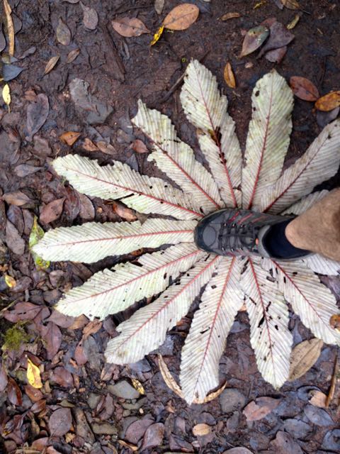
For lunch I propped myself up against my pack under a giant tree. And enjoyed it so much that I left behind a Summit Stone.

IMG_3004

A second highlight was the bridge through and above the forest canopy. Dangling plants living only on “air” are amazing.

click for larger version

Cost for entry in 2015 was $20 for a foreign adult. Locals consider that high compared to a similar experience in the other reserves.

On the other hand, this is the only official local hiking area that reaches the continental divide.

IMG_2946

Though you are not likely to see any animals … (I saw only one mammal fleetingly) … I recommend this hike.

IMG_3019

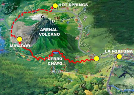
Transportation between San Jose and Monteverde is relatively painless. You can easily get to the Arenal volcano, as well.

costarica-monteverde

I recommend it. Monteverde Cloud Forest Reserve is one of the best hikes in Costa Rica.

more photos

TrekkingPartners on the Nepal disaster

via email …

Dear Trekkers,

It’s been ten days since a large-scale earthquake shook Nepal. It’s been a hard time for everyone, with the loss of family members, homes, entire savings, and historical landmarks. On the other hand, it’s brought the people of Nepal together in the face of adversity and strengthened bonds with those from outside Nepal who offered aid.

Still, with the death toll estimated at 7500, along with 10,000 injured and 1.4 million in need of food assistance, there is still a need for assistance.

We’ve spent the last few days compiling a list of reliable, effective groups working hard to bring support to the people of Nepal. If you’re able, please consider donating time, money, or volunteering via the links below.

What’s Needed Now

  • Remote villages are still in need of relief;
  • Because of sanitation problems, there is a high risk of disease;
  • Lack of electricity and water supply;
  • The monsoon season is a month away, making shelter an urgnet need;
  • Basic necessities like food, water purification tablets, medicine, blankets, and tents are still needed;
  • Support for the long-term rebuilding of homes, villages, and historical landmarks.

Effective Ways To Donate

If you are in a position to donate, here is a list of local, grassroot initiatives working hard to provide relief. By donating to these groups, your money will go directly to the people that need it most via local channels mobilized by local experts:

  • Rebuild Langtang Campaign Langtang village, in particular, will need rebuilding support after the first weeks have passed. After first medical care has been delivered it will take large efforts to re-establish community life back in the valley.
  • Lokesh Todi’s Relief Fund to support and sustain the work of local NGOs and first responders on the ground.
  • Mountain People’s Initiative to provide assistance to those in need around Kathmandu. They’ve set up a temporary relief centre in Thamel functioning as shelter/store/aid post for local Galdunga people.
  • Tsum Nubri Relief & Recovery Program set-up by the local people based in Kathmandu.
  • Sherpa Gear’s CrowdRise Campaign. 100% of your donation will go for immediate relief on the ground through our Paldorje Education Fund network, already set up to benefit the children of Sherpa families in remote villages.
  • Tripureshwor Village Aid Campaign: raising money to distribute rice to 300 families in Dhading Region (close to the epicenter).
  • GlobalGiving’s Campaign to help address the immediate needs for food, fuel, clean water, hygiene products, and shelter. Once initial relif work is complete, remaining funds will transition to support longer-term recovery efforts run by loca, vetted organizations.
  • Karma Foundation is a non-profit branch of socialtours & Karma Coffee working on responsible philanthropy disbursement to projects in Nepal, now for Quake relief.
  • Seva Foundation is working to supply tents to those in need of shelter.
  • To Da Loo Community toilet builders initiative in the wake of the earthquake. Toilets or latrine pits are raised in densely populated communities.
  • Helter Shelter Shelter relief effort for those left homeless.

Other Ways To Help

There will be long-term rebuilding projects that will need volunteer support. If you’re planning a trip to Nepal in the future, consider volunteering as an option. When the media spotlight shifts to another problem in the world, there will still be people in Nepal working to rebuild and regain what was lost.

Continued News, Updates, Photos…

Please share these links with others whom you feel can help. Thanks for your support, and hope to see you back in Nepal someday soon.

Best wishes,
Alex
Founder | TrekkingPartners

get paid CDN$20,000 plus expenses to HIKE

Trans Canada Trail 6 days a week from May 12th to Sept. 30th, 2015.

Woods Canada:

We’re hiring 2 Woods™ explorers for the ultimate Canadian Dream Job!

You will be awarded a contract and be paid to explore the Trans Canada Trail and share your adventures while using the latest Woods™ gear! Apply as an individual, or as a pair. Submit a 60 second video and tell us why we should choose you.

Submissions are due by April 17, 2015!

Click PLAY or watch it on YouTube.

details

(via MSN Money)

new Kilimanjaro route – 9 days

Adventure Blogger Kraig Becker:

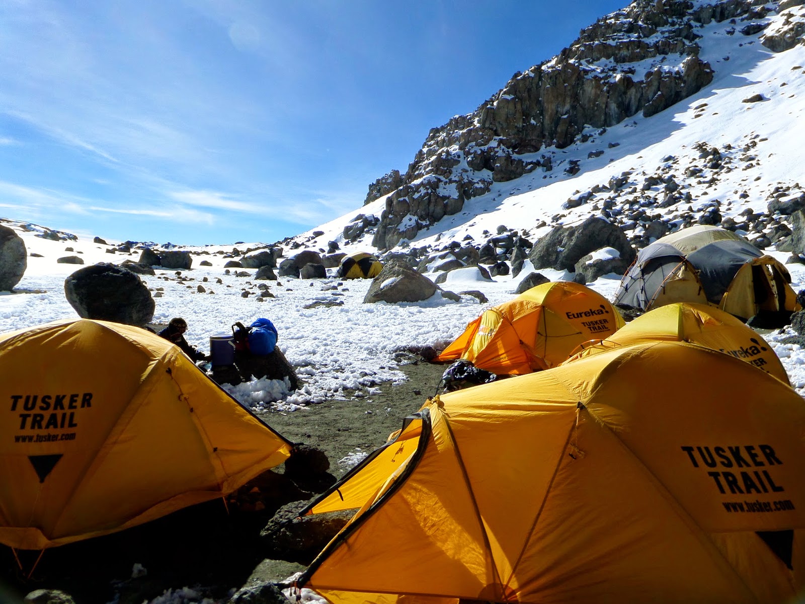
… When selecting the route for the Climb for Valor, the team at Tusker Trail decided that they wanted to do something a little different. The idea was to give the climbers on our team a complete unique look at the mountain, along a route that is seldom hiked. We began by entering Kilimanjaro National Park at the Londorossi Gate and proceeding up the traditional Lemosho Route along the western flanks of the mountain. …

On Day three we began to divert from the Lemosho Route at last and ventured out onto the all-but abandoned Northern Circuit of the mountain. At this point, we left all other teams behind and had the trail completely to ourselves. …

Kilimanjaro 2015: The Route

Crater Camp 5700 meters (18,700 ft)

Greg Aiello – how to pack a pack

Star of Outside Television’s TV show Motion, Greg Aiello, demonstrates his system for packing a pack.

It’s not particularly light weight. 😦

Click PLAY or watch it on YouTube.

More Outside Television videos.

related – REI’s Noelle Thurlow’s system for packing a pack (VIDEO)

Luxury Mount Everest Base Camp Trek

Freya Render:

… Although I love hiking, I also love comfort so I started searching on-line for an “Everest Luxury Trek” and found the Yeti Mountain Homes, a group of luxury lodges located on the classic trekking route in the Khumbu area. I contacted them and as from that moment I was blown away by the Yeti Mountain Home experience … a lovely lady called Pasang patiently and very professionally answered all my questions and created a customized itinerary for us. …

Unfortunately there are no Yeti Mountain Homes (yet) all the way up till Everest Base Camp but Pasang made sure that we had the best possible accommodation in every place. …

Luxury Mount Everest Base Camp Trek 2014 (Yeti Mountain lodges)

YMH Monjo Bathroom

Everest Base CampOur Everest information page.

Hike the Wakhan Corridor in Afghanistan

Kraig Becker linked to a trek I’d not known.

Remote and rugged, the Wakhan Corridor is an almost-legendary strip of land that extends from Afghanistan to China, with Tajikistan bordering to the north, and Pakistan to the south.

Surrounded by the snowcapped peaks of the Hindu Kush, Pamir, and Karakoram mountains, it is a spectacularly beautiful part of the world that remains virtually unknown to the vast majority of outsiders. Populated almost entirely by nomadic herdsmen, the Corridor is a realm of stark beauty, difficult terrain, and some of the most breathtaking landscapes on the entire planet.

Travel through the Wakhan Corridor in 2015 as part of an expedition led by Secret Compass. The trip is 21 days in length, and departs on July 20. …

adventuretravel.about.com – 10 Big Adventures For 2015

Click through to see that and the rest. 🙂

Wakhan

Simien Trek Ethiopia – day 4

trip report by site editor Rick McCharles

day 1 | day 2 | day 3 | day 4 | info

Day 4: Chenek-Buwahit, 4-6 hrs walking

We were up before the dawn, wanting our best chance of success climbing Mt Bwahit.

P1330997

Our guards had slept outside beside the tents, despite the cold.

P1340002

The day before our arrival a young Swiss couple had had their daypack stolen. Cameras, money … passports. 😦

It happens all over the world. It happens here, but not very often. Best guess was that one of the mule drivers had grabbed it. Might have been a young shepard boy, though they are chased out of Camp right quick.

I had my valuables strapped to my waist in a passport case, as always.

P1340001

Our guide had said that our best chance to see Walia Ibex would be this morning. We weren’t disappointed. We saw a number up on a ridge. And later down by the road. They are not shy.

P1340083

… only about 500 individuals survived in the mountains of Ethiopia, concentrated in the Semien Mountains, largely due to past poaching and habitat depletion. If the population were to increase, the surrounding mountain habitat would be sufficient enough to sustain only 2,000 ibex. The adult walia ibex’s only known wild predator is the hyena. …

I was still feeling weak though I had not lost my dinner from the previous evening.

I’d not slept much. Happily, as we climbed, I seemed to get stronger.

Though we ascended about 800m in less than 3 hours, it wasn’t all that cold. The sun helps for sure. We added and removed layers frequently.

P1340013

Disappointingly, the road winds up close to the top of the mountain. At times we walked it.

There’s not much traffic, of course. Clouds rolled up the escarpment early. We’d need to reach the top before the clouds did.

P1340029

We were very surprised to see snow on the top.

P1340033


P1340038

This is one of the few spots in Africa where snow falls regularly.

Nadine found snow in Africa

P1340046

Mt Bwahit (4430m) is the third highest mountain in Ethiopia and the 13th or 14th highest in Africa.

This is as far as we got following the escarpment. But the road continues to Mekane Berhan, 10km past the Park.

P1340045

In fact you can keep going 17 days all the way to Lalibela, if you like.

We celebrated with summit photos.

Simien - Josh and Nadine-2

Simien - Josh and Nadine-3

Simien - Josh and Nadine

I left a Summit Stone in the cairn.

Nadine turns back. She’ll be reunited with her husband later in the afternoon.

P1340064

Neither Nadine or I felt many altitude symptoms. Lucky. She gave some medication, on the trail, to one of the other hikers who was feeling rotten.

Obama is wildly popular in Africa though most distrust the American government.

P1340067

We saw many more baboons on the descent. We’d left too early to see them on the way up.

P1340070

The decent was quick. Psychologically, I was ready to go. The Simien a success.

P1340075

In most high mountains lammergeier (bearded vulture) stay far away from me. But here they float right over your tent. After many attempts, this was the best photo I got. They have up to nearly 10ft (2.83 m) wingspan.

P1340091

Here’s Josh’s best photo.

lammergeier - Josh and Nadine

In Ethiopia, they’ve become more tolerant of people, now common near trash piles on the outskirts of small villages and towns.

We saw wild chickens on the way down, too. Nur told us that when he was a shepard, age-5 to age-10, he loved to try to catch one for dinner.

Heading out, I risked eating lunch.

P1340093

Nadine was the one of the few hikers who completed ALL the original planned itinerary. But she was ready to head back to Gondor.

P1340094

It’s a long, bumpy ride back to the Park gates. The roads are bad even in a Toyota Landcruiser.

The closest good hospital is in Dabark. If you crash like this 😦 … they have an ambulance. Another ambulance, I mean.

P1340107

Rich tourists from the highest lodge in Africa take a short day hike to see baboons. Or do a tourist ride. Meh.

P1340103

We tipped around 10% of our tour cost, aside for the cooks who got almost nothing. If the clients get sick, the cooks didn’t do the job.

I suggested to Mohammad, a super guy, that he and the other cooks put a big bottle of alcohol gel on the dining tables. Every time. And to ask cooks and assistants to use it non-stop while preparing food for foreigners.

About half of the hikers I spoke with had stomach problems. Clearly the cook house is not sanitary enough. Cooks work together. If one has dirty hands, it’s possible that all the food will be infected.

When we arrived at the Four Sisters restaurant in Gondar that evening, to celebrate, there was a large bottle of alcohol gel on the table. But don’t expect to see one on a Simien trek any time soon. Inertia is great in Africa.

Four Sisters

I’ll suggest to future hikers that they consider bringing their own stove, cook their own food.

Nur and Hailie

Thanks to Nur and Halie, childhood buddies, who are still working together. Nur Hassan is Coordinator for SimienMountainsTour.com. I’ll be recommending them.

Our cost was $1000 for 3 people for 4 days, all inclusive. The lowest price I heard quoted was $250 each for 7 people in one group.

more photos

day 1 | day 2 | day 3 | day 4 | info