
trip report by site editor Rick McCharles
Chato Volcano, sometimes called “Cerro Chato” (Spanish for “Mount Chato”), is an inactive volcano in north-western Costa Rica …
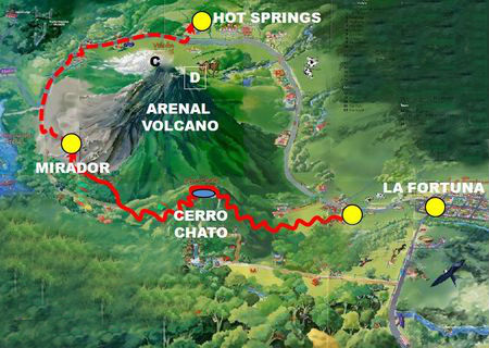
It is southeast of the nearby Arenal Volcano …
A crater about 500 metres (1,600 ft) wide is filled with a lagoon, Laguna Cerro Chato. …

Since I hate taxis, I instead walked the 3.5km from La Fortuna town to Cerro Chato Eco Lodge.
Paid $12 for the hike. And $4 for two Diet Cokes. (One of the ’10 essentials’ of hiking.)

Many tourists feel prices are too high in the Arenal area. I agree.
The weather looked bad. Normal for the rainy season here.

Still, I was psyched. I love climbing volcanos.

There were some views.

You have to get lucky to see animals on popular trails here. I saw only birds.

And cows. There are plenty of cows.

It’s steep in parts. Muddy. You must scramble tree roots.
Everyone gets sweaty, regardless of their fitness. It’s hard work in a humid environment.
I stopped at the volcano rim, however, when two hikers told me they had given up on the steep, muddy descent to the water. ’Sketchy’, they warned.
We agreed that there was not much to be seen down there, in any case, as the summit was cloud covered.
After hiking down quickly, I ran some of the 3.5km downhill back to my hostel. A big day, all-in-all. My celebration meal was Calzone. I was hungry. 🙂
related – Trip Advisor – Cerro Chato

Cool, thank you very much for your wonderful review of Costa Rica, this information will be very useful to me at my holiday.