FANTASTIC.
Trip report coming soon.


Best hikes, treks, tramps in the world.
FANTASTIC.
Trip report coming soon.
New super trek conveniently close to EsCape Town, South Africa.
5 Days
Hike from Table Mountain to Cape Point on this exclusive Hoerikwaggo trail in Cape Town. (87.9km)
… the only organised 5-day hike from Cape Town all the way to the most southwestern tip of the African continent, while your accommodation, meals and luggage are all taken care of!
Guests will be staying in permanent tented camps & chalets, exclusive to this hike, on top of the mountain and other places of interest (Cape Town, Kommetjie & Simonstown). This Hoerikwaggo Trial has a minimum of 4 and a maximum of 12 hikers at a time
Highlights: Table Mountain, Hout Bay, Silvermine, Kommetjie, Simonstown, Cape Point
Departure Dates 2010: Departs every Sunday from Cape Town
Book months in advance.
Read reviews on Trip Advisor.
There are plenty of independent options to and from Table Mountain too. The new Hoerikwaggo is recommended to those coming for the first time, who want everything organized for them in advance.
They offer shorter versions, as well.
The luxury, guided alternative to the famed Otter. Same gorgeous South African scenery.
For two magical days you can now hike the magnificent Tsitsikamma Coast with no heavy backpack, and spend three nights in comfort at different accommodation venues!
Click PLAY or watch it on YouTube.
official website – Dolphin Trail
by site editor Rick McCharles
I’m making my first pilgrimage to the hiking Mecca of South Africa.
One of our top 10 coastal hikes worldwide.
Otter Trail April 6-10th, 2013
The Otter Trail is a hiking trail along the Garden Route coast of South Africa and is named for the Cape Clawless Otter which occurs in this region.
… widely regarded as one of the finest in the world and stretches from Storms River Mouth in the east to Nature’s Valley in the west, is 26 km long as the crow flies and 41 km as the hiker walks.
Walking the trail takes 5 days, and the 4 nights are spent in comfortable huts with superb views. The route is located entirely within the Tsitsikamma National Park, which protects an 80 km long strip of coastal mountains, forest and beaches.
… an extremely scenic landscape, never straying far from the shoreline, but often climbing steeply and then descending to the beach or a river crossing. …
Jens Niere’s trip report video gives a good feel for what I have to look forward to.
Click PLAY or watch it on YouTube.
Some serious water crossings. 😐
Skurka was there, too. (VIDEO)
• DAY 1: Storms River Mouth to Ngubu Huts – 4.8kms – 3 hours
• DAY 2: Ngubu Huts to Scott Huts – 7.9kms – 6 hours
• DAY 3: Scott Huts to Oakhurst Huts – 7.7kms – 4 hours
• DAY 4: Oakhurst Huts to Andre Huts – 13.8kms – 8 hours
• DAY 5: Andre Huts to Nature’s Valley – 8.3kms – 3 hours
It’s tough to get a hiking permit. But by applying solo, and being flexible on start date, I was able to nab one in high season only a couple of months in advance.
total cost – 1348.60 Rand ($150)
The Wales Coast Path … is a long-distance footpath which follows the whole of the coastline of Wales. It opened on 5 May 2012, and offers a 870 miles (1,400 km) walking route from Chepstow, in the south, to Queensferry, in the north.
Wales is the first country in the world to provide a dedicated footpath along its entire coastline. The Path runs through 11 National Nature Reserves and many more local Wildlife Trust and RSPB reserves. …
The 870 miles (1,400 km) of the Wales Coast Path links with the Offa’s Dyke Path National Trail, which loosely follows the border with England, to create a 1,030 miles (1,660 km) continuous walking route around the whole of Wales, although skirting past Flintshire and Wrexham. …
Click PLAY or watch some highlights on YouTube.
Controversy
The Open Spaces Society has criticised some landowners who do not allow the path onto their coastal land. This means 170 miles (270 km) – more than 20% of the route – will be on roads, sometimes out of sight of the sea.
Tim Cheung:
Highly addictive, mildly dangerous: four hiking gurus come clean about their obsession
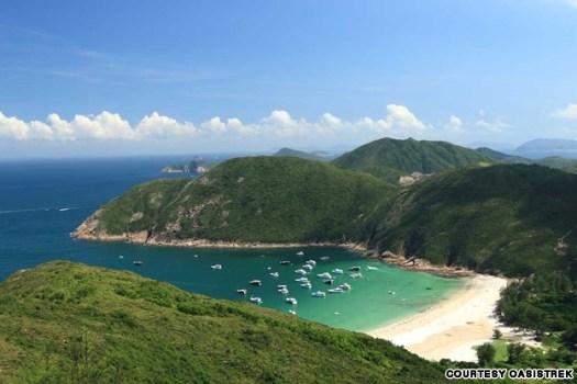
… 300 kilometers of designated trails, varying in length and difficulty, traverse the territory and many locals hike religiously.
To really experience Hong Kong get out to one of the four major hiking trails: the MacLehose Trail, Wilson Trail, Hong Kong Trail or Lantau Trail.
Click through for advice on perhaps the best urban hiking area in the world.
related – Budget Hong Kong: Coward’s Route To Victoria Peak
I’ve been following Photodiary of a Nomad for years.
This couple have documented 6200km+ of walks and over 12000 photos.
Summer 2012 they started on the Pacific Coast, worked their way through the Rockies, and finished amongst the magnificent colours of the eastern forests in autumn:
Prologue
West Coast Trail (Gordon River to Walbran Creek)
West Coast Trail (Walbran Creek to Pachena Bay)
Vancouver Urban Fringe Walk
Skyline Trail – Jasper National Park
The Icefields Parkway
Assiniboine Day-Walks
Assiniboine-Sunshine Meadows Trail
Banff National Park (Two Teahouses and Larch Valley Hikes)
Yoho National Park (Iceline Trail and Lake O’Hara Circuit)
A Tale of Two Cities (Montreal and Quebec City)
Mont Tremblant by foot and canoe
La Mauricie National Park
Saguenay Fiord Trail
Hopewell Rocks (Big Tide in the Bay of Fundy)
Cape Breton Highlands National Park
Wanderings in New Brunswick
Not all of those trip reports are live yet. They are still being uploaded.
They walked our #1 hike in the world, the West Coast Trail.
Their words — never before spoken — about the WCT:
… The clear morning skies were becoming a bit monotonous, as dawn arrived with a pink glow on the eastern horizon. …
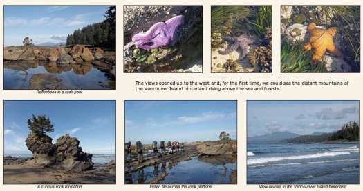
That’s a great trip report for anyone planning for the West Coast of Vancouver Island. In fact, I’m hoping to get back again summer 2013. 🙂
related – some of their best photos from past trips around the world
Alex Cherney:
This time lapse video is the result of almost 1.5 years of work, 31 hours of taking images during six nights on Southern Ocean Coast in Australia. …
Click PLAY or watch it on Vimeo.
Thanks Ron.
New Zealand is our #1 hiking destination in the world. Here’s the contest of a lifetime.
Air New Zealand:
Do you think you’re the perfect curious adventurer to take on the Great Walker Challenge? In their latest adventure travel contest beginning Tuesday, September 25th, Air New Zealand is searching the globe for four lucky adventurers to trek all nine of New Zealand’s Great Walks over the course of nine weeks. … (FEB-MAR 2013)
To enter, you … will need to submit a short YouTube video or Pinterest board that describes why he or she deserves a spot. Submission will be accepted through October 22.
Here’s a peek at what the lucky four will experience:
Click PLAY or watch it on YouTube.
The nine Great Walks include the Abel Tasman Coast, Heaphy, Kepler, Lake Waikaremoana, Milford, Rakiura, Routeburn, Tongariro and Whanganui Journey.
· To enter: www.greatwalkernz.com
For information on Air New Zealand’s Great Walks vacations: www.airnewzealand.com/greatwalks
Update: This adventure is tough. If you are not 100% confident consider booking a guided hike with MB Guiding.
Don’t hike the “standard” NCT without a GUIDE.
by site editor Rick McCharles

One of the best hikes in the world is the …
North Coast / Cape Scott Trail, Vancouver Island, BC
It’s PARADISE … so why are we NOT recommending it?

Read on …
The NCT is a “backcountry adventure“, not a hike. There’s a reason some groups manage only 1km (.6mi) / hour on some sections.
On the other hand …
Our #1 hike worldwide is the nearby West Coast Trail.

The North Coast Trail is the newest (2008) of the WCT alternatives. An alternative way to spend time in this wild coastal temperate rainforest. It’s billed as “the WCT circa 1970“.
Was the WCT this bad in 1970? … Probably.☹️
STANDARD ROUTE:
• the North Coast Trail is a 43.1km extension to the original Cape Scott Trail. The total hiking distance Shushartie Bay (from water taxi) to San Josef Bay & Cape Scott Trail parking lot is a minimum of 59.5km (37mi).


• the only ways to get to the NCT are by logging road (64km from Port Hardy), water taxi or float plane.
• actually, a few masochists have bushwhacked in to Shushartie from Port Hardy. Dumb idea.
• best hike is to decide as you go where you want to camp. An “open” itinerary. Base your decisions each day on tides, weather and how you feel.
• many do 7 days, 6 nights on the standard NCT trail but — if you — instead — start at the parking lot, any number of days works. If you have serious problems, walk out.
• often you can choose between an inland path or a coastal route. The coast is almost always better. Certainly more scenic.
• the most detailed route report of the STANDARD NCT was posted in Wild Coast (2008) Shusartie to Laura Creek:
1. Shusartie overland (Shusartie to Skinner)
2. The Nahwitti Stretch (Skinner to Cape Sutil)
3. The Sutil Scramble (Cape Sutil to Irony)
4. Christensen Coast (Irony to Laura)
5. Nahwitti Cone (Laura to Nissen)
… walk out via the easy Cape Scott Trail
Though I had a challenging, terrific experience Sept 2012 (see trip report) … my recommendation is NOT to do what I did. Don’t hike the STANDARD NCT (minimum 61km). You can do better on Vancouver Island.
The new trail is extremely difficult where you start in the east. And gets easier as you head west and then south.

The beaches and trails are “better”, too, I felt, in the older western & southern parts of the Park.
Instead of the standard North Coast Trail: water taxi to Shushartie to Cape Scott Trail parking lot, better itineraries are:
• hiking the easier West Coast Trail, instead
• hiking the much easier Juan de Fuca Trail, instead
• or — best of all — hiking the North Coast Trail, differently:
_____
HIKE DIFFERENT – option 1 of 2:
~ start Cape Scott Trail parking lot (getting there by personal vehicle or Shuttle Van) -> hiking as far into the North Coast Trail as you wish -> then backtracking to the parking lot.
That in-and-out hike gives you many, many options. You can decide what you want to do, as you go. Keeners in your group can go further east, while others in your group relax on a favourite beach.
The very worst section, in our opinion, is Skinner – Shushartie. You can stop when you get to Skinner, if the going is rough.
Downside?
Some hikers hate backtracking. No worry, in this case. The Trail looks completely different walking in different directions. It changes, too, with the tide. Trust me — you won’t be bored.
If you don’t have your own vehicle, you’ll somehow have to arrange the Shuttle to come pick you up.
_____
HIKE DIFFERENT – option 2 of 2:
Start at Skinner. Or even Cape Sutil.
… Why doesn’t everyone do that?
“Park Facility Operators” by email:
Shushartie is by far the safest and most reliable place to drop off hikers. It can be reached at all tides by most boats. I completed a survey of the coastline with the Coast Guard and they also recommended keeping Shushartie Bay as the primary access point strictly from a safety perspective. It is also a hardened area that is not negatively impacted by constant boat landings. …
Though more materials for boardwalk has been airdropped alongside the Trail, I heard money had run out. There has been some controversy regarding the funds expended, too.
_____
If I was going again next year, I’d start at the Parking lot. Not Shushartie.
… Are we being too hard on the Skinner – Shushartie slog?
“Park Facility Operators” by email:
It’s unique due to its rare vegetation and tree species, its endangered (and protected) fish and amphibian species and its ability to positively affect the rest of the park’s functioning ecosystem. All rare and unique. These types of ecosystems are often referred to as the lungs of our environment.“Park Facility Operators” felt that it was very important to represent this ecosystem as part of the hike. It is very unique and like I say, one of the primary reasons this part of the park was created, from a conservation perspective.
Those upland bogs are interesting.

But visiting them requires one day of your life.
WHY WE LIKE THIS HIKE:
• North Coast Trail is like the West Coast Trail without the hassle of getting a “Trail Use Permit”
• west coast of Vancouver Island is fantastic. This truly is one trek that could change your life.

• NCT camping is only C$10/person/night. May to Sept. You can buy backcountry permits online, or pay cash at the trailhead. Honour system.
• no quota on number of hikers (WCT allows only 60/day)
• no reservations needed
• you can hike NCT / Cape Scott year round, weather permitting, while the full WCT is only officially open 5 months a year. (However, the Water Taxi stops running around Sept. 15th each season.)
• gorgeous beach campsites with sunset views. Nel’s Bight beach is 2.4km long and 210m wide at low tide. Sweet.
• some old-growth forest including giant Sitka Spruce & Western Red Cedar
• pretty sea stacks and other fascinating coastal geology
• tidal pools, bogs, riparian areas, …
• good tent pads, far better than on the West Coast Trail
• campfires allowed. Plenty of drift wood.

• chance to see whales & other marine mammals, bald eagles, river and sea otters, mink, deer, elk

• everybody loves Guise Bay & Experiment Bight
• few biting insects on the coast (you will find mosquitoes inland out of the wind)
• possibly a few horseflies inland (not to mention millions of weird, but non-biting, beach hoppers on the coast)
• creek crossings are only an issue when in flood.
• two new cable cars propel you over the only major rivers
• theft and vandalism of parked vehicles is normally no problem at Cape Scott trailhead, San Josef. No parking fee.
• wild (dispersed) camping is allowed
• many set up tents protected within “fortresses” (temporary beach shelters made of drift logs). “Park Facility Operators” asks that you dissemble those, when finished
• beach-combing is fascinating, look for wreakage from Japan
• the Cultural Heritage of this area is fascinating. Signage explains the history of native peoples and the failed Danish colonies
• you’ll see BEARS and WOLVES in the wild 🙂

CONSIDERATIONS:
• you’ll see BEARS and WOLVES in the wild 😦
• bears and hikers both love: berries, low tide, trails

• it’s MUDDY, … really, really MUDDY
• did we mention it’s MUDDY?
• prepare for slippery rocks, roots and logs. Eyes blinded with rain, you’ll need to scramble up, over and between giant stumps. With a full pack.
• most wear waterproof hiking boot with high gaiters. It’s a gamble to wear anything else — 5-10 water shoes, for example.
• most hikers get blisters. Bring moleskin, or whatever works best for you
• most hikers bring a second pair of footwear for camp
• consider bringing one or two hiking poles. There are many wooden walking sticks to be found in the campsites, as a back-up
• you must scramble fallen trees, steep slippery slopes sometimes assisted by muddy rope
• expect to fall on your face. Most often at a moment when you’re not paying attention to your footing.
• so far “Park Facility Operators” has recorded more injuries on the “cobble beaches” than any other terrain. Slippery boulders can be ankle busters.
• bring a first aid kid. There are 3 Ranger stations, but many parts of the trail are not regularly patrolled. Plan to be self-sufficient in any emergency.

• water is a problem in this Park, sources few and far between. By end of season some sources are reduced to a trickle. Or seep. Boil, filter or treat. Collect rain water with a tarp, if you get the chance.

“Park Facility Operators” by email:
Perennial streams on coastal trails, including the NCT, are hard to predict. With such little relief and few lakes to store runoff, it all comes down to recent rain fall. Even the big streams like Nahwitti and Stranby are tidally influenced and are brackish near their mouths. …
• best bring more water carrying capacity / person (perhaps 4 litres / person)
• if you do decide to go, get the only dedicated guidebook
• signage is terrific on the Cape Scott Trail, but minimal on the new NCT. Most hikers are working off the $10 Wild Coast Map
• when the NCT was built, the signage was combined with the Cape Scott Trail for consistency. Makes sense.
• fishing is permitted as per provincial and federal fishing regulations. Nobody was catching anything when we were there.
• leashed dogs allowed — but NOT recommended. There’s a chance they’ll run into wolves. UPDATE – we’ve heard dogs are no longer allowed on the trail.
• no emergency phone. No phone coverage. (Marine radios can be rented from North Coast Trail Shuttle. If you call, evacuation costs about $1000 … IF they can get to you.)
UPDATE from George of North Coast Trail Shuttle:
Only 2 injured hikers picked up in 2012. at no cost, 1 heli 1 coast guard. We picked up 2 on different days that called in to say they were done. 1 pooped 1 mild knee strain. They paid seat price as we were in the area.We have only had one group pay the charter rate of $1000.00 in 5 years. Most get picked up next morning for discounted rate after we drop off others.
• bring your own satellite phone if you want to maximize safety. VHF radios are going to work. SPOT locators are fairly unreliable, in my opinion.
• sections of the trail are impassable or very difficult at high tide. Check tide tables posted at most official campsites. Get tide tables in advance, as a back-up, in Port Hardy. Jot them down from signs (if posted) in campgrounds, as they may be slightly different
• May to October are the best months
• we like August and early September best of all
• off-season this part of the world is very cold and rainy
• some consider Cape Scott Lighthouse a bit of a letdown. It’s not on the sea.
• rogue waves can knock an inattentive hiker into the sea
• expect torrential rain and wind. You need a good waterproof tent and tie-downs. And clothing for those conditions.
• keep a dry set of clothes in a waterproof bag, for wearing inside the tent
• summer highs around 14C (57F)
• risk of hypothermia
• bring parachute line to hang food from a tree as a back-up, in case you don’t make it to an official campsite, for any reason. There are bears everywhere.
• bear-proof metal food caches are widely available, actually. Near essential in this bear country.

LOGISTICS:
• almost everyone arrives Port Hardy by the only lonely highway. It’s 499km from Victoria, 412km from Vancouver (plus ferry).
• a terrific alternative, would be to arrive or depart by BC Ferry from Prince Rupert. (From Rupert you can catch the Alaska Marine Ferry, something I did once. A superb trip up the Inside Passage.)
• bring stove fuel with you to Port Hardy as stores may be closed
• public transport is convenient
~ one Greyhound bus a day
~ walk a couple of blocks to one of two hostels. There are many hotels, too.
~ walk to the North Coast Trail offices at the Marina, morning of transit
• both the hostel & North Coast Trail Shuttle will store a small bag for you, while you are gone. Your small bag with CLEAN clothes.
• the city of Port Hardy maintains an updated list of transportation options.
• no reservations are needed to hike the North Coast Trail. But you must book both van shuttle (San Josef) and/or water taxi (Shushartie) in advance. To get a good price you need a number of hikers taking that transport at the same time. North Coast Trail Shuttle rents VHF marine radios too ($50+tax).
You can prepay your $10/night/hiker to North Coast Trail Shuttle, as well. Very convenient.
BEST TREKKING GUIDEBOOKS:
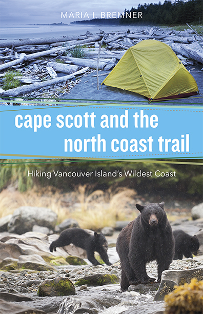
Cape Scott and the North Coast Trail by Maria Bremner (2015)
HIKING TRAILS 3 – Northern Vancouver Island (9 pages) – $31
OTHER RECOMMENDED BOOKS:
• Plants of the West Coast Trail – Collin Varner
• Back Country Bear Basics – David Smith
• A Guide to West Coast Hiking in British Columbia and Washington State – Philip Stone
BEST MAPS:
• most used map by far is FREE online from Wild Coast. You can buy a hard copy via that link for $14.95.
You might be able to buy it in Port Hardy, as well..
• BC Parks – map (PDF)
• National Topographic Series Maps, Scale 1:50,000, Index No.102, Sheets 1/9 and 1/16, cover the Cape Scott area. Available at most map retailers in British Columbia.
BEST VIDEOS:
Cape Scott Park has a Flash-based Virtual Tour. Click around to discover highlights.
Mikecyclone 2012 – HIKING THE NORTH COAST TRAIL
MrPortsider 2012 – Wolf pesters Bear North Coast Trail
GUIDES:
Coastal Bliss – The North Coast Trail and Cape Scott Park
9 days-Strenuous – CDN$1,799 + 12% HST
Sea to Sky – The North Coast Trail and Cape Scott Park
CDN$1799 + 12% HST [Federal Tax]
BEST WEBSITES:
After this page, the best links are:
Wild Coast Publishing – Explore the Best: The North Coast Trail, a primer
BC Parks – Cape Scott Provincial Park (est. 1973)
BC Parks – Hiking in Cape Scott Provincial Park
~ The North Coast Trail by paddle
~ The North Coast Trail versus the West Coast Trail
BC Parks – Bear Safety
BC Parks – Wolf Safety
BC Parks – Park User Fees
Port Hardy Transportation options
Wikipedia – North Coast Trail
Wikipedia – Cape Scott Provincial Park
North Coast Trail Backpacker’s Hostel (Trip Adviser)
C&N Backpackers Port Hardy (Trip Adviser)
There are many hotels & motels in town, all within walking distance.
BEST PHOTOS & TRIP REPORTS:
Wild Coast Magazine – Route details
Cape Scott and the North Coast Trail guidebook – photos
RichSo’s trip report has fantastic photos

Smile With Your Heart – 2011

Sam Yeaman – North Coast Trail – 2012
Club Tread – North Coast Trail with GPS Waypoints
Jeff Hunt and Bob Wall’s 60k Trail Run – May 10th, 2008 (Opening Day)
David Crerar & 3 others Trail Run – May 2008
Rick McCharles – North Coast Trail photos – 2012
Trees Rocks Dirt – trip report – 2010
Joyce Peralta – North Coast Trail photos – 2009

Leave a comment if you have feedback. Thanks!
But don’t say you weren’t WARNED.
more photos shared by Sam Yeaman


